
Epirus tours are trips through the mountainous north-west of Greece, from the stone villages of Zagori and the Vikos Gorge to Ioannina, Metsovo and the coast at Parga. The page is part of the Greece Tours on Greece Ville.
This page covers what Epirus tours are, Zagori, Ioannina, Metsovo, Tzoumerka and Arta, the Acheron and Preveza, and the Parga coast. Common questions come last. Each section links to the Greece Ville posts on single tours.
What are Epirus tours and which region do they cover?
Epirus tours explore a rugged region of northwestern Greece, where mountain villages, stone bridges, lakeside towns and Ionian beaches lie close together, and where only around 320,000 people live across a very large landscape of peaks and valleys.
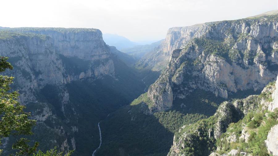
Epirus is both a traditional geographic region and a modern administrative one. The Ionian Sea lies to the west, Albania to the north, and the Pindus Mountains separate it from Macedonia and Thessaly in the east.
The present region was created in the 1987 administrative reform, and the 2011 reform later replaced prefectures with regional units. Epirus tours therefore cross land that the ancient Molossians and Thesprotians once held.
Ioannina is the capital and largest city, and nearly a third of the population lives there. The rest of the region is thinly settled, partly because wars in the twentieth century and mass emigration drained the villages.
Herding shapes the local table. Sheep and goat pastoralism has always been an important activity, and Epirus supplies more than 45% of the meat sold on the Greek market. Dairy brands that make feta also come from here.
- Population: The 2001 census gave Epirus the lowest population of the 13 regions of Greece.
- Capital: Ioannina is the largest city, and its lake and castle anchor Epirus tours across the centre of the region.
- Livestock: Pastoralism, especially of sheep and goats, remains a pillar of the rural economy.
- Visitors: Eco-tourism is an important part of the economy because of the natural setting and traditional villages.
The sections below follow Epirus tours from the mountain villages in the north to the Ionian coast in the west, and each linked post covers one place in greater detail.



Why do Epirus tours start in Zagori and the Vikos Gorge?
Epirus tours start in Zagori and the Vikos Gorge for stone bridges, deep limestone cliffs and a cluster of mountain villages that held a rare autonomy under Ottoman rule, in one of the least crowded landscapes in Greece.
Zagori is a triangle of the Pindus where only 3.4 inhabitants live on each square kilometre, against an average of 73.8 for Greece as a whole. The Zagori tours post covers the villages, bridges and trails of the region.
Human presence here is old. Excavations at Kleidi Cave, just above the Voidomatis river, found stone tools and fossils from the Palaeolithic and the Epigravettian culture.
The Voidomatis rises near the village of Vikos and ends close to Konitsa. A British team excavated the nearby cave between 1983 and 1986. The Konitsa tour post covers the town at the northern edge of Zagori.
In antiquity the area belonged to the Molossians, who used great mastiffs against wolves and bears. Olympias, the mother of Alexander the Great, was a Molossian princess, so Epirus tours also touch royal history.
- Rock: The upper layers of the Vikos wall are young Eocene limestone, while grey Jurassic dolomite dominates the deepest layers.
- Tea: The popular Sideritis raeseri, known in Greece as mountain tea, is among the herbs that local healers once harvested.
- Bridges: Expatriate merchants paid for the arched stone bridges in the eighteenth century, replacing older wooden ones.
- Roads: Mountain roads and bridges linked the villages until modern roads opened in the 1950s.
Epirus tours in Zagori therefore combine geology, river scenery and village history, and the two linked posts above give the detail for each place.
What do Epirus tours show in Ioannina and on Lake Pamvotida?
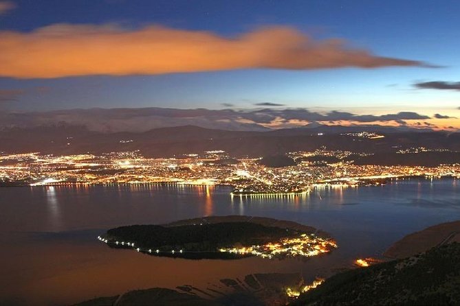
Epirus tours reach Ioannina, the lakeside capital of the region, for a fortress that carries Byzantine and Ottoman layers, a small lake island with seven monasteries, and a long record as a seat of regional power under a succession of rulers.
The municipality of Ioannina has 113,978 inhabitants. The city stands on the western shore of Lake Pamvotis, 410 kilometres northwest of Athens and 260 kilometres southwest of Thessaloniki.
The Ioannina tour post covers the city. In 1020 Emperor Basil II placed the local bishopric under the Archbishopric of Ohrid, and until 1867 Ioannina served as the administrative centre of the Ioannina Eyalet.
Lake Pamvotida has no surface outflow. Karstic sinkholes drain it towards the Arachthos, the Louros and the Kalamas, and a tunnel and ditch built in 1960 carry more water from its northern end to the Kalamas.
Ioannina Island covers 0.675 square kilometres and reaches 800 metres at its longest. A boat links it with the city, and the oldest monastery, Filanthropinos, dates from 1291 or 1292.
- Castle: The present walls largely date to the rebuilding under Ali Pasha, finished in 1815, which added a new wall in front of the Byzantine one.
- Citadel: The northeastern citadel covers about 6,000 square metres and keeps a monumental southern gate flanked by a round tower.
- Monasteries: Seven Late Byzantine monasteries stand on the island, and it ranks third among monastic states in Greece.
- Status: Until the 2011 reform of local government the island was run as a community, and it is now a municipal unit.
Epirus tours in Ioannina can therefore combine a fortress walk with a short boat trip, using the city as a base for the wider region.
How do Epirus tours cross Metsovo and the Pindus Mountains?
Epirus tours cross Metsovo and the Pindus Mountains in the north of the region, through a high mountain town with a long record of sheep herding, merchant wealth and local self-rule, and through a range that holds two national parks.
Metsovo is a town in the Pindus mountains of northern Greece, and its economy rests on agriculture and tourism, which flourishes in winter. The Metsovo tour post covers the town and its surroundings.
Residents of Metsovo opened a school as early as the beginning of the eighteenth century and sent students to European universities. A class of scholars, teachers and clergymen grew from this effort.
Until the early twentieth century local society split into three classes: wealthy traders called arhontzi, a middle group called vinitsi, and travelling sheepherders called algi. The vinitsi married among themselves but never with the algi.
The Pindus runs through Northern Greece and southern Albania. From the Middle Ages until the nineteenth century, the folk name of the range was Metsovo, or the mountains of Metsovo, and the twelfth-century writer John Tzetzes called it Metzovon.
- Exarchate: After 1659 the Metsovo area formed its own exarchate, and the exarch lived in Constantinople while a local clergyman did the daily work.
- Park: The Pindus National Park, also called Valia Kalda, covers 7,000 hectares north of Metsovo.
- Birds: Mountain lakes of the range hold breeding colonies of herons, spoonbills, egrets and pelicans, including the rare Dalmatian pelican.
- Bequests: A special logbook recorded the wills of local benefactors from the start of the nineteenth century.
Epirus tours through Metsovo therefore show how a mountain town built its own wealth, schools and customs inside a much larger empire.
Where do Epirus tours go in the Tzoumerka mountains and Arta?
Epirus tours go to the Tzoumerka mountains for wartime resistance history and river valleys, and to Arta for a famous stone bridge, a medieval castle and the memory of an Epirote capital that once stood beside the Arachthos river in the west.
North Tzoumerka is a municipality of 358.334 square kilometres, formed in 2011 from seven former municipalities. The Tzoumerka tour post covers the mountains, gorges and villages.
During the Axis occupation of Greece the main base of the EDES resistance organisation stood in the Tzoumerka mountain. That wartime role belongs to the local memory, alongside the herding and village life.
The Bridge of Arta crosses the Arachthos on the west side of the city. In the folk ballad, 45 masons and 60 apprentices built it, and its foundations collapsed each night until a human sacrifice was made.
Tradition holds that the bridge was rebuilt when Arta became capital of the Despotate of Epirus, possibly under Michael II Doukas, who ruled from 1230 to 1268. The Arta tour post covers the town.
The castle walls are on average 2.5 metres thick, and the inner wall stands about ten metres high. A hotel built in the 1960s wiped out almost all remains inside.
- Ballad: The bridge song gave Greek speech proverbs about interminable delays.
- Fire: In 1313 a great fire destroyed much of the city.
- Bishopric: Arta rose to become a bishopric by 1157, when the city flourished as a commercial centre.
- Transfer: The Arta area passed to Greece in 1881 together with Thessaly, under the 1878 Congress of Berlin.
Epirus tours in the Arta area therefore link a mountain range of wartime memory with a river town of bridges, walls and folk song.
What do Epirus tours reveal at the Acheron and in Preveza?
Epirus tours follow the Acheron towards the Ionian Sea and then continue to Preveza, a harbour city beside the ruins of Nicopolis, the Roman Victory City that is believed to have reached a population of 150,000 at its peak.
The Acheron drains an area of 705 square kilometres. The Acheron River tour post covers the river and its valley, which Greek tradition linked with the underworld.
The nearby Nekromanteion was an ancient oracle of the dead. Herodotus records that Periander, the sixth-century BC tyrant of Corinth, sent envoys there to question his dead wife, Melissa.
The excavated ruins, dug by Sotirios Dakaris from 1958 to 1964, are now questioned as the oracle. The Romans burned the site in 167 BC, and it yielded 21 bronze washers from at least seven catapults.
The regional unit of Preveza comprises the southern part of Epirus, and the municipality of Preveza covers 380.541 square kilometres. The Preveza dolphin watching post covers sea trips from the harbour.
- Name: The name Preveza derives from a Slavic word meaning passage.
- Siege: In September 1684 the Venetians, aided by Greek irregulars, crossed from Lefkada and captured Preveza.
- Garrison: 280 French grenadiers arrived under General La Salchette after the fall of Venice.
- Poet: The poet Rigas Feraios supported the ideas of the French Revolution and called for a Greek uprising.
Epirus tours in this corner combine a river of myth, a disputed ruin and a harbour city, which suits visitors who want history beside the sea.
How do Epirus tours reach the Parga coast?
Epirus tours reach the Parga coast along the Ionian shore between Preveza and Igoumenitsa, where a castle town with Venetian roots stands above a bay, and where a long record of rule, revolt and exile shaped its people.
Parga is a resort town known for its natural environment, and its municipality covers 274.796 square kilometres. The Parga boat trip post covers sea trips from the harbour.
Mycenaean tholos tombs have been found near Parga. The ancient town of Toryne stood there in the late Hellenistic age, and its name means ladle in Greek, after the shape of its beach.
Parga passed under Venetian control in 1401 as a mainland exclave of Corfu. The senate gave the citizens a ten-year tax exemption in 1454, and a Romaniote Jewish community was recorded in 1496.
In 1812 the Ottoman general Daut Bey captured the nearby settlement of Agia, massacred and enslaved its people, and died in the siege of Parga that followed. In 1819 the British handed Parga to Ali Pasha.
- Offer: Nicholas Orsini offered the town and its sugarcane proceeds to Venice in the early fourteenth century.
- Rebels: In 1570 anti-Ottoman rebels under Emmanuel Mormoris used Parga as a base of operations.
- Families: A Greek vice-consul reported 365 Christian and 180 Muslim families in Parga in 1877.
- Art: Francesco Hayez later painted The Refugees of Parga about the handover.
Epirus tours that continue to the islands can use the Ionian Islands tours page, and those that head east can use the Northern Greece tours page.
What do travellers ask about Epirus tours?
Epirus tours raise practical questions about the places, the landscape, the rivers and the history of the region, and the four answers below draw on the sections above, using plain facts about each place for every visitor who plans a route.
Which places do Epirus tours cover?
Epirus tours cover the Zagori villages and the Vikos Gorge in the north, the lakeside city of Ioannina, the mountain town of Metsovo, the Tzoumerka range, the bridge town of Arta, the Acheron valley, Preveza and the Parga coast on the Ionian Sea.
Why is the countryside on Epirus tours so quiet?
The countryside is quiet because the population is small. Epirus has around 320,000 residents, Zagori counts only 3.4 inhabitants per square kilometre, and wars in the twentieth century together with mass emigration emptied the villages.
What history do Epirus tours cover?
Epirus tours cover the Molossians of antiquity, the Byzantine bishopric of Ioannina in 1020, Venetian Parga from 1401, the Ottoman centuries under Ali Pasha, and the transfer of Arta to Greece in 1881, so the history spans more than two thousand years.
Which rivers appear on Epirus tours?
Epirus tours meet the Voidomatis beneath the Vikos Gorge, the Arachthos beside the Bridge of Arta, and the Acheron, which drains 705 square kilometres. The sinkholes of Lake Pamvotida also feed the Arachthos, the Louros and the Kalamas below ground.