

A Konitsa tour visits Konitsa, the mountain town of northern Epirus above the Aoos river, with its stone bridge, the Aoos gorge and its monastery, the links to Paisios and the rivers, crags and peaks around it. The tour is one of the Greece Tours on Greece Ville, listed with the other Epirus tours and Greece hiking tours.
This post covers the formats on sale, where Konitsa lies, its history, the stone bridge, the Aoos gorge, Paisios, the rivers and rafting, the mountain sports and the questions that come up before booking.
What is a Konitsa tour?
A Konitsa tour is a day or activity trip to Konitsa, a town in the Ioannina area of Epirus, north of Ioannina and close to the Albanian border. Listings cover via ferrata, rafting, a river walk and the house of Saint Paisios.
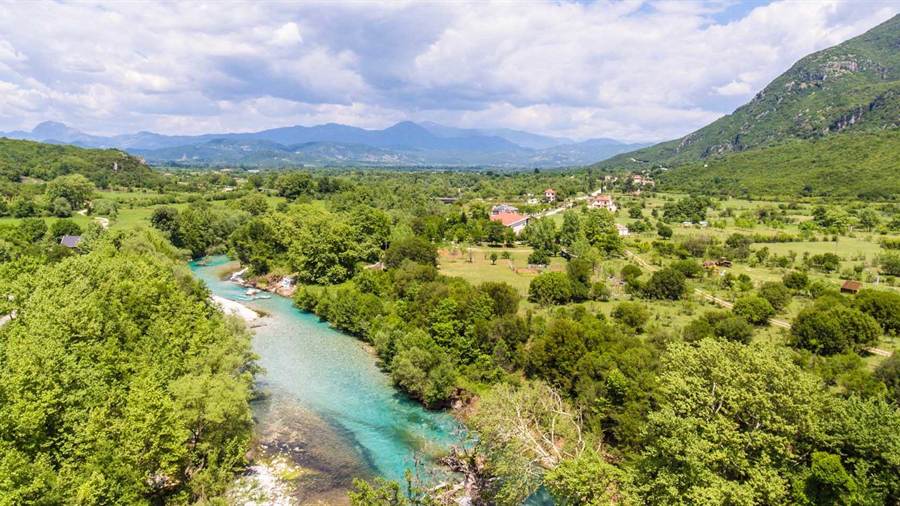
Konitsa serves the small villages of the Pindos as their local centre. The town holds shops, schools and a public medical centre, and farming and tourism drive its economy.
The villages around the town are known as the Konitsochoria, which means the villages of Konitsa. In Albanian the town is Konicë, in Aromanian Cunitsã and in Turkish Koniçe.
Three theories explain the name. One links it to Knossos, an ancient Epirote city near the site. Another reads a Slavic word for horseland, and a third points to a lord named Konis and his castle.
A Konitsa tour also passes close to sites in the wider area. The Tymfi mountains supply the Vikos spring water brand, and the sulfur baths of Kavasila lie among the attractions near the town.
Since the 2011 local government reform, the municipality of Konitsa joins five former municipalities: Konitsa, Aetomilitsa, Distrato, Fourka and Mastorochoria. Together they cover 951.184 km2 of mountain land.
- Province: The former province of Konitsa matched the present municipality and was abolished in 2006.
- Community: The Konitsa community itself covers 54.506 km2.
- Benefactor: Panagiotis Chatzinikou, a merchant and benefactor from Konitsa, lived from 1707 to 1796.
- Writer: Faik Konica, an Albanian writer and linguist from Konitsa, later served as ambassador of Albania in Washington, DC.
A Konitsa tour starts from this base, and the next section sets out the formats currently on sale, from the cliff routes to the river trips.

Which Konitsa tour formats are on sale?
A Konitsa tour on sale comes in six listings across two catalogues: a via ferrata climb, a day from Thessaloniki to the house of Saint Paisios with Ioannina, a private Ice Age trail walk by the Voidomatis, and three rafting trips.
The first format is a via ferrata climb based in Konitsa itself. The listing presents it as a full via ferrata experience, the only climbing product among the formats now on sale.
A second listing starts in Thessaloniki. It visits the house of Saint Paisios in Konitsa and adds a stop in Ioannina, so a Konitsa tour of this kind links two cities of northern Greece.
A third format is a private walk along a path beside the Voidomatis river. Its title calls the route an Ice Age trail and places it in the region of Epirus.
Three listings sell rafting on the Voidomatis. One adds photos of the trip, a second describes an easy rafting experience, and a third places the river in the Zagori area.
No listing on sale names the Aoos as a rafting river. Every water format in the catalogues points to the Voidomatis, while the land formats cover the cliffs, the river path and the saint’s house.
- Climbing: One listing offers a via ferrata route in Konitsa.
- Thessaloniki day: One listing leaves Thessaloniki for the house of Saint Paisios and Ioannina.
- River path: One private listing walks an Ice Age trail beside the Voidomatis.
- Rafting: Three listings across both catalogues run rafting trips on the Voidomatis.
The tour cards and availability boxes on this page list live dates for each Konitsa tour format, from the via ferrata to the rafting trips on the Voidomatis.
Where is Konitsa on a Konitsa tour?
A Konitsa tour reaches the north of Epirus, in the Ioannina regional unit, where the town rises in an amphitheatre on a slope of the Pindos range. It overlooks a river valley, with the Albanian border close by.
The town stands north of Ioannina and northeast of the Zagorochoria, the village group of Zagori. Records of the civil war place it 8 miles from the Albanian border.
Greek National Road 20 links Kozani, Konitsa and Ioannina. A Konitsa tour by road from Ioannina follows this route north, and the same road passes to the west of Mount Smolikas.
Mount Tymfi rises to the southeast, since Konitsa is the nearest town on its northwest side. The EO20 road runs close to the western, northwestern and northern sides of that massif.
Further north, the Gramos chain runs along the boundary of the Ioannina and Kastoria regional units. Smolikas lies to its south, and the Voio range lies to its east.
The upper part of the town is its oldest quarter and holds the larger population, while the lower part is newer and less populated. A Konitsa tour on foot crosses both levels of the slope.
- Pyrsogianni: This village lies 20 km northeast of Konitsa and 60 km north of Ioannina.
- Plikati: One of the northernmost villages of Epirus, it lies 28 km north of Konitsa.
- Tymfi paths: Trails to Mount Tymfi also leave from Konitsa, marked mainly by red paint dots on rocks.
- Two quarters: In the Ottoman period Christians formed the majority in the upper part of Konitsa, and Muslims in the lower part.
A Konitsa tour from the south passes through the regional capital, and an Ioannina tour covers that city before the road climbs north.
What history does a Konitsa tour cover?
A Konitsa tour covers a history that runs from Proto-Greek settlers of the Middle Bronze Age to Molossian forts, a castle named in 1380, Ottoman rule from the 15th century, the 1923 exchange and the civil war attack of 1947.
Proto-Greek populations lived in the area during the Middle Bronze Age, between 2100 and 1900 BC. In classical antiquity the land belonged to the Molossians, and forts guarded key points under Pyrrhus of Epirus.
At Liatovouni, in the valley of Konitsa, a Molossian settlement dates from the 13th to 12th century BC. Its cemetery held 103 burials, and Mycenaean weapons lay in the earliest grave.
The modern name first appears in the Chronicle of Ioannina of 1380. It records that the local Despot of Epirus strengthened the castle of Konitsa against an expected attack.
Ottoman rule began in the 15th century, and Konitsa became the seat of a kaza. By the late 19th century the town held 7,000 people, 4,000 of them Christians.
Under the 1923 exchange between Greece and Turkey, about two-thirds of the Muslims left for Turkey in 1925. Around 1,000 Greeks from Cappadocia settled in their place.
- Schools: In 1906 the kaza of Konitsa counted 31 schools and 1,036 pupils.
- 1940: In early November 1940, units sent by Fascist Italy briefly occupied the town and looted shops.
- 1947: In December 1947 communist forces failed to take Konitsa as the capital of their provisional government, as the townspeople sided with the army.
- Dovas: Konstantinos Dovas, later Prime Minister of Greece, welcomed Queen Frederica to the town as a colonel during the battle.
A Konitsa tour that reaches the upper town walks through the oldest quarter, where this long record of settlers, refugees and defenders took shape.
Which stone bridges and stone crafts does a Konitsa tour show?
A Konitsa tour meets the stone single-arched bridges of the Aoos gorge, built between the 17th and 19th centuries, and the stone craft of the villages to the north, where builders and masons from the Konitsa area worked far from home.
These bridges stand in the northern part of the Vikos–Aoös National Park, very close to Konitsa. Monasteries built in the local architectural style share the gorge with them.
The bridge of Bourazani spans the Aoos. In the civil war battle, communist forces attacked it to separate government troops in Ioannina from the town, and the government flew troops in aboard DC-3 aircraft.
Stone craft also came from the villages of the municipality. Men from Gorgopotamos and Chionades, in the Konitsa area, worked as masons or painters in Zagori, though they rarely settled there.
In Pyrsogianni, the Ethnological Museum of Stonemasons occupies the ground floor of the old stone school, built in 1927. The stone church of Agios Georgios, with its bell tower, stands in the same village.
The men of Plikati worked as builders. They left in the winter months for towns in the lowlands, and in the 1960s builders from the village worked in Germany.
- Gorge walls: The southern side of the Aoos gorge is steeper than its northern side.
- Gullies: Secondary gullies and currents cut the gorge in large numbers.
- Village houses: Plikati keeps stone houses with slate roofs, two or three storeys high.
- Debris: Steep ravines carry material from weathered limestone down into the Aoos.
A Konitsa tour that follows these bridges and villages reads the work of local stone builders across the gorge and the slopes to the north.
What does a Konitsa tour see along the Aoos?
A Konitsa tour along the Aoos follows a river valley that served for millennia as a natural route from inland Epirus to southern Illyria and the Adriatic, and reaches the monastery of Panagia Molyvdoskepastos near the Greek–Albanian border.
Ancient writers gave the river different names. Hecataeus called it Aias, Plutarch used Anios, and Polybius, Livy and Strabo wrote Aoos. Stephanus of Byzantium listed Avos, and older Greek texts call it Voioussa.
In 274 BC Pyrrhus of Epirus defeated Antigonus II Gonatas near the banks of the river. A Thesprotian tribe, the Parauaioi, took its name from the river, as the people living beside it.
The monastery stands 400 metres from the point where the Aoos meets the Sarantaporos, at the foot of Mount Meropi-Nemertsika. It lies 20 km from Konitsa and 55 km from Ioannina.
An inscription of 1561 credits its founding in the 7th century to Emperor Constantine Pogonatos. The present catholicon, the main church, dates from the 13th or 14th century.
In the 14th century a school for scribes taught monks and lay people to copy manuscripts. The monastery was left without monks after 1913, and bombing in 1943 almost razed it.
- Village: Molyvdoskepastos, meaning lead-covered, was called Depalitsa before 1929.
- Frescoes: The oldest wall paintings in the catholicon date from the start of the 14th century.
- Later layer: Eustathios Iakovou from Arta painted the church anew after damage in 1537.
- Birthplace: The village is the birthplace of the former Greek President Karolos Papoulias.
A Konitsa tour downstream along the Aoos reaches this monastery, close to the point where the river enters Albania and the Sarantaporos joins it.
Why does a Konitsa tour mention Paisios?
A Konitsa tour mentions Paisios because the monk, venerated by Orthodox Christians as Saint Paisios of Mount Athos, spent his childhood in Konitsa after his family left Pharasa in Cappadocia, and one listing on sale visits his house in the town.
He was born Arsenios Eznepides on 7 August 1924 in Pharasa, shortly before the population exchange between Greece and Turkey. Tradition holds that Arsenios the Cappadocian, who baptised him, foretold a monastic future.
After the exchange, the Eznepides family settled in Konitsa, where Arsenios grew up. On leaving intermediate public school he trained in carpentry, and his uncle Prodromos taught him Byzantine chant.
In 1945 he joined the Hellenic Army and served as a radio operator. In 2017 the Holy Synod of the Church of Greece named him patron saint of the military communications corps.
After his service he went to Mount Athos in 1950. He took the name Paisios at Philotheou monastery in 1957, in honour of Paisios II, a metropolitan of Caesarea born in Pharasa.
He died on 12 July 1994 and lies buried at the monastery of Saint John the Theologian in Souroti, near Thessaloniki. The Ecumenical Patriarchate canonised him on 13 January 2015.
- Family years: A biographical series shows him back in Konitsa for three years for family reasons, before he left for Athos for good in March 1953.
- Filming: That series, Saint Paisios, From Pharasa to Heaven, was filmed in places he lived, among them Konitsa, Mount Sinai and Mount Athos.
- Feast day: The church marks his feast on 12 July in the new calendar.
- Monastery link: Monks returned to the Molyvdoskepastos monastery in 1988 with his encouragement.
A Konitsa tour from Thessaloniki links both ends of his life, since Souroti lies just outside that city and the listing on sale visits his house in Konitsa.
Which rivers and rafting fit a Konitsa tour?
A Konitsa tour on the water centres on the Voidomatis, the river named in all three rafting listings and in the Ice Age trail walk, while the Aoos and the Sarantaporos frame the wider river network around the town.
Kleidonia, a village and community in the municipality of Konitsa, sits on the right bank of the Voidomatis. National Road 20 passes through Kalyvia, the other village of the community.
The Ice Age walk fits the record of the Voidomatis basin. Material from de-glaciation and heavy runoff from the uplands, about 20,000 years ago, forms the middle layer of its river deposits.
The final glacial phase in the basin is placed in the Last Glacial Maximum, between 22,000 and 20,000 years ago. A Konitsa tour on the river path walks through land shaped by that ice.
Rafting has grown as an adventure sport since the 1950s. Certain river sections count as an extreme sport, while other sections are less difficult, a contrast that matches the listing for an easy rafting experience.
The Sarantaporos runs 50 km and joins the Aoos as a right tributary. Its last 10 km or so form the Greek–Albanian border, and it crosses the Mastorochoria and Konitsa units.
- Sarantaporos source: The river rises between the Gramos and Voio ranges in the Kastoria regional unit.
- Basin: The Sarantaporos drains a basin of 870 km2.
- Ancient sharks: Pausanias mentioned sharks in the Aoos where it flows through Thesprotia.
- Equipment: Modern rafts use nylon or Kevlar-infused plastics such as PVC or urethane.
A Konitsa tour on the Voidomatis touches waters that also run through the gorge country to the south, covered in the post on Zagori tours.
Which mountain sports suit a Konitsa tour?
A Konitsa tour for mountain sports combines the via ferrata on sale in Konitsa with rock climbing on Mount Tymfi, hill walks on Smolikas and visits to the high villages of Gramos and the Mastorochoria, north of the town.
A via ferrata, Italian for iron path, is a protected climbing route. Steel cables, rungs or ladders are fixed to the rock, and climbers clip a harness with two leashes to them.
Such routes date back to the 19th century and are linked with the First World War, when they were built in the Dolomites to move troops. Over 1,000 now exist in the European Alps.
Mount Tymfi saw its first recorded climb on 7 and 8 June 1956, when Giorgos Michailidis and Giorgos Xanthopoulos climbed the face of Gamila. The northeastern face of Gamila now counts 8 routes.
Smolikas is built of ophiolite rocks. Grassland and rock cover it above 2,000 metres, with deciduous and conifer forest below. Its villages include Agia Paraskevi to the north and Armata to the south.
On Gramos, Aetomilitsa stands at 1,430 metres, one of the highest communities in Greece, and a glacial lake, Moutsalia, lies 5 km away as the crow flies. Plikati sits at 1,240 metres.
- Mastorochoria: This municipal unit covers 271.160 km2 and had 851 residents in 2021.
- Seat: Pyrsogianni, on the right bank of the Sarantaporos, was the seat of the former Mastorochoria municipality.
- More routes: The Gamila II face counts 6 climbing routes, and Tsouka Rossa counts 19.
- Birds: The Hellenic Ornithological Society names Tymfi and Smolikas as key breeding areas for birds of prey and alpine species.
A Konitsa tour in the high Pindus pairs with other mountain trips in Epirus, and a Metsovo tour covers another town of the same range.
What do travellers ask about a Konitsa tour?
A Konitsa tour raises four recurring questions: whether rafting is on sale, how to reach the town from Thessaloniki, what the via ferrata involves and which monastery lies near the town. The answers draw on current listings and on the published sources.
Is rafting part of a Konitsa tour?
Yes. Three listings on sale offer rafting on the Voidomatis, the tributary of the Aoos that flows past Kleidonia in the municipality of Konitsa. One adds photos of the trip, one is sold as an easy rafting experience, and one places the river in the Zagori area.
Can a Konitsa tour start from Thessaloniki?
Yes. One listing leaves Thessaloniki for the house of Saint Paisios in Konitsa and adds a visit to Ioannina. Paisios grew up in Konitsa after his family left Cappadocia, and he is buried at the monastery of Saint John the Theologian in Souroti, just outside Thessaloniki.
What does the via ferrata on a Konitsa tour involve?
It is a climbing route on fixed steel cables, rungs or ladders. These fixtures let climbers pass dangerous ground without technical climbing equipment, and routes range from exposed paths to steep, strenuous climbs. One listing on sale offers the experience in Konitsa.
Which monastery lies near a Konitsa tour route?
The Greek Orthodox monastery of Panagia Molyvdoskepastos lies 20 km from Konitsa, close to the Greek–Albanian border. Its catholicon holds frescoes in up to three layers, one Byzantine and two post-Byzantine, and a brotherhood has lived there again since 1988.