

Lake Doxa is a mountain lake on the Feneos plateau in Corinthia, in the north-east Peloponnese, set below the peaks of Ziria, with a chapel on its shore, ancient Pheneus nearby and Lake Stymphalia over the hills. The trip is one of the Greece Tours on Greece Ville, listed with the other Peloponnese tours.
This post covers the day trips on sale, where the lake lies, how it was made, what stands on its shore, ancient Pheneus, the mountain above it, Lake Stymphalia and the questions that come up before booking.
What is Lake Doxa?
Lake Doxa is an artificial lake in western Corinthia, in the Peloponnese of southern Greece. It lies at an elevation of 900 m in the Feneos municipal unit, close to the village of Archaia Feneos, and oak and pine forest rings it.
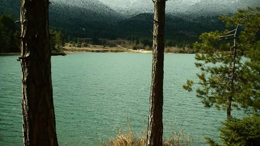
The lake is a man-made body of water rather than a natural basin. Work on the lake was completed in the late 1990s, which makes it a recent addition to a landscape of plains and mountains.
A small river, also named Doxa, both feeds and drains the lake. Past the lake the river carries on and empties into the plain of Feneos. The reservoir thus sits upstream of the cultivated plain.
Corinthia has hot summers and mild winters along its coast, but its mountain areas see colder winters with snowfalls. Lake Doxa, at 900 m, belongs to that colder upland zone of the regional unit.
The lake belongs to Feneos, a village and former municipality. Since the 2011 local government reform, Feneos has been a municipal unit of Sikyona, covering 226.201 km2 with 1,327 residents in 2021.
The name Feneos comes from the ancient city of Pheneus. In ancient times the area counted as part of Arcadia, although Lake Doxa and its valley now fall inside the regional unit of Corinthia.
- Type: Lake Doxa is a reservoir created by people, not a lake formed by nature.
- Height: The surface of the water lies at an elevation of 900 m above sea level.
- Water: The small river Doxa flows into the lake and also carries its water out again.
- Location: The lake lies in western Corinthia, near the village of Archaia Feneos.
Lake Doxa combines a modern reservoir with a valley full of myth and ancient roads. The sections below cover its formats, location, origin, shore, ancient past, mountain and nearest neighbour lake.

Which Lake Doxa day trips are on sale?
Lake Doxa appears in two private formats on sale. One catalogue lists a day trip from Athens that pairs the Ziria plateau with the lake. A second catalogue lists an adventure format from Nafplio and Argos that adds Nemea and Feneos.
The Athens listing is a private day trip for one booking party. Its title names two places, the Ziria plateau and Lake Doxa, and the mountain and the lake form the core of the outing.
Ziria is an alternative name for Mount Kyllini. Feneos lies at the foot of that mountain, so the plateau in the Athens title and Lake Doxa belong to the same upland block of Corinthia.
The second format starts from Nafplio and Argos. Its title calls the outing a private adventure and lists three stops: Nemea, Feneos and Doxa lake, the form of the name used in that listing.
Nemea and Feneos both lie in Corinthia, and Feneos is the municipal unit that holds Lake Doxa. The Nafplio route therefore links two parts of the same regional unit on one trip.
No other format in the two catalogues checked names the lake. Both listings are private, so neither a shared coach seat nor an open group departure is on sale for the lake at present.
- From Athens: A private day trip pairs the Ziria plateau with Lake Doxa in a single outing.
- From Nafplio: A private adventure format starts from Nafplio and Argos rather than from Athens.
- Stops: The Nafplio title names Nemea, Feneos and the lake as its three stops.
- Group type: Both formats are private, and no shared group departure is listed for the lake.
The tour cards and availability boxes on this page list live dates for each format, from the Athens day trip to the private Lake Doxa adventure from Nafplio.
Where is Lake Doxa?
Lake Doxa sits in the Feneos municipal unit of Corinthia, on the upland plain west of Mount Kyllini, also called Ziria. Feneos forms part of the municipality of Sikyona, whose seat is Kiato, and the regional unit lies in the north-east Peloponnese.
Corinthia is a regional unit of the Peloponnese region. It spreads around the city of Corinth in the north-eastern part of the peninsula, while Lake Doxa lies in the western part of the unit.
Corinthia borders Achaea to the west and south-west and Arcadia to the south-west. Argolis lies to the south, the Gulf of Corinth and Attica to the north, and the Saronic Gulf to the east.
Feneos belongs to Sikyona, a municipality formed in the 2011 reform by merging Feneos, Sikyona and Stymfalia. The enlarged municipality covers 602.539 km2, and its seat is the town of Kiato.
In antiquity the valley formed the territory of Pheneus. Mountains shut it in on every side, offshoots of Cyllene and the Aroanian chain, and it measured about 12 km long and as wide.
Goura, the former seat of Feneos, stands at 950 metres on the western slopes of Mount Zireia, in the valley of the river Olvios. It lies 91 kilometres south-west of the city of Corinth.
- Region: Lake Doxa lies in the Peloponnese region, on the peninsula of the same name in southern Greece.
- Regional unit: The lake sits in Corinthia, in the western part of the unit.
- Municipality: Sikyona holds the lake, and the town of Kiato serves as its seat.
- Nearest village: Archaia Feneos lies close to the lake in the Feneos municipal unit.
Lake Doxa shares Corinthia with the archaeological sites of Nemea, Sicyon and the Heraion of Perachora, and a Nemea wine tour heads to the first of those areas.
How was Lake Doxa made?
Lake Doxa was made by people, not by nature. Construction ended in the late 1990s, and the small river Doxa both feeds and drains the water. The site lies upstream of a plain with a long record of floods and underground outlets.
Below Lake Doxa the river runs on into the plain of Feneos. In antiquity two streams from the northern mountains met in the valley, and the joined river bore the names Olbius and Aroanius.
The plain has no opening through the mountains to the south. Instead its water drains through underground channels called katavothra in the limestone and reappears as the sources of the river Ladon.
The Ladon is a 70 km river of the Peloponnese and a tributary of the Alfeios, which empties into the Ionian Sea. Water from the Feneos plain thus ends up in the Ionian Sea.
Early inhabitants dug a canal 50 stadia long and 30 feet wide to lead the river to the katavothra. Tradition credited the work to Heracles, and Catullus wrote of an underground channel dug by Hercules.
The canal had fallen out of use by the time of Pausanias, and floods returned when the outlets blocked. Pliny the Elder counted five such disasters, and the Pheneatae said water once destroyed their city.
- Built: Construction of Lake Doxa ended in the late 1990s, making it a modern reservoir.
- Outlet: Underground katavothra carry the water of the plain towards the river Ladon.
- Flood of 1821: Blocked channels let the water drown 18 to 21 km2 of cultivated land.
- Reopening in 1832: The water burst into the Ladon and Alpheius and flooded the plain of Olympia.
Lake Doxa now stores river water above a plain that has flooded more than once since ancient times, while the old canal of Heracles survives only as traces in the valley.
What stands on the shore of Lake Doxa?
Lake Doxa holds a small church of Agios Fanourios on a little peninsula in the heart of the lake. The Saint George Monastery of Feneos stands on higher ground to the north, after a move from its earlier site, and forest lines the shore.
Phanourios, the saint of the lake chapel, is venerated by both the Eastern Orthodox Church and the Roman Catholic Church. His feast falls on August 27, and his Greek name means the revealer.
The life of Phanourios is known only through icons discovered on Rhodes in the 16th century. His icons show a soldier from that island, and veneration of him later spread to Cyprus and then Greece.
Orthodox tradition holds that Saint Phanourios helps people find their lost belongings. Eastern Orthodox Christians bake a lenten cake called Fanouropita on his feast day as thanks for his help.
The Saint George Monastery in Feneos was relocated to higher ground, and its present site lies north of Lake Doxa. Oak and pine forest surrounds the lake below the monastery.
The monastery has a place in modern history. During the Greek Civil War, Communist guerrillas turned the monastery of St George into a concentration camp and killing ground, and hundreds are believed to have died there.
- Chapel: The church of Agios Fanourios stands on a small peninsula in the middle of the lake.
- Feast: The feast of Phanourios falls on August 27 in the church calendar.
- Monastery: Saint George now stands on higher ground to the north of the water.
- Forest: Oak and pine woods surround the lake and frame its shoreline.
The chapel on its peninsula and the monastery above the north shore are the two landmarks recorded at Lake Doxa, one on the water and one on the hill above it.
What ancient history lies near Lake Doxa?
Lake Doxa lies near the remains of ancient Pheneus, a town in the north-east of ancient Arcadia. The ruins stand on a hill whose lower slope now holds Archaia Feneos, formerly Kalyvia, the village next to the lake.
Homer names Pheneus in the Catalogue of Ships in the Iliad, where Agapenor leads its troops. The town won more fame in myth than in recorded history, and Virgil makes it the home of Evander.
In the Aeneid, Evander recalls a visit to Feneos by Anchises, the father of Aeneas. That memory is one reason he allies his Arcadian settlers with the Trojans, according to the poem.
Pausanias found the city in decay. Its acropolis held a ruined temple of Athena Tritonia with a bronze Poseidon Hippius, and a nearby hill held the tomb of Iphicles, brother of Heracles.
Hermes was the principal deity of Pheneus and had his own temple in the city. The town honoured him with games called the Hermaia, held as an annual festival.
William Martin Leake judged that the whole hill formed the acropolis, with the lower town on the plain below. The fit with Pausanias is imperfect, and the exact layout of the city remains an open question.
- North road: A temple of Apollo Pythius stood beside the road to Achaea, 15 stadia from the city.
- Styx: Herodotus placed the source of the river Styx near Feneos.
- West road: The road to Cleitor first ran along the canal of Heracles and then crossed a mountain.
- South road: The route to Orchomenus passed through a narrow ravine to the village of Caryae.
Ancient Corinth with its acropolis is a notable attraction of Corinthia, and an Ancient Corinth tour adds that site to the ancient story of Lake Doxa and Pheneus.
Which mountain rises above Lake Doxa?
Lake Doxa lies below Mount Kyllini, known as Mount Ziria, which rises to 2,376 m above sea level. The mountain stands wholly inside modern Corinthia, near the line between Arcadia and Achaea, and in Greek myth it is the birthplace of Hermes.
Much of the mountain is bare rock, but the zone below 2,000 m is largely forested. A park covers a large share of the massif, so roads keep near its southern and western slopes.
From the summit the view takes in eastern Achaea, the Gulf of Corinth and the greater part of Corinthia. The nearest ranges are Oligyrtos to the south and Chelmos and Aroania to the west.
In Greek myth, Hermes, son of Zeus and Maia, was born in a sacred cave on the mountain. His epithet Cyllenius comes from the mountain, and the Pleiades were born on Kyllini too.
A temple of Hermes once crowned the summit. Pausanias saw it in ruins, its statue of juniper wood standing about eight feet high. Tradition credits Lycaon with the first temple to Hermes.
Trikala comprises three settlements, Upper, Middle and Lower Trikala, on the flanks of Kyllini. The village belongs to Xylokastro and draws visitors for its natural setting and its nearness to Athens.
- Height: Kyllini rises to 2,376 m, or 7,795 ft, above the level of the sea.
- Names: Kyllini, Cyllene and Ziria all refer to the same mountain above Lake Doxa.
- Observatory: An observatory stands on the mountain at a height of 908 m.
- Boundary: The line between Stymfalia-Feneos-Evrostini and Xylokastro runs across the massif.
Chelmos and Aroania close the view west of Lake Doxa, and a Kalavryta tour explores the slopes on that side of the northern Peloponnese.
What is Lake Stymphalia near Lake Doxa?
Lake Doxa has a larger neighbour in Lake Stymphalia, a closed karst basin in Corinthia with a wetland and farmland. Corinthia counts it as its largest lake, a bird resort protected by Natura 2000, and Greek myth sets the Stymphalian birds there.
The lake is an important stopover for migratory birds, and its size changes with the seasons. The area is rich in birds, amphibians and plant life, and weasels are seen there too.
The lake lies in the Stymfalia municipal unit of Sikyona, home to 1,898 people in 2021. The unit fills a mountain valley with an average altitude of 600 metres.
Ancient Stymphalos stood on the north shore. Excavations led by Hector Williams for the University of British Columbia have run there since 1982, revealing a town refounded in the 4th century BC on a grid plan.
In Greek myth, the Stymphalian birds were man-eating creatures with bronze beaks, metal feathers they hurled at victims and poisonous dung. They had fled a pack of wolves to a marsh in Arcadia.
Their defeat was the sixth labour of Heracles. Athena gave him a rattle made by Hephaestus, and he shook it on a mountain above the lake, then shot the startled birds with arrows.
- Ancient city: Digs at Stymphalos found a theatre, a palaestra, a fountain house and temples.
- Goddess: Artemis ranked as the chief divinity of the ancient town of Stymphalos.
- Myth variant: One version of the story discounts the labour because Athena helped Heracles.
- Survivors: The birds that escaped settled on the island of Aretias in the Euxine Sea.
Lake Stymphalia and Lake Doxa both lie in the municipality of Sikyona, and in antiquity a road over Mount Geronteium linked Pheneus with Stymphalus between the two basins.
What do travellers ask about Lake Doxa?
Lake Doxa raises four common questions from travellers: whether the lake is natural, how high it sits, which saint the chapel honours and which formats on sale reach it. The short answers below repeat the key facts from the sections above.
Is Lake Doxa a natural lake?
No. Lake Doxa is an artificial lake, and its construction was completed in the late 1990s. The small river Doxa both feeds and drains it, then flows on into the plain of Feneos. That plain drains through underground katavothra in the limestone, which carry its water to the sources of the river Ladon.
How high is Lake Doxa?
Lake Doxa lies at an elevation of 900 m. Goura, the former seat of Feneos, stands a little higher at 950 metres on the western slopes of Mount Zireia. The Stymfalia valley to the east averages 600 metres, and the summit of Mount Kyllini reaches 2,376 m.
What is the church in Lake Doxa?
The church in Lake Doxa is a small chapel of Agios Fanourios on a little peninsula in the heart of the lake. Phanourios is venerated by the Eastern Orthodox and Roman Catholic Churches, with a feast on August 27. Tradition links him with finding lost belongings, and believers bake Fanouropita in his honour.
Which formats on sale include Lake Doxa?
Two private formats include Lake Doxa. One is a day trip from Athens that names the Ziria plateau and the lake. The other is a private adventure from Nafplio and Argos that also stops at Nemea and Feneos. The tour cards and availability boxes on this page show live dates for both.