

A Pelion tour crosses Mount Pelion, the green mountain and peninsula above Volos in Magnesia, from the stone mansions of Makrinitsa and Portaria to the east-coast villages of Zagora and Tsagarada, the little train of Milies and the bays of the Aegean shore. The tour is one of the Greece Tours on Greece Ville.
This post covers the formats on sale, where Pelion lies, Volos, Makrinitsa, Portaria and Hania, the little train, Zagora, Tsagarada, Kissos and Mouresi, the east-coast bays, Vyzitsa and Pinakates, South Pelion, the village architecture, the Centaurs and Chiron, the Argonauts, the prehistory near Volos, the forests, local products, modern history and the questions that come up before booking.
What is a Pelion tour?
A Pelion tour is a day trip from Volos onto Mount Pelion, the mountain that forms a hooked peninsula in Thessaly. The route links hill villages above the Pagasetic Gulf, with stops at village squares, a folk museum, viewpoints and a mountain railway.
Pelion is a mountain in the southeastern part of Thessaly. A Pelion tour treats it as one district of slopes, villages and coast, with the port city of Volos as the start point.
Visitors come to the mountain in every season. Pelion draws tourists throughout the year, and the wider Magnesia regional unit around it hosts two million tourists annually, with Volos as its capital.
Pelion holds twenty-six villages. A Pelion tour picks a handful of them, matched to the format and the season, and links them by the roads that climb from the gulf shore.
Modern services reached the slopes late. Electricity, radio and cars first arrived in the 1950s, except in Volos, which had them earlier. Television followed in the 1970s and 1980s, and the internet in the late 1990s.
The mountain also appears in English literature. Shakespeare named Pelion in The Merry Wives of Windsor and again in Hamlet, and Herman Melville used its myths in Book XXV of his novel Pierre.
- Start: Volos, the capital of Magnesia, is the start point of a Pelion tour.
- Region: The mountain lies in the southeastern part of Thessaly.
- Railway: The Pelion railway was the first serious public investment in the area.
- Villages: Makrinitsa and Portaria both belong to the municipality of Volos.
The sections below follow the order of the day on a Pelion tour: the mountain itself, the Volos start, Makrinitsa, Portaria, the high slopes and the little train to Milies.

Which Pelion tour formats are on sale?
A Pelion tour is sold in seven listed formats. Five start in Volos, one names only the mountain and one starts in Thessaloniki. Private village days, a swim day, east and south days and a myth theme make up the range.
Two Pelion tour formats run as private days. One leaves Volos for the villages and adds an olive oil experience. The other heads to the south of the peninsula and includes a wine tasting.
A village tour from Volos adds a swim and a lunch to the day. The format mixes stops in the mountain villages with a break by the sea, inside one outing from the city.
A separate format from Volos crosses to the eastern side of Pelion, where the mountain meets the Aegean Sea. Its title names two villages on that side of the mountain, away from the gulf.
One Pelion tour joins traditional villages with the myths of the mountain under a mountain escape theme. A further village tour from Volos visits Milies and two other villages of the same municipal unit.
The Thessaloniki format is a private day trip that covers both Volos and Pelion in one outing. It adds the road south from the northern city at the start and the return drive at the end.
- Private: Two formats run as private days, one with olive oil and one with wine.
- Swim: One village tour from Volos adds a swim and a lunch.
- Theme: One format pairs traditional villages with mountain myths.
- Long range: One private day trip starts in Thessaloniki.
The tour cards and availability boxes on this page list live dates for each Pelion tour format, while a Meteora day trip from Thessaloniki is a separate inland outing.
Where is Pelion on a Pelion tour?
A Pelion tour climbs a mountain in the southeastern part of Thessaly that forms a hooked peninsula in Magnesia, between the Pagasetic Gulf and the Aegean Sea. Its highest summit, Pourianos Stavros, reaches 1,624 metres above sea level.
Pourianos Stavros also carries the name Xeforti. Below it, the slopes run down to the gulf shore at Volos on one side and to the open Aegean Sea on the other side of the peninsula.
The mountain belongs to the Magnesia regional unit, part of the region of Thessaly. Volos is the capital of the unit, and about 70% of the people of Magnesia live in the Greater Volos area.
The Pelion range wraps around the Pagasetic Gulf on its east and south sides. The gulf is rounded in shape and opens to the Euboic Sea through a narrow channel about 4 km wide.
Two national roads cross the peninsula. On a Pelion tour, the EO34 serves the southern portion and the EO34a runs through the middle, while provincial roads link Milies to the EO34.
A panorama from Pelion takes in Mount Olympus, the plain of Thessaly, Euboea and the northern Sporades islands. When the air holds little humidity, the mountains of Agio Oros come into view as well.
- Summit: Pourianos Stavros, the highest point, stands at 1,624 metres.
- Shape: The mountain forms a hook between the Pagasetic Gulf and the Aegean Sea.
- Neighbour: Mount Mavrovouni, at 1,054 metres, is the northeasternmost mountain of Magnesia.
- Rivers: Water from Pelion feeds the Anavros, Platanorema and Xirias rivers.
Those coordinates shape the day: a Pelion tour climbs from the gulf shore at Volos, then follows slopes that look back over the water toward the city and the islands beyond.
Why does a Pelion tour start in Volos?
A Pelion tour starts in Volos because the city stands at the foot of the mountain, at the innermost point of the Pagasetic Gulf. Volos is the capital of Magnesia and holds the road, rail and ferry links for the area.
Volos lies midway along the Greek mainland, about 170 kilometres north of Athens and 140 kilometres south of Thessaloniki. That position lets a Pelion tour start there from either the north or the south.
The city spreads over a plain on the foothills of Pelion, with the town of Agria on its eastern edge. Under Ottoman rule, the local Christian population moved up to the slopes of the mountain.
With 85,803 residents in 2021, Volos is the administrative centre of the Magnesia regional unit. It is also the only outlet to the sea for Thessaly, the largest agricultural region in Greece.
Road and rail meet here as well. The E75 motorway links Volos with northern and southern Greece, and direct trains run to Athens once a day, to Thessaloniki twice and to Larissa 15 times.
The new port dates from 1893 and now ranks as the third-largest cargo port in Greece. Ferries and flying dolphins leave daily for Skiathos, Skopelos and Alonissos, the Magnesia islands of the Sporades.
- Municipality: Makrinitsa, Portaria and Agria have formed municipal units of Volos since the 2011 reform.
- Climate: Pelion shields Volos from north-easterly winds, so the city gets less rain than the eastern side of the mountain.
- Railway: The Pelion railway once ran from Volos station through the city centre as a tramway.
- Greece: Volos joined the Greek Kingdom in November 1881 with the rest of Thessaly.
Ferries from the same harbour serve the Sporades, and that sea route to the islands belongs to a separate Skiathos boat trip rather than to a Pelion tour on the mountain.
What is Makrinitsa on a Pelion tour?
A Pelion tour stops at Makrinitsa, the village nicknamed the balcony of Mount Pelion. It stands in the northwestern part of the mountain, 6 km northeast of Volos, and houses the Museum of Folk Art and History of Pelion.
The name first appears in the early 13th century, through the Makrinitissa Monastery. Its root is Slavic: Mokrinitsa, a diminutive of Mokrina, meaning wet place, after the water around the village.
Greek speakers later changed the first vowel to a, from the Greek word makrys, meaning long. Makrinitissa is the more scholarly form, while Makrinitsa was the everyday name even in the 13th century.
Since the 2011 local government reform, Makrinitsa has formed a municipal unit of Volos. The unit covers 59.903 km2, and a Pelion tour reaches it on the road that climbs from the city.
The Museum of Folk Art and History of Pelion fills the Topali Mansion, an 1844 house just below the main square. The Topali family gave the building to the community of Makrinitsa in 1932.
The present museum has operated since 1994 and holds over 1,500 objects. Folk paintings, traditional costumes, a banner from the 1878 revolution and tools for spinning, weaving and distilling raki fill its rooms.
- Nickname: Makrinitsa carries the nickname balcony of Mount Pelion.
- Fresco: One traditional coffee house in the village has a fresco by the painter Theofilos.
- Monastery: The monastery of Saint Gerasimos stands in Makrinitsa.
- Season: The village is a popular destination, especially in winter.
A Pelion tour pairs Makrinitsa with Portaria, since both villages sit on the slopes above Volos and both have formed municipal units of the city since the 2011 reform.
What are Portaria and the ski slopes on a Pelion tour?
A Pelion tour reaches Portaria on the slopes north of Volos, facing the Pagasetic Gulf. The mountaintop of Pelion rises to the north of the village, and the higher elevations hold enough snow for ski facilities from Christmas to Easter.
Portaria stands on Mount Pelion, north of Volos and its suburbs, with its outlook over the Pagasetic Gulf. Since the 2011 reform, the village forms a municipal unit of Volos covering 22.754 km2.
Every year the main square of Portaria hosts a traditional wedding. People from Volos and the surrounding villages come up to watch and to learn how weddings once took place in these mountain communities.
Portaria is twinned with Tourtour, a sister city in France. On a Pelion tour, the village sits between the city below and the high ground to the north, where the mountaintop of Pelion stands.
Snow settles on the upper reaches of Pelion in winter, deep enough for ski facilities. The ski season runs from Christmas to Easter, so a winter Pelion tour can pair village squares with snowy slopes.
Winter in Magnesia brings heavy snow to the mountains and freezing spells. The yearly average sits at 17 degrees Celsius, and August highs in the regional unit reach about 37 to 38 degrees.
- Position: Portaria faces the Pagasetic Gulf from the slopes north of Volos.
- Custom: A traditional wedding takes place in the main square every year.
- Snow: Ski facilities on the higher slopes operate from Christmas to Easter.
- Rain: Magnesia receives about 540 millimetres of rain a year on average.
A winter Pelion tour therefore works on two levels of the mountain: the village squares of Portaria and Makrinitsa, and the snow higher up toward the summit.
What is the little train on a Pelion tour?
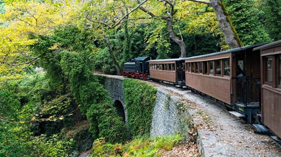
A Pelion tour that adds the little train rides the Pelion railway, a 600 mm narrow gauge line from Volos to Milies. Heritage trains now run the mountain section from Ano Lechonia to Milies, a village at 400 metres.
Thessaly Railways laid the line after it completed its metre gauge lines out of Volos. Limited space and mountainous terrain led the company to pick the narrower 600 mm gauge for the climb into Pelion.
The track reached Agria in 1892, Ano Lechonia in 1896 and Milies in 1903. Evaristo de Chirico, an Italian engineer, designed the line, and his son was the Metaphysical painter Giorgio de Chirico.
The mountain section from Ano Lechonia counts seven stone bridges, an iron bridge at Milies and two tunnels. Five stone road bridges also pass over the track as it climbs toward the terminus.
OSE suspended the service in 1971 as a cost-saving measure. In 1996 it reopened the Ano Lechonia to Milies section as a heritage railway, first with steam and with diesel traction from 1999.
Hellenic Train runs the heritage service on Saturdays, Sundays and public holidays from mid-April to the end of October. In July and August, a Pelion tour can catch the train on any day.
- Origins: Settlers fleeing pirate raids on Milies in Euboea founded the village inland, out of sight from the sea.
- School: Anthimos Gazis and Grigorios Konstantas opened the Psychis Akos school there in 1814, and it is now a library.
- Church: The church of Agios Taxiarchos in Milies dates from 1741.
- War: German troops burnt nearly the whole village on 4 October 1943 and executed 25 men.
The outward run on a Pelion tour finishes in Milies, 28 km from Volos, a village that looks out across the Pagasetic Gulf from the end of the line.
What is Zagora on a Pelion tour?
A Pelion tour that reaches Zagora visits the seat of the Zagora-Mouresi municipality, a role the village has held since the 2011 local government reform. Zagora is a commercial and tourist centre, split into four districts that match its four main churches.
On a Pelion tour, the name Zagora draws two explanations. One links it to a Greek term for an animal market, recalling a yearly fair where animals from as far as Mongolia and Madagascar changed hands.
The other reads Zagora as a Slavic word meaning behind the mountain. This reading fits the old habit of calling the villages on the eastern side of Pelion the villages of Zagora.
Greek ruins and coins point to settlement since the Homeric era, and the current name appears from the 13th century. Zagora’s port of Chorefto later built a large fleet, and silk trade grew.
Zagorian galleys reached West Africa, Brazil and Scandinavia. Under Sultan Mehmet IV, the area won privileges, and woollen and silk crafts thrived until the middle of the 19th century, while merchants settled in cities abroad.
The Public Historic Library, founded in 1762 by John Prigos, holds about 3,500 old and rare books, and its modern collection passes 10,000 books and magazines. Patriarch Callinicus IV was an early contributor.
- Oldest school: The school of Rigas Feraios, known as the Hellenic Museum, is the oldest school on Pelion.
- Girls’ school: The Kassavetio Girls’ School opened in the mid-1850s as the first girls’ school in Ottoman Thessaly.
- Revolution: In January 1878, Zagora was the seat of the revolutionary government of the insurgent regions, led by Jerome Kassavetis.
- Occupation: In January 1943, Italian forces bombed and raided Zagora, and residents were forced to leave for about a month.
A Pelion tour that stops in Zagora finds the library just north of Agios Georgios Church, near the main square, so the books, the church and the square form one compact stop.
What is Tsagarada on a Pelion tour?
A Pelion tour that stops in Tsagarada, also spelled Tsagkarada, reaches a village and community in the municipal unit of Mouresi. It stands at 408 metres on the eastern slope of the forested Pelion mountains, in the east of Magnesia.
Tsagarada served as the seat of the former municipality of Mouresi. After the 2011 reform, the Mouresi unit became part of the Zagora-Mouresi municipality, and Tsagarada stands as the largest village in that unit.
Tsagarada lies 1.5 km south-east of Mouresi, 3 km north of Xorychti and 9 km south-east of Zagora. On a Pelion tour, it sits between Mouresi and Xorychti.
The main square lies near the church of Agia Paraskevi, where a plane tree grows. It is said to be at least one thousand years old, and tradition counts it as possibly the oldest in Greece.
The Tsagarada community also includes the village of Mylopotamos. Both settlements sit within the Mouresi unit, which covers the north-eastern part of the peninsula on the Aegean Sea coast.
Further south, Xorychti stands at 420 metres and forms its own community together with Kato Xorychti. It lies 2 km north-west of Lampinou and 12 km south-east of Zagora, on the same eastern slope.
- Height: Tsagarada stands at 408 metres above sea level.
- Plane tree: The tree in the main square has a perimeter of nearly 20 metres.
- Population: The 2011 count recorded 525 residents, the highest figure in the Mouresi unit.
- Neighbour: Mouresi lies 1.5 km to the north-west, at a lower 310 metres.
A Pelion tour through Tsagarada treats the square and its plane tree as the main stop, then continues north-west to Mouresi or south to Xorychti.
What are Kissos and Mouresi on a Pelion tour?
A Pelion tour that visits Kissos and Mouresi stays on the eastern slopes above the Aegean coast. Kissos is a mountain village at about 500 metres, and Mouresi is a village and former municipality in the north-east of the peninsula.
Kissos lies 3 km from the Aegean Sea, 3 km west of Mouresi and 5 km south-east of Zagora. It belongs to the municipal unit of Mouresi, in the eastern part of Magnesia.
The church of Agia Marina, built in 1650 during Ottoman rule, stands in the main square. Its size and central site suggest that the Ottoman authorities gave permission for the building.
Frescoes and carved wooden iconostases decorate the interior. The village also hosts the Ecclesiastic Museum of Aghia Marina, which gives a Pelion tour a second reason to stop in Kissos.
Kissos was the original home of Kyriazis Hadji-Kyriazis, born in 1817. He founded a dynasty of tobacco merchants and producers that rose to prominence in Egypt under the name Kyriazi freres.
Mouresi lies at 310 metres, 1.5 km north-west of Tsagarada and 7 km south-east of Zagora. As a municipal unit of Zagora-Mouresi, it covers 54.214 square kilometres.
- Agios Dimitrios Piliou: This community includes Agios Dimitrios and the coastal village of Agios Ioannis.
- Anilio: The name means without sun, and the village sits at 296 metres, 2 km from the coast.
- Mouresi community: It takes in Mouresi, Agios Ioannis and Damouchari.
- Kissos: Kissos forms a community of its own within the Mouresi unit.
A Pelion tour that links Kissos and Mouresi moves from a 17th-century church to the village whose port, Damouchari, lies 4 km away on the coast.
Which east-coast bays does a Pelion tour reach?
A Pelion tour on the east coast reaches Damouchari, Agios Ioannis and Chorefto, three seaside settlements on the Aegean shore below the mountain villages. Damouchari serves as the port of Mouresi, while Chorefto is the port of Zagora.
Damouchari, also written Damouhari, sits on the Aegean coast at 46 metres. It lies 4 km from Mouresi and 25 km from Zagora, and it has grown from a fishing village into a summer destination.
The village has two bays. One is its natural harbour, and the other is the pebble beach called Palia Damouchari. The 2021 census recorded 33 inhabitants, which keeps the settlement small.
The village holds the ruins of a castle that the Byzantines built and the Venetians later used, dating to at least the 11th century. Nearby, Agios Nikolaos church dates to 1744, by its inscription.
On a Pelion tour further north, Agios Ioannis is a village and beach resort on the east coast, and it ranks among the more popular beaches of Pelion. A small port serves fishing boats and yachts.
Agios Ioannis belongs to the Agios Dimitrios Piliou community in the Zagora-Mouresi municipality. Agios Dimitrios stands 1 km to the south-west, at about 170 metres on the slope above the shore.
- Chorefto: This seaside resort lies east of Zagora and serves as its port.
- Roads: National roads EO34 and EO34a both head north from Zagora towards Chorefto.
- Film: In September 2007, scenes from Mamma Mia! were shot at Damouchari.
- Mylopotamos: This village belongs to the Tsagarada community within the Mouresi unit.
The same film used Kastani beach on Skopelos as its main location, so a Pelion tour that stops at Damouchari connects with a Skopelos boat trip.
What are Vyzitsa and Pinakates on a Pelion tour?
A Pelion tour that turns to the south-western slopes reaches Vyzitsa and Pinakates, two communities in the same municipal unit within South Pelion. Pinakates ranks among the best preserved of the 24 Pelion villages and is a category 1 protected landmark.
Pinakates lies on the south-western slopes of Pelion. It stands 3 km east of Agios Georgios Nileias and 3 km north of Kala Nera, a village on the Pagasetic coast whose name means good waters.
The first written mention appears in the Modern Geography of Greece by Daniil Filippidis and Grigorios Konstantas, printed in Vienna in 1791. At that time the village held about 100 houses, though it was older.
Population figures survive from the 19th century. In 1828 the village had 1,000 inhabitants, and by 1860 it counted 160 families with 800 residents. It joined Greece in 1881, when Thessaly was liberated.
Wine and oil production became the main industry, and olive cultivation lifted the local economy. Money from Greeks in Egypt also helped. A school opened in the early 20th century with 56 students.
On a Pelion tour, Pinakates shows how isolation kept its form intact. Until recently a single road reached the village and ended in its centre, while every other route served walkers or mules only.
- Benefactor: Ioannis G. Sarafopoulos, a business man from Pinakates, ranked among the main benefactors of the school.
- Low point: In the last decade of the previous century, only five families lived there in winter.
- Today: About 150 people live in Pinakates, while 350 names stand on the voting registers.
- Vyzitsa: The Vyzitsa community covers Vyzitsa and the settlement of Argyreika.
A Pelion tour on foot here follows the kalderimi, stone paths of South Pelion that date back centuries and were built for laden mules to pass each other.
What does South Pelion add to a Pelion tour?
A Pelion tour that heads south enters the South Pelion municipality, formed in the 2011 reform from five former municipalities and seated at Argalasti. It covers the southern part of the mountain, down to Trikeri at the westernmost point of the peninsula.
The municipality covers 368.539 square kilometres. Argalasti, its seat, stands on a fertile plateau and acts as a commercial and tourist centre, with its own municipal unit of 74.820 square kilometres.
Argalasti also works as a stopping point for beaches on two seas. Chorto, Kalamos and Lefokastro face the Pagasetic Gulf, while Potistika, Melani, Paltsi and Mikro face the Aegean Sea.
Pieces of ancient and medieval buildings are set into the walls of village buildings. Near the square, the church of the Holy Apostles Peter and Paul dates from 1886, and its marble bell tower from 1913.
On a Pelion tour along the gulf, Afissos, also written Afyssos, is the tourist centre of the Neochori community on the Pagasetic coast. Neochori itself stands above it at 480 metres in a pine forest.
The former municipality of Afetes takes its name from the ancient port of Aphetae. Before the Battle of Artemisium in 480 BC, the Persian fleet occupied the bay of Aphetae.
- Position: Trikeri lies at the westernmost point of the hook-like peninsula, on the Pagasetic Gulf.
- Population: The Trikeri municipal unit recorded 992 inhabitants in the 2021 census.
- Island: Palaio Trikeri covers about 2.5 square kilometres and has no cars or roads.
- Camp: From 1947 the island held female left-wing political prisoners, and by September 1949 the number held reached 4,700.
The Persian fleet at Aphetae ties a Pelion tour to the events of 480 BC, and a Thermopylae tour extends that story on the mainland.
What village architecture does a Pelion tour show?
A Pelion tour shows stone villages built on terraces, with houses of carved local slate and red clay. The 24 villages of modern Pelion keep this traditional style, from multi-storey homes with oriel fronts to large mansions known as arkhontika.
The stone comes as grey, blue or green slate, carved with skill and joined with red clay. In South Pelion, the village of Neochori is known for the slate from its quarries.
Pelian tradition sets out three levels. The ground floor holds work spaces for tools, cooking, storage, washing and weaving. The middle floor gathers the family in common rooms, and the top floor keeps the bedrooms.
Fireplaces heat the house, and their chimneys run through the walls to warm the upper levels. The top floor, with good airflow, stays cool in summer. Tall windows and painted decoration mark the oriel fronts.
Inside, builders used chestnut timber, stained dark brown and carved in detail. Among the larger mansions, the arkhontika or lordly mansions, a number now serve as small hotels and hostels.
On a Pelion tour, the Pelion Towers stand out as reference points for locals. These large stone buildings are 300 years old and combine building features of the mountain from the 17th, 18th and 19th centuries.
- Churches: In Zagora, Agia Kyriaki dates from 1740, Agios Georgios from 1765 and Agia Paraskevi from 1803.
- Squares: The central square of Neochori has centuries-old plane trees and a roofed fountain from 1807.
- Icon screen: Neochori’s Agios Dimitrios church, built in 1768, holds a carved wooden icon screen and wall paintings by the Epirote painter Pagonis.
- Zagora: The village keeps notable mansions and churches in the typical Pelion style.
A Pelion tour meets this architecture in village squares such as the one in Neochori, where church, fountain and plane trees stand among slate houses.
Why do Centaurs belong to a Pelion tour?
A Pelion tour enters the land that Greek myth gave to the Centaurs. Ancient stories placed these creatures, human above the waist and horse below, in the mountains of Thessaly, and they named the region of Magnesia and Mount Pelion as a chief home.
In one telling, the Centaurs were the children of Ixion and Nephele. Nephele was a cloud shaped in the likeness of Hera, part of a plot to expose the desire of Ixion before Zeus.
A second version traces the race to Centaurus, who mated with the Magnesian mares. His twin brother Lapithes became the ancestor of the Lapiths, a people of the Pineios valley and of Pelion itself.
The best-known clash is the Centauromachy. It broke out at the wedding of the Lapith king Pirithous to Hippodamia, when the Centaurs tried to carry off the bride and the other Lapith women.
Theseus, who happened to be at the feast, tipped the fight in favour of the Lapiths. After the battle, the defeated Centaurs were driven out of Thessaly towards the north-west, according to the myth.
- Homeland: Myths placed the Centaurs in Magnesia and on Mount Pelion, and also in the Foloi oak forest of Elis.
- Origin theory: A common view holds that people who did not ride saw mounted nomads as half man and half animal.
- Horse riding: Greek writers named the Lapiths of Thessaly as the inventors of horse riding and of the bridle bit.
- Horse breeds: Thessalian tribes claimed that their horse breeds descended from the Centaurs.
Volos sits at the foot of Pelion, a mountain that one account of the city calls the land of the Centaurs. A Pelion tour therefore starts on ground that myth tied to these figures.
Who was Chiron on a Pelion tour?
A Pelion tour meets Chiron as the teacher among the Centaurs of myth. Ancient writers called him the wisest and justest of all the Centaurs, and tradition holds that he lived mainly on Mount Pelion, where young heroes came to him as pupils.
In Greek myth, Chiron was the son of the Titan Cronus and the Oceanid Philyra. This parentage set him apart from the other Centaurs, who descended from Ixion and Nephele in the usual telling.
Philyra abandoned the infant, and Apollo raised him, teaching him music, the lyre, archery, medicine and prophecy. Artemis, the twin sister of Apollo, trained him in archery and hunting as well.
Chiron married the nymph Chariclo on Pelion, and she bore him three daughters, Hippe, Endeis and Ocyrhoe, and a son, Carystus. Through Endeis, the myth made Chiron the grandfather of the hero Peleus.
His pupils included Asclepius, Aristaeus, Actaeon, Achilles, Jason and Medus. Peleus brought the young Achilles to Chiron to be raised on Pelion, a mountain that took its name from Peleus himself.
Chiron also saved Peleus in myth. Acastus hid the sword of Peleus and left him asleep on Mount Pelion for the Centaurs to kill, but Chiron returned the weapon and Peleus escaped.
- Name: The name Chiron comes from the ancient Greek word for hand.
- Look: Greek art gave Chiron human front legs and clothing, which marked him out from other Centaurs.
- Cult: The Magnesians offered sacrifices to Chiron until a very late period, the sources say.
- Stars: After Chiron gave up his immortality, Zeus placed him among the stars as the constellation Centaurus.
Through Chiron, the mountain connects with Achilles, Jason and Asclepius at once. A Pelion tour that tells his story draws on a myth that ties these slopes to the heroes of Greek legend.
How do the Argonauts link to a Pelion tour?
A Pelion tour starts close to Iolcus, the city that Greek myth made the home of Jason. The Argo sailed from this coast for the Golden Fleece, and Euripides wrote that the oars of the ship came from pine trees on Mount Pelion.
In the myth, Pelias seized the throne of Iolcus from his half-brother Aeson. When Jason, the son of Aeson, was born, his mother Alcimede faked a burial and smuggled the baby to Mount Pelion.
Chiron raised the boy on the mountain. At twenty, Jason set out for Iolcus and lost a sandal while helping an old woman across the muddy Anauros river. Tradition holds that she was Hera in disguise.
Volos keeps the episode alive. The Anavros river, which rises on Pelion and crosses the city, is known for the pass of Jason and divides the Nea Demetriada district from the rest of Volos.
The Argo took its name from its builder, Argus, and Apollodorus gave it fifty oars. Sources place its building in Thessaly around Mount Pelion, with a prow of oak from Dodona said to speak.
Propertius named Pagasae as the port of departure, and the Pagasetic Gulf still bears its name. Iolcus lay at the Volos Kastro, where a Mycenaean palace complex and Linear B tablets have come to light.
- Crew: Peleus and his brother Telamon were both counted among the Argonauts.
- Welcome: Chiron received the Argonauts kindly at his home, since a number of the heroes were his friends and pupils.
- Homer: The Iliad names Iolcus in the Catalogue of Ships and calls it well built and spacious.
- Return: After the voyage, the Argo was dedicated to Poseidon at the Isthmus of Corinth.
Iolcus faded after Demetrius Poliorcetes founded Demetrias in 294 BCE and moved its people there. A Pelion tour still sets out from the shore where the story of the Argo begins.
What prehistory does a Pelion tour pass near Volos?
A Pelion tour that starts in Volos begins in a district with deep prehistory. Dimini and Sesklo, two Neolithic settlements, lie to the west of the city, and Sesklo holds the remains of the oldest acropolis in Greece, dated to 6000 BC.
Sesklo gives its name to the earliest known Neolithic culture of Europe, which spread across Thessaly and parts of Macedonia. The Greek archaeologist Christos Tsountas led the first excavations at the site.
The oldest finds at Sesklo date from around 7510 BC to around 6190 BC, a phase known as proto-Sesklo and pre-Sesklo. They point to advanced farming and a very early use of pottery.
At its peak around 5000 BC, the settlement covered about 20 hectares with 500 to 800 houses. Its people, estimated at up to 5,000, grew wheat and barley and kept herds of sheep and goats.
Dimini marks the western edge of the Volos area. Tsountas and Valerios Stais first excavated its Neolithic settlement, and Dimini ware, known for abstract painted vessels, has turned up as far away as Cakran in Albania.
- Coexistence: Dating by Ioannis Lyritzis and R. Galloway placed the first Dimini settlers around 4800 BC, four centuries before Sesklo ended.
- Pottery: Sesklo potters decorated fine glazed ware with geometric symbols in red or brown, and later with flame motifs.
- Mycenaean city: Digs at Dimini in 2001 uncovered a Mycenaean city and palace complex, possibly part of ancient Iolkos.
- Influence: Research links Sesklo to the later Karanovo and Körös cultures, which in turn gave rise to the Danube civilisation.
Sesklo and Dimini hold the first traces of Neolithic culture in Europe. Other chapters of the Greek past lie beyond the range of a Pelion tour and feature on a Delphi and Meteora tour.
Which forests and springs line a Pelion tour?
A Pelion tour climbs through thick forest of beech, oak, maple and chestnut, with olive, apple and pear trees and groves of plane trees around places with water. The mountain holds an abundance of springs, gorges, streams and small rivulets.
Pelion forms a hook-shaped peninsula between the Pagasetic Gulf and the Aegean Sea. Its highest summit, Pourianos Stavros, also called Xeforti, rises to a height of 1,624 metres above sea level.
Water shapes life on the slopes. Streams run in carved stone beds that carry water to the orchards, while hiking trails and stone paths lead walkers to springs, coves and beaches of sand or pebbles.
Two more torrents from Pelion, the Krafsidonas and the Xirias, cross Volos to the gulf. The Krafsidonas serves as the natural lung of the city, and the Xirias is its largest torrent.
The mountain also shapes the weather. Pelion has a microclimate of its own and acts as a rain shadow against north-easterly winds, so Volos receives less rain than the eastern side of the mountain.
On 26 June 2007, a forest fire started in Siki and damaged woodland across the middle part of the mountain until it stopped on 1 July. By late August, trees were turning green again.
- Chestnut: Sweet chestnut trees can live for 500 to 600 years, according to botanical sources.
- Early spread: Pollen data shows that people first spread the sweet chestnut around 2100 to 2050 BC in Anatolia, north-eastern Greece and south-eastern Bulgaria.
- Snow: The higher slopes receive enough snow to support skiing facilities.
- Rivers: Waters from Pelion also shape the Platanorema, alongside the Anavros and the Xirias.
Mount Olympus also appears in the panorama from Pelion. A Pelion tour shows that peak from a distance, while a Mount Olympus day trip reaches the mountain itself.
Which local products does a Pelion tour taste?
A Pelion tour tastes a cuisine built on charcuterie, with spentzofai, a stew of sliced pork sausage with peppers and onions, at its centre. Orchard fruit, spoon sweets and tsipouro, the clear grape spirit linked with the city of Volos, complete the local table.
For spentzofai, the sausage is first cooked on its own, then stewed with green and red peppers, mild or hot, and with shallots or small onions. Aubergine or tomatoes go in when the season allows.
Pelion is known for orchard fruit, and the firiki apple leads the list. This variety, Egyptian in origin, gives very small, oval, crisp and slightly tart fruit that keeps for a long time without refrigeration.
Spoon sweets are fruit preserves served on a spoon as a gesture of welcome in Greece. Sour and bitter fruits are prized, and the sweet arrives with Greek coffee and a glass of cold water.
Tsipouro is an un-aged brandy tied to Thessaly, Epirus and Macedonia, made from grape pomace and holding 40 to 45 per cent alcohol. Greece secured protected designation of origin status for it in 2006.
- Meze: Tsipouro comes in shot glasses with small side dishes such as nuts, cheese, olives or seafood.
- Anise: An anise-flavoured tsipouro is produced especially in Macedonia and Thessaly.
- Volos table: Boubari, spetzofai and the dessert melachrini appear among the local specialities of Volos.
- Chestnuts: The edible chestnut has gone into cooking since ancient times.
In Volos, seafood comes to the table with tsipouro. A Pelion tour that ends beside the gulf can close with that pairing of local spirit and fish.
What modern history touches a Pelion tour?
A Pelion tour touches the story of Rigas Feraios, the revolutionary writer and national hero who studied at an upper school on Pelion. It also crosses ground that stayed under Ottoman rule until Thessaly joined the Greek Kingdom in November 1881.
Rigas was born in 1757 in Velestino, in Thessaly. He studied at the upper school called the Ellinomouseion at Zagora on Pelion, and the old school building, known locally as the School of Riga, still stands.
His battle hymn, the Thourios of 1797, declared one hour of free life finer than forty years of slavery and prison. It urged people to leave the Ottoman-held towns for the mountains and organise there.
Austrian authorities arrested him at Trieste and handed him to the Ottoman governor of Belgrade. In 1798 he and five companions were strangled while in transit, and their bodies were thrown into the Danube.
In 1821, as the Greek Revolution began, Pelion rebels failed to take the fortress of Volos. On 8 April 1827, a Greek fleet under Frank Abney Hastings captured five Ottoman ships in the harbour.
- Border: The Treaty of Constantinople of 1832 drew the northern border of the new Greek state on a line from Arta to Volos.
- Union: The Convention of Constantinople, signed on 2 July 1881, ceded Thessaly apart from Elassona to Greece.
- Growth: Volos had only 4,900 people at the union and grew fast over the next four decades.
- Memory: A municipality of Magnesia bears the name of Rigas Feraios, and his portrait appears on the Greek 10 cent euro coin.
Electricity, radio and cars reached the mountain in the 1950s, and television arrived in the 1970s and 1980s. A Pelion tour now crosses slopes shaped by those changes.
What do travellers ask about a Pelion tour?
A Pelion tour raises questions about the Trojan War myth, the place of the mountain in poetry, the views from its slopes and the museums of Volos. The short answers below draw on the same published sources as the sections above.
Is a Pelion tour linked to the Trojan War myth?
Yes. Greek myth sets the wedding of Peleus and the sea nymph Thetis on Mount Pelion, near the cave of Chiron. Eris, the goddess left off the guest list, brought a golden apple marked To the Fairest. The quarrel between Hera, Aphrodite and Athena then set off the events that led to the Trojan War.
Which writers mention the mountain of a Pelion tour?
Shakespeare named Mount Pelion in The Merry Wives of Windsor and again in Hamlet, where a line sets old Pelion beside blue Olympus. Herman Melville drew on its myths in Pierre. The idiom to pile Pelion on Ossa recalls the twins Otus and Ephialtes, who stacked the two mountains in an attempt to storm Olympus.
What views open from the heights of a Pelion tour?
The panorama from Pelion covers the valley below, the mountains of western Magnesia, the plain of Thessaly and its nearby ranges, Mavrovouni, Euboea, Central Greece and the northern Sporades islands. Depending on the humidity of the air, a Pelion tour can also bring the mountains of Agio Oros into sight.
Which museums in Volos lie near the start of a Pelion tour?
Volos counts an Archaeological Museum, a Natural History Museum, a Modern History Museum of the city, the Giorgio de Chirico Art Centre and an Entomological Museum among its collections. The painter Giorgio de Chirico, who lived from 1888 to 1978, appears among the notable people of Volos.