

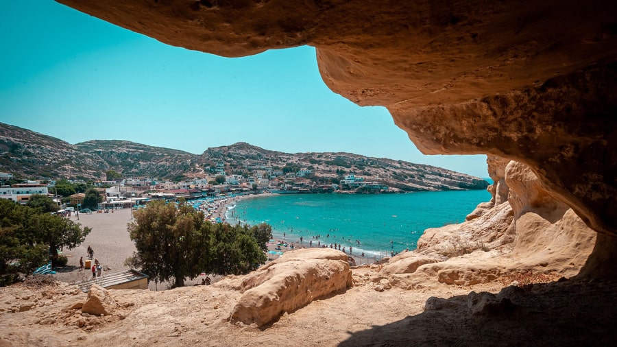
A Matala tour is a trip to the village of Matala on the south coast of Crete, below a cliff full of caves. The trip is one of the Greece Tours on Greece Ville, listed with the other Crete tours and day trips from Heraklion.
This post covers the village in numbers, the rock of the cave cliff, the Libyan Sea, the plants and animals of the coast, the Gortyn law code, the farms of the Messara plain and common questions.
What is a Matala tour?
A Matala tour is a trip to Matala, in the Faistos municipality, a local government area. A census is an official count of all the people who live in a place. The Faistos municipality had 23,921 residents when the 2021 census was taken.
On a Matala tour, the first number to know is the resident count. The 2011 census found 67 residents in Matala. The 2021 census found 84 residents in Matala, so the number went up.
Two older census counts give a longer view of the population of Matala. In the 1951 census, Matala had only 3 residents. Later, in the 1981 census, Matala counted 337 residents in total.
The area behind a Matala tour has local units of government. Pitsidia is the seat, or main town, of the local community that includes Matala. Pitsidia counted 692 residents in the 2021 census.
A municipal unit is a smaller part of a local government area. The Tympaki municipal unit, which includes Matala, had 9,957 residents in the 2021 census. The same unit covers 157.1 square kilometres.
- Moires: The Moires unit, part of the Faistos municipality, had 11,399 residents in the 2021 census.
- Kofinas: The Kofinas unit covers 144.8 square kilometres and had 4,076 residents in the 2021 census.
- Asterousia: The Asterousia unit had 4,943 residents in the 2021 census and covers 203.4 square kilometres.
Kapetaniana is a village on the slopes of the Asterousia Mountains. It stands at an altitude of 750 metres above sea level.


Which rock holds the caves on a Matala tour?
A Matala tour is a trip to a coast of old sea sediments. A university study dates these sediments to the Tortonian age. That age falls between 11 and 6.7 million years ago. Sandstone, limestone and coral rock appear along this coast.
On a Matala tour, large sloping layers appear in the Matala sandstone. These layers show sand piled up as underwater dunes. Swell, which means long sea waves, or currents shaped the dunes.
Rhodoliths are loose lumps of red algae that roll along the sea floor like tumbleweeds. At Matala, a massive rhodolith bed is about 5 m thick. Its lumps are up to 7 cm across.
On a Matala tour, the archaeological site west of Matala has a stack of rock layers. Rhodolith limestone lies at the bottom. Sandstone covers it, then a massive rhodolith bed, then coral rock.
Two fossil coral layers form cliffs around the Bay of Matala. Each layer is 1 to 5 m thick. They stand out because they are harder than the beds around them.
- Red names: Red-tinted sediments gave the coast names such as Red Beach and Sidheropetra, which means iron stone.
- Limestone: The layers reach 80 m in thickness along the west coast between Matala and Vathi.
- Sandstone: East of Matala, the sandstone is up to about 24 m thick, counting thin pebble beds.
South of Matala, the Asteroussia Mountains become a high flat area. It is 5 km wide and tilts west toward the Libyan Sea.
What does the Libyan Sea show off a Matala tour?
A Matala tour is a good time to learn about the Libyan Sea and Mediterranean water. A line marks where the Libyan Sea meets the Levantine Sea. The line runs from Ras al-Helal in Libya to the Greek island of Gavdos.
On a Matala tour, the size of the Mediterranean sea is worth knowing. The whole sea covers about 2,500,000 square kilometres. That area is around 0.7% of the surface of the world ocean.
The Mediterranean holds about 3,750,000 cubic kilometres of water. Water stays in the sea for about 80 to 100 years before renewal. Its water temperature runs from 12 °C to 28 °C.
During a Matala tour, the Levantine Sea lies just east of the Libyan Sea. Model averages put winter surface water there near 17 °C. They put August water there near 28 °C.
Atlantic water enters the Mediterranean at the Strait of Gibraltar at about 14 to 16 °C. The strait, the sea’s gateway to the Atlantic, is only 14.2 kilometres wide at its narrowest point.
- Surface salt: Surface water holds about 38 parts of salt in every 1,000 parts of water.
- Eastern summer: In the east in summer, surface salt approaches 40 parts in every 1,000 parts of water.
- Deep salt: Deep water holds about 38.4 parts of salt in every 1,000 parts of water.
Open-ocean water looks blue because it is very clear and holds only a small number of particles. Tens of metres of water absorb all light.
Which plants and animals live around a Matala tour?
A Matala tour can be paired with learning about the wildlife of Messara Bay on Crete. Loggerhead sea turtles lay their eggs in nests on the sandy beaches there. A protected area there also shelters a Cretan palm and local snails.
For a Matala tour, the loggerhead sea turtle is the key animal to know. It nests on 8 km of beaches in Messara Bay. A turtle group has monitored them since 1993.
The group ranks Messara Bay as the third largest loggerhead nesting area on Crete. The average is 115 nests each year. In summer 2023, the group counted over 230 loggerhead nests there.
During a Matala tour, the Natura site GR4310004 is another place to know. Called Western Asterousia, it is a protected nature area of 2,650.79 hectares. It includes two thirds of the coastline of Messara’s bay.
In 2018, 75% of beach businesses in Messara Bay made space on the sand for nesting turtles. That share was down from 100% in each of the two years before.
- Turtle site: Western Asterousia is one of the top three places in Greece where loggerheads lay eggs.
- Cretan palm: This palm, Phoenix theophrasti, grows in a small patch at Martsalos, inside the Western Asterousia site.
- Snails: The site shelters snails such as Albinaria terebra, which lives only in south Crete.
Tourism development, illegal building, illegal hunting and illegal fishing threaten the Western Asterousia site. Overgrazing, or too much feeding by animals, is another threat.
What did the Gortyn law code say near a Matala tour?
A Matala tour raises the question of what the Gortyn law code said. The code is an inscription, which means words carved into stone. Apart from the inscription of Diogenes of Oenoanda, it is the longest ancient Greek inscription that survives.
On a Matala tour, the first thing to know is how the code is written. It uses boustrophedon writing, where one line runs left to right and the next runs right to left.
The word boustrophedon comes from Greek and means “like the ox turns” while ploughing. The surviving text runs for about 10 metres along a round wall and stands 1.5 metres high.
During a Matala tour, the Gortyn law code is the topic. It covers disputed slave ownership, rape and adultery, divorce and inheritance. It also covers property sales, ransom, mixed marriages and adoption.
The code names four social classes: free people, serfs, slaves and foreigners. After a divorce, the wife kept the property she brought to the marriage. She also kept half of what she had woven.
- Children: A child born after divorce went to the father, or to the mother if he refused.
- Inheritance: When a father died, his property was split: each son got two parts, each daughter one.
- Adoption: An adoption had to be announced in the market-place while the citizens were gathered.
People have called the Gortyn laws the Queen of the Inscriptions. The Louvre in Paris holds a piece of the code’s 11th column.
What grows on the Messara plain near a Matala tour?
A Matala tour is close to the Messara plain, where olive groves cover 64.6% of the valley. Alluvial deposits, which are soil left by rivers, cover 23.3% of the Messara Valley. These hold the valley’s best farm soils, grown with olives, vegetables and citrus.
Near a Matala tour, the Messara Valley receives about 600 mm of rain in an average year. The agricultural town of Moires, in the Messara, averages 445 mm of rain in a year.
Of that rain, about 65% is lost to plants and evaporation, water drying into the air. Another 10% runs off to the sea. Only 25% of it refills the groundwater, the water stored underground.
Close to a Matala tour, the Messara has two main river basins. The Geropotamos drains the west, and the Anapodaris drains the east. The Geropotamos flows west and reaches the Libyan Sea near Tympaki.
The larger part of the valley’s old hill forests is now farmed. Farmers grow olives, vines, vegetables, fruit and cereals there. Crete has over 13,000 greenhouse units, nearly 50% of all greenhouses in Greece.
- Reservoirs: Nine main reservoirs in the valley store about 25 million m³ of water in total.
- Wells: Almost 80% of the deep wells in the Messara Basin are run by private operators.
- River flow: The Geropotamos carries about 14 million m³ a year and almost dries up in summer.
Messara farmers plough their olive groves once or twice in spring, mainly to save water in the soil.
What do visitors ask about a Matala tour?
A Matala tour raises questions about daylight, UV rays, spiny sea animals, beach law and tides. At Matala, July logs about 396 hours of sunshine and December only about 130. Britain’s health service says not to touch spines with bare hands.
How does daylight change through the year on a Matala tour?
On 21 June, the sun stands highest over Heraklion at 13:21 local time. Full darkness comes only from 22:25. On 21 December, the sun stands highest over Heraklion at 12:17, and full darkness comes from 18:41.
How strong is the UV index for a Matala tour?
The UV index rates the strength of the sun’s ultraviolet rays. Heraklion’s average is 3 in February, 5 in March and 6 over the year. Fitzpatrick type III skin, which includes light-skinned Mediterranean people, only sometimes burns.
Which spiny sea animals matter on a Matala tour?
About 80 of 600 sea urchin species contain poisons. As a rule, they cause people no significant harm. A greater weever has one venom spine on each gill cover. Its back fin has five to eight venom spines.
What does Greek law say about beach use on a Matala tour?
Greek law 2971/2001 says the foreshore and beach mainly serve free, open access. The foreshore is the strip of land beside the sea. Where umbrellas and sunbeds are rented, at least 50% of the foreshore must stay free.
What does the law say about sand and shells on a Matala tour?
Law 2971/2001 punishes taking soil, stones or sand from a beach without a permit. The penalty is at least one year in prison. EU law bans the deliberate capture or killing of the fan mussel, Pinna nobilis.
How big are the tides on a Matala tour?
In the greater part of the Mediterranean, the main tide is under 10 centimetres. The main tide peaks in the Gulf of Gabes at 53 centimetres. Narrow ocean entrances let in too little tidal energy, so tides stay small.