
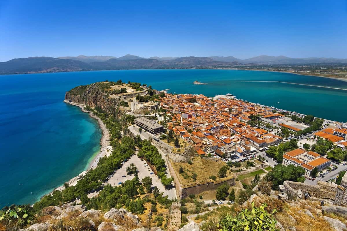
A Nafplio day trip is a visit to the seaside town of Nafplio in the Argolid, in the east of the Peloponnese. The town has Venetian castles, old squares and a long past as a port. It is one of the Greece Tours on Greece Ville, listed with the other day trips from Athens and Peloponnese tours.
This post covers what a Nafplio day trip is, how the town became the first capital and what the Argolic Gulf shows. It also covers the castle builders, the buildings and squares and the people who shaped the town. The Argolid plain, food, the coast, the road from Athens, the best time of year and common questions come last.
The sections include Nafplio day trips and related Peloponnese tours that can be booked online.
What is a Nafplio day trip?
A Nafplio day trip is a single-day visit to a coastal city in the Peloponnese, in Greece. The town ranks as the top Greek destination for weekend or one-day excursions. Visitors come mainly from Athens and other Greek cities.
A Nafplio day trip reaches a town on the Argolic Gulf, in the northeast Peloponnese. The bulk of the old town stands on a peninsula jutting into the gulf. This peninsula forms a naturally protected bay.
Marshes once almost cut the city off. A marsh is a wet, soggy lowland. Landfill projects, mainly since the 1970s, have nearly doubled the city’s land area. Such projects add earth to create new ground.
A Nafplio day trip visits one part of a larger municipality, a local council area. That municipality covers 390.241 square kilometres. It lies in the regional unit, or wider district, of Argolis. A regional unit groups a number of municipalities under one authority.
The city has named quarters, such as Gyalós, Kourti, Psaromachalas and Prónoia. The old town forms its own quarter on the peninsula.
A Nafplio day trip explores a town with a name drawn from myth. Legend links the name to Nauplius, a son of the sea god Poseidon and Amymone. His name means “seafarer” in Ancient Greek.
Strabo thought the name came from the town’s harbour instead. Pausanias wrote that the first Nauplians were Egyptians from the colony of Danaus at Argos. In his own time, the 2nd century, the place stood deserted.
- Tourism: Tourism grew into a major business after the Greek Civil War.
- Mass tourism: Nafplio was one of the first mainland areas to develop mass tourism.
- Year round: Its old buildings, mild climate and nearness to the capital draw visitors in every month.
A Nafplio day trip packs these layers into one compact town. The bay, the old quarters and the castles all sit on the peninsula and its slopes.


How did Nafplio become the first capital on a Nafplio day trip?
A Nafplio day trip reaches a town that Greek rebels took from Ottoman forces. Its strong forts then made it the seat of the provisional government. That was a temporary wartime government. Greece’s first governor and first king both landed there.
A Nafplio day trip recalls a long siege in the Greek War of Independence. Greek forces surrounded the town for more than a year, from the spring of 1821. The Ottoman troops gave up because of forced starvation. A siege is when an army surrounds a town and cuts off its supplies.
On 30 November 1822, Greek forces led by Staikos Staikopoulos captured the Palamidi fortress. That victory freed the town after the long siege.
A Nafplio day trip passes the Vouleftiko, or “Parliament House”, a former mosque. Full sessions of the first Greek parliament met there until the spring of 1826. A parliament is the assembly that makes a country’s laws.
During civil war fighting, the government twice took refuge in the Bourtzi sea castle. On 2 July 1827, a mortar bomb struck the parliament building. The blast killed Christos Gerothanasis, an elected deputy who was inside.
A Nafplio day trip also traces Count Ioannis Kapodistrias, Greece’s first head of state. His official title was Kyvernetes, meaning Governor. A head of state is the person at the top of a country.
Kapodistrias made Nafplio the official capital of Greece in 1829. After his death, a period of anarchy followed. It lasted until King Otto arrived and the new Kingdom of Greece was set up.
The governor oversaw the rebuilding of the ruined Grimani Barracks on Acronauplia. In 1830, the former Trianon Mosque became a mutual-teaching school for poor families. In such schools, older pupils taught younger ones.
- Royal arrival: King Otto reached Nafplio on 30 January 1833 with a fleet of 43 ships.
- Naval move: In September 1822, Andreas Miaoulis drew Greek ships into the gulf against an Ottoman fleet.
- Capital move: In 1834, Athens was declared the capital of the Greek state.
Nafplio remained a military centre after the move. The new capital was then a small town of roughly 4,000–5,000 people. Thousands had lined the Nafplio docks to watch the young king arrive.
What does the Argolic Gulf show on a Nafplio day trip?
A Nafplio day trip shows the Argolic Gulf, an arm of the Aegean Sea. The gulf lies off the east coast of the Peloponnese. It is about 50 kilometres long and 30 kilometres wide. Nafplio is its main port, at the northwestern end.
A Nafplio day trip looks over a gulf with a maximum depth of 800 metres. Its central part holds sediment layers 500 metres thick. Sediment is sand and mud that settles on the seabed.
Surrounding mountains shield the water from the strong summer Meltemi, a dry north wind of the Aegean. In the Pliocene and early Pleistocene, ancient geological ages, the gulf stretched north to the Gulf of Corinth.
A Nafplio day trip sees a gulf bordered by two regional units. Arcadia lies to the southwest. Argolis lies to the north and east. Shore towns run from Tyros in the southwest to Porto Cheli in the east.
The town of Nea Kios lies at the mouths of the Inachos and Erasinos rivers. Both rivers carry water down from the hills to the gulf.
A Nafplio day trip also reveals an old harbour role. Early Nauplia, the town’s ancient name, belonged to a sea league that met on Calaureia island. A sea league was an alliance of coastal towns that shared decisions. Later, Nauplia appeared in history only as the seaport of Argos.
The Argives conquered Nauplia around the time of the Second Messenian War. Sparta then gave its exiled citizens the town of Methone in Messenia.
Psili, Platia and Romvi are the largest islands in the gulf. Romvi lies near the eastern shore, opposite Tolo, and had no residents in 2011. Old fortifications, ruined houses and water reservoirs survive there.
- Sea league: Calaureia, where the old sea league met, is an island in the Saronic Gulf.
- Arcadian shore: Tyros and Paralio Astros sit on the Arcadian side of the gulf.
- Eastern end: Porto Cheli and Spetses close the line of gulf towns in the east.
A Nafplio day trip shows why the gulf shaped the town. Its sheltered bay made Nafplio a port long before the Greek state existed.
Who built the fortifications seen on a Nafplio day trip?
A Nafplio day trip passes walls raised by ancient Greeks, Franks, Venetians and Ottomans. Venetian engineers built the sea castle in the harbour and the hill fortress. Ottoman builders later finished its last bastions, the angled platforms that carry guns.
A Nafplio day trip begins below Akronafplia, the rocky peninsula where the town started. Builders first walled it in the late 4th century BC. In the early 13th century, the Franks split it with a cross wall.
Venice bought the castle in 1389 and adapted it for cannon. In 1470 builders pushed the walls east with Tori Castle. Engineer Antonio Gambello then added a cross wall inside the Frankish half.
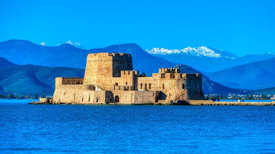
A Nafplio day trip also shows Bourtzi, the sea castle on a harbour islet. The same engineer began work there in June 1471. He went back to Venice a year later, and Brancaleone took over.
Between 1480 and 1515, every ship entering the harbour had to carry a load of stones. The stones formed an underwater ring of boulders that kept deep ships away. The central tower is six-sided and holds four vaulted rooms.
A Nafplio day trip then reaches Palamidi, on a hill 216 metres high. Work began in 1711 under Agostino Sagredo, a Venetian fleet commander. Antonio Giancix, also written Giaxich, drew the main plans. French engineer Pierre de la Salle built it by 1714.
Each bastion worked as its own small fort. Every one held barracks, water tanks, gunpowder stores and food depots. If an enemy took one bastion, the others kept up the fight.
- Saint Andrew bastion: The first bastion built once honoured Saint Gerard, patron saint of the commander’s family.
- Miltiades: Its walls reach 22 metres high, with a moat on the south and east.
- Land Gate: The same French engineer built this granite town entrance in 1708.
Venice first named the eight bastions after its provveditori, the governors it sent abroad. The Ottomans gave them Turkish names. Free Greeks chose ancient heroes such as Leonidas and Themistocles. One honours Robert, a French volunteer killed at the Athens Acropolis.
Which buildings and squares stand out on a Nafplio day trip?
A Nafplio day trip centres on Syntagma Square, whose name means constitution. Two former mosques and a Venetian naval store frame it. A Catholic church that began as a mosque stands nearby. Neoclassical houses, styled on ancient temples, line the streets.
A Nafplio day trip reads the square’s past in its names. The Venetians named it Piazza dei Armi, or Plaza of Weapons. Revolution-era locals called it the Square of the Plane Tree. A revolt in 1843 forced a constitution and fixed its name.
The Vouleftiko, meaning parliament house, began as the Agha Pasha Mosque. Antonios Rhigopoulos from Langadia in Arcadia designed it. A 2021 study dates its completion between 1818 and 1820. Its domed prayer hall sits upstairs.
A Nafplio day trip passes the first parliament hall of modern Greece. Lawmakers chose in June 1824 to restore the ruined mosque, with engineer Theodoros Vallianos. The hall opened on September 21, 1825.
Across the square, about 100 metres away, stands the Trianon. It is the oldest surviving Ottoman building in town. The Venetians made it a church of Saint Anthony of Padua.
A Nafplio day trip also reaches the Archaeological Museum, a three-storey Venetian building. A Latin inscription dates it to 1713. The fleet commander built it as a store for ships. Later it housed barracks.
The Catholic Church of the Transfiguration sits on the castle hill’s north slope. Its low dome and mihrab, a Muslim prayer niche, recall a mosque. In 1839 the crown gave it to Bavarian soldiers and Catholic settlers.
- Crypt: Below the Catholic church lay remains of Philhellenes, the foreign friends of Greece.
- Saint Spyridon church: The Nafplio Brotherhood of Orthodox Greeks rebuilt this church in 1702.
- Ottoman fountain: Dervishes, members of a Muslim order, built the fountain facing that church in 1734-1735.
The square still mixes these layers of history. A Venetian store, two Ottoman mosques and a parliament hall stand side by side. The National Bank building completes its edge. The square took this shape during the second Venetian period, from 1686 to 1715.
Which people shaped the town on a Nafplio day trip?
A Nafplio day trip meets the people behind early modern Greece. The first head of state landed here and died on a church step. A young Bavarian king arrived at its docks. Myth gives the town’s name to a son of the sea god.
A Nafplio day trip starts with myth. The fortress hill honours Palamedes, son of the mythical founder Nauplius. Palamedes was a hero of Homer’s tales.
Theodoros Kolokotronis, a hero of the revolution, took charge of the town after its capture in 1822. Legend says he rode his horse up the steep slopes of the hill fortress to celebrate.
A Nafplio day trip retraces the arrival of Ioannis Kapodistrias, Greece’s first head of state. He landed here on 7 January 1828, his first step on the Greek mainland. He asked Stamatis Voulgaris to plan Pronoia, a quarter for war refugees.
On 9 October 1831 he was killed outside the church of Saint Spyridon. His killers came from the Mavromichalis family of Mani. The first shot missed, and its bullet still sits in the church wall.
A Nafplio day trip passes the harbour where Otto landed. This Bavarian prince took the Greek throne at age 17. He came with 3,500 Bavarian troops aboard the British warship HMS Madagascar.
A regency, a council ruling for the young king, ran the new state. In 1834 it jailed Kolokotronis in the fortress on a treason charge. Judges Anastasios Polyzoidis and Georgios Tertsetis refused to sign his death order.
- Lazaros Sochos: This Tinos sculptor cast that general on horseback, modern Greece’s first such statue.
- Dimitrios Ypsilantis: This army officer of the revolution died of illness here on 16 August 1832.
- Peter von Hess: This painter recorded the landing in The Entry of King Otto into Nauplia.
Sculptor Christian Heinrich Siegel carved a dying lion into the rock in 1840-1841. King Ludwig of Bavaria, father of the young king, paid for it. It honours Bavarian soldiers who died of typhus.
What does the Argolid plain hold around a Nafplio day trip?
A Nafplio day trip crosses the Argolid plain, where the central farmland of Argolis lies. Argolis covers 2,154 square kilometres and had 93,216 residents in 2021. Rivers, large springs and orange groves fill the flat land. Old myths and early towns sit beside them.
Argos is the largest city in Argolis, with 21,891 residents. It served as the home port of Nafplio’s harbour trade in the past. A village stood there about 7,000 years ago. People have lived on the same spot ever since.
A Nafplio day trip also meets modern Greek history in Argos. In 1829 the town hosted the Fourth National Assembly of Greece. That meeting adopted the phoenix as the country’s first currency.
The plain of Argos covers about 250 square kilometres. Rivers run down to it from mountains in the west. The Inachos, also called Panitsa, is 42 kilometres long and can run dry in summer.
On a Nafplio day trip, the Kefalari spring marks where the plain begins. Water from underground limestone channels bursts out at the foot of the hills. It feeds the Erasinos river, which meets the gulf at Nea Kios.
South of Argos lay Lerna, an area of springs and a former lake. Myth places the lair of the Hydra, a multi-headed water snake, there. Heracles killed it as his second labour. His nephew Iolaus burned each neck stump with fire.
A Nafplio day trip can stop at the Lerna site near Myloi. Its House of the Tiles measured about 12 by 25 metres. The two-storey building dates from 2500–2300 BC. Baked clay roof tiles gave it its name.
- Nea Kios: Refugees from Cius in Bithynia founded this seaport of Argos, and settlement began in 1927.
- Irrigation: A long concrete channel carries spring water across the Plain of Argos.
- Groundwater: Citrus farming and tourism have overused the underground water layer, letting seawater seep in.
Lake Lerna spread about 4.7 kilometres across in the Early Bronze Age. Cleared forests sent silt into it, and it became a marsh. Its last remnants were drained in the 19th century. Only the springs remain today.
What food and produce does a Nafplio day trip meet?
A Nafplio day trip meets a farm region of citrus, olives, artichokes and wine. Around Argos, citrus fruits lead, followed by olives and apricots. Local cooks make handmade pasta and lamb dishes. Official protected names cover the area’s artichokes and olive oil.
Argos is known for its own melon variety, called Argitiko. Dairy products and fruit processing factories add to the farm economy.
A Nafplio day trip toward Drepano enters mandarin country. The village holds one of the largest mandarin groves in Greece. Dozens of mandarin varieties grow there, led by the Clementine. Mandarin farming is the main work of local people.
The artichoke of Iria carries a Protected Geographical Indication, an EU label tying a food to its place. It comes from a local variety called Prasini tou Argous or Argitiki. The first harvest arrives in mid-autumn.
A Nafplio day trip south reaches the artichoke plains. The Iria plain covers 1,000 hectares, with the smaller Kandia plain beside it. The area gets over 2,500 hours of sunshine each year.
Gogges are an egg-free pasta of Argolis and Laconia. Cooks make them from flour, water and salt alone. The dough is cut into pieces 3-4 cm long. During Carnival, they are served with oil and mizithra cheese.
A Nafplio day trip meets other local dishes too. Striftades are a handmade pasta. Giosa is a dish of lamb or goat meat. Bogana pairs lamb with potatoes, and portokalopita is a local sweet.
- Ligourio oil: A Greek decision of 15 November 1993 gave Ligouriou-Asklipiiou olive oil a protected origin name.
- Nemea wine: Only Agiorgitiko grapes are allowed in Nemea’s top appellation, an official wine zone.
- Grape name: Agiorgitiko means “St. George’s grape” and is nicknamed the “Blood of Hercules” in Nemea.
In its later ancient revival, Asine had small olive oil and wine presses. Liquid flowed down sloping floors into tanks set in the ground. Today oranges and olives are the main farm resources of Argolis.
What does the coast around a Nafplio day trip show?
A Nafplio day trip reaches the shores of the gulf around the town. Beaches, islets, forts and the ruins of an ancient city line the water. Villages such as Tolo, Kantia and Drepano sit along the coast east and south of the town.
A Nafplio day trip starts below Acronauplia, the oldest part of the city. It stood as a separate town until the 13th century. Part of it later served as a prison, and a hotel now stands there.
Arvanitia lies between the Palamidi rock and the southern foothills of Acronauplia. The municipality lists it as the closest beach to Nafplio. A coastal walk there is called the “Arvanitia Circuit”. It looks out over the Argolic Gulf.
On a Nafplio day trip, a dirt road runs from the Arvanitia car park to Karathona. Karathona is a very large beach with shallow water. A rocky islet of the same name, also called Pontikonisi, lies close to the shore.
Tolo has 1,358 residents. The Byzantines used its bay as a second port for Nafplio. In 1834 a royal decree founded a town there named Minoa. The name honoured Minos, the legendary king of Crete.
A Nafplio day trip to Tolo faces the islets of Romvi and Daskaleio. Romvi covers 1.6 square kilometres and became an archaeological site in 1962. Daskaleio has fortress ruins and a small chapel.
Ancient Asine stood on the Kastraki headland, which measures 330 by 150 metres. Homer listed it among cities that sent ships to Troy. Swedish archaeologists from 1922 found its acropolis, or upper citadel, ringed by a Cyclopean wall of huge stones.
- Kantia: Arcadians and Cretan refugees built this village, which has 291 residents.
- Iria: Its beach runs 3.5 kilometres, and the village lies 22 kilometres south of Nafplio.
- Asine port: Underwater research since 2020 has found remains of a large ancient port.
Drepano was called Haidari until 1930. Its peninsula runs 3 kilometres and ends at the ruins of a Venetian castle. The village sits at the eastern end of the coast around Nafplio.
How far is the road on a Nafplio day trip from Athens?
A Nafplio day trip from Athens covers about 140 kilometres of road, says the town’s municipality. Drivers head west on the Olympia Odos motorway toward Corinth. A second motorway then carries traffic south through the Peloponnese. Short local roads finish the route.
The first leg of a Nafplio day trip runs on the A8, the Olympia Odos. Crews built it between 1962 and 1973 as National Road 8a. Its stretch from Elefsina to Corinth has three lanes each way.
The Corinth Canal cuts through the Isthmus of Corinth, a strip of land 6.3 km wide. The canal runs 6,343 metres, with no locks to lift boats. It is 8 metres deep. A motorway is a fast road with separate lanes for each direction.
Drivers on a Nafplio day trip cross the canal on a motorway bridge about 45 metres high. A railway line and a road also cross it. Builders completed the canal on 25 July 1893, after eleven years of work.
About 8 km past the Isthmus, the route forks left onto the A7, the Moreas Motorway. The A7 runs 205 km in total, down to Kalamata. Its Corinth to Tripoli part was built from 1984 to 1990.
A Nafplio day trip leaves the A7 after the Spathovouni toll station. Exit signs point to Ancient Nemea, Nafplio and Mycenae. At Tiryns, drivers turn left onto the Argos to Nafplio road.
- Bus link: KTEL Argolida, the regional intercity bus company, has served the town since 1952.
- Athens terminal: Buses for Nafplio leave from the KTEL Kifisou station on Kifisou Avenue.
- Old railway: A branch line with rails one metre apart reached Nafplio from Corinth in 1886.
- Rail pause: Train service on the line was suspended in 2011, during the Greek financial crisis.
The route passes near Corinth, which lies about 78 km west of Athens. Modern Corinth was founded as New Corinth in 1858, after an earthquake.
When is the best time of year for a Nafplio day trip?
A Nafplio day trip works in every season of the year. April and October bring mild days with modest rain. July and August bring heat and little rain. November to January brings the heaviest rain of the year.
Climate figures for a Nafplio day trip come from Greece’s national weather service station at nearby Argos. Its averages cover 1980 to 2010. Argos has a hot-summer Mediterranean climate, shown as Csa on the Köppen climate map. It ranks among the hottest places in Greece in summer. Köppen is a system that sorts world climates into types.
July is the hottest month, with an average daytime high of 34.0°C. July nights cool to an average low of 16.7°C. The month gets 9.1 mm of rain, spread over 2.1 rain days. July humidity averages 52.5 percent. Humidity is the amount of water vapour in the air.
A Nafplio day trip in April meets an average daytime high of 21.3°C. April nights drop to an average low of 6.7°C. The month brings 33.7 mm of rain over 8.6 rain days. One month later, the average high reaches 26.5°C.
September stays warm, with an average high of 29.7°C. October’s average high falls to 24.7°C, with 44.3 mm of rain. November is the wettest month of the year at 82.5 mm. Humidity that month rises to 76.7 percent.
A Nafplio day trip in January meets an average daytime high of 14.6°C. February nights are the coldest, with an average low of 2.9°C. December has the highest count of rain days, at 12.2. Snow is rare, though a significant fall hit Argos in early January 2017.
- Rain range: Yearly rainfall at Argos varies between 300 and 800 mm, depending on the year.
- Driest month: June gets only 8.9 mm of rain, on 3.0 rain days.
- March: The month brings 52.2 mm of rain and an average high of 17.4°C.
- Damp winters: December humidity peaks at 77.3 percent.
Sunny days are plentiful at Argos all year, even in winter. Readings below zero degrees Celsius come chiefly at night in the cold months.
What do travelers want to know about a Nafplio day trip?
A Nafplio day trip raises practical questions before the drive. Travelers ask about the nearest large airport and the size of the town. They also ask about its old names, its twin towns, its university and its old houses.
Which large airport sits near the Athens start of a Nafplio day trip?
Athens International Airport is the largest international airport in Greece. It opened on 28 March 2001. It lies about 20 km east of central Athens, or 30 km by road. Exit 2 of the A8 joins the Attiki Odos, a toll motorway to the airport.
What is the population of the town at the end of a Nafplio day trip?
The 2021 census counted 14,532 people in the community of Nafplio. The wider municipal unit, which adds the communities of Aria, Lefkakia and Pyrgiotika, held 19,375 people. The full municipality, with 32,625 residents, formed in 2011 from four former municipalities. These were Asini, Midea, Nafplio and Nea Tiryntha.
What other names has the town of a Nafplio day trip carried?
Its oldest known mention is an Egyptian temple text from the 14th century BCE. In the Greek of ancient Athens and in Latin, the town was Nauplia. Venetian rule gave it the Italian name Napoli di Romania. Ottoman Turks called it Mora Yenişehir, after Morea, a medieval name for the Peloponnese.
Which twin towns share links with the town of a Nafplio day trip?
Nafplio is twinned, or formally paired, with towns abroad. Ottobrunn in Germany joined in 1978, and Burgas in Bulgaria in 1984. Poti in Georgia followed in 1990, and Cetinje in Montenegro in 1995. Ypsilanti in Michigan joined in 1997, and Royan in France in 2005.
Which university school stands in the town of a Nafplio day trip?
The University of the Peloponnese runs its School of Fine Arts in Nafplio. The school joined the university in 2003. In 2007, its Department of Theatre offered four majors, including acting, dance, and set and costume design. The university was founded in 2000, with headquarters in Tripoli.
Why did old houses survive in the town of a Nafplio day trip?
From the 1950s, a Greek building deal called antiparochí swapped plots for flats in new blocks. Nafplio escaped the wide loss of traditional buildings it caused. Archaeologist Evangelia Protonotariou Deilaki led the effort to save it. In 1962, the old town was declared an archaeological site and protected monument.