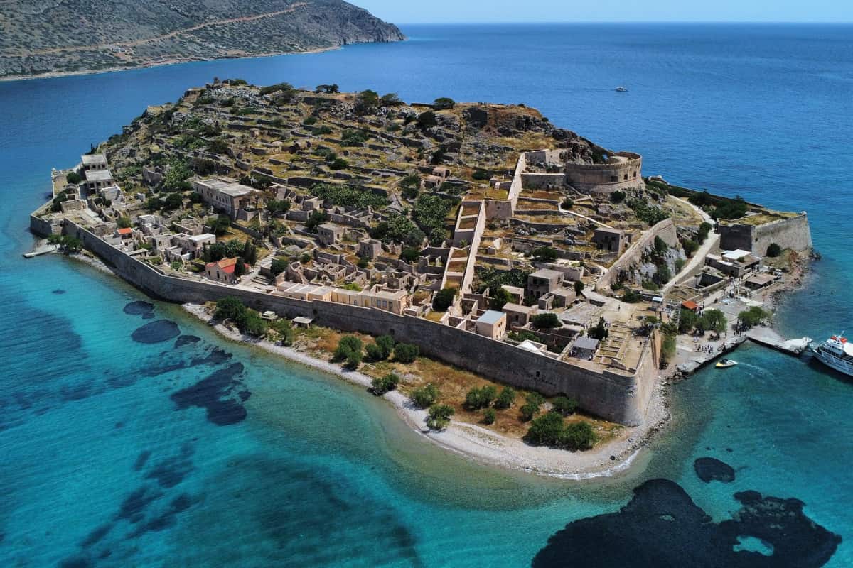
A Spinalonga tour is a boat trip to the island of Spinalonga, at the mouth of the bay of Elounda in eastern Crete. The island holds a Venetian fortress and the ruins of an old village. It is one of the island tours in Greece on Greece Ville.
This post covers what a Spinalonga tour is, the fortress and the boat route. It also covers the leper colony, the disease and the Ottoman village. Ancient places nearby, the best time of year and common questions come last.
The sections include Spinalonga tours and related boat trips that can be booked online.
What is a Spinalonga tour?
A Spinalonga tour is a trip to a small island. The island lies in the western part of the Gulf of Mirabello. It measures up to 440 m from north to south. Visitors explore its old walls, its history and its rocky shore.
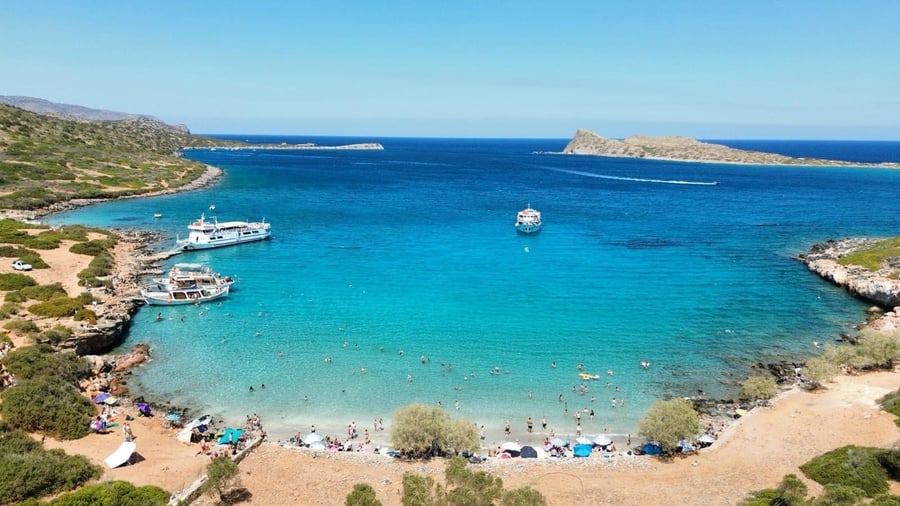
At its widest point, in the south, the island is 250 m across. Its highest point rises 53 m above the sea. Only 160 m of sea separate it from the Spinalonga peninsula. The island has no freshwater springs. Freshwater springs are places where drinking water flows up from the ground.
The Venetian map maker Vincenzo Coronelli wrote that the island was once joined to the peninsula. He said the Venetians cut part of it away in 1526. Venice already had an island called Spinalonga, known today as Giudecca.
Under Ottoman rule, Turks called the island Spirlonga. A local legend links that name to a love story between Spiros and Longa. A legend is an old story that people pass down. In 1954 the island officially took back its ancient name, Kalydon. Still, Spinalonga stays the more common name, even on a Spinalonga tour.
- Old wall: Recent research dates a wall the Venetians found to the 7th or 8th century AD.
- Old photo: Giuseppe Gerola, an Italian archaeologist, photographed part of it in 1901.
- Pottery: Finds show that people were there in the 11th and 12th centuries.
A Spinalonga tour also takes in the neighbouring peninsula, up to 5.2 km long and 2.2 km wide. It separates the Gulf of Elounda from the Gulf of Mirabello. It is a listed archaeological site. This means the law protects its old remains.


What is the Venetian fortress on a Spinalonga tour?
A Spinalonga tour centres on a large Venetian fortress. The Venetian Senate decided to fortify the island in 1571. The fortress has two zones of walls. One wall follows the coast, and a second one stands on the steep rocks of the ridge.
Latino Orsini, a Venetian engineer, served as military commander of Crete. He was the second designer of the fortress. He judged the first plan too weak. Enemies were able to attack it from the nearby peninsula. So in 1585-1586, builders walled the rocky ridge.
On a Spinalonga tour, the coastal ring of walls runs for about 1,200 m. The Tiepolo bastion on the south-west side is the largest. A bastion is a strong corner of the wall. The Michiel demi-lune, a half-moon bastion, guards the harbour entrance.
The Barbariga demi-lune on the south side has five arched cannon ports. Cannon ports are openings in a wall for firing cannons. Four of them face the Kolokytha hill. Zuanne Mocenigo, the Venetian governor-general of Crete, laid its foundation stone in 1581.
- Southern gate: This vaulted passage is 21 m long and rests on eight limestone arches.
- Busy entrance: Winds made the southern dock easier to reach, so this gate saw more use.
- Building stone: Builders used hard island limestone and a soft sandstone called ammouda.
In peacetime, two troops of 300 men guarded the fortress. In 1878, Cretan rebels still failed to take it.
How does the boat route work on a Spinalonga tour?
A Spinalonga tour by boat crosses the waters around the Spinalonga peninsula. The route passes coastal villages, old windmills and salt pans. Each place along the shore holds its own story from Venetian or much more recent times.
Plaka lies 16 km from Agios Nikolaos. The village is built just 5 m above sea level. It is listed as a traditional settlement. Schisma, the seaside centre of Elounda, lies 71 km from Heraklion.
On a Spinalonga tour, the isthmus of Poros comes into view. An isthmus is a thin strip of land between two seas. It links the peninsula to Elounda. Its windmills stand beside the Elounda canal, by the sea.
The Elounda salt pans lie at the inner end of the gulf. Salt pans are shallow pools where sea water dries and leaves salt behind. They sit on the road from Schisma to the peninsula. In 1653 the Venetians wrecked them so the Ottomans gained no profit. The pans worked until the 1970s.
- Poros windmills: Each one is round, up to 5 m across, with stone walls 80 cm thick.
- Sea battle: In 1204 the Venetians defeated the Genoese in the Gulf of Elounda.
- Venetian harbour: From the late 16th century, Spinalonga harbour ranked second in Crete after Souda.
During the wartime occupation of Greece, the peninsula area was the largest German naval base. A naval base is a place where warships stay and get supplies. A Spinalonga tour also links the island with Agios Nikolaos, built on and around five hills.
What was the leper colony on a Spinalonga tour?
A Spinalonga tour visits the old leper colony that opened on the island in 1904. The first patients were 148 men and 103 women. By 1933, 954 people lived there. The last group of about thirty patients left on June 19, 1957.
Leprosy was especially widespread in Crete during the 18th and 19th centuries. Under Ottoman rule, patients lived outside the towns. These areas were called meskenies, from the Turkish word miskin. The Cretan State later picked Spinalonga, partly because its empty Ottoman houses had room for the patients.
Once confined, patients lost their political rights and their property. The marriages of married patients were annulled, which means cancelled by law. A yellow flag flew from the highest point of the island. It warned travellers that leprosy was present.
A Spinalonga tour also tells how the patients built a community. Their Brotherhood was the first society of its kind in Greece. Its leader, Epaminondas Remoundakis, chose to move there, where his sister already lived. Its offices held a small library and a radio.
- Market: Patients bought goods outside the main gate with money that was sterilised first.
- Games: Residents played backgammon and checkers on the sunny, wind-protected east side.
- Buildings: Architect Orestis Maltos designed two plain dormitory blocks at the northwest edge in 1937-1939.
Patients began a hunger strike in 1953. The state was slow to replace the leper hospitals with one central hospital in Athens. One patient later wrote the final leaving date in pencil on the wooden hospital door.
What is leprosy and how is it treated, seen on a Spinalonga tour?
A Spinalonga tour explains leprosy, also called Hansen’s disease. It is a long-term infection by the bacterium Mycobacterium leprae. Modern multidrug therapy, a mix of three medicines, treats it. Treatment lasts 6 months for light cases and 12 months for heavy ones.
The name comes from the Greek word lepra, from lepis, meaning scale. The Norwegian doctor Gerhard Armauer Hansen found the bacterium in 1873. It was the first bacterium identified as a cause of disease in humans.
The bacterium grows best at 27 to 30 °C. So it attacks the cooler skin, the nose lining and the nerves. Damaged nerves stop feeling pain. Unnoticed wounds can then cost people parts of their fingers and toes.
On a Spinalonga tour, visitors learn how slowly medicine arrived. For centuries, oil from the chaulmoogra tree went on the skin. In 1915 Alice Ball made this oil dissolve in water, which helped far more. In 1927 the Nobel Prize-winning doctor Charles Nicolle visited the island.
- Hygranol: After his visit, Nicolle sent 10,000 doses of the anti-leprosy drug Hygranol.
- Promin: In 1941, 22 patients in Carville, Louisiana, tested promin with results called miraculous.
- Delay: The new drugs first reached Spinalonga only in 1948.
- Spread: Leprosy passes in droplets during close, frequent contact, not through handshakes, hugs or shared meals.
About 95% of exposed people never develop leprosy. Around 200,000 new cases are still reported every year in more than 120 countries. Worldwide, the disease stopped being a public health problem in 2000.
What does the Ottoman village show on a Spinalonga tour?
A Spinalonga tour walks through the Ottoman village on the south and west sides. In 1718, Muslim soldiers called Janissaries settled there with their families. The village once had about 200 houses. Dozens still stand, mainly near the main road.
The only customs office of the Merabello province opened here in 1718. A customs office collects taxes on traded goods. Ships loaded salt, leather, honey, wax, grindstones, silk and carobs.
By the late 1870s and 1880s, 1,112 people lived here in 227 families. In 1886 the island became a municipality, a town with its own council. Literacy, especially among women, was higher than in Chania, Rethymno or Heraklion.
A Spinalonga tour also shows how the houses were built. A typical house had two floors and a walled stone courtyard. Builders used tsatmades, a wooden frame with cross beams filled with light materials.
- Mosque: The mosque stood in the west, where the Catholic church of Agia Varvara had been.
- Hospital: The leper colony later put its hospital inside the empty mosque.
- Shops: Restored Ottoman shops on the main road now hold history exhibitions.
- Graves: Each Muslim grave had two tombstones, one at the head and one at the feet.
Records from 1879 to 1904 list 103 merchants, 19 grocers and 15 coffee sellers. The last Ottoman troops left Crete on 6 November 1898. House 104 once had a sachnisi, a wooden enclosed balcony.
What ancient places lie near a Spinalonga tour?
A Spinalonga tour passes close to old ruins along the coast and in the hills. Ancient Olous lay near Elounda. Lato sits on a hill above Mirabello Bay. The Church of Panagia Kera stands near the village of Kritsa.
Ancient Olous, also called Olountas, had more than 30,000 people. It ranks among the hundred leading cities of ancient Crete. The city made and traded purple dye. A stone from Olous, now in the Louvre in Paris, mentions a temple of Asklepios.
French navy troops found the first Olous remains on the Spinalonga peninsula in 1897–1898. A nearby 5th-century basilica shows dolphins in its floor mosaic. A basilica is a long early church hall. A floor mosaic is a picture made of small coloured stones.
Lato sits on a saddle between two hills. A saddle is a low dip of land between two higher points. A street of almost eighty steps climbed from its main gate to its agora, the market square. Nearchos, the admiral of Alexander the Great, was born there.
- Coins: The historian Nikos Svoronos recorded 11 different coin types made by Olous.
- Offerings: Pots left in rock cracks on the peninsula date from the mid-7th to the 4th century BC.
- Lost icon: In 1498 a trader stole the Kera icon, and it ended up in Rome.
These places add depth to a Spinalonga tour day. The large temple of Lato measures 10 by 16 metres. In the Middle Ages, Kritsa was thought to be the largest village in Crete.
When is the best time of year for a Spinalonga tour?
A Spinalonga tour works well in late spring and early autumn. October brings warm days near 23.5 °C at Sitia. Summer stays dry but hot and windy on the water. Winter brings the heaviest rain and the coolest nights.
The weather station at Sitia stands 114 m above sea level. Average highs there peak at 28.4 °C in July and August. In Agios Nikolaos, July nights average a low of 25.1 °C.
June brings only 2.2 mm of rain at Sitia, and August only 0.8 mm. A summer Spinalonga tour boat day is almost always dry. July is the windiest month, with a mean wind of 11.7 knots. A knot is a unit of wind speed used at sea. The crossing can then feel choppy.
Winter is wetter and cooler. January is the wettest month at Sitia, with 92.6 mm over 13.1 days. February brings the coldest nights, with an average low of 9.5 °C.
- June: Sitia has its driest air, at 60.4% average humidity.
- October: Sitia keeps lows of 17.3 °C for mild evenings.
- November: Sitia averages a high of 20.1 °C and 59.5 mm of rain.
Shoulder months suit a Spinalonga tour best for comfort. Shoulder months are the months between the hot summer and the wet winter. Sitia gets 468.9 mm of rain over 70.4 rainy days each year. The cold months bring the bulk of that rain.
What do travelers want to know about a Spinalonga tour?
A Spinalonga tour raises common questions about the island. People ask about its name and its fort. They also ask about its siege and its leper colony. Its last years and its protected status come up as well.
What does the name on a Spinalonga tour mean?
The name comes from Venice. An island in Venice was once called Spinalunga, meaning “Long Thorn”. The Venetians used Spinalonga for the harbour of Elounda and the rocky islet at its entrance. Historian John Julius Norwich linked the later change of the Venice name to Jewish merchants.
What happened to people on the island before the Spinalonga tour era?
In June 1715, 6,000 Ottoman soldiers attacked the island. It was held by 160 Venetian soldiers and Cretan rebels. It surrendered after three months. Of the captives, 466 were sold at market. Another 139 went to Constantinople as rowers, and 19 died on the way.
Why did Venice build the fort seen on a Spinalonga tour?
Threats from the Ottoman Empire were growing. The fort helped control trade routes to the Levant, the lands of the eastern Mediterranean. Genese Bressani helped design it. Two half-moon outworks guard key points.
What was the leper colony shown on a Spinalonga tour?
A leper colony was an isolated place where people with leprosy were kept apart and treated. Medieval Latin called it a leprosarium. The English term spread in the 1880s. A leprosy conference in Berlin in 1897 renewed support for isolating patients across Europe’s colonial empires.
When did the last patient leave before the Spinalonga tour days?
The island began to empty step by step in 1956. Werner Herzog’s 1968 short film Last Words tells of the last man to leave. He refused to go and was removed by force. Ethnographer Maurice Born visited in 1967 and found it abandoned for ten years.
Why is the site on a Spinalonga tour protected?
Greece put the island on the UNESCO tentative list under four cultural criteria. The file calls it a monument to human pain because of its leper hospital. It compares the fort with Suomenlinna off Helsinki. It compares the colony with Robben Island in South Africa.