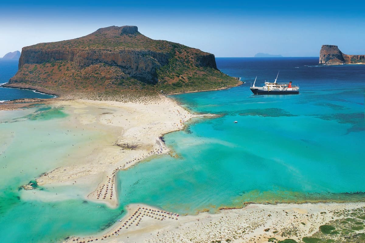
A Balos lagoon cruise is a boat trip to Balos Bay and the island of Gramvousa at the north-west tip of Crete. The bay has shallow turquoise water and pale sand. It is one of the boat cruises in Greece on Greece Ville.
This post covers what a Balos lagoon cruise is, where it starts and the Gramvousa peninsula. It also covers Imeri Gramvousa, the pink sand and the history. Wildlife, the sea and wind, sights on the coast, the best season, the protection of the area and common questions come last.
The sections include Balos lagoon cruises and related boat trips that can be booked online.
What is a Balos lagoon cruise?
A Balos lagoon cruise is a sea trip to Balos, a small lagoon in western Crete. The lagoon lies on the west side of the northern tip of the Gramvousa peninsula. It ranks with Elafonisi island and the Samaria Gorge among the main sights of western Crete.
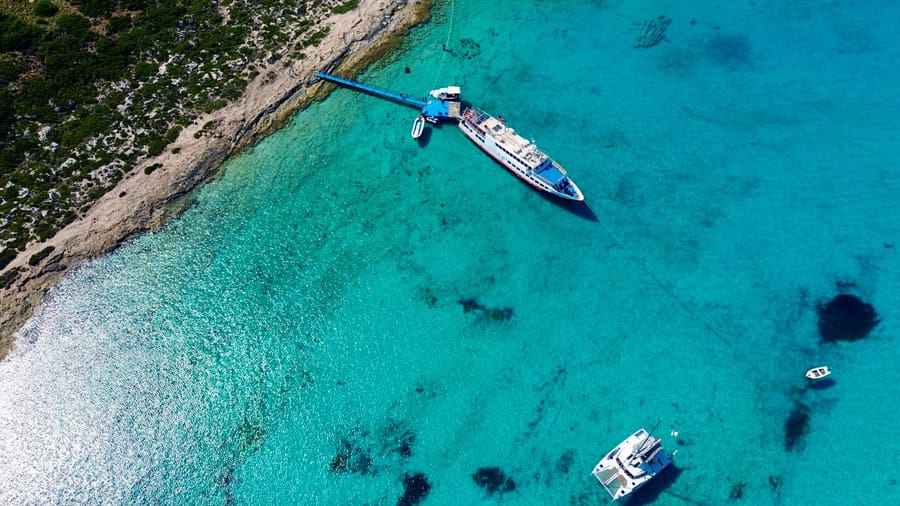
The lagoon lies about five km south-west of Cape Vouxa. At Balos, the Gramvousa peninsula is only about one km wide. The bay of Balos lies on the west side of the peninsula. The lagoon itself lies east of that bay.
A lagoon is a stretch of shallow sea water. A strip of land or rock partly cuts it off from the open sea.
The lagoon sits between the Gramvousa peninsula and the rocky Tigani peninsula. The Gramvousa side holds a mountain mass called Geroskinos. On the east, steep slopes and cliffs close the lagoon in. To the north, it opens into the bay of Gramvousa.
The Tigani peninsula is about one km long and 700 m wide. Cape Tigani rises to 117 m. It lies about one and a half km south of the island of Imeri Gramvousa. A flat strip of land about 50 m wide joins Tigani to the mainland.
This land bridge is natural cement, which is sand hardened into rock layers. Water holes have formed in it. East of the bridge, the lagoon measures about 400 m from east to west. It reaches about 600 m south from the open sea.
The water at Balos forms a natural harbour. The islands of Imeri Gramvousa and Pontikonisi shelter it from the open sea. This calm water sets the scene for the whole trip. A harbour is a place where boats find safe, quiet water.
- Depth: Over large parts of the lagoon, the water is less than 50 cm deep.
- Plants: No plants grow in the shallow lagoon water.
- Landscape: The Greek nature database Filotis describes the Balos landscape as almost untouched.
- Lagoons: The area is known for the lagoons formed between the mainland and the small Tigani peninsula.
Shallow water, a rocky cape and steep cliffs shape the whole scene at Balos. Each part of the landscape links to the next. Together they explain why a Balos lagoon cruise draws visitors to the far west of Crete.


Where does a Balos lagoon cruise start and end?
A Balos lagoon cruise links the Gulf of Kissamos with the lagoon by sea. The ferry port of Kissamos lies at Cape Kavonisi. It sits about three km north-west of the town, on the way to Kaliviani. Balos lies 17 km from Kastelli Kissamou.
Kissamos sits on the Gulf of Kissamos, between Cape Gramvousa and Cape Spatha. The town stands just 10 m above sea level. Until 1969, the town carried the name Kastelli. A gulf is a large bay where the sea reaches deep into the land.
Cape Spatha is the northernmost point of Crete. It lies at the far end of the Rodopou peninsula. That peninsula is 19 km long. The island of Imeri Gramvousa lies about 15 km north-west of Kissamos town.
Since January 2022, a shipwreck has sat in plain view in the northern bay of Kissamos. It is the cargo ship Manassa Rose M. A storm drove the ship onto a sandbank a short way off the coast. There it broke in two.
The village of Kaliviani lies 6 km west of Kastelli and 49 km from Chania. It stands 50 m above sea level, at the western end of the gulf. Kaliviani had 149 residents in 2021.
The paved road ends just past Kaliviani. From there, a dirt road runs north along the east side of the Gramvousa peninsula. It is nine and a half km long and ends near the lagoon.
- Chapel: Halfway along the track, the small chapel of Agia Irini stands above the Gulf of Kissamos.
- Parking: The track ends at a parking area about 100 m above sea level.
- Community: Kaliviani belongs to the community of Gramvousa, along with the islets of Agria and Imeri Gramvousa.
- Inland village: The village of Gramvousa, called Lardas until 1940, sits about 8 km west-south-west of Kissamos.
Near Trachilos, a village west of Kissamos, a rock slab holds possible footprints. Experts date them to about 5.7 million years ago. This old find adds depth to the coast around a Balos lagoon cruise.
What is the Gramvousa peninsula on a Balos lagoon cruise?
A Balos lagoon cruise passes the Gramvousa peninsula, a long arm of land in north-west Crete. It runs about 12 km north from Kaliviani to Cape Vouxa. Cape Vouxa is the north-westernmost point of Crete. The peninsula has no inhabitants today.
Kaliviani is the last village before the peninsula. In the south, the peninsula is about four km wide. Almost along its whole length, it is made of rocky limestone massifs with steep slopes. These slopes form rugged coasts that cannot be reached from the sea.
Geologically, the peninsula is carbonate rock. It is made of limestones of the Gavrovo-Tripolis series, a group of rock layers. At its tip, the Vouxa channel separates it from Agria Gramvousa. This channel is about 680 m wide and less than 20 m deep.
Limestone is a pale rock built from old shells and sea mud. Rain slowly wears it into sharp shapes and cliffs.
Hiking paths from Kaliviani cross the peninsula. One path goes through Gramvousa. The other path goes over Geroskinos.
The main plant cover is phrygana, a low and shrubby ground cover. Thorny burnet, Sarcopoterium spinosum, is one of the main shrubs. It is a spiny bush that flowers from February to April. In the summer heat, it looks dead.
Conehead thyme, pink rock-rose, spiny broom and false dittany are also main shrubs here. Spiny broom, Calicotome villosa, is a very spiny shrub 1–2 m tall. It has bright yellow flowers. The pink rock-rose, Cistus creticus, has pink flowers 4.5–5 cm across.
- Conehead thyme: It bears pink flowers in cone-shaped clusters in mid to late summer.
- False dittany: This low evergreen shrub forms silver-green mounds up to 50 cm tall.
- Mastic and carob: Both grow on the peninsula only as dwarf, creeping forms.
Bare rock, steep cliffs and low spiny shrubs give the peninsula a wild look. Each season changes its colours. This wild shore frames the whole route of a Balos lagoon cruise.
What is Imeri Gramvousa on a Balos lagoon cruise?
A Balos lagoon cruise passes Imeri Gramvousa, a small rocky island with an old Venetian fort. The island is more than 1200 m long and 1100 m wide. Steep cliffs ring every side except the south coast. Two small bays there make landing easier.
A Balos lagoon cruise lands on the south side. The boat jetty sits on the west side of the western bay. It lies right below the fort. The highest point, 124 m above the sea, lies in the south-west.
The Venetians used the fort to watch the Strait of Kythira. This is the sea between western Crete and the Peloponnese. Latino Orsini drew the plans and ran the building work. In 1588 lightning hit the powder store, and the fort blew up. It was rebuilt in 1630.
On a Balos lagoon cruise, visitors climb a steep path to the gatehouse. This best-kept part of the fort sits mid-way along the north-east side. Broken pieces of a stone Venetian lion of Saint Mark lie on the path. A stone coat of arms lies there too.
The lion of Saint Mark was the symbol of Venice.
The fort has the shape of a triangle. The south wall, about 175 m long, still stands well. So does the north-east wall, about 325 m long. The west side, about 285 m long, has no wall at all. It sits above a sheer drop to the sea.
Inside, two large vaulted cisterns survive. These stone tanks once collected rainwater from the stone paving. The old fort chapel still has its roof, a curved barrel vault. Half of its apse, the round end wall, has fallen in.
- Powder magazine: The old gunpowder store still stands, and the Ottomans turned it into a mosque.
- Plants: Scientists have recorded 173 kinds of ferns and seed plants on Imeri Gramvousa.
- Trees: Apart from a small group of tamarisks near the landing, the island has no trees.
- Shipwreck: The cement ship Dimitrios P, from Chalkida, ran aground on the south coast in January 1968.
A Balos lagoon cruise also passes Agria Gramvousa, the wilder island to the north. Goats grazed there, at least in earlier years. A French lighthouse company built a lighthouse on its northern part in 1874.
Why is the sand pink on a Balos lagoon cruise?
A Balos lagoon cruise lands on white sand that turns pink in places. Crushed shells and corals give it this colour. Tiny sea creatures grow in the lagoon water. When they die, their pink shells can wash up on the shore.
One key creature is Miniacina miniacea. It is a single-celled foraminifer, a tiny sea creature with a shell. It builds a pink, chalky shell with lots of small chambers. It lives on the leaves and rhizomes, or creeping stems, of Posidonia oceanica seagrass.
When these creatures die, their shells sink to the seabed. Currents can then carry them to the shore. The same shells help colour Elafonisi, another beach on Crete. They also tint the Spiaggia Rosa on the Italian island of Budelli.
The Pink Beach on Budelli also gets colour from tiny bits of coral. Shells of Myriapora truncata add to it too. This false coral is a bryozoan. It forms bright red chalky colonies from the surface down to 60 m.
A bryozoan is a tiny water animal. It lives in a group, called a colony, with thousands of others. The group looks like coral, so people call it false coral.
On a Balos lagoon cruise, the pink colour has more than one source. Coralline algae are red seaweeds with hard chalky deposits in their cell walls. They are mainly pink or red. Red coral, Corallium rubrum, gets its colour from pigments called carotenoids.
- Swash: After a wave breaks, a layer of water called swash runs up the beach and moves sand.
- Berm: Sediment builds up at the berm, the flat part of the beach where the swash ends.
- Summer seas: In calm summer seas, gentle waves carry sediment up the beach toward the berm.
A Balos lagoon cruise crosses a sea where tides have a fairly small range. The range is the gap between high and low water. A small range means the shoreline moves very little each day.
What history does a Balos lagoon cruise pass?
A Balos lagoon cruise passes waters full of war, piracy and myth. Venice held the area for centuries. Cretan rebels later used Gramvousa as a base. Ottoman, Russian and German forces also left their mark on the coast.
Strabo wrote that the people of Polyrrhenia once lived in villages. Achaeans and Lacedaemonians gathered them into one strong city. Later, a Roman aqueduct from the time of emperor Hadrian improved its water supply. An aqueduct is a channel that carries water from far away.
In 69–67 BC the Romans destroyed Phalasarna. Cisamus, under today’s Kissamos, then became the main port of Polyrrhenia. It had a theatre and an amphitheatre. Their remains were still visible in the 16th century.
On a Balos lagoon cruise, a myth joins the history. The explorer Tim Severin argued that Gramvousa was Aiolia, the island of Aeolus. In the myth, Odysseus spent a month there. He received a bag of storm winds.
Venice counted Grabusa among its overseas lands from about 1210. By spring 1648, the Ottomans held nearly all of Crete. Gramvousa, Heraklion, Spinalonga and Souda stayed Venetian. The siege of Heraklion, then called Candia, lasted 21 years.
In 1825 Cretan rebels took the fort. Up to 3000 people lived on Imeri Gramvousa at times. From there, the rebels attacked ships in the strait toward Antikythera. Part of the pirates’ loot is said to lie hidden in caves around the bay of Balos.
- Tigani: In 1825 Ottomans found and killed women and children hiding in a cave shaft on Tigani.
- Dalianis: Hatzimichalis Dalianis moved his 700 men from Gramvousa to Sfakia and died at Frangokastello with 385.
- 1941: German engineers landed two Panzer II light tanks in the Gulf of Kissamos on 28/05/1941.
A treaty of 1573 left Crete with Venice. In that treaty, Venice gave Cyprus to the Ottomans but kept Tinos, Corfu and Crete. In 1692 a Venetian fleet under Domenico Mocenigo attacked Crete and besieged Candia. It used the Gramvousa fort as a base.
A Russian garrison later held the fort and handed it back to the Ottomans in 1831. A garrison is a group of soldiers who guard a place. Every year on 29 June, locals sail from Kissamos to the island’s small church. They honour the apostles Peter and Paul.
What wildlife lives along a Balos lagoon cruise route?
A Balos lagoon cruise route passes a protected wild coast on the Gramvousa peninsula. Thorny scrub covers the land, and rare plants grow there. Vultures, falcons and seabirds fly over the cliffs. Monk seals have been recorded off the northern part of the peninsula.
Low scrub covers much of the Gramvousa peninsula. Thorny burnet, a spiny bush, grows beside Coridothymus capitatus thyme and Callicotome villosa. Cistus creticus and Ballota pseudodictamnus join them.
At Balos, small coastal sand dunes carry heather and mastic bushes. The protected site lists Cretan ebony among its plants. It also lists rock lettuce, a plant found only on Crete. Its Greek name recalls its old use in salads.
The sea daffodil was once common on the sandy shores here. Now it is slowly disappearing, as tourism building destroys its home. Almost every listed snail and slug lives only here or in western Crete.
Griffon vultures and bearded vultures live and nest close to or inside the site. The bearded vulture eats a diet that is 70–90% bone. The Gramvousa bird area matters for cliff birds of prey and seabirds. Eleonora’s falcon is its main species of concern.
A species of concern is an animal that needs extra care to survive. Birds of prey are hunting birds with strong claws and hooked beaks.
Eleonora’s falcon is 36–42 cm long, with a wingspan of 87–104 cm. These falcons lay up to four eggs. A Balos lagoon cruise passes cliffs of this kind.
- Seabirds: The shag and Scopoli’s shearwater appear on the Gramvousa bird list.
- Shearwater travel: Scopoli’s shearwaters leave for the Atlantic in late October and return in late February.
- Fast fliers: The peregrine falcon and the alpine swift also use the bird area.
- Reptiles: The European ratsnake, Balkan green lizard and Mediterranean house gecko live on the site.
Wild donkeys, once farm animals left behind, roam the whole peninsula. Crete holds about 25% of Greece’s loggerhead turtle nests. The Gulf of Chania is one of its three nesting sites.
What sea and wind conditions meet a Balos lagoon cruise?
A Balos lagoon cruise sails where the Aegean Sea meets open Mediterranean water. Strong north winds leave the Aegean near western Crete. Average waves there rank among the highest in Greek seas. Steep cliffs and a rocky peninsula close the lagoon itself.
The official southern edge of the Aegean runs through Crete to Agria Gramvousa, its north-west tip. The line then crosses to Cape Apolytares on Antikythera. A Balos lagoon cruise sails along this sea border.
Mediterranean water flows into the Sea of Crete through the Kythira–Antikythera Strait. The Kythira Strait ranks among the riskiest waters for ships in the Mediterranean. Its tsunami warning system uses earthquake recordings and tide gauge readings. A tide gauge is a tool that measures sea level.
Ships from Athens, Istanbul and the Black Sea cross this strait westward. They meet strong winds there. A shipping lane also runs along the west coast of Crete. Tankers leave oil waste, so tar lies along the site’s west coast.
A long-term wave model studied Greek seas. It found the highest average waves east and west of Crete. There, the north wind leaves the Aegean. A Balos lagoon cruise heads into this western exit zone.
A wave model is a computer program that works out wave sizes.
The biggest extreme waves form outside the Aegean, mainly south of Crete and in the southern Ionian Sea. Inside the Aegean, wind crosses only short stretches of open water. So extreme waves stay milder there. Storms, however, last longer in the Aegean.
- Summer peaks: In summer, the highest extreme waves form near the Aegean exits towards the Levantine basin.
- Long trend: Over the decades studied, waves in Greek seas became smaller, though not steadily.
- Water warmth: A satellite image measured sea temperatures on 30 August 2002. They ranged from under 16 °C to 23.5 °C.
- Warming sea: Buoys recorded a rise in central Cretan Sea temperature and saltiness from mid-2008.
Steep limestone slopes make much of the peninsula’s coast impossible to reach from the sea. At the lagoon, cliffs close the east side. A rocky peninsula joined by a narrow strip of land closes the west side.
What can visitors see near a Balos lagoon cruise on the Kissamos coast?
A Balos lagoon cruise runs off the Kissamos coast, an area rich in history. Ancient Falasarna has a lifted harbour and old towers. Polyrrhenia keeps strong walls inland. Gorges, caves and mountain villages lie a short way south.
Royal Navy captain T. A. B. Spratt found the old Falasarna harbour in 1859. It lay 100 yards from the sea. He worked out that the coast had risen at least twenty-four feet. Modern digs began in 1986 under archaeologist Elpida Hadjidaki.
Geologists think the undersea earthquake of AD 365 lifted Crete by about 9 m. Carbon dating shows coastal corals rose 10 m in one single push. The coast near a Balos lagoon cruise shows this lift.
Carbon dating is a lab method that tells the age of once-living things. The raised corals show where the old shoreline was.
A round sandstone tower at the harbour still stands 4.5 m high. A 50 m wall joins it to a rectangular tower. Six bollards, stone posts for tying ships, still carry rope marks.
A war between Falasarna and Polyrrhenia ended around 290 BC. The peace treaty, cut in stone, sits in the Kissamos museum. A Second World War landing craft sank here in 1941. It lies where the old harbour channel meets the sea.
The ruins of Polyrrhenia lie about 7 km inland from Kissamos. Its ancient walls stand 10 to 18 feet high. Strabo, an ancient writer, placed it 30 stadia from the sea. A stadion was an old Greek unit for measuring distance.
- Museum: The Kissamos collection began in 1936, and the museum opened in September 2006.
- Roman floor: The upper floor covers Roman Kisamos, with a digital display on the AD 365 earthquake.
- Topolia gorge: South of Topolia, the gorge runs 1.5 km between rock walls up to 300 m high.
- Agia Sofia cave: This cave in the gorge has a 20 m hall of stalagmites and stalactites.
The mountain village of Sirikari spreads over 12 small neighbourhoods. Its church of the Holy Apostles dates from 1427. Kissamos town had 4,321 residents in the 2021 census.
When is the best time of year for a Balos lagoon cruise?
A Balos lagoon cruise runs in the tourist season. The tourist season runs from the end of April to the end of October. July and August are hot and dry. June and September bring warm days with less heat.
The National Observatory of Athens runs a weather station at Falasarna. This town sits on the west coast of Crete, 10 m above sea level. In July, the average daily high is 31.7 °C. In August, it is 31.6 °C. Rain averages just 1.6 mm in July and 4.7 mm in August.
Summer nights stay warm at Falasarna. Average lows reach 24.5 °C in July and 25 °C in August. The hottest July reading at the station is 41.4 °C. Midday on deck feels very hot in these two months.
In September, Falasarna averages a daily high of 28.9 °C and 22.3 mm of rain. Souda, the airport station near Chania, counts only 2.6 rain days that month. For a Balos lagoon cruise, September brings mild, bright days.
In October, the Falasarna high is still 24.9 °C. But rain rises to 60.9 mm. Humidity at Souda climbs to 65.6% that month. Even so, Souda still gets 208.7 hours of sunshine in October.
Strong heat can come before summer starts. Falasarna has recorded 39.8 °C in late spring. On the night of 11 January 2021, foehn winds pushed it to 28.3 °C. Foehn winds are warm, dry winds that blow down a mountain slope. That was the warmest January night ever recorded in Greece.
- Wind: Around Kissamos, the main winds blow from the north, north-west and south-west.
- Sunshine: Souda logs 355.4 hours of sunshine in June and 355.7 hours in August.
- Night air: Average night lows at Souda are 19.2 °C in June and 21.3 °C in August.
The Greek register of protected landscapes calls the Balos climate one of high sunshine. Relative humidity at Souda averages 52.4% in June and August. A Balos lagoon cruise in early or late season avoids the hottest days.
What protects the area seen on a Balos lagoon cruise?
A Balos lagoon cruise passes through a protected Natura 2000 habitat. This is a European network of nature sites. Balos falls under two site codes, GR4340001 and GR4340017. Greek law also lists it as a Landscape of Outstanding Natural Beauty.
Site GR4340001 takes in the Gramvousa peninsula and the islets of Imeri and Agria Gramvousa. It also covers Tigani, Falasarna and the islet of Pontikonisi. The site spans 5781.32 hectares. Of that area, 3384.49 hectares is land.
Site GR4340017 covers 2839.56 hectares. It is listed for raptors, or hunting birds, of the sea cliffs and for seabirds. Eleonora’s falcon is its species of concern. Others on the list include the peregrine falcon, the European shag and the shearwater Calonectris diomedea.
Presidential Decree 67/81 is a Greek law that protects rare plants here. Limonium frederici grows on the Gramvousa islets. Trigonella rechingeri grows on the peninsula. All reptiles of the site are threatened species. This decree and the Bern Convention, a European nature treaty, protect them.
The landscape register lists Balos under code AT6020012, covering 2898.84 hectares. It gives Balos a protection priority of very urgent. Threats include litter, grazing, hunting, motorboats and tourism. The register warns that more tourism, new roads or harbour works threaten lasting harm to this small-scale landscape.
- Road: The site record names the road across the peninsula as the main human disturbance.
- Oil: Tankers west of Crete leave oil waste and tar traces along the west coast.
- Ticket: A guard post on the dirt road collects a ticket for road upkeep and protection.
- Local rules: Each Greek Natura 2000 site follows rules from its own study.
EU law adds firm rules for visitors on a Balos lagoon cruise. Article 13 of the Habitats Directive bans picking, cutting or uprooting strictly protected wild plants. Article 12 bans deliberate disturbance of strictly protected animals. This rule matters above all while they breed, rear young, hibernate or migrate.
What do travelers want to know about a Balos lagoon cruise?
A Balos lagoon cruise raises questions about names, nature and crowds. Travelers ask where Gramvousa got its name. They ask how the lagoon formed and why the water looks so blue. They also ask about visitor numbers and protected land in Greece.
Where does the name Gramvousa come from on a Balos lagoon cruise?
Gramvousa, also spelled Grampousa, comes from the Italian names Garabusa or Grabusa. The same name is used for a cape at the north-western tip of Crete. An islet off Amorgos shares it too. A Greek folk song recalls good times at the cape. It mentions a Cretan fisherman and an old captain whose boat was called Chara, meaning joy.
What is a lagoon, and how did the Balos lagoon cruise area form?
Lagoons fall into two main types. These are coastal lagoons, also called barrier lagoons, and atoll lagoons. Coastal lagoons line nearly 15 percent of the world’s shorelines. At Balos, slow uplift of the land joined Crete to a former island, now Cape Tigani. The lagoon then built up from deposits behind that land bridge.
What is a tombolo seen on a Balos lagoon cruise?
A tombolo is a strip of sand or shingle that joins an island to the mainland. The joined island is then called a tied island. The word comes from Italian and means pillow or cushion. True tombolos form when waves bend around an island. They sweep sand together on its sheltered side until a spit reaches it.
Why is the water so blue on a Balos lagoon cruise?
Pure water has a slight blue colour. This colour gets deeper as the water gets thicker. Water takes up red, orange and yellow light first. The light that returns to the eye is green, cyan and blue. Reflected sky adds to the sea’s colour. Still, it is a common mistake to think the sky is the only reason.
How busy does Balos get during a Balos lagoon cruise season?
A survey by MAICh and the Technical University of Crete studied visitors. It found that one in three foreign visitors leaving through Chania airport had been to Balos. The beach takes large crowds, above all in July and August. In the summer half of the year, the car park above Balos fills by around midday.
How much of Greece is protected like the Balos lagoon cruise area?
Greek joint ministerial decision 50743 of December 2017 sets 446 Natura 2000 sites. They include 239 Sites of Community Importance and 181 Special Protection Areas. Another 26 sites are both. More than 27% of Greece’s land belongs to the network. The network also covers 19% of the Greek sea area.