
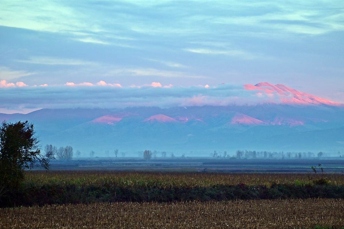
Falakro is a limestone mountain in the Drama regional unit of East Macedonia, with a ski centre high on its slopes, the Maara cave and its springs at its foot and the Rhodope forests of Paranesti and Stavroupoli to the east. The trip is one of the Greece Tours on Greece Ville, listed with the other Northern Greece tours.
This post covers what is on sale, where the mountain lies, the ski centre, the Maara cave, the villages on its slopes, the town of Drama, Paranesti and Stavroupoli and the questions that come up before booking.
What is Falakro?
Falakro is a mountain in the Drama regional unit, in eastern Greek Macedonia. Its highest summit, Profitis Ilias, rises to 2,232 metres above sea level. The mountain carries a ski resort, and the town of Drama sits at its foot.

The Greek name Falakro Oros translates into English as Bald mountain. In Bulgarian and Turkish the same massif goes by the name Bozdag, which translates as Gray mountain.
Falakro is the highest point of the whole Drama regional unit. It stands in the north of the unit, where the land along the Bulgarian border turns very mountainous, unlike the arable south.
A small part of a low northern offshoot crosses the border into Bulgaria. That strip lies just south of the village of Beslen, in the Bulgarian province of Blagoevgrad.
The highest ground of the massif inside Bulgaria is Chiplakbair, a forested peak of 1,090 metres. It sits right on the border between the two countries, far below Profitis Ilias.
The massif also shapes the land below it. The Angitis river has its source in the Falakro mountains near Prosotsani, and Drama grew at the foot of the mountain amid abundant water sources.
- Summit: Profitis Ilias is the name of the highest peak of Falakro.
- Country: Almost all of the massif lies in Greece, with only a very small part in Bulgaria.
- Winter use: A ski resort operates on the mountain.
- Park edge: The southern boundary of the Rodopi Mountain Range National Park starts on the north-east slopes of Falakro.
The sections below cover the nearest formats on sale, the setting of Falakro in the Drama regional unit, the ski centre, the Angitis caves, the villages, Drama town and the forests of the north-east.
Which Falakro tours are on sale?
Falakro has no tour of its own on sale. No listed format names Falakro, Paranesti or Stavroupoli. The boxes on this page show the nearest listed formats instead, and all of them start from Kavala, on the coast south of Drama.
The boxes below are therefore not Falakro tours. None of them climbs the mountain, stops at the ski centre, enters the Angitis caves or follows the road to Paranesti.
The three listed formats all begin in Kavala. One heads to Lake Vistonida and its floating monastery, one follows the sacred path of the Apostle Paul, and one visits ancient Philippi.
Drama, the town at the foot of Falakro, lies 37 km north of Kavala. The EO12 national road leaves the Drama regional unit towards both Kavala and Thessaloniki.
The link between the two towns is old. In the Ottoman era, a better road network towards the port of Kavala helped Drama grow, alongside the tobacco trade and the railway of 1895.
Of the three formats, the Philippi trip comes closest to the past of Drama. In the early Christian period, Drama was a small fortified settlement tied to the Roman colony of Philippi.
- Mountain formats: No listed tour names the mountain, Paranesti or Stavroupoli.
- Lake format: An outing from Kavala visits Lake Vistonida, its floating monastery and an old town.
- Private format: A private outing from Kavala follows the sacred path of the Apostle Paul.
- Philippi format: A trip from Kavala port reaches ancient Philippi with a local expert.
The tour cards and availability boxes on this page list live dates for each format, all from Kavala, and the Philippi tour post covers the ancient city in depth.
Where is Falakro?
Falakro rises in the north of the Drama regional unit, in eastern Greek Macedonia, close to the Bulgarian border. Its summit, Profitis Ilias, reaches 2,232 metres, the highest point in the unit, and its Greek name translates as Bald mountain.
The Drama regional unit is the northernmost unit of geographic Macedonia. It is also the westernmost unit of the East Macedonia and Thrace region, and Falakro stands in its north.
Four main ranges frame the unit. Orvilos rises in the north-west, Falakro in the north, the western Rhodopes in the north-east, with Frakto, Elatia and Koula, and Menoikio in the south-west.
Falakro stands above its neighbours. Gotsev Vrah, the top of Orvilos, reaches 2,212 metres, Mavromata on Menoikio 1,963 metres, and Delimposka, on Frakto, 1,953 metres.
Around the unit lie the regional units of Xanthi to the east, Kavala to the south and Serres to the west and south-west. To the north sit the Bulgarian provinces of Blagoevgrad and Smolyan.
Height changes the weather here. The south of the unit has a mainly Mediterranean climate, while the higher ground and the north, where Falakro stands, turn continental, with cold winters.
- Longest river: The Nestos is the longest river of the unit and flows through its north-east.
- Farmland: Arable land lies in the south and the west-central part of the unit.
- Menoikio rock: Menoikio, the south-western range, is mostly marble and almost entirely bare of forest.
- Population: The Drama regional unit counted 98,287 people at the 2011 census.
Kavala, on the coast south of Drama, sits on the Bay of Kavala across from the island of Thasos, the subject of the Thassos boat trip post.
What is the ski centre on Falakro?
Falakro holds a modern ski resort, listed as the ski centre of Falakro among the attractions of the municipality of Kato Nevrokopi, in the north-west of the Drama regional unit. Its seat, Kato Nevrokopi, ranks among the coldest places in Greece.
Drama has turned towards ecotourism in recent times, alongside tobacco farming, small-scale marble mining and forestry. The ski centre on the mountain forms part of that natural offer, high above the town.
Kato Nevrokopi has a humid continental climate, which only a handful of places in Greece share. Its winters bring cold and snow, and its summers turn warm to hot with a touch of humidity.
Readings of minus 20 degrees Celsius or lower have been taken there. A warming trend in recent years has made such cold rarer, and blizzards and thick winter fog have also been reported.
The EO57 national road links Drama with the municipality of the ski centre. It runs north through Kato Nevrokopi to the Bulgarian border near Exochi, where the crossing now passes through a tunnel.
The town of Drama has produced winter athletes. Among its notable people, Athanassios Tsakiris is a five-time Winter Olympian, and Panagiota Tsakiri is an Olympic biathlete and cross-country skier.
- Resort: A modern ski resort operates on Falakro.
- Municipality: Kato Nevrokopi lists the ski centre among its attractions for visitors.
- Hiking: Forest paths around Kato Nevrokopi open wide views for hikers.
- Lakes: The artificial lakes of Lefkogeia and Potamoi lie in the same municipality.
Beyond the ski centre, the Falakro massif also holds the source of the Angitis river, which the next section follows to its caves and gorge.
What lies in the Angitis caves below Falakro?
Falakro holds the source of the Angitis, a river that rises in the Falakro mountains near Prosotsani. At that source lies the Angitis cave, 21 km long, and finds from caves in the area show hunters living here in the mid-Palaeolithic.
The Angitis, a river of northern Greece, runs 75 km and ranks as an important tributary of the Strymonas. Its Bulgarian name is Dramatitsa, and it is also known as Angista.
From its source the river heads south as far as Fotolivos, the former seat of Sitagroi. There it bends west, crosses into the Serres regional unit and lower down joins the Strymonas near Tragilos.
The cave at the Angitis source lies at the village of Angitis, in the community of Kokkinogeia. It counts as a local attraction of the Prosotsani area, a former centre of tobacco production.
A short way from the cave, the Angitis gorge runs for 15 km. Its walls drop as deep as 100 m to the river bed, and the river serves as a setting for rafting.
The Archaeological Museum of Drama traces human life in the area back 50,000 years. It shows traces of Paleolithic hunts in the caves of the Angitis source and finds from the cave of Maara.
- Maara finds: Objects from the cave of Maara show nomadic hunters in the area in the mid-Palaeolithic.
- Neolithic house: The Drama museum shows a reconstructed Neolithic house with finds from daily work.
- Sitagroi: This village of the Prosotsani municipality holds an important late Neolithic and early Bronze Age site.
- Excavations: Digs at Sitagroi ran from 1968 to 1970, with reports edited by Colin Renfrew and Ernestine S. Elster.
From the Angitis source near Prosotsani, the focus moves to the villages around Falakro, from Kato Nevrokopi and Volakas to the traditional settlement of Granitis.
Which villages lie around Falakro?
Falakro shares the municipality of Kato Nevrokopi with villages such as Volakas, Perithorio, Lefkogeia, Ochyro, Kato Vrontou and Vathytopos, and with the traditional settlement of Granitis. Prosotsani lies near the Angitis source, and Drama sits at the foot of the mountain.
The municipality of Kato Nevrokopi lies in the north-west of the Drama regional unit. Before the 2011 reform it ranked as the largest municipality in all of Greece, at 873.552 km2.
Its seat, Kato Nevrokopi, is home to 1,855 people, and Volakas comes second with 783. Perithorio has 569 residents, and Lefkogeia, Ochyro, Kato Vrontou and Vathytopos follow in that order.
Granitis, a village of only 55 residents, keeps a traditional settlement. The municipality also lists the historical bunker of Lise, the forest routes and the old churches among its attractions.
Monastiri and Mavrochori stand abandoned within the municipality, and they are not its only empty villages. The area is known for its local potatoes and beans, grown through very cold winters.
The town of Kato Nevrokopi carried the name Zyrnovo until 1927. After the Asia Minor Catastrophe, large numbers of Greek refugees from Asia Minor and from nearby Nevrokop settled there.
- Bulgarian side: The village of Beslen, in Blagoevgrad Province, lies just north of the small Falakro offshoot in Bulgaria.
- Prosotsani: The town of 3,169 people stands at the foot of Menekio mountain.
- Former name: Prosotsani carried the name Pyrsopolis from 1925 until 1940.
- Sidironero: This village between Kato Nevrokopi and Paranesti lies in the Rhodope Mountains along the Bulgarian border.
The villages give way to the town at the foot of Falakro, and the next section turns to Drama, its museums, its festivals and its long Byzantine and Ottoman past.
What is Drama, the town below Falakro?
Falakro rises above Drama, a city of 44,257 people at the 2021 census and the capital of the Drama regional unit. The town grew at the foot of the mountain, and its ancient Greek name meant rich in water.
Archaeological finds show an ancient Greek settlement on the site, called Dyrama or Hydrama. Over time Dyrama became Drama, and Hydrama served as a place of worship for Dionysos, Apollo and Artemis.
Around the 10th century, Drama was heavily fortified and thrived as a military and commercial hub, and it prospered further under the Komnenoi. The Hagia Sophia church rose in that century, together with the city walls.
The Ottomans took Drama in 1383, and Hagia Sophia later served as a mosque. Bulgarian troops seized the town in 1912, and after the Treaty of Bucharest in 1913 it became part of Greece.
During the Second World War, Bulgarian forces occupied Drama from 1941 to 1944. On 4 March 1943, 589 Jews from Drama were rounded up and later sent to the Treblinka extermination camp; none returned.
Drama has hosted the Drama International Short Film Festival since 1978. The town also marks its liberation with the Eleftheria, a run of cultural events at the end of June or early July.
- Archaeology: The Archaeological Museum of Drama spreads its collection over three main halls.
- Railway: Drama station opened in June 1895 on the line between Thessaloniki and Alexandroupoli.
- Rail museum: The old station warehouse now houses the Drama Railway Museum.
- Icons: The Ecclesiastical Museum keeps 13th-century icons of the Virgin Hodegetria and the Blessing Lord.
From Drama, the EO14 national road heads east to Paranesti and Stavroupoli, and the next section follows it into the Rhodope forests beyond Falakro, towards the Nestos valley.
What do Paranesti and Stavroupoli add to a Falakro trip?
Falakro anchors the southern boundary of the Rodopi Mountain Range National Park, and Paranesti lies in the Rhodope Mountains of the north-east Drama regional unit. The EO14 road joins Drama with Paranesti and Stavroupoli on its way to Xanthi.
The national park spans about 170,000 hectares in the Greek Rhodopes. It holds the largest forest ecosystems in Greece, and its northern line follows the Bulgarian border from near Kato Nevrokopi to near Dimario.
Paranesti is the seat of a municipality of 1029.392 km2 with two units, Paranesti and Nikiforos. The village has 625 residents, a railway station and the Natural History Museum of Paranesti.
Frakto forest, near the Bulgarian border, holds trees 300 years old and over 50 metres high. The endangered wild goat lives there, in a region left ungrazed for more than 50 years.
The forest village of Elatia lies 72 km from Drama, inside Karantere, an area 90% covered by forest. Karantere holds the only spruce forest in Greece and more than 700 plant species.
Stavroupoli, a village of 1,635 people in the Xanthi regional unit, lies on the EO14. With the Nestos Valley and the Nestos River Tempi, it forms a popular tour region of northern Greece.
- Flora: The park records 827 plant species, among them the endemic Lilium rhodopeum.
- Railway: Paranesti station opened in June 1895 and became a listed cultural monument in 2015.
- Thisavros Dam: This 172-metre rock-fill dam on the Nestos, the tallest in Greece, lies 21 km north-east of Drama.
- Nestos: The river runs 230 km, 126 km of it in Bulgaria, and divides the Kavala and Xanthi regional units after crossing Drama.
Stavroupoli has formed part of the Xanthi municipality since the 2011 reform, and the Xanthi tour post covers the city at the eastern end of the EO14 road.
What do travellers ask about Falakro?
Falakro draws four recurring questions from travellers: how high the summit stands, what the name means, how close the railway runs and which animals live in the park on its slopes. The answers below repeat the key facts in short form.
How high is Falakro?
Profitis Ilias, the highest summit of Falakro, stands 2,232 metres above sea level, the top of the Drama regional unit. The mountain stays far higher than Chiplakbair, its forested Bulgarian peak of 1,090 metres, and edges out Gotsev Vrah on Orvilos, at 2,212 metres. Mavromata on Menoikio stops at 1,963 metres.
What does the name Falakro mean?
The Greek name Falakro Oros translates as Bald mountain. In Bulgarian and Turkish the massif is Bozdag, or Gray mountain. The Turkish name Boz Dag also once applied to Menoikio, the range in the south-west of the regional unit, which locals know as Bozdakas or Bozdas, Greek forms of the Turkish name.
Can Falakro be reached by train?
Rail reaches the foot of Falakro at Drama station, on the line from Thessaloniki to Alexandroupoli, 2 km south of the town. Paranesti, further east, has its own station on the same line, and the Drama-Xanthi national road passes right in front of it. Both stations opened in June 1895.
What wildlife lives near Falakro?
The national park that begins on the north-east slopes of Falakro records 57 mammal species, among them brown bear, grey wolf, wild boar and roe deer, with chamois on high ground. Its 139 bird species include the golden eagle and the endangered Egyptian vulture, and the hazel grouse shares the forest with the western capercaillie.