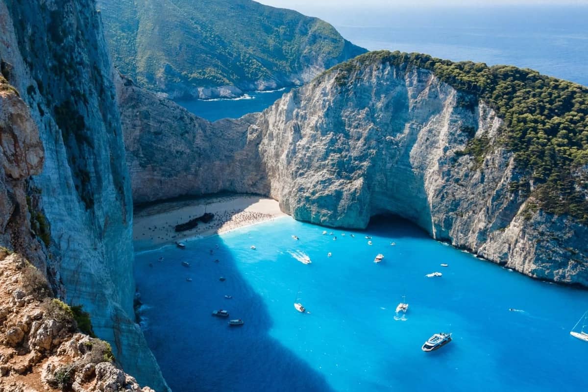
A Navagio shipwreck tour is a boat trip to Navagio, the cove with a rusted wreck on the north-west coast of Zakynthos. White cliffs close the cove on three sides. It is one of the Greece Tours on Greece Ville.
This post covers what a Navagio shipwreck tour is, how the cliffs and cove formed and why the water is so clear. It also covers the wildlife, the north-west coast and the Ionian Sea. The history of Zakynthos, the best time of year and common questions come last.
The sections include Navagio shipwreck tours and related Zakynthos boat trips that can be booked online.
What is a Navagio shipwreck tour?
A Navagio shipwreck tour is a trip to Navagio Beach on the coast of Zakynthos. The cove can be reached only by sea or by air. It lies 34.5 km from Zakynthos town. Its position is 37.8596° N, 20.6245° E.
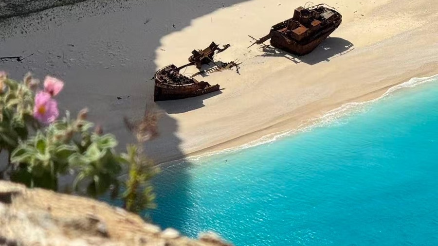
Before the wreck, the cove of a Navagio shipwreck tour had another name. It was known as Agios Georgiou Sta Gremna, or St George of the Rocks. A monastery on the cliff above gave it that name.
The beach of a Navagio shipwreck tour has no pier, so boats cannot tie up there directly. A small platform on the cliff top is the only land spot with a view of the wreck.
Parachute jumpers and rope jumpers leap from a popular viewpoint above the cliff. Crowds on the sand were once huge. Until 2019, up to 4,000 people a day visited the beach in summer.
In 2018 a jury of 1,200 tourism professionals named Navagio the world’s best beach. Yet the cove of a Navagio shipwreck tour has a fragile ecosystem. The Church of Greece, public bodies and private owners also clash over the area.
The steep west coast of Zakynthos is part of the Natura site GR2210001. Its name is the Western and North-eastern Coasts of Zakynthos. Sea makes up more than three quarters of this protected site.
- 1996: The coast was first proposed as an EU Site of Community Importance.
- 2002: Greece classified it as a Special Protection Area for birds.
- 2011: It became a Special Area of Conservation under Greek Law 3937.
The site record warns of an uncontrolled rise in visitors and leisure boats along this coast. New roads to once remote beaches add a fresh threat from land.


How did the cliffs and cove form for a Navagio shipwreck tour?
A Navagio shipwreck tour enters a cove below steep limestone cliffs. Navagio sits on the western side of the Vrachionas anticline, an upward fold in the rock layers. Over time, waves piled up sand and pebbles and made the beach bigger.
A major thrust fault splits Zakynthos into the western Paxoi unit and the eastern Ionian unit. The Vrachionas anticline formed in the Pliocene, when the crust was squeezed next to the Ionian thrust.
The anticline is built of limestones and dolomites from the Late Cretaceous to the Oligocene. The cliffs seen on a Navagio shipwreck tour are compact limestone with no layers.
This limestone lets water through fairly well, yet it is very strong. Small patches of travertine, a limestone formed in lakes, appear on the cliff faces. Limestone covers about half of Zakynthos.
Three major normal faults break up the rock around the beach of a Navagio shipwreck tour. The main fault runs east to west and dips steeply south. On the southern slope two faults cross and form a zone packed with cracks.
The raised side of the main fault has lost the largest share of rock. A lifted block falls apart more easily. Between two drone surveys three years apart, the fastest-changing cliff sections lost more rock than they gained.
- Cove: Softer rock wears away faster than harder rock, leaving a round bay with a narrow mouth.
- Pocket beach: A beach between two headlands swaps little or no sand with the shores beside it.
- Colour: Limestone is commonly white to grey, and traces of iron or manganese tint it yellow or red.
Sparse plants hanging from the top of the Navagio slope hold back part of the loose rock. Faults, falling rock and waves all shaped the cove of a Navagio shipwreck tour.
Why is the water so clear on a Navagio shipwreck tour?
A Navagio shipwreck tour crosses clear, turquoise water. Small white stones run from the beach into the sea and give the water its strong colour. Plant growth in Mediterranean surface water is also very low between June and October.
The sea of a Navagio shipwreck tour is already deep just metres from the shore. Its colour ranges from light blue to intense electric blue.
In summer, warm surface water is almost cut off from the water below. So hardly any nutrients reach it. Tiny plankton, mainly picophytoplankton and bacteria, rule the Mediterranean because so little grows there.
Mediterranean water holds 24 to 29 parts nitrogen for each part phosphorus. The usual ocean ratio is about 16, so phosphorus runs short. In summer the layer richest in chlorophyll lies deep below the surface.
Posidonia seagrass beds cover about 2,142 hectares of the Natura 2000 site off Zakynthos. The site record grades them A, the top mark for how typical, well kept and valuable they are.
A swimming pool with a white bottom looks cyan even indoors. The deeper the pool, the stronger the colour. Water with no particles to scatter light swallows it all within tens of metres and looks black.
- Orange and yellow: The sea absorbs orange light by about 40 metres and yellow before 100 metres.
- Blue: Blue light can reach 200 metres down.
- Sunlight: Only 1% of sunlight is left at 100 metres, and none gets below 1,000 metres.
Pure water has a faint blue colour from vibrations of its molecules. Stones, depth and light together shape the blue seen on a Navagio shipwreck tour.
Which wildlife lives near a Navagio shipwreck tour?
A Navagio shipwreck tour passes sea cliffs, caves and open water. Falcons and wild doves use the cliffs for hunting and nesting. Dolphins and loggerhead turtles swim in the sea below. A very rare cliff plant also grows at Navagio itself.
Eleonora’s falcon hunts by cruising along coastal cliffs with steady wingbeats. It watches for tired migrant birds arriving from the sea. Researchers found it trapping live small birds in rock crevices to eat later.
The peregrine falcon is another cliff hunter along a Navagio shipwreck tour. It lays its eggs in a shallow, bare cliff-edge scrape. As of 2018, its hunting dive held the falcon speed record, nearly 390 km/h.
On a Navagio shipwreck tour coast, wild rock doves nest in crevices of sea cliffs and caves. This bird is the ancestor of the domestic pigeon, which now has about 1,000 breeds.
The monk seal also lives in the sea of a Navagio shipwreck tour. In Greek seas, its births run from August to December. Each mother has only one pup.
Plants that can live only on cliffs are called obligate chasmophytes. Greece has 476 of them, about 7% of its wild plants. From 2014 to 2018, Asperula naufraga counted only 68 to 130 mature plants worldwide.
- Striped dolphins: They can dive to 700 m to hunt deep-water prey.
- Loggerhead turtles: In the coldest months, one can stay underwater up to seven hours.
- Common dolphins: A newborn calf is 70 to 100 cm long and weighs about 10 kg.
The cliffs seen on a Navagio shipwreck tour hold Asperula naufraga. It flowers from early June to late July, 59 days on average. At Navagio, hiking, rock climbing and plant picking near the trails threaten it.
What does the north-west coast show on a Navagio shipwreck tour?
A Navagio shipwreck tour on the north-west coast shows Cape Skinari and the islet of Agios Nikolaos. Inland, villages such as Volimes, Orthonies and Gyri keep their old churches. A monastery and Venetian records add a long local history.
On a Navagio shipwreck tour, Cape Skinari is a north-west landmark. It lies 15.6 km, or 8.5 nautical miles, from Cape Mounta. That cape is the southern tip of Kefalonia.
The Navagio shipwreck tour area also has mountain villages. Volimes sits at 430 m on the northern slopes of Mount Vrachionas. In 1866 it became the seat of the municipality of Volimes.
Venetian records show the church of Agia Thekla, near Ano Volimes, belonged to Anafonitria monastery in 1491. The church has only one small square opening, in its apse, or curved end.
A local story says Orthonies got its name from three young women. They stayed standing while serving a meal to the island’s rulers. The village’s Taxiarches church and bell tower survived the 1953 earthquakes.
The Monastery of Spileotissa lies 2 km from Orthonies. The monk Ioannikios Katsivas founded it in the mid-16th century. Its old icon of the Virgin was found in a cave at the foot of Mount Kentro.
- Agios Nikolaos: Guards in its old Venetian lookout watched ships between Kefalonia, Zakynthos and the Peloponnese.
- Gyri: At 570 m, it is the highest inhabited village on Zakynthos.
- Agios Leon: Settlers from Bastas, in Messenia, came after Koroni castle fell in 1534.
The church of Prophet Elias in Gyri was rebuilt just after the 1953 earthquakes. It copied the older church, renovated in 1887. The pine forest around Agios Leon burned down on 26 August 2011.
What is the Ionian Sea like on a Navagio shipwreck tour?
A Navagio shipwreck tour crosses the Ionian Sea, part of the Mediterranean. Its tides stay small. Deep below, moving plates have built a long undersea ridge. Strong earthquakes and even a tsunami have struck Zakynthos in its history.
The Mediterranean, the wider sea of a Navagio shipwreck tour, has relatively small tides. Its natural sloshing rhythm does not match the pull of the Moon and Sun. Its largest tides occur near its narrow link with the Atlantic.
The Ionian Sea of a Navagio shipwreck tour meets the Adriatic at the Strait of Otranto. This strait is less than 72 km wide. The whole Adriatic volume is exchanged through it in about 3.4 years.
Zakynthos, the island of a Navagio shipwreck tour, sits on the Ionian Islands–Akarnania Block. This piece of crust forms the backstop, or solid rear edge, of the Mediterranean Ridge.
The Mediterranean Ridge is a curved undersea ridge about 1,300 km long and 150 to 300 km wide. It runs from Calabria past the south of Crete to south-west Turkey.
The 1953 earthquake reached intensity X, or extreme, on the Mercalli scale. The 1953 earthquakes destroyed 27,659 of the 33,300 buildings on Kefalonia, Zakynthos and Ithaca. They injured 2,412 people.
- Plates: The ridge forms as the African Plate sinks under the Eurasian and Anatolian plates.
- L’Atalante: It is one of five deep basins of oxygen-free salty brine along the ridge.
- Name: A legend names the sea after Ionius, thrown in after Heracles killed him by mistake.
A magnitude 6.8 earthquake struck on the night of 25 to 26 October 2018. It hit 14 km below the seabed, south-west of Zakynthos. About 120 homes became uninhabitable, but no one was seriously hurt.
What is the history of Zakynthos for a Navagio shipwreck tour?
A Navagio shipwreck tour crosses an island with a long past. Neanderthal stone tools show that people lived on Zakynthos about 110 thousand years ago. A Mycenaean cemetery near Kampi, a west-coast village, shows settlement in the Mycenaean age.
The ancient writer Pausanias said the hilltop fort, or acropolis, of ancient Zakynthos was named Psophis. In 430 BC about 1,000 Spartan heavy infantry under the admiral Cnemus burned much of the countryside. The city still refused to surrender.
A Navagio shipwreck tour also visits an island with medieval history. In 1185 Margaritus of Brindisi captured Zakynthos. It joined the County Palatine of Cephalonia and Zakynthos. Sea explorer Juan de Fuca died there in 1602.
Crete fell to the Ottomans in 1669. The Ionian school of painting then became the leading Greek painting school. In 1726 the painter Panagiotis Doxaras wrote “On Painting”. It urged Greek art to turn from Byzantine models toward western European art.
After Venice fell in 1797, the common people, the Popolari, rose against the nobles. They burned the Libro d’Oro, the book of noble families. When Dionysios Solomos was born in 1798, Zakynthos belonged to Mer-Égée, a French department.
- British flag: On 20 February 1801 Zakynthos left the Septinsular Republic and raised the British flag.
- Poet: Andreas Kalvos, born on Zakynthos in 1792, published Lyra in 1824.
- Union: In 1864 the British left, and the Ionian Islands joined the Kingdom of Greece.
In 1889 the town of Zakynthos had 18,906 people, out of 44,070 on the island. The old Venetian archive, the Archeiophylakeion, was lost in 1953 in the earthquake and a great fire.
When is the best time of year for a Navagio shipwreck tour?
A Navagio shipwreck tour suits the warm, sunny months best. July is the sunniest month on Zakynthos, with about 12 hours of sunshine a day. In September the sea around the island is still warm, at about 23 °C.
August gets about 11 hours of sunshine a day, and June about 10. September gets about 9 hours. October drops to about 7 hours a day. December and January get only about 4.
A Navagio shipwreck tour in spring meets cooler water. In April the sea around Zakynthos averages only about 14 °C. In October it still averages about 20 °C. By November the sea cools to about 17 °C.
In summer a north-westerly wind blows on Zakynthos almost every day. It lasts from the afternoon into the evening. A Navagio shipwreck tour in the morning sails before this wind rises.
In autumn, strong storms arrive as squall lines, long bands of storms. Rain is plentiful from November to January. Air over the warm Ionian Sea soaks up moisture. Clouds moving east then hit the Greek west coast first.
- January: The average low is 8.1 °C, and the record low is −2.6 °C.
- March: The average high is 16.1 °C and the low 9.2 °C.
- December: The average high is 15.8 °C and the low 9.6 °C.
A Navagio shipwreck tour in winter meets cool air, short days and rain. Summer and early autumn bring sunny days and warm water. Even October has a record low of 5.2 °C.
What do travelers want to know about a Navagio shipwreck tour?
A Navagio shipwreck tour raises questions about safety, travel and the sea. On 13 September 2018 a rockfall at Navagio injured 7 people, 2 of them children. Travelers also ask how to reach the island and what lies nearby.
Have rockfalls hit boats on a Navagio shipwreck tour?
Yes. The rockfall struck at about 11:15 am. A woman from the Czech Republic went to hospital with back pain. Six other people had minor injuries. Witnesses said waves from the falling rock turned over boats close to the beach.
What did witnesses see from a Navagio shipwreck tour boat?
One boat owner said his group had finished a swim. They were back on board when rocks fell just 20 m away. Another witness heard a small piece of rock fall, then a second. Then a third, large piece dropped into the sea.
Why do cliffs drop rocks near a Navagio shipwreck tour?
Weathering, ground and surface water, root-wedging and outside stresses cause rockfalls from cliffs. Root-wedging means roots split rock apart. In lower, warmer mountains, weathering can cause rockfalls without frost. Fallen rock collects at the cliff foot as talus or scree, a slope of loose stones.
How does a traveler reach Zakynthos for a Navagio shipwreck tour?
Zakynthos has an airport owned by the Greek state. A ferry also links the island with Kyllini. In 2002 that route carried 987 thousand passengers, the fifth busiest in Greece. Patras lies about 70 km east-north-east of Zakynthos. Athens lies about 300 km to the east.
How warm is the sea for a Navagio shipwreck tour across the year?
The sea around Zakynthos is warmest in August, at about 25 °C. It is coldest in January and February, at about 12 °C. In March it averages about 13 °C. In December it still averages about 16 °C. A winter swim feels cold.
What other sights lie on Zakynthos beyond a Navagio shipwreck tour?
Near Kampi, the deep bay of Porto Schiza has pale cliffs. They drop about 200 metres straight into the sea. A white cross above the cliffs at Kampi remembers the victims of the Greek Civil War. Liquid tar once seeped out of the ground at Porto Vromi.