
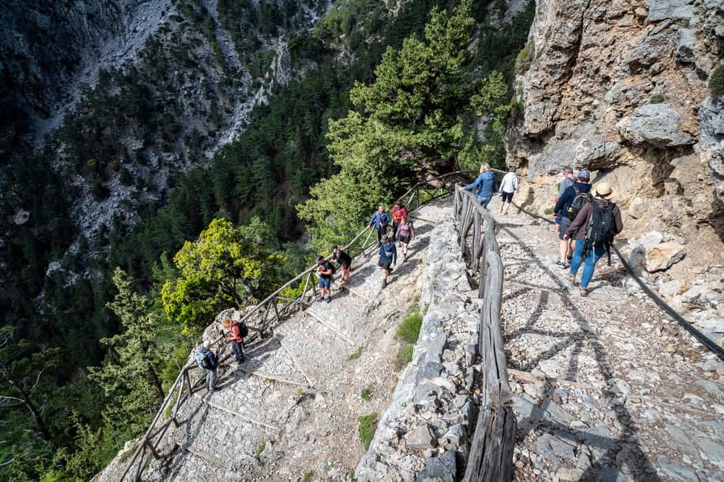
A Samaria gorge tour walks the Samaria gorge in the White Mountains of west Crete, down to Agia Roumeli on the Libyan Sea. The tour is one of the Greece Tours on Greece Ville, listed with the other Crete tours and Greece hiking tours.
This post covers the national park, how water cut the gorge, its springs, its rare plants, its small animals and its mammals.
Ancient Tarra, the story of the park, the old churches, the legs on the way down, the Libyan Sea, floods and rockfalls, visitor numbers, the best months and common questions come last. The sections include Samaria gorge tours that can be booked online.
What is a Samaria gorge tour?
A Samaria gorge tour crosses a national park, one of the earliest declared in Greece. The park holds a Category A diploma from the Council of Europe. Council of Europe flags fly at both entrances of the gorge.
Under Greek law, a national park is created by presidential decree, an order the president signs. The law also says that a special environmental study must come before such a decree.
The Council of Europe has asked Greece to sign a presidential decree that is still pending. That decree fixes the new boundaries of the park that a Samaria gorge tour crosses.
In 2021, a ministerial decision banned the building of new roads in the park for two years. The ban covered 382.06 km², which is about 65% of the whole 585 km² park.
A Samaria gorge tour runs through a UNESCO biosphere reserve that covers 58,484 hectares around the gorge. The reserve reaches past the shore, because its total includes 4,552 hectares of sea.
- No conditions: The Council of Europe gave the Category A diploma without conditions.
- Diploma renewal: Resolution CM/ResDip(2019)9, the latest renewal, was adopted on 21 November 2019.
- Natura 2000: Site GR4340014 joins Samaria National Park with the Tripiti gorge, Psilafi and Koustogerako.
On 7 April 1960, the people of Samaria and Agia Roumeli gave their word of honour. In that pledge, they promised to protect the agrimi, which is the Cretan wild goat.


How did water carve the walls of a Samaria gorge tour?
A Samaria gorge tour passes walls carved by rainwater running off the slopes and later by spring water. This water wore down the rising rock and dug the deep gorge. Crete rose 1 to 2 km over the last 2 million years.
The rocks of the Lefka Ori mountains formed on the sea floor. Along a Samaria gorge tour, rock types change from place to place, so erosion runs at different speeds.
Water slowly dissolves calcium carbonate, a mineral in the bulk of Lefka Ori rocks. Known as karst erosion, this process helped shape the Lefka Ori gorges, plateaus and more than 1,400 caves.
Old dated shorelines show western Crete rising 2.5 to 2.7 mm a year over the long term. Between 42 and 23 thousand years ago, western Crete sank instead, by 2.6 to 3.2 mm a year.
From 23 thousand years ago to today, western Crete rose about 7.7 mm a year. Over the last 5 thousand years, western Crete has risen 3.0 to 3.3 mm a year.
A 2001 study proposed that rocks along a Samaria gorge tour form an anticline, an arch-shaped fold. The axis of this fold runs NNE–SSW, which means from north-northeast to south-southwest.
- Gigilos formation: This gorge-area rock unit is mainly phyllite and slate, two thin-layered rocks.
- Folding: Squeezing forces folded the local rocks, cracked them along faults and tilted the layers steeply.
- Canyon cliffs: Cliffs form where hard rock layers resist erosion and stay exposed on valley walls.
- Frost wedging: Water that freezes in cracks pushes rock apart and breaks chunks off canyon walls.
Rivers in canyons formed by slow uplift are called entrenched rivers, because they cannot easily change course. A plunge pool is a deep hollow ground into a stream bed by falling water and swirling stones.
Which springs and streams flow along a Samaria gorge tour?
A Samaria gorge tour follows a stream that starts about 2 km north of the old Samaria settlement. In places, the stream sinks underground and comes back up lower down. From the Kefalovrysia spring, it flows along its bed all the way to the sea.
In the wet season, the stream collects large amounts of water from all the land draining into it. In the dry season, a small number of springs along a Samaria gorge tour feed the stream.
The springs rise from carbonate rocks with silica-rich layers, changed by heat and pressure. They belong to the Plattenkalk Group. Underground water follows paths first opened by faults, then widened as the rock dissolved.
Besides the large Kefalovrysia spring, the springs on a Samaria gorge tour are contact and overflow springs. The village of Agia Roumeli takes its water supply from the Kefalovrysia spring.
Mytatouli spring gave 12.50 m³ an hour in late spring 2022 and 5.26 m³ in September. Potistiria spring stayed strong, easing from 7.14 to 5.26 m³ an hour between late spring and September 2022.
Sykia spring fell from 1.58 m³ an hour in late spring 2022 to nothing by September. Neroutsiko spring dropped from 2.12 to 0.43 m³ an hour over the same months.
- pH: The spring water measured pH 7.6 to 8.0, so it is slightly alkaline.
- Temperature: The temperature of the spring water ranged from 8.5 to 16.5 °C.
- Tomography: Scientists scan the ground with electrical tomography to track seawater seeping in at the gorge.
- Lefka Ori: Plane-tree forests grow mainly on wet spots of the Samaria and Agia Eirini stream beds.
In 1983, a Council of Europe inspection of the park had to be put off more than once. The cause was that the only passage through the gorge was flooded.
Which rare plants grow along a Samaria gorge tour?
A Samaria gorge tour crosses the White Mountains, home to half the plant species found only on Crete. Bupleurum kakiskalae, one of Crete’s rarest plants, grows on lime-rich cliffs at 1450-1500 m. It flowers and fruits only once, then dies.
Bupleurum kakiskalae grows at Kakia Skala, on Linoseli, a summit near a Samaria gorge tour. Each plant forms one rosette, a ring of narrow blue-green leaves. It flowers after three to twelve years.
Its branched flower stem grows up to one metre tall and carries yellow flowers in late summer. The bulk of its seed falls below the cliffs, where goats destroy the seedlings.
The orchid Cephalanthera cucullata grows in the White Mountains of a Samaria gorge tour at 700-1500 m. It grows only on Crete. The world nature body IUCN lists it as endangered.
The EU Habitats Directive names Cephalanthera cucullata a priority species, one of only two orchids with that status. Since 1992 it has also listed Bupleurum kakiskalae as a priority species.
In antiquity, Cretan dittany decorated temples and gardens and served as a cure-all and a love potion. In Virgil’s Aeneid, Venus heals Aeneas with a dittany stalk picked on Cretan Ida.
- Nepeta sphaciotica: This scented shrub grows only on Svourichti’s north side, at 2200-2300 m.
- Clematis elisabethae-carolae: This plant grows in only two places on Amoutsera, at 1850 m.
- Myosotis solange: This White Mountains plant grows in one location, on Mount Agio Pneuma.
- Thlaspi zaffranii: It has only three recorded sites: Gkigkilos, Volakias and Anopoli of Sfakia.
A new species, Anthemis samariensis, was found in 2007 on a slope of the White Mountains. So the plant list of the range around a Samaria gorge tour is still incomplete.
Which small animals live along a Samaria gorge tour?
A Samaria gorge tour crosses the home of Macrothele cretica, a spider found only around Samaria National Park. The IUCN protects this rare invertebrate, or backboneless animal, worldwide. The Cretan tarantula has been seen in Lefka Ori rock crevices.
Described in 2019, the Cretan tarantula was the first tarantula reported in Greece. It is only the second tarantula found in Europe. Its name honours Petros Lymberakis, a curator of vertebrates.
The jumping spider Aelurillus cretensis lives up to 2,000 m high around a Samaria gorge tour. The hard upper shell of its front body measures only 2.9 to 3.2 mm.
The cave amphipod Niphargobates lefkodemonaki, a shrimp-like crustacean, is known from only one Lefka Ori cave. The IUCN Red List rates it as vulnerable, at high risk of dying out.
Coenonympha thyrsis, a small butterfly of the browns family, lives only on Crete. The Cretan frog was recognised as its own species in 1994, after genetic tests on 41 specimens.
The frog split from marsh frogs about 5.4 million years ago, when the sea isolated Crete. Cretan frogs along a Samaria gorge tour reach up to 8 cm and 40 g.
- Eggs: A female can lay up to 5000 eggs, which hatch after about a week.
- Lifespan: It lives six to eight years, eating mainly water insects, snails and small crustaceans.
- Cretan wall lizard: It was first described in 1952, as the subspecies Lacerta erhardii cretensis.
- Balkan green lizard: It is the widest-spread lizard of the Balkans, Europe’s south-east peninsula.
In Greece, Balkan green lizards breed from April to July and mature at about 80 mm. The Balkan whip snake lives on Crete, in stony areas, scree, scrub, open woodland and ruins. Genetic tests show the Cretan wall lizard is closely related to Podarcis peloponnesiacus.
Which mammals besides the kri-kri live in the park of a Samaria gorge tour?
A Samaria gorge tour crosses the home of the Cretan shrew, Crete spiny mouse and badger. Scientists made the shrew a full species in 1986. It has 34 pairs of chromosomes, the gene carriers in cells, instead of 40.
The leading view says the shrew rafted across the sea in the early Pleistocene, an ice-age era. It outlived Crete’s dwarf elephants, eight Candiacervus deer species and the Cretan otter. Unlike other island mammals, it never grew larger over time.
Owls and other birds of prey are its main predators along a Samaria gorge tour. Owl pellets, coughed-up food balls, show it is over ten times rarer than the lesser white-toothed shrew. People brought that shrew to Crete around 1500 BCE.
The Crete spiny mouse along a Samaria gorge tour has coarse, stiff hairs and a pointed face. A spiny mouse pregnancy lasts five to six weeks, unusually long for a mouse.
Other females clean and help a mother at birth, and her young are born with open eyes. The mouse comes in three chromosome forms, with 38, 40 or 42 chromosomes, which interbreed.
The Cretan wildcat has dark rings on its tail and is much larger than the common cat. It is protected by CITES, the Washington Convention on trade in endangered species.
- Cretan badger: It is Meles canescens arcalus, a subspecies of the Caucasian badger.
- Beech marten: Martes foina bunites lives on Crete, Naxos and Karpathos, among other islands.
- Bats: Crete’s bats include Blasius’s horseshoe bat, the lesser mouse-eared bat, Geoffroy’s bat and the serotine.
- Hedgehog: The northern white-breasted hedgehog has substantial populations on the island of Crete.
In the 1980s, Colin Groves judged the two Cretan wildcat skins in collections to be feral cats. Beech martens are active at dusk and at night, above all on moonlit nights.
What did the ancient city of Tarra leave on a Samaria gorge tour?
A Samaria gorge tour reaches Tarra, which left part of a double city wall. The wall had square and round towers. Stone slabs called stelae, carved with a double axe, lay there. One is now in Chania’s Archaeological Museum.
In the leading view, Tarrha, or Tarra, was founded in the Classical period. It grew into a very important religious centre. It was one of the earliest sites of Apollo worship.
In the myths behind a Samaria gorge tour, Apollo came to Tarrha after killing the serpent Python. There, the temple priest Carmanor cleansed him. Carmanor’s child Chrysothemis reportedly won the first Pythian Games contest at Delphi.
Pausanias wrote that Apollo and Acacallis had two sons in Carmanor’s house. In 1415, Cristoforo Buondelmonti found a Greek inscription in Apollo’s ruined temple. It asked visitors to remove their shoes and cover their heads.
Tarra, a city on a Samaria gorge tour, served as the port of ancient Elyros. Tarrha also shared a monetary union, or common coin system, with Elyros, Hyrtakina and Lissos.
Tarrha’s coins showed a Cretan wild goat’s head, an arrow and a bee. They date to the 3rd and 2nd centuries BC, when Tarrha belonged to the Republic of Cretans.
- League: Tarra joined the Oreioi, a mountain league, in the 3rd century BC.
- Colony: Tarrha founded a colony with the same name in the Caucasus.
- Scholar: Lucillus of Tarrha, a 1st-century AD writer, wrote a commentary on the Argonautica.
- Explorer: Robert Pashley was the first modern archaeologist to find and study Tarrha.
In 1959 Gladys Weinberg dug at Agia Roumeli and found a woman’s 5th-century BC tomb. Glass fragments there suggest glass-working workshops at Tarra. The city was abandoned around the 6th century AD.
How did the national park of a Samaria gorge tour come to be?
A Samaria gorge tour crosses a park built on Greece’s first law on national parks. Ioannis Metaxas’s government issued that law, Law 856/1937 on National Woodland Parks. Samaria National Woodland Park has a core zone of 47.52 square kilometres.
The whole park is state-owned land. No wood has been cut there since the 1960s. It belongs to the European Network of Biogenetic Reserves. It is listed as an Important Bird Area.
In 1979, Council of Europe Resolution (79) 14 gave the park the European Diploma, in category A. The Council of Europe renewed the diploma in 1984, 1989, 1994 and 1999.
Law 1650/1986 later overhauled the legal rules for Greek protected areas, including national parks. A management plan for the park of a Samaria gorge tour was also drafted in 1986.
In the German occupation of the Second World War, the kri-kri, a wild goat, was guerrillas’ only meat. In 1987 the park held about 400 wild goats. By 1994 they numbered an estimated 1200.
Law 3044/2002 set up a management body for the park of a Samaria gorge tour. It hired its first staff in April 2008. NECCA, Greece’s nature and climate agency, later took it over.
- Fence: A long fence in the upper park kept domestic goats away.
- Staff: By 1994 the park employed 34 people, seven of them wardens.
- Natura 2000: The park is a Special Protection Area for birds, code GR4340014.
- Gazette: NECCA’s takeover appeared in Government Gazette 965/B on 3 March 2022.
In 2003 the park covered only 4,850 hectares. Planners proposed extending it to 24,542 hectares. In the 2012-2013 school year, 1211 pupils from 24 schools joined its environmental education programme.
Which old churches stand along a Samaria gorge tour?
A Samaria gorge tour passes Osia Maria and the ruins of an Early Christian basilica at Agia Roumeli. Osia Maria is a Byzantine church dedicated to Saint Mary of Egypt. Its murals, or wall paintings, date from the 14th century.
On a Samaria gorge tour, Osia Maria shows one aisle, or long hall, under an arched, barrel-vaulted roof. It belongs to the Holy Metropolis, or diocese, of Lambi, Syvritos and Sfakia.
Saint Mary of Egypt’s life story tells how the monk Zosimas met her near the Jordan River. Sophronius, Patriarch of Jerusalem, is credited with writing her Life in the 7th century.
The Agia Roumeli basilica had three aisles, a wooden roof and a narthex, or entrance hall. It was built over an older church’s ruins. Its 6th-century floor mosaic shows geometric shapes and circles.
Inside the basilica’s sanctuary, or altar area, stands a single-aisled, barrel-vaulted church with 15th-century murals. The parish of Agia Roumeli is dedicated to the Holy Trinity, Agia Triada in Greek.
Along a Samaria gorge tour, the Saint Paul church stands on the coast east of Agia Roumeli. It dates from the early 11th century. It is linked to Saint John Xenos. The archaeological service carried out small repairs there in 1961.
- Founder: John Xenos, a wandering hermit born around 970, founded churches on Byzantine Crete.
- Frescoes: Saint Paul’s wall paintings date from the 13th to 14th centuries.
- Chapels: In a number of cases, Samaria’s chapels stand on ancient temple sites.
- Damp: In 2008 damp was damaging Saint Paul’s walls and paintings, and parts had fallen.
The Orthodox Church honours Saint Mary of Egypt on 1 April. It also honours her on the 5th Sunday of Great Lent, the fast before Easter. Osia Maria’s diocese became a Metropolis in 1962.
What makes the downhill walk of a Samaria gorge tour hard on the legs?
A Samaria gorge tour strains the legs because downhill walking makes the thigh muscles work as brakes. These muscles lengthen while they contract, which is called an eccentric contraction. Lengthening contractions cause more muscle damage than shortening contractions.
Muscles are about 40% stronger in eccentric contractions than in concentric, shortening ones. Eccentric work uses less energy than lifting work, so a Samaria gorge tour descent can feel easier.
In a 12-person study, peak knee joint force reached 8 times body weight downhill. On level ground, it reached 3.9 times. Muscle pull gave 80% of that peak, and the ground’s push only 20%. Knee implant sensors measured 346% of body weight walking down stairs, against 261% on level ground.
On a 25-degree downhill ramp, hiking poles cut knee joint forces by 12 to 25%. On Mount Snowdon, walkers with trekking poles had less muscle soreness 24 and 48 hours later. Poles help partly because walkers lean forward, which shortens the lever arm acting on the knee.
Delayed onset muscle soreness, or DOMS, is the pain and stiffness after unfamiliar or hard exercise. Eccentric exercise, like the descent on a Samaria gorge tour, is its main cause.
DOMS builds over the first 24 hours, peaks between 24 and 72 hours, and fades within seven days. Lactic acid is not the cause, since it returns to normal within one hour.
- Pain: Sore muscles hurt only when stretched, used or pressed, not at rest.
- Other exercise: Shortening exercise causes no DOMS, and static exercise causes much less.
- Black toenail: This blood pool under the nail is also called runner’s toe.
- Feet: Feet grow longer and wider under body weight as the arches flatten.
In tests, walkers did a 20-minute downhill walk one to four weeks before a 40-minute one. The short walk made the damage from the long walk 54% to 61% smaller. A bruised toenail is best left on, because pulling it off can scar the nail bed.
Which sea waits at the end of a Samaria gorge tour?
A Samaria gorge tour ends at the Libyan Sea, south of Crete. Of the 15 named seas inside the Mediterranean, it covers the largest area. The Levantine Sea lies to its east, and the Ionian Sea lies to its north.
Ancient writers used the name Libyan Sea for the water a Samaria gorge tour reaches. Polybius used it in the 3rd century BC, Strabo in the 1st century BC, and Plutarch too.
Fishing goes on in the sea south of Crete, but catches there are low. Cool, less salty water from the Atlantic flows east along North Africa and the Libyan coast.
Off Egypt, warmer and saltier surface water rides over the Atlantic water, leaving a less salty layer underneath. In summer and autumn, the layer sits between 20 and 100 m below the surface.
North of Egypt’s Mersa Matrouh, a large gyre, or spinning current, traps Atlantic water down to 200 m. The water trapped there has a salinity, or salt level, of 38.5.
Southeast of Crete, winds bent by the island’s peaks set the sea spinning in the Ierapetra gyre. This eddy, a spinning patch of sea, is strongest in September and October.
- Ierapetra gyre: The eddy disappeared in 2002 and came back in July 2004.
- Birds: Gavdos and Gavdopoula hold resident European shags and Eurasian scops owls.
- Old names: Pliny called Gavdos “Gaudos”, Ptolemy “Claudos”, and the Venetians “Gotzo”.
- Climate: Gavdos is hot and fairly dry, with no rain days in July and August.
Gavdopoula, whose name means “little Gavdos”, lies northwest of Gavdos and covers about 2 km². Campaigners blocked a 1998 plan for a huge container store there. It is now a protected nature reserve. Gavdos had about 8,000 people by 900 AD, but only 500 by 1882.
How do floods and rockfalls affect a Samaria gorge tour?
A Samaria gorge tour can find the Gates flooded, as the stream can cover the whole passage. Rockfall risk at the Gates peaks on summer mornings and evenings. Sudden temperature changes and kri-kri goats crossing the cliffs above cause it.
In September 2015, sudden heavy rain struck the route of a Samaria gorge tour. It turned the gorge stream into a fast torrent. The torrent stranded up to 60 hikers.
Rockfalls in Greece have become more frequent with heavier rain and more human activity in the mountains. In winter, the rockfall danger at the Gates of a Samaria gorge tour lasts at all hours.
A flash flood begins less than six hours after the rain that causes it, unlike an ordinary flood. Forecasters use a rain threshold: the rain over a set time that floods a small stream. At Barton Springs, dye tests showed karst water moving 0.8 to 11.3 km a day.
Those thresholds cover up to six hours of rain over stream areas of 25 to 200 km². The threshold depends on how dry the soil is, set by earlier rain, evaporation and groundwater loss.
At one Alpine rock wall, rainfall intensity explained the timing of more than 90% of rockfalls. Intense rainstorms there raised rockfall 56 thousand to 40 million times above dry, frost-free periods.
- Utah: On 14 September 2015, a southern Utah cloudburst caused 20 flash flood deaths.
- Zion: Seven hikers died, trapped in a narrow Zion slot canyon.
- Warnings: Rockfall models linked to radar storm forecasts can warn of rockfalls early.
- Springs: In flash floods through cracked karst rock, short-lived springs burst out unexpectedly.
During the September 2015 flood, rangers gathered the stranded hikers at the chapel of Aghios Nikolaos. The chapel stands on high ground beside the only trail on a Samaria gorge tour.
How busy is a Samaria gorge tour each year?
A Samaria gorge tour shares the gorge with about 208,344 visitors a year, the 1981 to 2013 average. In 2013, the gorge counted 136,645 visitors. About 70 per cent of the tourists who visit the biosphere reserve are foreigners.
A Council of Europe inspection in 1978 put the park’s visitors at about 50,000 a year. It judged tourism’s impact negligible, as the paths were built in an exemplary way.
From 1981 to 2005, the Samaria gorge tour path saw 5,718,808 visitors in total. That made an average of 232,772 visitors a year. The best single year brought 297,680 visitors.
In 1981 the gorge had 132,794 visitors, the lowest total of that period. By 1987, a Council of Europe report counted almost a quarter of a million visitors a year.
In the 1987 main season, almost 2000 visitors a day entered the Samaria gorge tour route. That year, donkeys carried about 300kg of rubbish out of the park each day.
By 2005 the count had fallen to 183,561. A 2013 report linked the drop to the Greek economic crisis. It also blamed shorter nearby gorges, like Agia Eirini, opening to walkers.
- Wardens: Visitors in 1987 hardly ever left the marked, guarded path.
- Language: The 1987 visitors’ book showed German-speakers as the largest group.
- Entrances: In 2013, Xyloskalo had 120,047 entries and Agia Roumeli 16,598.
- Covid-19: Numbers fell in 2020, and 2021 stayed below earlier years.
A 2008 study found the park had not passed its carrying capacity, the crowd size it can bear. It named crowds, wildfires and over-grazing by animals as the main threats.
Which months suit a Samaria gorge tour?
A Samaria gorge tour suits the park season, which runs from late spring to 15 October. Park rules extend it to 31 October when the weather allows. The dry season lasts from late spring to the end of September.
In 2013 the Samaria gorge tour season lasted for 187 days, until 31 October. In 2021 the park stayed closed for long spells under government emergency measures against fire risk.
In 2022, riverbed landslides kept only the first 2 km from Agia Roumeli open until late spring. In 2023 the gorge opened on 29 April, but only on that stretch.
Bad weather keeps visitor numbers low on the Samaria gorge tour in April. On 26 June 2023, forecast storms and rain shut the Xyloskalo entrance for the rest of the day.
The 2013 Samaria gorge tour season averaged 667 visitors a day. Entries at the Xyloskalo entrance peaked in July and August. Entries at Agia Roumeli stayed steadier month to month.
In 2013, Wednesdays were the busiest, with 792 visitors a day. Fridays were the quietest, with 541. In 2005, August was the busiest month, with 39,700 visitors in the gorge.
- Wet: The bulk of the rain falls between October and April.
- Dry: From June to September, little rain falls on the gorge.
- Heights: Yearly rain averaged 600 mm at sea level, 1797 mm up high.
- Weather: A station at the old settlement records rain, temperature, humidity and wind.
Rain grows with height: researchers estimate 600 mm plus 0.55 mm for every metre of altitude. With less water in summer, the gorge’s river wears the rock away more slowly.
What do visitors ask about a Samaria gorge tour?
A Samaria gorge tour raises safety questions, and the entrance sign gives 112 as the emergency line. In 2020, doctors covered visitors’ medical needs inside the park. The Fire Service had 4 people on the main path each day.
Where does help come from on a Samaria gorge tour?
In 2020, forest staff transported 70 visitors to the park exits. Fatigue or illness had left these walkers unable to walk on. The entrance sign asks walkers to note the riverbed after the 2nd kilometre. The riverbed serves as a refuge in case of danger.
How is the forest on a Samaria gorge tour kept safe from fire?
By 1978, not one fire had broken out in the park since it was created. That year, the park also planned 6 equipped fire-fighting points along the footpath. Water fountains and a small fire station with equipment were built to protect the forest from wildfire.
Where are tickets issued for a Samaria gorge tour?
At Xyloskalo, tickets are issued in the courtyard of the Information Center. In 2013, information centres at both entrances, Xyloskalo and Agia Roumeli, received visitors. In 1978 the Agia Roumeli side had no signs. Visitors entered there without knowing they were in a national park.
Is there drinking water on a Samaria gorge tour?
The biosphere reserve holds twenty-two springs and a large number of torrents. In 2013, a heavy-duty filter was fitted at a spring above the old settlement to improve drinking water. In 2022, rangers fixed faults in the water network from Mitatouli through Samaria to Prinari.
How can visitors learn about nature on a Samaria gorge tour?
An app called Ovgoro leads visitors along 7 routes that explain nature. It uses Bluetooth Low Energy, a wireless link that needs little power. The Xyloskalo Information Center explains the park’s natural and man-made environment. Karst caves, carved by water in limestone, dot the reserve.
What do visitors find at Agia Roumeli on a Samaria gorge tour?
Agia Roumeli had 78 residents at the 2021 census. A 2008 study found tourism had turned it into a modern seaside resort. A 2021 project plans a wheelchair route of about 2 km from the southern entrance. Access is planned from the Agia Roumeli port.