
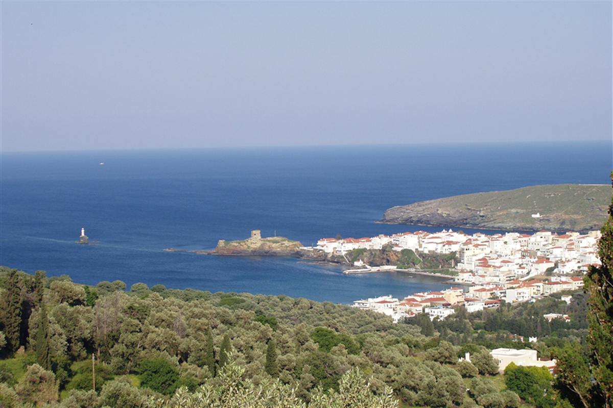
An Andros tour is a trip around Andros, the northernmost of the Cyclades, with its captains’ town of Chora, a Venetian castle on a rock, stone villages, springs and walking trails. The tour is one of the Greece Tours on Greece Ville, listed with the other Cyclades tours and Greek island tours.
This post covers Chora and its museums, the villages and ports, the rivers, trails and beaches, then the seasons, getting there and the formats on sale. Common questions come last.
What is an Andros tour?
An Andros tour covers an island of the Cyclades that is nearly 40 km long and 16 km across at its widest. An Andros tour links a capital town, port villages, ancient ruins and mountain valleys on a single route.
The island lies about 3 km north of Tinos, and its outline is long and narrow. Mountains fill the interior, and well-watered valleys run down between them toward the coast on both sides.
The coastline runs for 176 km and holds dozens of beaches. The municipality covers the main island together with a group of small uninhabited islets, so the land that an Andros tour crosses is only part of the administrative area.
The largest towns are Andros, Gavrio, Batsi and Ormos Korthiou. The sections below follow the main stops of the route, from the capital and its museums to the ancient city on the west coast.
The Cyclades tours post covers the wider archipelago that Andros belongs to, and an Andros tour sits inside that wider picture as one of its larger islands.
The word Andros names the island, the capital town and the municipality, so an Andros tour uses the name Chora for the town to keep the three apart.
- Length: The island is nearly 40 km from end to end.
- Breadth: The greatest breadth across the island is 16 km.
- Coast: The shoreline measures 176 km in total.
- Neighbour: Tinos lies about 3 km to the south.
In short, an Andros tour is a land-based survey of one large island, with museums, ruins and villages set along a long coast and a mountain interior.


What does an Andros tour show in Chora?
An Andros tour reaches Chora, the main town, where neoclassical mansions built after the First World War stand beside vernacular Cycladic houses and marble paves the squares. The Andros tour also finds four museums in the same town.
Chora is also called Andros town. The 2011 local government reform ended its status as a separate municipality, and the municipal unit now counts 3,918 inhabitants at the 2021 census.
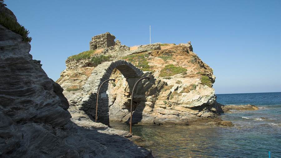
The town ends in a headland, and two islets lie at the tip. A brick bridge links the first islet to the mainland, and a ruined Venetian castle stands on it.
The second islet carries a lighthouse. The pair of islets gives the town its outline against the sea, and an Andros tour can read the Venetian past in the castle ruin from the bridge.
The four museums are the archaeological museum, the museum of modern art, the nautical museum and the folklore museum. The next two sections take the nautical and archaeological collections in turn.
The marble squares set the pace of a walk through the town, and the mixture of building styles shows two periods of construction standing side by side.
- Names: Andros and Chora both name the same town.
- Area: The municipal unit covers 102.756 square kilometres.
- Squares: The town squares are paved with marble.
- Museums: Four museums stand within the town.
Chora therefore works as the base of an Andros tour, since the mansions, the Venetian ruin and the museums all lie within one compact town.
What does an Andros tour learn at the maritime museum?
An Andros tour meets the island’s sea history at the Andros Maritime Museum, founded in 1972 to gather and preserve naval objects found on the island. The Andros tour reads that history through models, papers and everyday items.
The museum occupies an old building in the town. Dimitrios Rallias gave the building to the municipality of Andros, and the collection grew inside it.
The exhibits cover everyday life at sea. Visitors find lithographs, insurance policies, cutlery, uniforms and naval diaries, all tied to the work of seafarers from Andros.
The diaries describe the life of the island’s sailors before the War of Independence of 1821. They give a first-hand record of a trade that later made Andros a shipping centre.
The ship models range from old schooners to modern tankers. Together the models and papers present the history of the island’s merchant marine from antiquity to the present day.
The lithographs present scenes of everyday life, so the papers show the home side of seafaring as well as the ships that carried the cargo.
- Founded: The museum dates from 1972.
- Donor: Dimitrios Rallias gave the building to the municipality.
- Papers: Insurance policies and naval diaries record the working life of sailors.
- Models: The ship models run from schooners to tankers.
The maritime museum explains why an Andros tour pays so much attention to the sea, since the island’s wealth in the nineteenth century came from ships.
What does an Andros tour show at the archaeological museum?
An Andros tour includes the Archaeological Museum of Andros, established in 1981 after a donation from the Basil and Elisa Goulandris Foundation. The Andros tour finds a collection that runs from the Mycenaean era to the Roman period.
The architect Stamo Papadaki designed the building. It was made for the purpose, unlike the old house that holds the maritime museum, and it shows finds from the island’s long past.
The same Goulandris name ties the island to shipping and to art. Basil Goulandris lived from 1913 to 1994 and worked as a ship owner and arts patron.
His wider collection hangs elsewhere. The Goulandris Museum of Contemporary Art opened in October 2019 in Pangrati, Athens, and it shows works by Picasso, Chagall and Matisse that Basil Goulandris and his wife Elise collected.
Chora also lists a museum of modern art among its four museums. An Andros tour can therefore set ancient finds beside modern work within a short walk of the harbour.
The foundation’s name appears again at Palaiopoli, where it donated the building for the archaeological museum that opened there in 2003.
- Opened: The museum was established in 1981.
- Architect: Stamo Papadaki designed the building.
- Range: The collection spans the Mycenaean era to the Roman period.
- Patron: The Goulandris foundation funded the museum.
The museum gives the finds from across the island a single home, and an Andros tour uses it to connect Chora with the ruins on the west coast.
What does an Andros tour find at Gavrio?
An Andros tour finds Gavrio on the northwest side of the island, the first port of the Cyclades for ferries from the Attica coast. The Andros tour also meets a traditional village with ruins from the Hellenistic period.
Gavrio is a traditional village rather than a large town. Its ruins date from the Hellenistic period, when Andros held a place in the contest between two naval powers of the Aegean.
Macedon and Ptolemaic Egypt both wanted the island as a frontier post. In 333 BC a Macedonian garrison arrived from Antipater, and in 308 BC Ptolemy I of Egypt freed the island.
Control passed back to Macedon after a battle off the shore during the Chremonidean War, which ran from 266 to 263 BC. The Ptolemaic empire then kept a considerable fleet at Andros.
In 200 BC a combined Roman, Pergamene and Rhodian fleet captured the island. It stayed with the Attalid kingdom until 133 BC, when the kingdom ended and Rome received Andros.
The Ptolemaic empire stood at its height when this fleet sat at Andros, which explains the value of the island as a naval base in the third century BC.
- Position: Gavrio lies on the northwest side of Andros.
- Role: It is the first port of the Cyclades on this route.
- Ruins: The remains date from the Hellenistic period.
- Fleet: Ptolemaic ships were stationed at Andros in the third century BC.
Gavrio makes the natural first stop of an Andros tour, and its Hellenistic ruins recall how powers fought for a small island.
Which towns does an Andros tour link around Batsi?
An Andros tour treats Batsi as one of the four largest towns of the island, with Andros, Gavrio and Ormos Korthiou. The Andros tour crosses three municipal units that were separate municipalities until the Kallikratis reform of 2011 merged them.
The Kallikratis reform of 2011 created the current municipality of Andros. It merged three former municipalities, named Andros, Korthio and Ydrousa, into a single unit for the whole island.
The municipal unit of Andros is the largest of the three, with 3,901 inhabitants. Ydrousa follows with 3,372, and Korthio has 1,948.
These figures show that the population spreads across the island rather than gathering in the capital. Batsi, Gavrio and Ormos Korthiou each serve a stretch of coast with its own villages.
An Andros tour that links Batsi with the capital and the port therefore crosses all three units. The island is compact enough that the three pieces join in a single day of travel.
The municipality also includes the small uninhabited islands off the coast, so its map extends beyond the shoreline that an Andros tour follows by road.
- Andros: The municipal unit has 3,901 inhabitants.
- Ydrousa: The municipal unit has 3,372 inhabitants.
- Korthio: The municipal unit has 1,948 inhabitants.
- Merger: The 2011 reform joined the three municipalities.
Batsi, Gavrio and Ormos Korthiou are the anchors for the island’s coast, and an Andros tour uses them to cross from one municipal unit to the next.
What is Palaiopoli on an Andros tour?
The Andros tour reaches Palaiopoli, an ancient city on the west coast that served as the capital of Andros in the Classical period. The Andros tour follows fortifications that stay visible along the whole length of the ancient city.
The site lies 5 km from Ipsili and 10 km from Zagora. Pottery from the area dates back to the Mycenaean period, and parts of the area show signs of life in the Geometric period.
The finds include the Kore of Copenhagen, a kouros and a statue group of Pegasus and Bellerophon, all from the sixth century BC. They show that the city was prosperous in the Archaic period.
Building in the Classical city began at the start of the fifth century BC and continued into early Christian times. The city had a marketplace, a theatre, altars and temples, and it was well fortified.
The ancient harbour lay to the east, near the agora. The remains of the port lie under the sea today, and the breakwater of the harbour can still be seen underwater.
The British antiquary Theodore Bent surveyed the site briefly in early 1884, and his visit adds a modern chapter to the long record of the place.
- Temple: The city had a famous temple dedicated to Dionysus.
- Churches: Pre-Byzantine basilica churches show that life continued into the sixth century AD.
- Museum: The Archaeological Museum of Palaiopolis opened in 2003.
- Displays: Its three units cover sculpture, inscriptions and miscellaneous finds.
The museum holds a Pegasus sculpture, a funerary lion of the fourth century BC and a marble slab with a hymn to Isis, so the Andros tour has real objects to study.
What does an Andros tour see at Zagora and Strofilas?
An Andros tour passes Zagora, a settlement of the later Geometric period dated to the tenth to eighth centuries BC. The Andros tour also meets Strofilas, a fortified village of the Final Neolithic on the same stretch of the west coast.
A wall about 110 metres long closed off Zagora. The village lies about 1 km southeast of Strofilas along the coastline, so the two sites form a single walk through different eras.
Strofilas takes its name from the plateau where it was built. Its date falls between about 4500 and 4000 BC, at the start of the Cycladic culture of the Bronze Age.
The settlement stretched over 30 acres and was densely built. Archaeologists began excavations in 1997 under a team led by Christina Televantou.
The fortifications had a gate and bastions, and they are among the earliest examples of fortification in Greece. Rock carvings on the walls show jackals, goats, deer, fish, dolphins and a flotilla of ships.
Strofilas served as an important maritime centre, and the ships on its rock carvings fit that role. Zagora belongs to a much later age than the older village.
- Zagora: The wall around it was about 110 metres long.
- Strofilas: The village covered 30 acres on a plateau.
- Carvings: The rock art includes dolphins and ships.
- Excavation: Digging began in 1997.
The two sites show that people fortified this coast thousands of years before the Classical city, and an Andros tour reads that long history along a single shore.
Who was Theophilos Kairis on an Andros tour?
An Andros tour meets Theophilos Kairis, a priest, philosopher and revolutionary born on Andros in 1784. The Andros tour recalls him at the cliffside church of St George on the island, where he declared the War of Independence in 1821.
Kairis raised the Greek flag at the church and issued a speech that called on shipowners and merchants. He asked them to give funds and ships for a Greek navy against the Ottoman Empire.
In 1826 he began an institute for orphans of the revolution on Andros. Its subjects included astronomy, ship navigation, agriculture and accounting, and its pupils came from Bulgaria, Muslim families displaced by the war and Catholic families of the island.
Kairis also took an interest in archaeology and made major finds on his native island. He catalogued the plants of the local area as well.
The Kairis Library stands in a neoclassical building in Chora. It holds about 3,000 volumes from his collection, with rare publications, manuscripts, historical records, works of art and a small archaeological collection.
Kairis lived from 19 October 1784 to 13 January 1853. He spoke Ancient Greek, Latin, Italian, French, German and English, and he studied in Pisa and Paris.
- Born: Kairis was born on Andros in 1784.
- Church: The flag was raised at St George, a cliffside church.
- School: The orphan institute began in 1826.
- Library: The library in Chora keeps about 3,000 volumes.
Kairis was convicted by the Holy Synod in 1839 and died in 1853, so an Andros tour that follows his life ends on a sober note.
How did Byzantine rule shape an Andros tour?
The Andros tour covers a Byzantine period in which the island stayed relatively obscure, though it flourished in the Komnenian era through silk production. The Andros tour thus follows a quiet chapter between the ancient city and the Latin lords.
Andros was first part of the Province of the Islands. It later became part of the Theme of the Aegean Sea, one of the administrative regions of the empire.
Like other Aegean islands, it suffered raids by Saracens. The pre-Byzantine basilica churches at Palaiopoli show that settled life had already continued for centuries before those raids began.
During the Komnenian period the island flourished because of its silk production. It exported gossamer and velvet fabrics to Western Europe, which tied a small Aegean island to distant markets.
The silk trade shows that Andros was not a remote place in the Middle Ages. Its fabrics reached western buyers, and the wealth of that trade prepared the ground for the later shipping centre.
The empire left the island in relative obscurity, but the raids and the silk trade together show that it stayed within reach of the wider Aegean world.
- Province: Andros was first part of the Province of the Islands.
- Theme: It later joined the Theme of the Aegean Sea.
- Raids: Saracen raiders attacked the island.
- Silk: Gossamer and velvet fabrics went to Western Europe.
The Byzantine centuries leave fewer monuments than other periods, and an Andros tour uses this quiet stretch to link the ancient ruins with the later island story.
How did classical wars touch an Andros tour?
An Andros tour recalls an island with an Ionian population that sided with Persia in 480 BC and later resisted Athens in the Delian League. The Andros tour thus reads the Classical period through a sequence of sieges and garrisons.
In 480 BC the island supplied ships to Xerxes. The Greek fleet then harried it, and Andros joined the Delian League, though it stayed disaffected toward Athens.
In 477 BC Athens forced the island to obey by setting up a cleruchy there. The Andrians proclaimed their freedom again in 411 BC and withstood an Athenian attack in 408 BC.
Under the second Delian League the island again fell under a garrison and an archon. The record shows an island that kept pushing against the larger powers around it.
The famous temple of Dionysus at Palaiopoli belonged to this world. It stood in the capital of an island that traded, fought and changed sides as the powers of the Aegean shifted.
In ancient times the island held an Ionian population. Its position among the Cyclades made it a prize for each power that wanted to command the central Aegean.
- 480 BC: Andros supplied ships to Xerxes.
- 477 BC: Athens placed a cleruchy on the island.
- 411 BC: The islanders proclaimed their freedom.
- 408 BC: They withstood an Athenian attack.
The wars explain why fortifications matter so much at Palaiopoli, and an Andros tour reads the walls as evidence of a hard-fought independence.
What does an Andros tour show of the island as a whole?
The Andros tour ends with the island as a whole, a separate regional unit of the South Aegean region and the only municipality within it. The Andros tour finds a population that fell sharply between 1900 and 1991.
The regional unit was created out of part of the former Cyclades Prefecture in the 2011 reform. The older province of Andros, with the same territory, was abolished in 2006.
In 1900 the capital had about 2,000 inhabitants and the island about 18,000. By 1991 the island count had dropped to 8,781, and in 2011 the town numbered 1,665 and the island 9,221.
The north of the island holds a small Arvanite community, and the island’s name in Arvanitika is Ëndra. This layer of settlement dates to the Middle Ages, when Albanians crossed from Euboea.
A rock off the beach called Pidima tis grias, meaning the old woman’s leap, carries a story. Tradition holds that a woman jumped from a cliff and turned into the stone pillar.
Notable people from the island include Amphis, a comic poet of the fourth century BC, and Nikitas Kaklamanis, born in 1946, a doctor and politician who became mayor of Athens.
- Region: Andros is a separate regional unit of the South Aegean.
- Census: The island counted 9,221 inhabitants in 2011.
- Language: Arvanitika survives in the north.
- Legend: A coastal rock carries the old woman’s leap story.
The Greek island groups post covers how Greece sorts its islands into groups, and an Andros tour shows what one island in the Cyclades group holds.
How does the Andros Route path network shape an Andros tour?
An Andros tour can follow a network of marked hiking paths across the island, and the best known of them is the Andros Route, a trail of 100 km. The island itself is nearly 40 km long, so the paths wind across it.
Andros is the northernmost island of the Cyclades. It lies about 10 km southeast of Euboea and about 3 km north of Tinos, and an Andros tour on foot begins from that position.
At its greatest breadth the island measures 16 km, and from end to end it runs nearly 40 km. It is mountainous, with fruitful and well-watered valleys, and the paths of an Andros tour link those valleys with the coast.
The Andros Route is a marked trail of 100 km inside a wider network of marked hiking paths. The network gives walkers short sections and long sections across the whole island.
Older routes shaped the network. A kalderimi is a cobblestone road built for hoofed traffic, and in Greece these roads once linked almost every village, hamlet, chapel and sheepfold.
In rural Greece, the kalderimia remained the main way to get around until the 1960s or 1970s. Initiatives now map and restore them for walking tourism, so old and new routes meet.
- Trail: The Andros Route is a marked path of 100 km.
- Network: Marked hiking paths form a network across the island.
- Steps: Kalderimia use stones laid vertically as steps where the slope needs them.
- Walls: On slopes, kalderimia have retaining walls, and on steep ascents they use switchbacks.
The Greece hiking tours post covers walking routes elsewhere in the country. It places the Andros Route within the wider hiking map of Greece.
Where does Ormos Korthiou fit into an Andros tour?
An Andros tour reaches Ormos Korthiou, one of the four largest towns of the island alongside Andros, Gavrio and Batsi. The town gives its name to the Korthio municipal unit, one of three units that form the island’s single municipality.
Ormos Korthiou is named among the largest towns of Andros. The other three are the capital, Andros town, and the towns of Gavrio and Batsi on the western and northern side.
Korthio was one of three municipalities on the island. In the 2011 Kallikratis reform, Andros, Korthio and Ydrousa were merged into the single present municipality, so an Andros tour crosses one authority.
Census figures from 2011 give the Korthio unit 1,948 inhabitants. The Andros unit had 3,901 and the Ydrousa unit had 3,372, which makes Korthio the smallest of the three.
The whole municipality covers 380 km2. It includes the main island and small uninhabited islands, and it is the only municipality in the regional unit of Andros, within the South Aegean region.
Before 2006, the province of Andros belonged to the Cyclades Prefecture and matched the area of the present regional unit. An Andros tour therefore follows borders that changed in modern times.
- Towns: Andros, Gavrio, Batsi and Ormos Korthiou are the largest towns.
- Units: The municipality has three units named Andros, Korthio and Ydrousa.
- Korthio: The Korthio unit had 1,948 inhabitants in 2011.
- Area: The municipality covers 380 km2, including small uninhabited islands.
Ormos Korthiou and its unit show how the island is organised today. An Andros tour passes from one unit to another without leaving the single municipality that governs the whole island.
How do monasteries and chapels appear on an Andros tour?
An Andros tour passes churches and monastic houses along its paths, and the word monastery itself comes from Greek. The term derives from a verb meaning to live alone, because early Christian monks were all hermits who lived apart.
A monastery is a building or group of buildings for monks or nuns who live together or alone. It includes a place reserved for prayer, which can be a chapel, church or temple.
The Greek word monasterion comes from monazein, meaning to live alone, and its suffix marks a place for doing something. The earliest known use is by the Jewish philosopher Philo in the 1st century AD.
Larger complexes added dormitories, a refectory, a library and an infirmary. Barns, forges and workshops supported self-sufficiency, so a monastery was a working estate as well as a house of prayer.
On the tenth day of the fifth month of 1821, Theophilos Kairis raised the Greek flag at the Church of St George on Andros. That act brought the island into the Greek War of Independence.
At the end of the war, the island became part of the independent Kingdom of Greece. A church met on an Andros tour can therefore mark civic history as well as worship.
- Origin: Monazein means to live alone.
- Hermits: Early Christian monks were all hermits.
- Parts: A large complex held a church, dormitory, library and infirmary.
- Estate: Outlying granges and workshops supported self-sufficiency.
Monastic houses and village churches give the landscape its fixed points. An Andros tour uses them as waypoints between valleys, and each building carries its own part of the island’s story.
What is the Sariza spring at Apoikia on an Andros tour?
An Andros tour can pause at Apoikia, a village known for the notable spring of Sariza. The water flows from a sculpted stone lion’s head, which turns a natural source of groundwater into a crafted landmark of the island.
Apoikia is a village of Andros, and Sariza is its notable spring. The water leaves the rock through a lion’s head carved in stone, a form that gives the fountain a fixed shape.
A spring is a point where groundwater leaves an aquifer and flows across the ground as surface water. Springs have long supplied fresh water to people, especially in regions with little rainfall.
Natural forces such as gravity and hydrostatic pressure push water to the surface. A contact spring appears on a hillside where groundwater sits above an impermeable layer of rock or soil.
Karst springs form where groundwater travels through a network of cracks and fissures in limestone before it emerges. Groundwater also dissolves permeable rock such as limestone and dolomite, which creates large cave systems.
The yield of a spring varies widely, from almost nothing to more than 14,000 litres per second at the biggest ones. An Andros tour crosses ground with plenty of water.
- Village: Apoikia holds the spring of Sariza.
- Outlet: The water flows from a sculpted stone lion’s head.
- Source: A spring is groundwater that emerges from an aquifer.
- Karst: Karst springs emerge from networks of cracks and fissures.
The lion’s head at Sariza turns a natural spring into a crafted landmark. An Andros tour includes the village stop for that reason, and the water keeps the link between valley and village visible.
Who settled the northern villages on an Andros tour?
An Andros tour crosses the north of the island, where a small Arvanite community lives. Albanians crossed from Euboea in 1416 and settled the northern part, at about the same time that Ottoman raiders carried off almost the entire population.
Euboea lies about 10 km from Andros across the water, and Tinos lies about 3 km to the south. An Andros tour in the north follows a coast that faces that neighbouring island.
Arvanites are a community of Greece with their own language, Arvanitika. On Andros, the north has a small Arvanite community, and the island has its own name in Arvanitika.
In 1416, the Ottomans raided the island and carried off almost the entire population. Albanians arrived at about the same time, so the settlement of the north dates to that period.
Settlers brought their speech with them, and language carries the record. A walker on an Andros tour reads the settlement story from the community that remains in the north.
The northern part was not left empty after the raid. Albanians who arrived from Euboea settled there in the same period, and their descendants form the small Arvanite community of the present day.
- Date: Albanians settled the north in 1416.
- Origin: They crossed from Euboea.
- Community: A small Arvanite community lives in the north.
- Language: The island’s name in Arvanitika differs from the Greek name.
The northern settlement is a record of movement across the narrow sea. An Andros tour in the north reads that record through the community that survives there today.
How did population change reshape the paths of an Andros tour?
An Andros tour crosses an island whose population fell sharply during the twentieth century. About 18,000 people lived on Andros in 1900, and by 1991 the number had dropped to 8,781, which left the old rural paths with far fewer users.
The capital had about 2,000 inhabitants in 1900. By 2011 the town counted 1,665 residents, while the island as a whole numbered 9,221, a figure above the level of 1991.
The fall left terraces, paths and chapels with fewer people to use them. A walker on an Andros tour therefore passes ground that supported a far larger rural population.
The old kalderimi network mainly ran up and down mountainsides to villagers’ fields. Modern roads instead connect adjacent villages at the same altitude, so travel moved from a vertical axis to a horizontal one.
A study of villages on the Methana peninsula found the same effect: new roads divorced travel from proximity to a villager’s land. An Andros tour on old paths restores that closeness.
The 2011 count of 9,221 is about half the figure from 1900. An Andros tour therefore crosses villages and valleys that once held double the present number of people.
- 1900: About 18,000 people lived on the island.
- 1991: The population had dropped to 8,781.
- 2011: The island counted 9,221 inhabitants.
- Town: Andros town had 1,665 inhabitants in 2011.
Population figures explain why old paths cross empty ground. The routes were built for a larger rural community and are now open to walkers who follow them.
What do dovecotes add to an Andros tour?
An Andros tour can pass a dovecote, a structure built to house pigeons or doves. In Greece such towers are called peristeriones, and they are popular across the Cycladic islands, where the Venetians introduced systematic breeding in the 15th century.
A dovecote can stand alone in a variety of shapes or be built into the end of a house or barn. It holds pigeonholes where the birds nest.
Historically, pigeons and doves were an important food source in the Middle East and Europe. People kept them for their eggs and dung as well as for meat.
In the Cyclades, the Venetians introduced systematic breeding of doves and pigeons as sources of meat and fertilizer. That introduction took place in the 15th century, and an Andros tour sits in the same island group.
Builders set dovecotes on slopes protected from the prevailing north wind. They oriented each facade towards an open space, a rule that an Andros tour can test by looking at the towers it passes.
The wild ancestor of the farm bird is the rock dove, which roosts and breeds on cliffs and rock ledges. Droppings gave farmers fertilizer, and they also served in leather tanning and gunpowder.
- Greek name: Peristeriones is the Greek plural for dovecotes.
- Oldest: The oldest dovecotes are thought to lie in Upper Egypt and Iran.
- Status: In medieval Europe, owning a dovecote was a symbol of status and power.
- Fertilizer: Pigeon droppings served farmers as fertilizer.
A dovecote shows how farmers in the Cyclades used birds for food and manure. An Andros tour reads the structure as farm equipment as much as a landmark.
Why do dry-stone walls matter on an Andros tour?
An Andros tour passes dry-stone walls, which are built from stones without mortar. Carefully selected interlocking stones give the binding, and UNESCO inscribed the art of dry stone walling on its intangible heritage list in 2018, with Greece among the countries named.
Builders use the method for field boundaries and churchyards, and for retaining walls that hold terraces. Dry stone shelters and houses exist too, but walls are the best-known form.
The technique appears throughout the Mediterranean, including retaining walls for terracing. Such walls suit places where large stones are plentiful or where conditions are too harsh for hedges, which an Andros tour shows on its slopes.
Thousands of kilometres of dry-stone walls exist across Europe, and the bulk of them are centuries old. A walker on terraced slopes sees one short stretch of that long record.
One account says hunters built the first stone walls to trap or ambush wild game. Farmers later piled loose fieldstones into dry stone walls, which is the origin of the field wall.
Wall building on Andros is old. On the west coast, Strofilas was a Final Neolithic settlement, dated around 4500 to 4000 BC, whose fortifications had a gate and bastions.
- Method: Stones lock together without mortar.
- Uses: Walls mark fields, churchyards and terraces.
- Heritage: UNESCO listed the art of dry stone walling in 2018.
- Region: Dry-stone walls occur throughout the Mediterranean.
Each wall records a builder’s choice of stone and slope. An Andros tour reads the terraces as a working system, in which the wall and the soil it holds belong together.
Where do waterfalls and streams belong on an Andros tour?
An Andros tour crosses a mountainous island with fruitful, well-watered valleys, so water shapes the route. A waterfall is any point in a river or stream where water flows over a vertical drop or a series of steep drops.
Andros is mountainous, with fruitful and well-watered valleys. Streams cut those valleys, and any fall found on an Andros tour follows the same rules that govern every waterfall in the world.
The common way a waterfall forms is a river crossing a resistant top layer of bedrock before dropping onto softer rock. The softer rock erodes faster, so the fall grows higher.
Waterfalls recede upstream. The rate of retreat can reach one-and-a-half metres per year, and over time the fall carves a canyon or gorge downstream as it moves back.
A cascade is a smaller waterfall, and a cataract is a larger and more powerful one. Sources apply the words loosely, so the label matters less than the drop itself.
Since the 18th century, waterfalls have drawn increased attention as tourist destinations. Humans have travelled to see, name and explore them since prehistory, and an Andros tour continues that habit.
- Definition: A waterfall is a vertical or steeply stepped drop in a river.
- Formation: Resistant bedrock over softer rock forms the common fall.
- Retreat: A fall can move upstream by up to one-and-a-half metres a year.
- Shelter: Undercutting can form a shallow rock shelter behind the water.
Streams and falls explain why the valleys of Andros stay green. An Andros tour follows the water upstream to see where rock layers give it a drop.
Which plants cover the hillsides on an Andros tour?
An Andros tour crosses Mediterranean shrubland of two main kinds, maquis and garrigue. Maquis is a savanna-like shrubland of densely growing evergreen shrubs, and garrigue is a lower scrubland of aromatic plants that grows on limestone soil.
Maquis shrubs top out at around 4 to 5 metres. Winters are humid and temperate, summers are dry, and the soil is highly acidic, which suits an Andros tour in the cooler seasons.
Common maquis plants include laurel, myrtle, olive, carob, fig and holm oak. The plants of this biome are xerophilous, and a number of them go dormant in the dry summer.
Garrigue grows on limestone and other base-rich soils near the sea. Juniper and stunted holly oaks stand in it, and aromatic shrubs such as sage, rosemary and Artemisia fill the open spaces.
The grey-green look of garrigue comes from white hairs and pebbled leaf surfaces, which scatter light under clear summer skies. Aromatic oils from leaf litter also hold back neighbouring annual plants.
Garrigue is a degraded form of evergreen oak forest that stood until around 2500 BCE. Origanum, the genus of oregano and marjoram, brings strongly aromatic leaves to such ground.
- Maquis: Dense evergreen shrubs reach 4 to 5 metres.
- Garrigue: Widely spaced bushes stand among open spaces.
- Aromatics: Sage, rosemary, lavender and wild thyme scent the scrub.
- Origanum: The genus has about 67 species, including oregano and marjoram.
The plant cover explains the scent of the paths in the warm months. An Andros tour passes from olive and carob terraces to open scrub as the ground rises.
Which birds can an Andros tour show?
An Andros tour can show cliff and scrub birds of the Aegean, from falcons to partridges. Eleonora’s falcon, the chukar and the alpine swift each have features that make them recognisable, from a colour morph to a song.
Eleonora’s falcon commemorates Eleanor of Arborea, a national heroine of Sardinia, who in 1392 became the first ruler in history to protect hawk and falcon nests from illegal hunters.
The falcon has two colour morphs. The dark adult is all sooty brown with black underwing coverts, while the light morph has buff underparts. Its call is a falcon’s kek-kek-kek.
The chukar is a rotund partridge, 32 to 35 cm long, with a light brown back and a grey breast. A black band from the forehead through the eye forms a necklace around a white throat.
Its name imitates its song, a noisy chuck-chuck-chukar. The legs are red and the bill is coral red, so an Andros tour that finds one can identify it quickly.
Very short legs let the alpine swift cling to vertical surfaces, and the bird never settles voluntarily on the ground. The crag martin builds neat mud nests under cliff overhangs.
- Falcon: Eleonora’s falcon has two colour morphs.
- Partridge: The song of the chukar gives it its name.
- Swift: The alpine swift lives in the air and catches insects in its beak.
- Martin: Crag martins nest in mud cups under cliff overhangs.
Birds add movement to the stone and scrub of the island. An Andros tour with a pair of binoculars turns a walk along the cliffs into a count of species.
Which beaches does an Andros tour reach?
An Andros tour follows a coastline of 176 km that carries dozens of beaches, so the sea frames almost every route across the island. Bays, rocky headlands and small islands all belong to that long and varied shore.
A published figure puts the coastline of Andros at 176 km. That distance gives the island room for dozens of separate beaches, and an Andros tour can turn toward the water on almost any day.
One beach carries the name Pidima tis grias, which translates as the old woman’s leap. A vertical rock stands close to the shore there, and tradition holds that a woman jumped from a cliff.
The same story says that she was transformed into the stone pillar. Such tales give the shoreline a local voice, and an Andros tour can use them to explain the shape of a rock.
The municipality covers more than the main island. It also includes small uninhabited islands, so the sea around Andros holds islets as well as beaches, and each headland frames a different view.
A fortified village of the Final Neolithic, called Strofilas, stood on the west coast. Its rock carvings include fish, dolphins and a flotilla of ships, so the sea shaped life on this shore from the start.
- Coastline: The shore of Andros runs for 176 km.
- Beaches: The coast holds dozens of them.
- Old woman’s leap: The Pidima tis grias rock rises vertically near the shore.
- Islets: The municipality includes small uninhabited islands beside Andros itself.
Beaches therefore form a steady thread through an Andros tour, joining the mountain villages of the interior with the water that surrounds the island on every side.
What do boat trips add to an Andros tour?
An Andros tour by boat uses a narrow strait, because Tinos lies about 3 km to the south, and the same sea links the island with Delos and Mykonos. Short crossings make the neighbouring islands part of one wider route.
Andros lies about 3 km north of Tinos, and the strait between them is short. A boat on an Andros tour therefore moves from one Cyclades island to the next within sight of both coasts.
The closest islands to Tinos are Andros, Delos and Mykonos. That list shows how tightly the northern Cyclades sit together, and it explains why boat routes in this part of the sea are so connected.
Tinos has three ports. One serves passenger speed boats, and the other two serve ferries and high-speed boats, which carry cars as well as passengers, so the strait carries vehicle traffic too.
Meltemi winds on Tinos come up in clear weather without warning. They are dangerous to sailors, because the Beaufort scale rates their gusts at force 7 to 8, and skippers read the sky early.
The winds are strongest in the afternoon and die down at night, although sometimes they last for days without a break. A boat plan on an Andros tour bends around that rhythm.
- Strait: About 3 km separates Andros from Tinos.
- Neighbours: Delos and Mykonos are among the closest islands to Tinos.
- Warning: Meltemi winds rise in clear weather without a sign.
- Rhythm: The wind is strongest in the afternoon and eases at night.
The Greece boat tours post covers boat trips across the whole country, and it places the sea around this island within that wider picture.
What food belongs on an Andros tour?
An Andros tour sits within Kykladitiki, the regional Greek cuisine of the Cyclades, which draws on olive oil and wheat, the basic staples of Greek cooking. Island kitchens across the archipelago add Byzantine and Ottoman traditions to that base.
Greek cooking is sorted into regional cuisines, and the Aegean islands form one group. Within it, Kykladitiki is the name for the food of the Cyclades, the archipelago that holds Andros.
Olive oil is the defining and ancient element of Greek cuisine. Cooks add it to nearly every dish, and the olives themselves are eaten widely, so an Andros tour meets them at the table.
Wheat is the basic grain of Greece, and barley is grown as well. Those two grains stand behind the bread and pastry that an Andros tour sets beside the main dishes.
Other dishes carry a long history. Avgotaraho, a cured fish roe, entered Greek cooking from Byzantium, while sweets such as kadaifi and halva came from Ottoman cuisine, and both appear on island menus.
Italian cuisine also left a mark. Salami, macaronia and mandolato entered Greek cooking from Italy with modifications, a link that fits an island once ruled under Venetian feudal law.
- Regional name: Kykladitiki is the cuisine of the Cyclades.
- Oil: Olive oil is the oldest and defining element of Greek cooking.
- Grain: Wheat is the basic grain, with barley grown beside it.
- Roots: Avgotaraho is Byzantine, while kadaifi and halva are Ottoman.
Food on an Andros tour therefore reads as part of wider Greek cooking, with island produce, Byzantine roots and Ottoman sweets set side by side on one table.
How do ferries from the mainland reach an Andros tour?
An Andros tour starts on the Attica coast, where Rafina serves ferries to southern Euboea and the Cyclades, and acts as the second port of Athens after Piraeus. The island side of the crossing is Gavrio, on the north-west coast of Andros.
Rafina is a suburban port town on the eastern coast of Attica. It lies 25 km east of the centre of Athens and belongs to the Athens metropolitan area.
The town had 14,620 inhabitants at the 2021 census. It lies east of Mount Pentelicus, and the land around it is mainly woodland and farmland, so the port sits at the edge of the city.
On the island side, Gavrio on the north-west coast is the first port that the Cyclades offer to travellers from Attica. An Andros tour from the mainland therefore begins with an arrival at that harbour.
Ferries allow direct transit between points at a capital cost much lower than bridges or tunnels. That logic explains why a chain of islands such as the Cyclades depends on regular ferry service.
Rafina is twinned with Pano Lefkara in Cyprus, Tirilye in Turkey and Triglia in Chalkidiki, which shows that the port has ties beyond Attica as well as the island links.
- Attica port: Rafina sits on the eastern coast of Attica.
- Distance: The port lies 25 km east of central Athens.
- Rank: Rafina is the second port of Athens after Piraeus.
- Island port: Gavrio lies on the north-west side of Andros.
A ferry crossing thus links the mainland and an Andros tour without a bridge, and the departure point lies close to Athens.
Why does Tinos matter next to an Andros tour?
The Andros tour has Tinos next door, because the two islands lie about 3 km apart and Tinos counts Andros among its closest neighbours, with Delos and Mykonos. The two islands share a Venetian past and a Cycladic landscape.
Tinos belongs to the Cyclades, and its history runs close to that of Andros. After the Fourth Crusade, private Venetian citizens ruled it, and the Ghisi family held it until 1390.
In 1390 the last member of that family branch bequeathed Tinos and Mykonos to Venice. Venice ruled Tinos until 1715, when the Ottoman Empire captured it, and the Ottomans held it until 1821.
The ancient name of the island was Tenos. It was also called Hydroussa from the number of its springs and Ophioussa because it abounded in snakes, so its names describe water and wildlife.
The island is known for its sculptors and painters, among them Nikolaos Gysis, Yannoulis Chalepas and Nikiforos Lytras. An Andros tour that crosses the strait meets a place with a strong artistic record.
Both Tinos and Andros became separate regional units of the South Aegean in the 2011 Kallikratis reform, and each is a single municipality, which keeps the two islands side by side on the map.
- Boulders: The landscape around Volax holds giant boulders.
- Marble: The mountains around Pyrgos contain green marble.
- Stone: Islanders built terraces and stone walkways across the hills.
- Granite: A granite mine lies near Volax.
The Syros day trip post covers the neighbouring island of Syros and its towns, which complete the northern Cyclades picture around an Andros tour.
What Venetian and Ottoman history does an Andros tour cover?
An Andros tour crosses Venetian and Ottoman history, because the island joined the Duchy of the Archipelago in 1207, fell under Ottoman control in 1566 and received a charter of local privileges in 1580. Each period left records.
Under Byzantine rule Andros was relatively obscure, yet in the Komnenian period it flourished through silk production, exporting gossamer and velvet fabrics to Western Europe before the Venetian era began.
In 1207 Marco I Sanudo took Andros into the Duchy of the Archipelago and gave it as a sub-fief to Marino Dandolo. Venice had been slated to control the island after 1204.
A long inheritance case followed. Mediation by the Venetian bailo in 1291 to 1293 ended it, when a claimant renounced his rights for 5,000 pounds, and the Sanudo dukes styled themselves lords of Naxos and Andros.
Raids marked the later period. In 1416 the Ottomans carried off almost the entire population, and Albanians crossed from Euboea to settle in the north of the island.
In 1468 four ships attacked and the baron Giovanni Sommaripa was killed. Two years later another raid left the island with 2,000 inhabitants, yet Andros and Paros remained the wealthiest islands of the Cyclades.
- 1537: The Ottoman admiral Hayreddin Barbarossa seized the island, and tribute later brought it back.
- 1566: The Andrians rose against their ruler and the island came under Ottoman control.
- 1580: A charter gave the Cyclades local autonomy, low taxes and religious freedom.
- 1770s: Russian forces occupied Andros during the Russo-Turkish War.
The record shows an island that passed between powers and kept its own character, and an Andros tour reads that history across its villages and ruins.
How did the shipowners shape an Andros tour?
An Andros tour passes the homeland of Greek shipping, because the island became a major shipping centre after independence, and by 1914 Andrian-registered shipping ranked second in Greece by capacity. Ship-owning families left the island for Piraeus and London only later.
On the tenth day of the fifth month in 1821, the scholar Theophilos Kairis raised the Greek flag on Andros. His speech swayed shipowners and merchants to give funds and ships for a Greek navy.
After independence, Andros became a major centre of Greek shipping. It was helped by refugees from Psara and by the decline of older shipping centres such as Galaxeidi and Hydra.
Andrian merchants were active in the grain trade from central and eastern Europe, conducted from the Danube estuary. The ships were first built locally and later at Syros as steam arrived.
Registered ships rose from 25 in 1921 to 80 before the Second World War. Losses in that war, the internationalisation of shipping and the move of owning families to Piraeus and London ended the era.
In 1900 the island had about 18,000 inhabitants. The number had fallen to 8,781 by 1991, and the island counted 9,221 in 2011, a decline that runs alongside the departure of the shipping families.
- Origins: Greek ship-owner families trace their origin to Andros, Chios or Cephalonia.
- Rank: Andrian shipping stood second in Greece by capacity in 1914.
- Builders: Syros yards built the later Andrian ships.
- Modern name: Adamantios Polemis is listed among the major shipowners from the island.
The shipping story explains the wealth that once flowed through the island, and an Andros tour follows that story from the harbours to the villages.
Which months suit an Andros tour?
An Andros tour suits a climate that the national weather service classes as hot semi-arid for the larger part of the Cyclades, with a Mediterranean pattern on other islands. The east of the Pindus range is drier and windier in summer.
The Climate Atlas of Greece, published by the Hellenic National Meteorological Service, places the Mediterranean climate on a group of the Cyclades. A hot semi-arid climate covers the larger part of the archipelago.
Schoinoussa, a small island of the Cyclades, is the driest area in Greece. That fact shows how dry the archipelago can be, and it frames the weather that an Andros tour meets.
The climate is wetter and has maritime features to the west of the Pindus mountain range. The east of the range is drier and windier in summer, so travellers on the Aegean side expect that pattern.
Annual average temperatures in Greece run from around 4 °C at Kaimaktsalan to 22 °C at Lindos. The Cyclades sit within that national range, so the choice of month shapes how an Andros tour feels.
- Classification: A hot semi-arid climate covers the larger part of the Cyclades.
- Further islands: A Mediterranean climate covers a group of the Cyclades.
- Driest point: Schoinoussa is the driest area in Greece.
- East side: The east of the Pindus range is drier and windier in summer.
The best time to visit Greek islands post covers the seasons across the whole island world, and it supports the choice of month for an Andros tour.
Which festivals and anniversaries shape an Andros tour?
An Andros tour meets festivals in two layers: the old Greek panegyris, a gathering with prayers, sacrifices and processions, and the church feasts of the Orthodox year. Late summer holds the main church dates, the Transfiguration and the Dormition fast.
A panegyris was an ancient Greek assembly, dedicated to the worship of a particular god. Prayers were made, sacrifices were offered and processions took place, and the name is tied to saint days and holy festivals.
The Feast of the Dormition falls on 15 August and is preceded by a fast from 1 to 14 August. That fast is stricter than the fasts of Advent and of the Apostles.
Within the fast, the Transfiguration on 6 August allows fish, wine and oil. The first day of the fast, 1 August, is the Procession of the Cross, with an outdoor procession and a blessing of water.
A civic anniversary also belongs to the island. Theophilos Kairis, born on Andros in 1784, raised the flag at the cliffside church of St George, and his library of about 3,000 volumes stands in Chora.
His orphan school took in children from Bulgaria, Muslim Turks displaced by the revolution and Catholics who had lived on the island since the Middle Ages, and it began in 1826.
- Panegyris: This ancient gathering joined prayer, sacrifice and procession.
- Dormition: The feast falls on 15 August after a fast.
- Transfiguration: Fish, wine and oil are allowed on 6 August.
- Kairis: His orphan school on Andros opened in 1826.
The calendar therefore adds a living layer to an Andros tour, joining church feasts with the memory of the revolution.
Which formats of Andros tour are on sale?
An Andros tour is on sale in a range of formats, from full-day village tours and trips from Athens to waterfall treks, off-road rides, boat cruises and day crossings to neighbouring islands. Each format picks a different side of the island.
The village format covers the villages and natural highlights of the island in one full day. A separate trip from Athens adds the waterfalls and carries travellers over to Andros and back.
A trekking format follows the Achla river toward the only waterfall in the Cyclades. A springs format visits Menites and a cave named Foros, and a monasteries format starts from Batsi.
An off-road format also starts from Batsi and heads for Vitali beach. A boat format uses a RIB cruise, and it runs either shared with other passengers or as a private charter.
Two exclusive day trips cross the sea from Andros, one to Syros and one to Mykonos, and each includes lunch. Those formats treat the island as a base for the wider group.
The formats differ in terrain. Village, springs and monastery formats follow roads, the trek follows a river, the off-road format leaves the tarmac, and the cruise and island crossings use the sea.
- Villages: A full-day tour reaches villages and natural highlights.
- Waterfalls: A trip from Athens and a river trek both reach water.
- Sea: A RIB cruise runs shared or private.
- Islands: Day trips cross to Syros and to Mykonos with lunch.
The tour cards and availability boxes on this page list live dates for every format of an Andros tour, so the current choices appear there.
What do travellers ask about Andros tour?
An Andros tour raises four recurring questions: how far Tinos lies, which port serves the mainland crossing, who Theophilos Kairis was and which regional cuisine belongs to the Cyclades. The answers below rest on the facts set out above.
How far is Tinos from an Andros tour?
An Andros tour sits about 3 km north of Tinos, which makes Tinos the nearest large neighbour. Delos and Mykonos also count among the closest islands to Tinos, so the northern Cyclades stand close together across short straits of sea. The distance stays short whichever side of the strait is used.
Which port serves an Andros tour from the mainland?
An Andros tour from Attica begins at Rafina, a port town on the eastern coast, 25 km east of central Athens. Rafina serves ferries to southern Euboea and the Cyclades, and Gavrio is the island port that receives travellers on the north-west coast.
Who was Theophilos Kairis on an Andros tour?
An Andros tour recalls Theophilos Kairis, a Greek Orthodox priest, philosopher and revolutionary who was born on the island in 1784. In 1821 he raised the Greek flag at St George’s church, and in 1826 he began an orphan school.
Which cuisine does an Andros tour taste?
An Andros tour tastes Kykladitiki, the regional cuisine of the Cyclades within the wider Greek tradition. Olive oil is its defining element, wheat is the basic grain, and Byzantine and Ottoman dishes add to the table alongside Italian borrowings. Kykladitiki sits among the Aegean island cuisines.
Featured photo: Vassilis Kyrtatas, public domain, via Wikimedia Commons.