
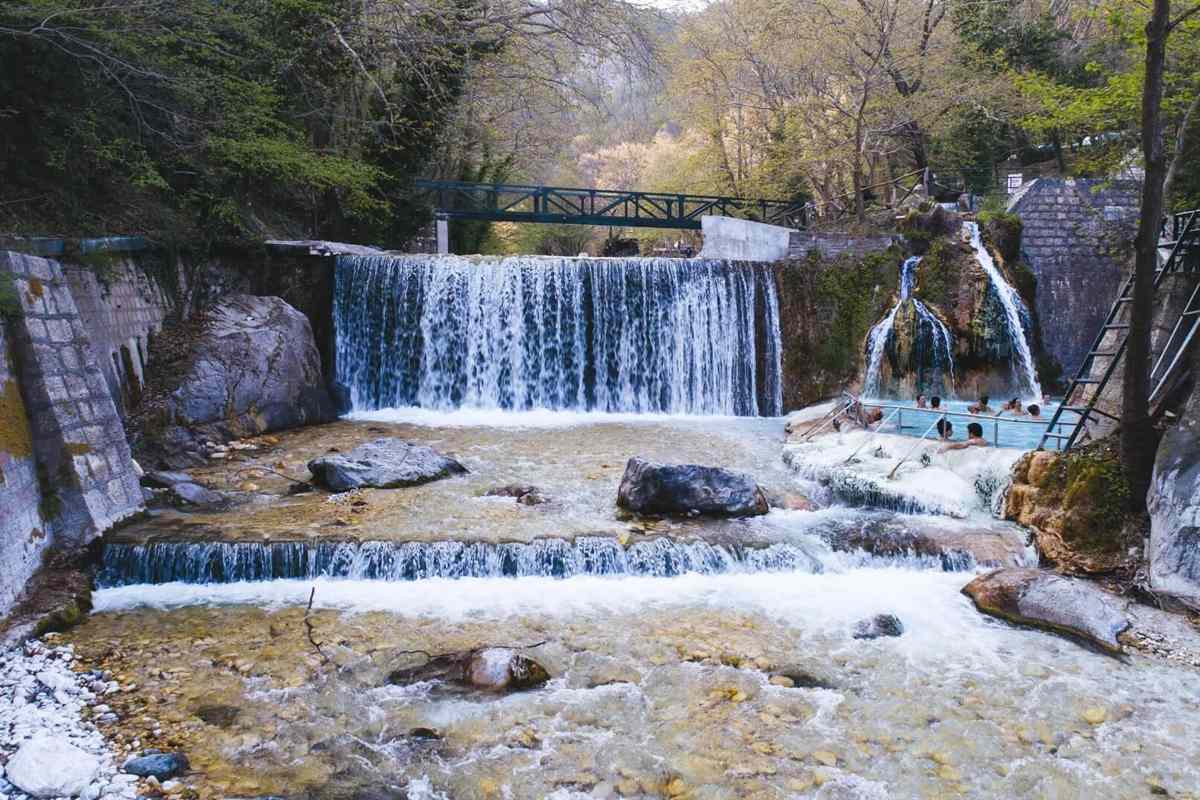
The Pozar thermal baths are warm springs and pools in a wooded gorge at Loutraki in the Almopia area of northern Greece, reached on day trips from Thessaloniki that add the waterfalls of Edessa. The trip is one of the Greece Tours on Greece Ville, listed with the other Northern Greece tours.
This post covers the formats on sale, the springs and the gorge, Almopia and Aridaia, Mount Kaimaktsalan and the ski area, the battle on the mountain, Edessa and its waterfalls, the Pella regional unit and the questions that come up before booking.
What are the Pozar thermal baths at Loutraki in northern Greece?
The Pozar thermal baths are natural hot springs at the village of Loutraki in the Almopia area of Pella, northern Greece. They lie 32 km north of Edessa and 13 km west of Aridaia, and visitors reach them on day trips.
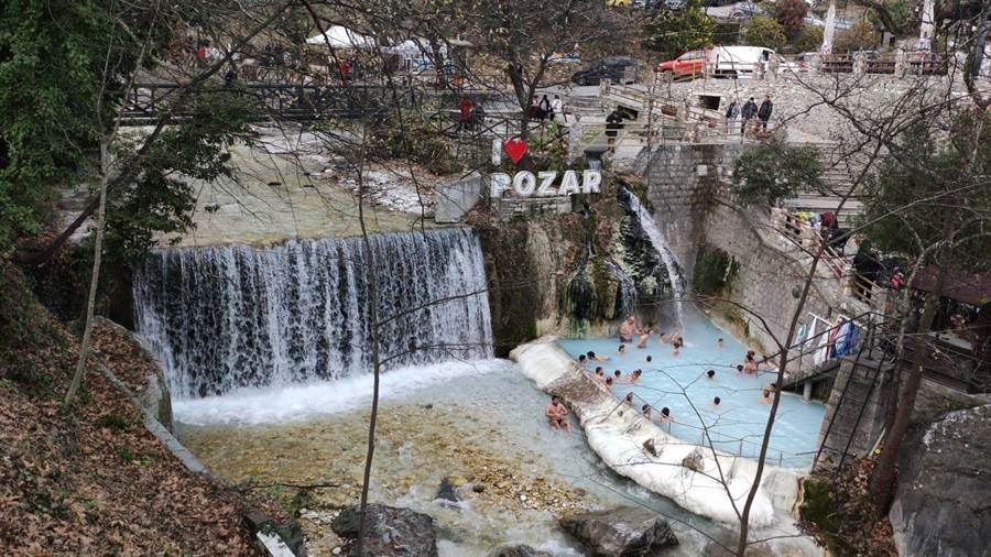
In Greek the site is Λουτρά Πόζαρ. The name Pozar also marks the main plain in the north of the Pella regional unit, and a second name for the springs is Loutra Loutrakiou.
The host village of Loutraki carried the name Káto Pózar before 1922 and Káto Loutrákion until 1959. It had 1066 inhabitants in 1981, and the community now counts 1,176 people.
Loutraki falls within the Aridaia municipal unit of Almopia in the Pella regional unit. After the town of Aridaia itself, Loutraki stands among the largest communities of that unit.
Beside the Pozar thermal baths, the village lists the Nature and Folklore Museum of Loutra Almopias among its places of interest. Next to Loutraki lies the tourist village of Orma.
The springs form a tourist destination with infrastructure and a full set of amenities. They pair with the Kaimaktsalan ski centre, which also lies geographically within the Municipality of Almopia.
- Region: The Pella regional unit forms part of the Region of Central Macedonia.
- Status: Loutraki is a tourist village and the seat of Loutra Pozar.
- Season: The springs are a popular tourist attraction in the cooler months.
- Province: Almopia was one of the three provinces of Pella Prefecture until its abolition in 2006.
The sections below cover the formats on sale, the springs and the river, the Almopia valley and the mountain above the Pozar thermal baths.



Which tour formats include the Pozar thermal baths?
The Pozar thermal baths appear on sale in day trips from Thessaloniki that pair the springs with Edessa, a springs trip with free time, a shared minivan tour, private tours and a private tour from Kastoria that adds a winery.
The core format runs from Thessaloniki. One listing reads ‘From Thessaloniki: Pozar Thermal Baths and Edessa Day Trip’, and another reads ‘Pozar Thermal Baths and Edessa Day Trip from Thessaloniki’. Both pair the springs with Edessa.
A second Thessaloniki option carries the title ‘Thessaloniki: Pozar Springs Trip with Free Time’. It centres on the springs and leaves free time on site, with no second stop named in the title.
A shared format runs under the title ‘Pozar Baths to Edessa Waterfalls Shared Tour by Minivan’. Travellers share the vehicle with other passengers, and the route links the baths with the Edessa Waterfalls.
Private formats include ‘Private Day Trip to Pozar Thermal Baths & Edessa Waterfalls’ and ‘Pozar Thermal Baths and Edessa Waterfalls Private Tour’. A private tour reserves the vehicle for one group alone.
The title ‘Kastoria: Private Pozar Thermal Baths, Edessa, & Winery Tour’ marks a private format that starts in Kastoria. It adds Edessa and a winery visit to the time at the springs.
- Start points: The listed titles name Thessaloniki and Kastoria as departure cities.
- By bus: The KTEL of Pella links Aridaia with Edessa and also runs routes to Thessaloniki.
- By rail: Aridaia has no railway station, so rail travellers use the stations of Edessa and Skydra.
- By road: Pella Provincial Road 7 runs from Aridaia through Loutraki to the springs.
Visitors staying in Thessaloniki can pair a day at the springs with a Thessaloniki food tour. The tour cards and availability boxes on this page list live dates for each format.
How do the springs and the warm river shape the Pozar thermal baths?
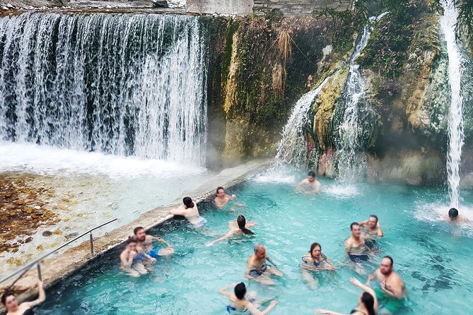
The Pozar thermal baths draw on hot springs in a mountainous area at an altitude of 360 to 390 m. Five springs gush along a warm river at the site, and that river flows on into the basin of Almopia.
Water at the Pozar thermal baths is naturally heated at 37 °C (99 °F). One hot spring definition uses human body temperature, normally about 37 °C, as its threshold.
Like any hot spring, each Loutraki source carries geothermally heated groundwater to the surface. That groundwater gains heat either from shallow magma or by circulating through faults to hot rock deep in the crust.
Heated water can hold more dissolved solids than cold water. As a result, the water that issues from a hot spring can carry a very high mineral content, ranging from calcium to lithium.
Humans have used hot springs for bathing and for relaxation for thousands of years. In the Homeric Age of Greece, around 1000 BCE, such baths served primarily for hygiene.
- Area: The hot spring zone occupies 30 hectares, or 75 acres.
- Warm spring: A 1923 proposal defined a warm spring as one below body temperature but above the mean air temperature.
- Thresholds: Other definitions set the hot spring line at 21 °C (70 °F) or at 50 °C (122 °F).
- Bathing custom: Bathers at hot springs commonly wash before entering the water so as not to contaminate it.
The river from the Pozar thermal baths runs down into Almopia, and the next section follows it to the valley and to the town of Aridaia.
What surrounds the Pozar thermal baths in Almopia and Aridaia?
The Pozar thermal baths lie in Almopia, a municipality of 985.817 km2 in the Pella regional unit. Its seat is Aridaia, a town in the northwest corner of the unit that borders North Macedonia and the Florina regional unit.
The name Almopia comes from the Almopes, a Paeonian tribe expelled from the area when it joined Lower Macedonia. The tribe traced its descent to Almops, a son of Poseidon and Helle.
In the later Middle Ages the area was Moglena, from the Slavic word for fog. The Byzantine emperor Basil II captured it in 1015, and it became the capital of its own theme in 1086.
Aridaia lies 13 km east of the Pozar thermal baths. The town proper has 7,118 residents, while its municipal unit counts 18,864 people across 17 communities.
The town was Soúmboskon until 9 June 1922 and Ardéa until 24 April 1951. One theory ties Ardéa to a Greek verb meaning ‘to irrigate’, after the rivers, streams and irrigation canals of the area.
- Castle of Chrysi: This Byzantine castle stands 7 km from Aridaia and dates back to the 8th century AD.
- Saint Hilarion: A monastery north of the town honours Saint Hilarion, a 12th-century bishop of Moglena.
- Black Valley: Under Ottoman rule the area also went by the Turkish name Karadjova, the ‘Black Valley’.
- Old railway: A line from Skydra to Aridaia and Orma ran from 1916 until it closed in 1936.
Travellers based in Kastoria can combine a Kastoria tour with the Pozar thermal baths, as one private format starts in that city and also covers Edessa.
Which mountain rises above the Pozar thermal baths?
The Pozar thermal baths lie on the Greek side of the Voras range, whose highest summit is Kaimaktsalan at 2,524 m. The mountain carries a ski area with 16 slopes, and the border with North Macedonia crosses its summit.
The peak goes by Kajmakčalan, Kaimaki, Kaimaktsalan or Voras. The name is Ottoman Turkish and means ‘kaymak-like’, after kaymak, a dairy product close to clotted cream, which recalls the white, snowy top.
Kaimaktsalan is the southernmost and highest peak of the range and rises 1,758 metres above its surroundings. It ranks as the third-highest peak in Greece after Mytikas and Smolikas and the fifth-highest in North Macedonia.
The Voras range separates the Pella regional unit to the south from the Mariovo region of North Macedonia. The adjacent peaks are Starkov grob at 1,876 m and Dobro Pole at 1,700 m.
Agios Athanasios, called Tsegani before 1926, stands at the foot of the mountain. After a ski resort was built 17 km away on Kaimaktsalan, the village began to draw more tourists, mainly skiers.
- Rock: The summit consists of granite, gneiss and mica.
- Climate: A subarctic climate brings short, cool summers and long, cold winters.
- Road: The road to the ski centre starts at Orma, next to Loutraki.
- Profitis Ilias: Besides Kajmakčalan, the peak also carries the name Profitis Ilias.
The Pozar thermal baths and the ski area share the Voras range, so a winter visit can combine the warm springs below with the snowy slopes of Kaimaktsalan above.
What happened at the Battle of Kaymakchalan above the Pozar thermal baths?
The Pozar thermal baths lie on the Greek side of the Voras Mountains, whose highest peak is Kaymakchalan. Serbian and Bulgarian troops fought for that peak between 12 and 30 September 1916, on the Macedonian front of the First World War.
The Macedonian front was also known as the Salonica front, after Thessaloniki. It took shape in the autumn of 1915, when the Allied Powers tried to aid Serbia against Germany, Austria-Hungary and Bulgaria.
On 17 August 1916, a Bulgarian offensive opened three days before a planned French attack. The Allied forces held a defensive line after two weeks. Their counter-attack, the Battle of Kaymakchalan, began on 12 September.
Serbian troops took the peak of Prophet Elijah and pushed the Bulgarians back towards Mariovo. The Bulgarians formed new defensive lines there. Between 26 and 30 September, the peak changed hands more than once.
Serbian losses reached around 10,000 killed and wounded by 23 September. On the Bulgarian side, the 11th Sliven Regiment had 73 officers and 3,000 men out of action.
- Dates: The battle ran from 12 to 30 September 1916.
- Final capture: The Serbian army took the peak decisively on 30 September.
- Strategic result: The coming winter left the Allies with little strategic gain.
- Memorial: St. Peter’s Church on the peak above the Pozar thermal baths is a cultural site and a tourist attraction.
Visitors at the Pozar thermal baths stand below a peak that the Serbian army won with heavy losses in 1916. The church on the summit of Prophet Elijah keeps that memory.
What is the history of Edessa on the way to the Pozar thermal baths?
The Pozar thermal baths share trip programmes with Edessa, a city known until 1923 as Vodena. Its Greek name means tower in the water, and its past runs from ancient Macedon through Byzantine and Ottoman rule to modern industry.
Certain ancient writers name Caranus, the legendary founder of the Argead Dynasty, as the man who made Edessa the first capital of ancient Macedon. Its walls have been unearthed just below the modern city.
A colonnade with a Greek inscription dates from Roman times. The city stood on the Via Egnatia and gained prominence in the first centuries AD. From 27 BC to 268 AD, it had its own mint.
Fighting over the town followed. The Normans captured it briefly in 1083. The Nicaean emperor John Vatatzes took it in 1253, and Serbs under Stephen Dushan secured it in January 1351.
Greece annexed Edessa on 18 October 1912, during the First Balkan War, after almost 500 years of Ottoman rule. Greek refugees from Asia Minor settled in the area in 1923.
- Industry: The Hemp Factory was the biggest of the textile mills that drew energy from the waterfalls.
- Population: The number of residents grew from 9,441 to 13,115 in the 1920s.
- Silk: Silk production gave the town a high standard of living between 1922 and 1940.
- 1944: German occupiers set the town on fire, and half of it, including the Cathedral, was destroyed.
The Pozar thermal baths and Edessa fill one itinerary. Readers following the story of ancient Macedon further can turn to the Vergina day trip on this site.
Why do trips to the Pozar thermal baths stop at the Edessa waterfalls?
The Pozar thermal baths appear in trip titles alongside the Edessa Waterfalls, the main attraction for visitors to Edessa. Twelve waterfalls exist in the area, four of them easily visible, and they formed after a strong earthquake in the 14th century.
The main source of the falls is the wetland of Agra-Nissiou. From it flows the river Edessaios, and the branches of that river form the waterfalls as they drop through the city.
At first, the water was held in a basin west of the city. Later, it passed through the city and fell from high rocks, creating small rivers and waterfalls.
At the end of the 19th century, factories rose on the rock of the city to draw electricity from the falls. Five large textile factories, with labs and tanneries, were built there.
After the Second World War, the waterfall area passed to the state. The Municipality hired collaborators and gardeners, built large gardens and paths, and completed the works in 1953.
In the 1960s, paths and signs were added so that visitors can reach the falls safely. Since 2003, the waterfalls have been lit in rainbow colours at night.
- Geopark: The Geopark of the Falls covers more than 100,000 square metres, with a 1.1 km path on the rock.
- Ancient road: A stone-paved path to Ancient Edessa formed part of the Egnatia road.
- Islet: A municipal restaurant was set up on the islet between the two big waterfalls.
- Change: Smaller earthquakes have altered the shape of the falls since the 14th century.
One shared trip runs from the Pozar thermal baths to the Edessa Waterfalls, joining hot springs and city falls in a single outing.
Which towns, lakes and farms surround the Pozar thermal baths in the Pella regional unit?
The Pozar thermal baths lie in the Pella regional unit of Central Macedonia, an area of 2,505.8 square kilometres. It holds the towns of Giannitsa and Skydra, Lakes Vegoritida and Agra, and arable land, forests and pastures.
Giannitsa, the largest town in the unit, had 32,410 inhabitants in 2021. It sits in the fertile Giannitsa–Thessaloniki plain, the largest lowland area in Greece, near Mount Paiko and the Axios River.
Giannitsa Lake, also called Borboros, covered part of the same plain until the mid-20th century, when it was drained. Ottoman buildings in the town include the Clock Tower and the Mosque of Iskender Bey.
Skydra, called Vertekop before 1926, had 14,353 residents in its municipal unit in 2021. Foundations of a monumental building, thought to be a temple of Zeus, have been uncovered there.
Lake Vegoritida, once called Lake Ostrovo, is one of the largest natural lakes in northern Greece. It lies 18 km west of Edessa at an elevation of 540 metres.
Agriculture once led the local economy. Today manufacturing, services and other businesses make up about 70% of the unit’s industry, while the southern part keeps a number of orchards.
- Plains: The Pozar plain lies in the north, and the plain of Giannitsa in the south-east.
- Rivers: The Loudias and the Edessian rivers run through the unit.
- Mountains: Mount Vermion reaches 2,027 m, and Mount Tzenna reaches 2,182 m.
- Ottoman crops: The Giannitsa economy once rested on tobacco, cereals, cotton and silk.
Lakes Vegoritida and Agra add open water to the unit around the Pozar thermal baths. Another lake visit features in the Lake Kerkini tour.
What do travellers ask about the Pozar thermal baths?
The Pozar thermal baths draw four recurring questions from travellers. Trip listings show departures from Thessaloniki, stops at the Edessa waterfalls, and both shared and private formats, while Kaymakchalan in the Voras range, at 2,524 metres, rises above the wider area.
Do trips to the Pozar thermal baths leave from Thessaloniki?
Yes. Trip listings include a day trip from Thessaloniki that combines the Pozar thermal baths with Edessa, and a second Thessaloniki trip to the Pozar springs with free time. Edessa railway station also lies on the Thessaloniki–Bitola railway, served by Line 2 of the Thessaloniki Regional Railway.
Do trips to the Pozar thermal baths include the Edessa waterfalls?
Yes. Listings name a shared minivan tour from the Pozar baths to the Edessa Waterfalls, and two private tours that pair the thermal baths with the falls. The falls are the main attraction for visitors to Edessa, with twelve waterfalls in the area and four easily visible.
Is there a shared or private format for the Pozar thermal baths?
Both formats exist. One listing describes a shared tour by minivan from the Pozar baths to the Edessa Waterfalls. Other listings offer a private day trip to the thermal baths and the falls, and a private tour from Kastoria that adds Edessa and a winery.
Which mountain rises above the Pozar thermal baths?
Kaymakchalan, the tallest peak of the Voras Mountains, rises to 2,524 m. The range hosts the hot springs at Loutra Loutrakiou, known as Pozar, on its Greek side. The peak saw Serbian and Bulgarian troops fight in September 1916, and St. Peter’s Church stands on its summit of Prophet Elijah.