
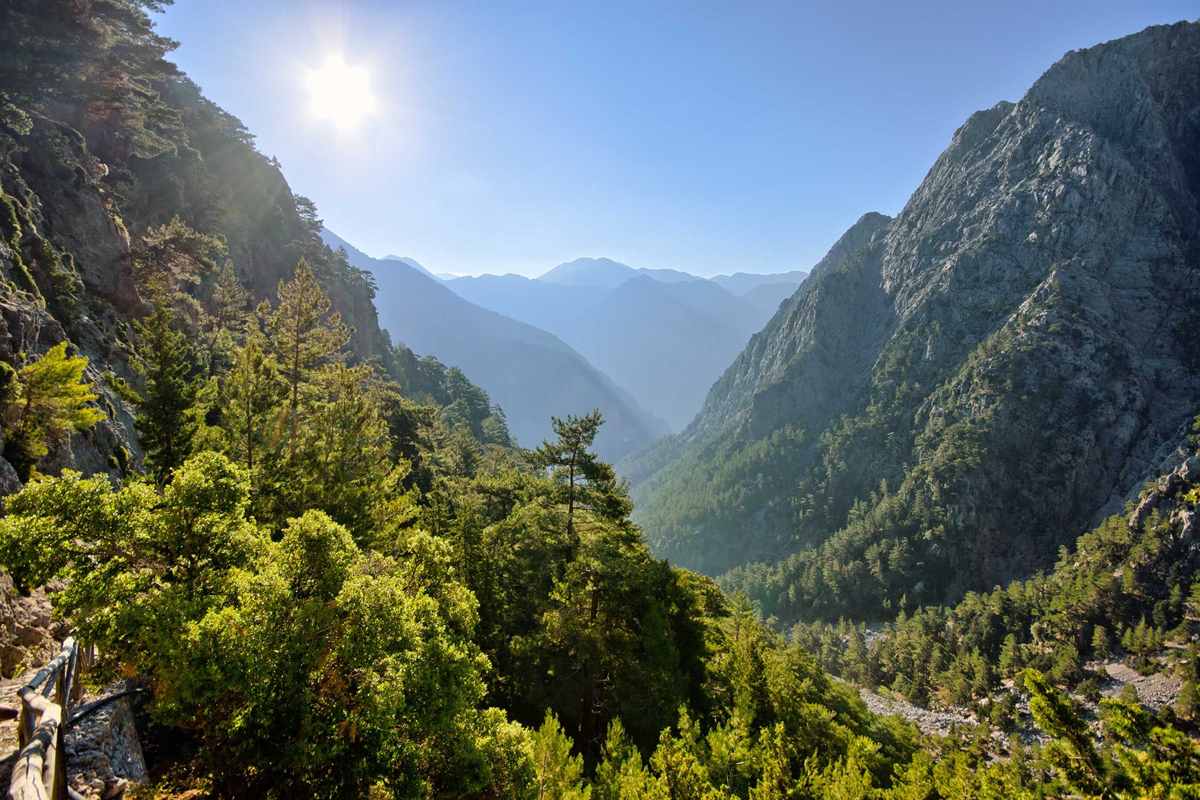
An Imbros gorge hike walks down the gorge from the mountain village of Imbros towards the south coast of Crete in Sfakia, between rock walls that close in to a narrow passage. The hike is one of the Greece Tours on Greece Ville, listed with the other Crete tours and Greece hiking tours.
This post covers the formats on sale, the gorge and how it formed, the retreat of 1941, Sfakia and its people, Hora Sfakion, Frangokastello and the questions that come up before booking.
What is an Imbros gorge hike in Crete?
An Imbros gorge hike is a walk down the Imbros Gorge from the village of Imbros towards the south coast of Crete. The gorge lies in the Sfakia area of the Chania regional unit and ends at the village of Kommitádes.

The gorge carries the Greek name Faragi Imbrou. It is an 11 km long canyon near Hora Sfakion in southern Crete. Its walls belong to the White Mountains, also known as the Lefka Ori.
The walk starts at Imbros village, also called Nimbros. The village sits at an altitude of 780 metres. It stands at the south end of the fertile plain of Askyfou, on the road to the coast.
A local legend tells of two brothers banished from Imbros in Turkey. The brothers made their home in the Cretan village of the same name. The village gives its name to the gorge below.
An Imbros gorge hike takes place in the Chania regional unit, which covers the westernmost quarter of Crete. Sfakia is one of its seven municipalities, alongside Chania, Apokoronas and Platanias.
- Finish: The walk ends at the village of Kommitádes, near the south coast.
- Season: The gorge is passable all year round, except in heavy rain or snow.
- History: The gorge saw the evacuation of thousands of British soldiers during World War II.
- Old trail: Before the road was built, a mule trail through the gorge was the only link between Chania and Hora Sfakion.
After an Imbros gorge hike, a taxi from Kommitádes returns walkers to a car parked at Imbros. Others walk back up through the gorge on foot.


Which formats of an Imbros gorge hike are on sale?
An Imbros gorge hike is on sale in formats that leave from Chania, Rethymno or Heraklion. Listed options add a pickup and return transfer, a beach or swim stop, Frangokastello, the Libyan Sea or Sfakia to the gorge walk itself.
Chania appears in eight of the nine listed titles. One format leaves from either Rethymno or Chania. A separate format sets off from Heraklion and pairs the gorge with the Libyan Sea.
One listing states that a Chania pickup and a return transfer are included. A plain hike from Chania appears under its own title. Both formats place the walk itself at the centre of the outing.
Three titles add a stop by the sea. One pairs the hike with beach relaxation. Another adds Frangokastello Beach. A third combines the gorge with Sfakia and a swim.
Two titles name the Libyan Sea. One is a Chania tour and the other is a led trip from Heraklion. A further Chania format presents the Imbros gorge hike as a tour of nature and history.
- Departures: Chania, Rethymno and Heraklion appear as starting points.
- Transfers: One Chania format includes a pickup and a return transfer.
- Coast stops: Beach relaxation, Frangokastello Beach and a swim in Sfakia appear in the titles.
- Libyan Sea: Two formats pair the gorge with the Libyan Sea.
Walkers who want other trails besides an Imbros gorge hike can compare a Chania hiking tour. The tour cards and availability boxes on this page list live dates for each format.
What are the length, walls and path of an Imbros gorge hike?
An Imbros gorge hike covers 8 km of a canyon 11 km long and drops 650 m. The limestone walls close in to 1.60 m at the narrowest point. The path crosses the round scree of a dry creek bed.
The full canyon measures 11 km. The section walked on an Imbros gorge hike is shorter, at 8 km downhill. The route ends at the village of Kommitádes, near Hora Sfakion.
The gorge cuts through the White Mountains, a range made mainly of limestone. The rock ranges from light grey to bluish or black. These limestone walls rise on both sides of the creek bed.
At its narrowest part, the gorge is only 1.60 m wide. This pinch point is the tightest stretch of the route. Elsewhere the canyon floor is wider between the limestone walls.
The path follows a dry creek bed covered in round scree. The walk is strenuous on this loose surface. Shoes with ankle support are the recommended footwear for the descent.
- Length: The canyon runs for 11 km, and the walked section covers 8 km.
- Descent: The path drops 650 m between Imbros and Kommitádes.
- Narrowest point: The walls stand 1.60 m apart at the tightest stretch.
- Highest peak: Pachnes, at 2,453 m, is the highest summit of the White Mountains.
The modern road to Hora Sfakion hugs the western slope of the gorge, above the path of an Imbros gorge hike. Remains of the older mule trail can still be seen.
How did the canyon walked on an Imbros gorge hike form?
An Imbros gorge hike passes through a canyon, a deep cleft between cliffs. Such clefts form through weathering and the erosive work of a river over geologic time, as water cuts down through layers of rock. The rock here is limestone.
Canyons commonly form through long erosion from a plateau or table-land level. The White Mountains hold plateaus at 500 to 1,100 metres, among them Askifou and Impros.
Cliffs appear where harder rock strata resist erosion and weathering. These strata stay exposed on the valley walls. The limestone of the White Mountains forms the walls along an Imbros gorge hike.
Canyons also form in limestone areas. Limestone dissolves to a certain extent, so cave systems open up in the rock. When a cave system collapses, a canyon is left behind.
Water also seeps into cracks and freezes, pushing the rocks apart. This process is called frost wedging. Snow covers the peaks of the White Mountains until late in spring.
- Place name: By the prevailing theory, the name Sfakia comes from the ancient Greek word σφαξ, meaning land chasm or gorge.
- Direction: The gorges of Sfakia run from north to south and end in the sea.
- Gorge count: The White Mountains contain about 50 gorges, and Imbros is one of them.
- Caves: Gourgouthakas and the Cave of the Lion in the White Mountains both reach depths greater than one kilometre.
Walkers who finish an Imbros gorge hike can compare a Samaria Gorge tour, which covers another canyon of the White Mountains. Both gorges cut through the same limestone peaks.
Which wartime retreat followed the route of an Imbros gorge hike?
An Imbros gorge hike follows the route that Allied troops used in their retreat to Sfakia at the end of the Battle of Crete in 1941. Thousands of British soldiers passed through the gorge before ships carried them to Egypt.
Once the battle was lost, Freyberg ordered his troops to withdraw to the south coast for evacuation. The garrisons at Souda and Beritania fell back along the road to Vitsilokoumos, north of Sfakia.
On the evening of the 27th, a German detachment broke through near Imbros Gorge. It threatened a column of unarmed men. Four soldiers led by Cpl Douglas Bignal held off the attack and gave their lives.
The four included Pte Willy Falconer of the Maori battalion, LCpl Philip Stamp and Pte Andrew Payton. Their stand secured the withdrawal of the rest of the column towards the coast.
From Sfakia, four destroyers carried 1,100 soldiers on one night. About 6,000 men left on cruisers and destroyers the next night. Two destroyers later took off another 1,400.
- Local help: People of Sfakia helped Australian and New Zealand soldiers escape in 1941 and suffered great reprisals.
- Royal escape: King George II of Greece had already left by the same route when the Germans invaded.
- Last lift: The cruiser Phoebe and four smaller vessels carried more than 3,500 troops to Alexandria.
- Surrender: On 1 June, the remaining 5,000 defenders at Sfakia surrendered.
Hora Sfakion suffered badly from bombardment during the battle and the naval evacuation. An Imbros gorge hike today ends close to that harbour.
Who are the people of Sfakia, home of the Imbros gorge hike?
An Imbros gorge hike lies within Sfakia, a mountainous area in southwest Crete. Its people, the Sfakians, are known for resistance to foreign rule and for hospitality. The 2021 census counted 2,002 inhabitants across 467.589 km2 of land.
Sfakia is counted among the places in Greece that have never been fully occupied by foreign powers. It is one of the largest and least densely populated municipalities on Crete.
The White Mountains to the north and the rocky beaches to the south helped locals fight off invaders. Patrick Leigh Fermor wrote about the tall, proud Sfakians and their resistance to occupation.
Daskalogiannis, born Ioannis Vlachos in Anopolis, was a wealthy shipbuilder and shipowner. He led a revolt against Ottoman rule that began on 25 March 1770. He was executed in Heraklion on 17 June 1771.
Sfakians are also known for hospitality towards guests. Families now run their own small hotels and restaurants. The local speciality, Sfakian pies, are thin pancakes filled with mizithra cheese and drizzled with honey.
- Province: The province of Sfakia, part of the Chania Prefecture, was abolished in 2006.
- Airport: The international airport of Chania bears the name of Daskalogiannis.
- Research: The University of Oxford has carried out a field survey of the archaeology and history of Sfakia.
- Footpath: The European hiking footpath E4 crosses Crete through the mountains of Sfakia.
An Imbros gorge hike crosses this land from the Askyfou plain to the coast. The church of Panagia Thymiani, where the revolution of 1821 began, stands near Kommitádes.
What is Hora Sfakion, the port at the end of an Imbros gorge hike?
An Imbros gorge hike ends near Hora Sfakion, a small town on the south coast of Crete. The town is the capital of Sfakia and lies 74 km south of Chania, with two small harbours and 322 inhabitants at the 2021 census.
Ferry boats from Agia Roumeli dock at the two harbours. From Hora Sfakion, ferries also sail to the nearby coastal village of Loutro and to Gavdos, the southernmost island of Europe.
The harbourfront holds tavernas, two minimarkets, a butcher shop and a bakery. A quiet local beach lies on the west side of the village. Rooms, studios and apartments serve visitors.
The local economy rests on tourism, fishing, olive oil production and sheep and goat herding. Up to the 18th century, the town carried on a flourishing trade with its own small fleet.
Hora Sfakion was said to have had a hundred churches. It prospered under Venetian and Ottoman rule. The town is also known as a centre of resistance against both occupying powers.
- Position: The town lies on the south coast near the end of the Imbros Gorge.
- Loutro: The car-free village of Loutro is reachable only by boat from Sfakia.
- Coast: The coastal villages of Sfakia have no coastal road and are reached by ferry boats.
- Province seat: Hora Sfakion served as the seat of the former Sfakia Province.
After an Imbros gorge hike, the drive back north crosses the White Mountains. A Crete jeep safari explores other mountain roads on the island.
What is Frangokastello, the coastal castle near an Imbros gorge hike?
An Imbros gorge hike from Chania can add Frangokastello, a castle and scattered settlement about 12 km east of Hora Sfakion. The Venetians built the castle between 1371 and 1374 to impose order on Sfakia and to deter pirates.
The Venetians named it the Castle of St. Nikitas after the nearby church. Local people called it Frangokastello, the Castle of the Franks, meaning Catholic foreigners. The name stuck, and the Venetians adopted it as well.
Local lore tells of six Patsos brothers from the settlement of Patsianos. They destroyed every night what the Venetians built during the day. The brothers were later betrayed, arrested and hanged.
The castle has a simple rectangular shape with a tower at each corner. Remains of a Venetian coat of arms sit above the main gate. The battlements date from the Ottoman occupation.
In 1828, Hatzimichalis Dalianis from Epirus occupied the castle with Sfakiots and Epirotes. The Turks besieged and massacred them. Tradition tells of the Drosoulites, shadows that seem to march towards the fortress around dawn.
- Beach: The settlement has an extensive, sheltered and gently shelving sandy beach.
- Capture: Turkish forces captured the rebel Daskalogiannis at Frangokastello.
- Siege: The Greek force lost 350 men after a seven-day siege of the fort.
- Dew shadows: The shadows of the Drosoulites are visible from the valley at a distance of 1000 m.
One listed format pairs an Imbros gorge hike with Frangokastello Beach. Tourist accommodation is scattered over the flat plain around the castle, and the area has seen little major development.
What do travellers ask about an Imbros gorge hike?
An Imbros gorge hike raises four common questions. They cover departure towns, beach stops, the wildlife of the White Mountains and the Venetian castle at Frangokastello. The answers below draw on the listed formats and on published reference sources.
Does an Imbros gorge hike leave from Chania, Rethymno or Heraklion?
Yes. Listed formats of an Imbros gorge hike leave from all three towns. Chania appears in eight of the nine titles, and one title pairs Rethymno with Chania. A single format sets off from Heraklion and adds the Libyan Sea. One Chania listing includes a pickup and a return transfer.
Is a beach stop part of an Imbros gorge hike?
Yes, in certain formats. One Chania title adds beach relaxation to the hike. Another adds Frangokastello Beach, about 12 km east of Hora Sfakion. A third combines the gorge with Sfakia and a swim. The plain Chania hike and the transfer format name no beach stop, so the stop depends on the format.
Which animal lives in the mountains above an Imbros gorge hike?
The kri-kri, also called the agrimi, lives there. It is a feral goat, Capra hircus cretica. The peaks of the White Mountains of west Crete are its last strongholds. It has a light brownish coat and two horns that sweep back. About 2,000 animals remain on the island, and hunting them is strictly prohibited.
What is Frangokastello, the stop on one Imbros gorge hike?
Frangokastello is a castle and scattered settlement on the south coast of Crete, about 12 km east of Hora Sfakion. The Venetians built the castle between 1371 and 1374 as a garrison. It has a rectangular plan with a tower at each corner and stands on a wide sandy beach.