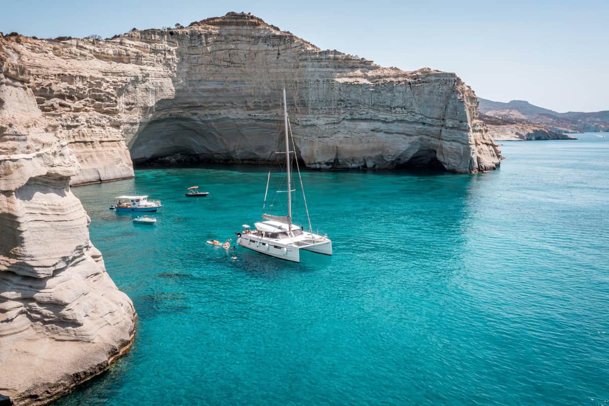
A Milos sailing tour is a day on the water around the island of Milos in the Cyclades. The route passes white cliffs, sea caves and small coves. It is one of the sailing tours in Greece on Greece Ville.
This post covers what a Milos sailing tour is, where it goes and the Kleftiko caves. It also covers the volcanic coast, the sea life and how sailing works. History, the best season and common questions come last.
The sections include Milos sailing tours and related boat trips that can be booked online.
What is a Milos sailing tour?
A Milos sailing tour is a trip by sailing boat along the coast of Milos. Boats for these trips mostly leave each day from the ports of Adamas and Pollonia. They sail past cliffs, coves and beaches that roads do not reach.
Milos lies 102 km, or 55 nautical miles, from Cape Maleas on the Peloponnese. Ferries from Piraeus can stop at Kythnos, Serifos and Sifnos on the way. Sometimes they also stop at Kimolos before reaching Milos.
The island has a horseshoe shape around a big gulf. This gulf is one of the largest natural harbours in Greece. Inside the gulf, a Milos sailing tour meets calm water. Chondro Vouno, at 636 metres in the west, is the next highest peak after Profitis Ilias.
Visiting boats moor in the marina of Adamas or at Pollonia. The marina of Adamas offers fuel, water and electricity. Coves such as Provatas, Kleftiko and Paliochori also suit mooring. The choice depends on the wind direction.
A list of 90 Milos beaches shows how long the coast is. It puts 25 inside the gulf and 21 on the south side. The north has 17, the west 15 and the east 12. A Milos sailing tour can reach beaches that cars cannot.
- Agios Dimitrios: This beach at the west end of the bay can only be reached by boat.
- Achivadolimni: The largest beach on Milos takes its name from a pond full of clams opposite it.
- Papikinou: This beach lies 1 km east of Adamas and has among the mildest waves on the island.
- Fourkovouni: This tiny fishing village has a small beach and colourful syrmata, or seaside boat shelters.
Empourios, inside the bay, is an old commercial port with a beach. Lagkada is the nearest beach to the port of Adamas. A Milos sailing tour that starts in Adamas passes both places early on.


Where does a Milos sailing tour go along the coast?
A Milos sailing tour follows the coast past white rocks, fishing villages and coloured cliffs. On the north side, boats pass Sarakiniko, Papafragas and Mandrakia. Near the bay entrance sits the village of Klima. In the south they visit Provatas, Paliochori and Gerontas.
Sarakiniko lies about 5 km from Plaka, the capital of Milos. Its name comes from Saracen pirates who sheltered in its sea caves. Old ship bollards, posts for tying ropes, are still carved into the rock.
The Sarakiniko formation is a rock unit about 50 metres thick. It began to form 1.85 million years ago. Fossils of shellfish, sea snails, sea urchins and barnacles have been found in it. The sandy beach there is only about 10 metres long.
Papafragas beach is reached by climbing down a steep cut in the rock. In Byzantine times it served as a base for pirates. Mandrakia is a fishing village with a sandy beach of about 150 metres. Fine dark grey pebbles and tamarisk trees line it.
The syrmata are dug into volcanic tuff, a soft rock, beside the sea. They stand mainly at Klima, Mandrakia and Firopotamos. At the edge of Firopotamos stand an abandoned loading ladder and the church of Agios Nikolaos.
Klima sits at the entrance to the bay, below the village of Trypiti. It was declared a traditional settlement in 1978. A Milos sailing tour passes close to these old shores and their boat shelters.
- Kastanas: Just south of Pollonia, this beach has no sand but red, orange and purple rocks.
- Paliochori: This beach is almost 2 km long, with red, pink, yellow and white-grey rocks.
- Provatas: Three small coves split by rocks hold golden red sand coloured by iron oxides.
- Gerontas: This white cove of cliffs and caves has a bridge-shaped rock between sea and land.
An ancient harbour lies at Agia Kyriaki on the south coast. Its old storage rooms still survive. A Milos sailing tour on the south side links these colourful beaches with the caves of Kleftiko.
What are the Kleftiko caves on a Milos sailing tour?
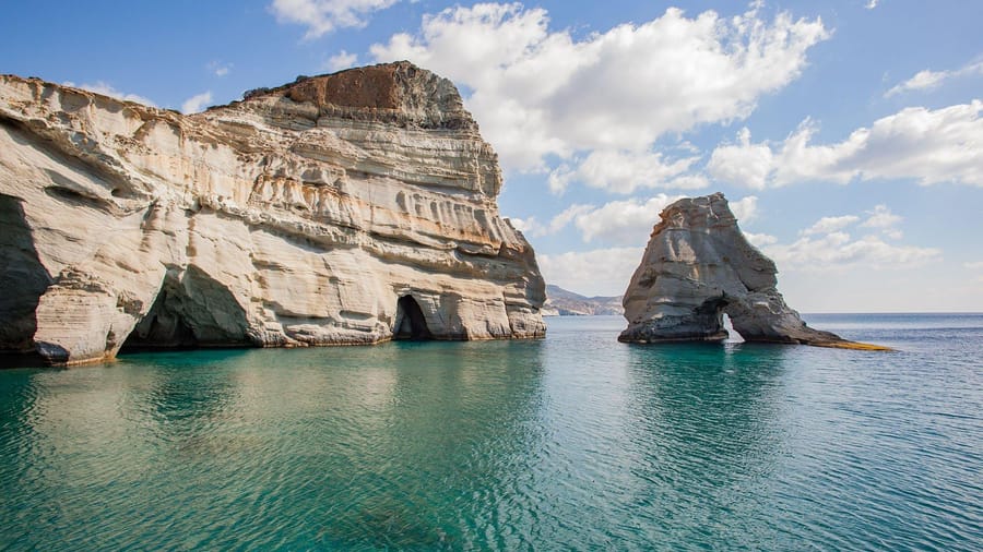
A Milos sailing tour visits Kleftiko, a stretch of white cliffs, islets and sea caves in south-west Milos. The cliffs spread across three small coves side by side. The best view is from the sea. The caves also served as shelters in bad weather.
The Kleftiko rocks are tuffs, a kind of volcanic rock. They range from white and yellowish-white to ash-black. Fine volcanic material, pumice and volcanic glass are firmly cemented together in them.
The tuffs here are a pumice breccia that formed about 3.1 million years ago. Breccia is rock of coarse, angular broken pieces held by finer material. Its name is Italian for rubble. The pumice at Kleftiko lies in layers.
Pumice is full of gas bubbles, from 64 to 85 percent of its volume. So it floats on water. Basalt, another rock, is also found in the area. A Milos sailing tour shows these layers up close from the deck.
Sea stacks, tall rocks standing alone in the sea, tend to form in layered volcanic or sedimentary rock. Erosion goes on after a natural arch forms. In the end every arch collapses and leaves a stack. Waves later wear the stack down to a low stump.
- Protection: Kleftiko is listed in Greece as a Landscape of Special Natural Beauty.
- Size: The protected landscape covers 523.20 hectares with a perimeter of 12.9 km.
- No buildings: The area has no buildings or other structures at all.
- No paths: Steep rocks mean footpaths cannot be opened through the landscape.
Since no paths reach the coves, a Milos sailing tour is the natural way to see the caves. Kipos beach has a small port where boats set off for Kleftiko.
How did volcanoes shape the coast seen on a Milos sailing tour?
A Milos sailing tour passes a coast built by volcanoes. Volcanism here began between 3.5 and 3.15 million years ago. Early eruptions happened under the sea, and later the rocks rose above it. Heat, hot water and wind then shaped the shore.
The story starts deep underground. The African plate, a huge slab of the Earth’s crust, sinks under the Aegean. Today it lies about 90 km below Milos. For its first 2 million years, the Milos volcano erupted under the sea.
The cliffs seen on a Milos sailing tour hold lavas and ash layers. These range from andesite to rhyolite, two kinds of volcanic rock. Nearly all rocks from the last 1.48 million years are rhyolite. A rock is called tuff if volcanic ash makes up over 75% of it.
Two pumice cones grew on Milos in the last 0.6 million years. Pumice is a light volcanic rock. Trachilas sits in the north and Fyriplaka in the south. Both cones hold layers of rhyolite pumice and lava up to 120 m thick.
Trachilas erupted between 0.63 and 0.32 million years ago. Volcanic glass formed here too. Obsidian has no crystals, so it is not a true mineral. The obsidian of Bombarda near Adamas formed about 1.54 million years ago.
- Steam blasts: These went on in eastern Milos, with deposits dated between 200 BCE and 200 CE.
- Kaolinite: Hot fluids turned rock in central Milos into this clay, which is mined there.
- Sea vents: Hot vents cover about 34 km² of seabed around Milos, down to more than 100 m.
The sea still shows this hot past on a Milos sailing tour. Shallow vents in Paleochori Bay release water at between 25 and 119 °C. Strong winds full of sand act like a sandblaster. They wear down and polish soft rock.
What sea life lives along a Milos sailing tour route?
A Milos sailing tour route crosses waters home to monk seals, seagrass meadows and reef fish. A 1999 count found 25-40 seals around the island group. Falcons nest in the west of Milos. Octopus and jellyfish live in these waters too.
The seal count covered Milos, Antimilos, Kimolos and Polyaigos. It found Mediterranean monk seals of varying ages. In west Milos, a mother seal uses one submerged sea cave. There she gives birth and nurses her pup.
Monk seals breed in sea caves along Polyaigos and Kimolos. The sea between these islands is mostly less than 30 m deep. Births peak in September, October and November. Only 29% of pups born between September and January survive.
Seagrass covers the seabed below a Milos sailing tour route. Posidonia is named after Poseidon, the Greek god of the sea. It grows through the whole marine part of the west Milos site. Its creeping stems grow only 1 to 6 centimetres a year.
Cymodocea, called little Neptune grass, grows along the north coast. Its narrow leaves reach 40 centimetres long. The salema, a silver fish with golden stripes, eats seagrass. Eating this fish once caused frightening hallucinations that lasted 36 hours.
- Dusky grouper: This fish lives on rocky reefs near Posidonia beds and starts life as a female.
- Common octopus: It has three hearts and changes colour to blend in with its surroundings.
- Mauve stinger: This jellyfish flashes light when waves stir the water, and even dead ones can sting.
Birds fill the sky above a Milos sailing tour as well. A large colony of Eleonora’s falcons nests in west Milos, Antimilos and Polyaigos. These falcons breed in late summer. They feed their chicks on small birds migrating over the islands.
The bird protection area of west Milos, Antimilos and Polyaigos covers 9253.52 hectares. The European shag is one of the deepest divers of the cormorant family. It has been recorded diving to 61 m.
How does sailing work on a Milos sailing tour?
A Milos sailing tour runs on wind, sails and a keel under the hull. The keel works like an underwater wing. It fights the sideways push of the wind. The crew makes the sails smaller when the wind grows strong.
A sailboat without a keel or another underwater fin only moves downwind. With the wind behind the sail, drag becomes the main pushing force. As the boat moves forward, the keel makes lift. This lift lets the boat sail across the wind.
A small sideways drift still happens, called leeway. On a Milos sailing tour, the navigator adjusts the course to make up for it. Small boats can use a centreboard that pivots up into the hull. A daggerboard slides up instead, which helps in shallow water.
A boat that heels, or leans over, tends to turn towards the wind. This is called weather helm, so the helmsman steers against it. Reefing makes a sail smaller in strong wind. A cruising mainsail has two to three sets of reefing points.
Smaller sails on a Milos sailing tour also lower the centre of effort. This cuts the heeling force and keeps the boat upright. In extremely heavy weather, the crew lowers the mainsail. A much smaller trysail goes up in its place.
- Standing rigging: The forestay, backstay and side shrouds are fixed wires that hold up the mast.
- Sail edges: The luff is the front edge, the leech the back and the foot the bottom.
- Tell-tales: These strips of yarn, thread or tape show how air flows over a sail.
Sail makers choose polyester, known as Dacron. The fibre is tough, resists sunlight and costs little. The word starboard comes from the Old English steorbord. It names the side where boats carried their steering oar.
Speed at sea uses its own units. A nautical mile is exactly 1,852 metres. One knot is one nautical mile per hour. On a Milos sailing tour, the helmsman picks the angle that gives the fastest gain towards the target.
What history does a Milos sailing tour pass?
A Milos sailing tour passes coves and coasts full of old stories. Stone Age traders took obsidian, a volcanic glass, from these shores. Ancient Melos fought Persia and later faced Athens. Rock-cut fishing ports and old mines still line the water.
Obsidian is a volcanic glass. It came from two hills in eastern Milos, Sta Nychia and Demenegaki. Pieces of it turn up in Franchthi cave in the Argolid. They lie in Upper Palaeolithic layers from the 11th millennium BC.
Phylakopi lies on the north coast. In its third period, the town had cyclopean walls of huge stones. The walls were more than 6 metres thick. Archaeologists also found a piece of a tablet in Linear A, the Minoan script.
In 480 BC, Melos refused to submit to Persia. It sent two fifty-oared ships to fight at the Battle of Salamis. In 426 BC, Athens sent 2,000 men to raid the Melian countryside. A Milos sailing tour passes the same shores.
- Melian Dialogue: Thucydides wrote it in Book 5, chapters 84–116, of his History of the Peloponnesian War.
- Venus de Milo: A French sailor, Olivier Voutier, watched it emerge and urged more digging.
- Catacombs: Their 126 carved arched tombs survive in caves about 150 metres above sea level.
- Syrmata: The name of these rock-cut boat sheds comes from fishermen dragging boats out to the sea.
In 1537 the pirate Hayreddin Barbarossa occupied Milos. Locals called the early Christian catacombs the “Greek Cave”. They had been badly looted before Ludwig Ross visited in 1844. In 2009 the Holy Synod declared Milos a sacred island because of its catacombs.
A Milos sailing tour also passes old mining coasts. Baryte was mined on the island until 2000, and sulfur until the mid-20th century. In Roman times, coastal works at Agia Kyriaki and Paliochori processed and stored mineral earths.
When is the best time of year for a Milos sailing tour?
A Milos sailing tour runs best from late spring to October. June is dry, with only 3.3 mm of rain. July and August are the hottest and windiest months. Late spring and early autumn bring milder days and calmer seas.
The Milos climate figures use NOAA climate normals for 1961–1990. The fifth month of the year averages a daily high of 22.8 °C. April averages 18.4 °C, almost the same as the 18.0 °C of November. Both edges of the season stay mild.
Day and night together, June averages 23.5 °C and August 24.6 °C. July nights average a low of 21.8 °C. Record highs reach 41.0 °C in July and 39.8 °C in August. A Milos sailing tour in midsummer needs shade and water.
The etesian winds are also called meltemia in Greek. They start in late spring and last until October. They blow on more days in July and August. Aegean air stays cooler than the air over the Ionian Sea or the mainland. The gap between day and night is smaller too.
Sailors measure wind on the Beaufort scale. Force 4 is a moderate breeze of 11–16 knots, or 20–28 km/h, with waves of 1–2 m. Force 5 is a fresh breeze of 17–21 knots. Its waves reach 2–3 m, with plenty of white horses, or foam crests.
- Driest stretch: July and August each average just 0.1 days with at least 1 mm of rain.
- First wet month: October brings 42.9 mm of rain after the dry summer.
- Winter rain: November averages 60.7 mm of rain, and December has 9.0 wet days.
- Humidity: June has the lowest relative humidity, 58.8 %, and November the highest, 73.9 %.
A Milos sailing tour also meets warm water. The warm surface layer of the Aegean Sea is about 40–50 m thick. Winter is cold by contrast, with January and February nights averaging lows of 8.5 °C.
What do travelers want to know about a Milos sailing tour?
A Milos sailing tour raises questions about the island itself. Travelers ask about its shape, its people and its rocks. They also ask about the ancient paint, the nature on the coast and the old names of Milos.
How is the island of a Milos sailing tour shaped?
Pliny the Elder was a Roman writer. He called Melos the most circular in form of all the islands in his list. Milos lies about midway between Piraeus and Crete. The island curves like a horseshoe around its large gulf.
What is the population of the island on a Milos sailing tour?
The population of Milos peaked in 1928 at 6,562 people. The 2011 census counted 4,977 people. The village of Triovasalos had 1,379 residents at the 2021 census. Small fishing ports such as Klima, Mandrakia, Firopotamos, Areti and Empourios sit in coves cut into soft rock.
What rocks does a Milos sailing tour pass?
Perlite is a volcanic glass. It forms mainly when obsidian takes up water. Heated to 850–900 °C, it swells to 7–16 times its first size. Pozzolana is volcanic ash. The Romans mixed it with lime to make concrete, even for building underwater.
Which ancient paint comes from the shores of a Milos sailing tour?
Melian earth came from the island. It was mostly kaolin, a fine clay. The painter Apelles used it as one of his four basic colours. Workshops on Melos also made flat clay reliefs from about 470 to 416 BC. They mostly showed scenes from Greek myths.
What nature lies near the coast on a Milos sailing tour?
Achivadolimni is the largest natural wetland in the Cyclades. Migrating birds stop there. Its name comes from achivades, the clams that once filled it. Milos also has a rare forest of cypress trees with flat, sideways branches. A number of them are centuries old.
What old names did the island of a Milos sailing tour have?
An ancient writer said the island was first called Byblos. Its first settlers came from the Phoenician city of Byblos. Pliny the Elder listed more names: Memblis, Zephyria and Mimallis. Aristides, Aristotle and Callimachus used them in turn. Coins of ancient Melos carried ΜΑΛΙΟΝ, meaning “of the Melians”.