
Rhodes tours are trips across the largest island of the Dodecanese, from the walled Old Town and Lindos to the ancient cities, the valleys and the coast. The page is part of the Greece Tours on Greece Ville.
This page covers what Rhodes tours are, the Old Town and the Knights, Lindos, Kamiros and Ialysos, the inland valleys and the south. Boat, catamaran and ATV trips, Symi, Marmaris, the cruise port and common questions follow. Each section links to the Greece Ville posts on single tours.
What are Rhodes tours and what do they cover?
Rhodes tours are organised visits to an island in the Dodecanese shaped like a spearhead, with a walled medieval city, ancient hill-top cities, a butterfly valley, a southern cape and mountain villages, all reached by road from the main town.
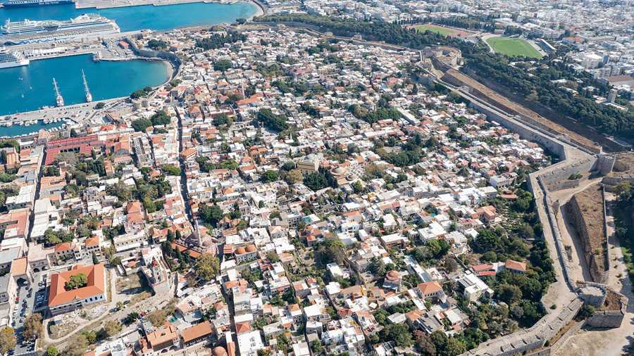
The island is shaped like a spearhead, 79.7 km long and 38 km across at its widest point. Rhodes tours therefore follow a long line from the main town at the northern tip to the south.
The island lies 363 km east-southeast of the Greek mainland and is the ninth largest island in the Mediterranean Sea. Its coastline runs for about 220 km, and the main town sits at the northern end.
The municipality counts 43 towns and villages. By 2022 the population of the island had grown to 125,113 people, while the city of Rhodes alone held 50,636 inhabitants at the census of 2011.
The sections below follow Rhodes tours from the walled Old Town to the palace of the Knights, Lindos, three ancient cities, the butterfly valley, the southern cape and the west-coast villages.
- Bedrock: Limestone is the main rock beneath the island.
- Crops: Citrus fruit, wine grapes, vegetables and olives grow on the arable strips of land.
- Interior: The central hills are mountainous and thinly settled.
- Roads: The road network radiates from the main town along the east and west coasts.
Rhodes tours therefore suit themed days, such as the Knights, the ancient cities or the southern coast, and each one needs its own route from the main town.


How do Rhodes tours explore the Old Town?
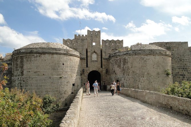
Rhodes tours enter the walled Old Town, the largest active medieval town in Europe, where the Knights Hospitaller strengthened older Byzantine defences into a belt of bastions, moats and gates that still separates the old quarter from the modern city.
The Knights used the Theodosian walls of Constantinople as the reference model. They built with rubble masonry, a technique that gives a great mass able to withstand gunshots, with smooth outer stone faces to prevent climbing.
Rhodes tours cover an area that Grand Master Antonio Fluvian de Riviere enlarged to about 42 hectares. The wall curtain was finished between 1457 and 1465, and over 6,000 people live inside.
Different Langues, or tongues, of Knights defended different stretches. The Grand Master held the north face, and the posts moving west and south went to France and Alvernia, Spain, Germany and Italy.
Rhodes tours pass the Gate of St John, called the red door because tradition says so great a number of men fell before it in 1522 that the stones were dyed red.
- Gate of St Athanasios: It was built in 1441 and 1442, and Turkish tradition holds that the troops of Suleiman entered through it.
- Naillac Tower: Built between 1396 and 1421, it rose 46 m and served as a watch tower.
- Liberty Gate: The Italians opened it in 1924 and built it in the medieval style.
- Marine Gate: This was the main entrance from the harbour, and its towers served display more than defence.
The Rhodes Old Town tour post covers the walk through the old quarter itself, while Rhodes tours as a whole place it beside the other sights of the island.
What do Rhodes tours show at the Palace of the Grand Master?
Rhodes tours reach the Palace of the Grand Master, a Gothic castle called the Kastello, which served as headquarters of the Knights of Rhodes, was rebuilt in the twentieth century by the Italian authorities and now works as a museum.
The Knights Hospitaller converted an older fortress into their administrative centre and the palace of their Grand Master. A recent study places the foundations of an ancient temple of Helios beneath the building.
The Italian authorities rebuilt the palace between 1937 and 1940. With no remains or documents from the Knights’ era to follow, the work has been criticised for a lack of historical accuracy.
Rhodes tours still pass a large plaque near the entrance that carries the name of Benito Mussolini, who used the rebuilt castle as a holiday residence after King Victor Emmanuel III of Italy.
Rhodes tours now enter the palace as a museum, after the Treaty of Peace with Italy of 10 February 1947 decided the transfer of the Dodecanese from Italy to Greece.
- Meeting: Papandreou and the other European Economic Community leaders met in the palace in 1988.
- Fleet: In 1480 an Ottoman fleet of 160 ships and an army of 70,000 men came to Rhodes.
- Wound: Pierre d’Aubusson was wounded in five places and still directed the battle.
- Defenders: In 1522 Philippe Villiers de L’Isle-Adam had about 7,000 men-at-arms.
Pope Adrian VI later proclaimed Villiers de L’Isle-Adam a Defender of the Faith, so the palace on Rhodes tours records both a siege that failed in 1480 and one that succeeded.
Why do Rhodes tours stop at Lindos?
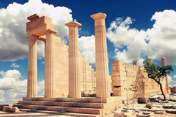
Rhodes tours stop at Lindos because its acropolis carries the Doric Temple of Athena Lindia, built about 300 BC, beneath the walls of a castle of the Knights of St John, above a fishing village on the east coast of the island.
Rhodes tours reach a municipal unit of 178.9 km2 on the east coast. By the 8th century BC Lindos was a trading centre, since its position made it a meeting place for Greeks and Phoenicians.
In the 6th century BC the town was ruled by Cleobulus, one of the Seven Sages of Greece. A stone tumulus on the northern headland of the bay is sometimes called the Tomb of Cleobulus.
The first temple of Athena Lindia, from the 6th century BC, stood above a natural cave in the cliff. Fire destroyed it in 342 BC, and a Doric temple of 7.75 by 21.65 m replaced it.
Alexander the Great and his successors offered sacrifices at the sanctuary. Visitors also see a relief of a Rhodian trireme, cut into the rock at the foot of the steps, from about 180 BC.
- Stoa: The Hellenistic stoa was 87 m long and had 42 columns.
- Excavation: Danish archaeologists of the Carlsberg Institute dug the acropolis from 1900 to 1914.
- Concrete: Italian restorers covered large surfaces with concrete, which later archaeologists judged harmful.
- Castle: The Knights built their castle before 1317 on older Byzantine foundations.
The Lindos tour post covers the village and the acropolis walk on their own, while Rhodes tours place the site beside the other sights of the east coast.
Which ancient sites do Rhodes tours visit at Kamiros, Ialysos and Filerimos?
Rhodes tours visit the Dorian city of Kamiros on the north-west coast, the area of ancient Ialysos near the town of Trianta, and Filerimos, where an icon once kept in a monastery became the patroness of the Knights Hospitaller.
Rhodes tours begin at Kamiros, 3 km west of the modern village of Kalavarda. Dorians founded the city, built on three levels, with the acropolis and the temple complex of Athena Kameiras at the top.
A covered reservoir of 600 cubic metres, built about the 6th century BC, held enough water for up to 400 families. The middle terrace held a grid of parallel streets and residential blocks.
Ialysos lies 8 km west of Rhodes city and was named Trianta until 1976. It was a village of around 2,500 people until the mid-1980s, and its windward coast now draws wind-surfers.
Filerimos kept the Byzantine icon Our Lady of Philermos, dated to the 11th or 12th century. The Knights Hospitaller took it as their patroness, and miracles attributed to it in 1480 spread its fame.
- Earthquakes: The shocks of 226 BC and 142 AD each destroyed the city of Kamiros.
- Excavation: Alfred Biliotti and Auguste Salzmann dug the acropolis from 1859 to 1864.
- Museum: Part of their finds is now kept in the British Museum.
- Icon: After 1522 it was attached to the mainmast of the carrack Santa Maria.
The icon is now kept in the Museum of Art and History in Cetinje, Montenegro, so Rhodes tours to Filerimos follow its story rather than the object.
When do Rhodes tours reach the Valley of the Butterflies?
Rhodes tours reach the Valley of the Butterflies, Petaloudes, after the wet season late in the fifth month, when thousands of Rhodes Jersey tiger moths gather among Oriental sweetgum trees whose scent attracts them and shapes a specialised habitat.
Petaloudes is the Greek word for butterflies, and the valley lies in the former municipality of the same name. That unit includes the villages of Kremasti, Paradisi, Theologos, Damatria, Maritsa and Pastida.
Rhodes tours meet the Rhodes subspecies of the Jersey tiger moth, Euplagia quadripunctaria rhodosensis. Thousands of them cover the landscape after the wet season, when the humidity of the valley is high.
Oriental sweetgum trees give off a scent that attracts the moths. Large numbers of tiger moths gather in the valley during the summer months, which makes Rhodes tours to the site a seasonal matter.
The adult moths have no stomach, and when disturbed they tend to fly repeatedly and so use up their energy. The rising number of visitors has raised concern about their population.
- Kremasti: The town lies 12 km from the main town on the airport road and had 5,597 people in 2021.
- Church: Panagia Katholiki is one of the largest churches on the island.
- Castle: The ruins of a medieval castle stand on a hill near the centre.
- Novel: The valley appears in Dorothy Dunnett’s Race of Scorpions.
Quiet movement spares the moths their energy, so Rhodes tours to the valley depend on visitors who disturb the insects as little as possible.
What do Rhodes tours find at Prasonisi and in the south?
Rhodes tours reach Prasonisi, the southern cape of the island, whose name means green island, where a sandy bar joins the cape to the rest of Rhodes in summer and steady winds draw windsurfers and kitesurfers to two different seas.
Prasonisi lies 92 km from Rhodes town, and Rhodes tours from Lindos cover 40 km to reach it. In summer it is a peninsula joined by a tombolo; in winter it becomes an island.
Wave currents build the sandy isthmus, and waves from the south-east can erode it. Vehicles once compacted the sand until parts became almost like concrete, so a line vehicles cannot cross now exists.
The cape draws surfers because the winds are predictable, steady in direction and not gusty. The Aegean Sea side has waves for advanced surfers, while the Mediterranean side has flat water for beginners.
The closest village is Katavia, and a purpose-built seasonal settlement at the cape has motels, shops, restaurants and windsurf rentals. Near the cape lies Vroulia, an ancient settlement with an old mosaic floor.
- Gennadi: The south-east village had 1,224 residents in 2021 and holds a 14th-century basilica of Agia Anastasia.
- Apolakkia: The village lies in a valley between two hills and had 409 residents in 2021.
- Kattavia: The Italians built an airstrip there during the Second World War, and it is no longer operational.
- High season: July and August make the flat water at Prasonisi very busy.
The road from Lindos to Katavia, the southernmost village, has a turning to Prasonisi, so Rhodes tours to the cape cross the whole of the south.
How do Rhodes tours cover the west-coast villages and Mount Attavyros?
Rhodes tours climb towards Mount Attavyros, the highest peak on the island at 1,215 m, and visit the west-coast villages of Embonas, Kritinia and Monolithos, where wine, shrubland, castles and a small port shape the slopes and the shore.
Mount Attavyros rises to 1,215 m south of the village of Embonas. The lower slopes carry maquis shrubland, the peony Paeonia clusii subsp. rhodia and orchids, and the Rhodes badger is among the mammals.
Rhodes tours stop at Embonas, a mountain village halfway up the rocky slopes, with 1,167 residents in 2021. A temple of Zeus stands on top, and the village is the centre of the wine industry.
The name Kritinia means New Crete, after families who escaped from Crete, and the village had 388 residents in 2021. The castle above it, called Kastellos, was built in 1472 by Giorgio Orsini.
In 1658 the Venetian Doge Francesco Morosini tried to take Rhodes by landing at the beach of Kameiros Skala, but the Venetian army was rejected. The little port there now has a ferry service to Halki.
- Municipal unit: Attavyros takes in Embonas, Kritinia, Monolithos, Siana and Agios Isidoros.
- Distance: Kritinia lies 51 km from the town of Rhodes.
- Airport: The village is 35 km from Rhodes International Airport.
- Skala: Kameiros Skala lies 5 km from Kritinia and 14 km from ancient Kameiros.
The western road joins the mountain, the wine village and the coast, and Rhodes tours that follow it see the thinly settled interior of the island.
How do boat trips fit into Rhodes tours?
Rhodes tours by boat begin in a harbour system of five ports, three of them in Rhodes city, one near Kamiros and one near Lardos, and they cross waters once sailed by a navy that Greek tradition counted among the finest.
The island is shaped like a spearhead, 79.7 km long and 38 km across at its widest. Its coastline adds up to roughly 220 km, so boats have a long shore to follow.
Rhodes lies 363 km east-southeast of the Greek mainland and only 18 km from the southern shore of Turkey. That position made the island a stopping point for merchant ships in antiquity.
Mandraki Port is the oldest port of the island and stands in the centre of Rhodes city. Kolona Port lies opposite and north of the central port and serves traffic between the Dodecanese islands and yachts of all sizes.
The Kamiros Skala dock lies 30 km south-west of the city near the ruins of Ancient Kamiros and serves mainly the island of Halki. Lardos dock sits on a rocky shore in the south-east of Rhodes.
A saying from the Hellenistic age about the Rhodian fleet ran, “If we have ten Rhodians, we have ten ships.” The proverb shows how closely the island linked its name to seafaring, which suits Rhodes tours by sea.
- Length: The island measures 79.7 km from end to end.
- Area: Rhodes covers about 1,400 km2, far more than the rest of the Dodecanese put together.
- Rank: It is the ninth largest island in the Mediterranean Sea.
- Distance: The Greek mainland lies 363 km away to the west-north-west.
The Rhodes boat trip post covers what happens on the water itself. This section only maps the harbours, so that Rhodes tours by boat can be placed on the island.
What makes catamaran trips part of Rhodes tours?
Rhodes tours by catamaran use a vessel with two parallel hulls of equal size, a design whose wide stance resists rolling and overturning, so that the boat needs no ballast and keeps a steady line across open water.
The word catamaran comes from the Tamil word kattumaram, which means “logs bound together”. It first named a single-hulled raft made of three to seven tree trunks lashed side by side.
Catamarans were invented by the Austronesian peoples, whose twin-hulled craft carried them to the islands of the Indian and Pacific Oceans. Modern catamarans take their inspiration from those Oceanian and South-east Asian boats.
The first documented twin-hulled sailing craft in Europe was designed by William Petty in 1662 to sail faster, in shallower water and with fewer crew. The unusual design met scepticism and was not a commercial success.
In a simple comparison, a catamaran has seven times the initial resistance to heeling of a single hull of equal beam. A fifty-footer needs four times the force to start a capsize, which explains the steady feel of Rhodes tours on two hulls.
- Draught: A catamaran has a shallower draught than a single hull of comparable length.
- Wakes: The wide stance can reduce wave-induced motion and leave smaller wakes.
- Beachcats: The Hobie 16 appeared in 1969, and more than 100,000 were built.
- Olympics: Catamarans joined Olympic sailing in 1976, with the Tornado class.
The Rhodes catamaran cruise post covers the trip on the island itself. This section explains the boat type, because Rhodes tours by catamaran rest on a design with a long history.
How do sunset trips work within Rhodes tours?
Rhodes tours at sunset follow the astronomical rule that sunset is the moment the upper edge of the Sun disappears below the horizon, an event that happens once every twenty-four hours except in areas close to the poles.
Atmospheric refraction bends sunlight so strongly near the horizon that the solar disc is already about one diameter below the horizon, in geometric terms, when sunset is observed.
At the spring and autumn equinoxes the Sun sets due west. From the Northern Hemisphere it sets to the north-west in spring and summer and to the south-west in autumn and winter.
Sunset is distinct from twilight, which has three stages. Civil twilight begins once the Sun has gone below the horizon and lasts until it is 6 degrees below it.
Nautical twilight covers the band from 6 to 12 degrees below the horizon, and astronomical twilight covers 12 to 18 degrees. Night begins at 18 degrees, which is the end point for Rhodes tours that chase the last light.
- Sunshine: Rhodes airport is expected to receive around 3400 hours of actual annual sunshine.
- Lindos: Its mean annual temperature of around 22.0 degrees Celsius is the warmest in Greece.
- Dusk: Dusk is the darkest moment of twilight, just before night.
- Poles: Beyond the Arctic Circle, at least one day each year has no full sunset.
The Rhodes sunset cruise post covers the evening trip on the island. This section sets out the science of the Sun, which shapes every evening of Rhodes tours.
Where do ATV trips belong among Rhodes tours?
Rhodes tours on quad bikes use all-terrain vehicles, machines with low-pressure tyres, a seat straddled by the operator and handlebars like a motorcycle, designed to cross a wider variety of ground than other road vehicles can manage.
By the current ANSI definition, ATVs are intended for a single operator. Tandem ATVs have been developed for a driver and one passenger, and side-by-side seating belongs to a separate class called utility terrain vehicles.
Royal Enfield built and sold the first powered four-wheeler in 1893. It used bicycle components, including handlebars, but it served as a form of horseless carriage for road use.
The term ATV was first coined for six-wheeled amphibious machines of the mid-1960s, such as the Jiger, the Amphicat and the Terra Tiger. Honda then launched its three-wheeled US90 in 1969 and trademarked the name All Terrain Cycle in 1973.
The interior of Rhodes is mountainous and covered with forests of pine and cypress. Mount Attavyros, at 1,216 m, is the highest point, and limestone is the main bedrock under the tracks used by Rhodes tours.
- Lindos road: National Road 95 connects Rhodes city with Lindos.
- Southern road: Province Road 1 runs from Lindos through villages to Katavia, the southernmost village.
- Network: The island has 3 national roads, 40 provincial roads and a network of local ones.
- Cross-island road: National Road 100 links the east coast with the west and the airport.
The Rhodes ATV tour post covers the off-road trip on the island. This section explains the vehicle and the ground it crosses, which is the base for every one of the Rhodes tours on four wheels.
Why is Symi part of Rhodes tours?
Rhodes tours reach Symi, a mountainous Dodecanese island of 58.1 square kilometres that lies about 15 miles north of Rhodes, and whose economy rested for centuries on shipbuilding and the sponge industry before tourism became its main trade.
In Greek myth, Symi is reputed to be the birthplace of the Charites, and it takes its name from the nymph Syme. In antiquity the island was also known as Aigli and Metapontis.
Homer’s Iliad names King Nireus of Symi as a Greek leader at Troy. Thucydides records a Battle of Syme near the island in January 411 BC, in which Spartan ships defeated an Athenian squadron.
The Knights of St John conquered Symi in 1309, and the Ottomans took it in 1522 along with Rhodes. Under Ottoman rule the island was called Sombeki and kept its privileges.
The population peaked at about 22,500 in the 19th century. In 2021 the permanent population had declined to 2,603, and visitors lift the total to as much as 6,000 between Easter and Panormitis Day.
- Museum: The renovated Historical Museum of Symi reopened in late 2020.
- Festival: The Symi Festival has run from July to September since 1995.
- Sister city: Tarpon Springs in Florida formed a sister-city link with Symi in 2008.
- Islets: The municipality includes seven uninhabited offshore islets.
The Symi day trip from Rhodes post covers the crossing and the harbour town. Symi is the island closest to Rhodes tours by sea, and this section gives its background.
What do Rhodes tours show of Marmaris across the sea?
Rhodes tours to Marmaris cross to a municipality of Muğla Province in Turkey whose population was 97,818 in 2022, a port city and resort on the Turkish Riviera that is also a centre for sailing and diving.
In 334 BC Alexander the Great invaded Caria and besieged the castle of Physkos. The town’s 600 inhabitants burned their valuables and escaped to the hills, and the invaders repaired the damaged sections.
In 1801 a British force of 120 ships and 14,000 troops anchored in the bay for eight weeks to train and resupply. The force was bound for the campaign against the French in Egypt and Syria.
The castle was partly destroyed in World War I by a French warship. The Fethiye earthquakes of 1957 almost completely destroyed the city, but the castle survived, and locals lived inside it until 1979.
- Castle: The castle now holds a museum with seven galleries, the largest used as an exhibition hall.
- Park: Marmaris National Park covers 33,350 hectares of Turkish pine forest.
- Plants: Of the 514 plant species identified in the park, 54 are endemic.
- Birds: Surveys have identified 112 bird species in the park.
The Rhodes to Marmaris day trip post covers the crossing to Turkey. This section shows what stands on the far shore, since Marmaris is the one foreign port in Rhodes tours.
How do cruise-ship visitors use Rhodes tours?
Rhodes tours for cruise passengers begin in Rhodes city, where the permanent population of 49,541 in the 2011 census grows to about 100,000 in summer because 25,000 to 30,000 hotel beds operate within the city limits.
Akandia Port is the new port of the island, built since the 1960s for domestic and cargo traffic. A passenger terminal with a cafe and waiting lounges has been in use there since the summer of 2017.
Rhodes city has two marinas, a municipal one at Mandraki and a private one beside Akandia port. Ferries link the island with the Dodecanese, the Cyclades and Piraeus, and one runs twice weekly to Heraklion.
Cruising as a form of travel has a long record. The Francesco I, built in 1831, sailed from Naples in June 1833 with nobles aboard. The Augusta Victoria carried 241 passengers in 1891 and is described as the first cruise.
As of November 2022 there were 302 cruise ships at work worldwide, with a combined capacity of 664,602 passengers. The Dodecanese group around Rhodes holds 15 larger islands and 150 smaller ones, of which 26 are inhabited.
- Airport: Diagoras Airport is the fourth biggest in Greece by passenger volume.
- Taxis: The island is served by 450 taxis.
- Buses: About 200 public and private buses add to the traffic.
- Name: Dodecanese means twelve islands in Greek, though the group is larger.
The Rhodes shore excursion post covers a day ashore from the port. The Dodecanese tours post sorts the other islands of the group, and both extend Rhodes tours beyond the quay.
What do travellers ask about Rhodes tours?
Rhodes tours raise questions about the island’s population, its visitor numbers, its climate and its farmland, and the four answers below state each figure plainly, one question at a time, with full numbers where the source gives them.
What population lives on the island behind Rhodes tours?
The island had 125,113 inhabitants by 2022. The city of Rhodes, its principal town and the seat of the municipality, was home to 50,636 people at the 2011 census. Rhodes tours therefore run on an island with a large permanent population.
What visitor numbers do Rhodes tours draw each year?
After Crete, Rhodes ranks next among Greek destinations by arrivals. Arrivals stood at 1,785,305 in 2013, 1,931,005 in 2014 and 1,901,000 in 2015. More than 550 hotels operate on the island, and Rhodes tours draw on that supply of rooms.
What climate affects Rhodes tours?
Rhodes has a hot-summer Mediterranean climate with mild winters. Lindos recorded the highest temperature ever measured on the island, 43.6 degrees Celsius. The coastal airport has never dropped below 1.2 degrees Celsius since records began in 1977, so Rhodes tours meet mild winters.
What farmland do Rhodes tours pass?
While the shores are rocky, the island has arable strips of land where citrus fruit, wine grapes, vegetables and olives are grown. The pine and cypress forests of the interior frame this farmland, and both appear along the routes of Rhodes tours.