
Antiparos boat trip crosses the strait from Paros to Antiparos, with Chora and the Loredan kastro, the cave, the islet of Despotiko, Saliagos, Agios Georgios and the beaches of the island. The trip is one of the Greece Tours on Greece Ville, listed with the other Cyclades tours and day trips from Paros.
This post covers what the trip is, the strait from Paros, Chora, the kastro, the cave, Despotiko, Saliagos, Agios Georgios, the beaches, pirates, marble and the formats on sale. Common questions come last.
What is an Antiparos boat trip?
An Antiparos boat trip is a sea outing to the small Cycladic island of Antiparos, which lies close to Paros. It follows the short channel between the two islands and can add the small uninhabited islands off the western coast.
The island of Antiparos is small, and its municipality covers it together with the uninhabited island of Despotiko. An Antiparos boat trip therefore reaches a place that holds one settled island and one empty neighbour.
The island carried the ancient name Oliaros, thought to be a Phoenician word that means wooded mountain. Later the name Antiparos arose from its position opposite Paros, as anti means opposite.
Antiparos became a community in 1914 and a municipality in 2010, under the Kallikratis Programme, which gave each island its own municipality. An Antiparos boat trip therefore visits a self-governing island.
The local economy rests on tourism, fishing and farming. The season for visitors runs from Easter to October, and the shops, restaurants and rooms of the island work within that span of the year.
- Ancient name: Oliaros, recorded by Pliny the Elder, Strabo, Virgil and Stephanus of Byzantium.
- Municipality: The island became a municipality of its own in 2010.
- Economy: Tourism, fishing and farming carry the local year.
- Setting: The island lies in the southern Aegean, at the heart of the Cyclades.
The sections below follow an Antiparos boat trip from the strait to the village, the castle, the cave, Despotiko, Saliagos and the crossing back to Paros.
What is the island across the strait from Paros on an Antiparos boat trip?
The Antiparos boat trip crosses the Strait of Antiparos, which separates the island from Paros and lies to the southwest of its larger neighbour. The island measures eleven kilometres from north to south and rises to its highest point at Saint Elias.
The island lies 8 kilometres from the port of Parikia, from which the passenger ferry runs. An Antiparos boat trip across the strait therefore starts from the main port or from the south coast of Paros.
Its greatest width reaches 4.5 kilometres. The terrain is essentially flat, broken only by small hilly peaks, and the highest summit, Saint Elias, stands in the middle of the island at 308 metres above the sea.
The vegetation of the island is low, and bougainvillea adorns the gardens, houses and shops. On an Antiparos boat trip the green of the flowers stands out against whitewashed walls and dry slopes.
Besides the main settlement, the island holds the villages of Soros and Kampos and the resort at its southwest edge. The settlements stay small, so an Antiparos boat trip covers the island in one stay.
The Paros boat trip post covers the larger island, its harbours, its coasts and the islets scattered between the two, while this post stays with the smaller island and the water around its shores.
- Length: Eleven kilometres from north to south.
- Width: A maximum of 4.5 kilometres.
- Summit: Saint Elias, at 308 metres, in the middle of the island.
- Ferry port: Parikia lies 8 kilometres away on Paros.
The strait is the reason an Antiparos boat trip needs so little distance. The two islands face each other across a narrow stretch of the central Aegean.
What does an Antiparos boat trip show in Chora?
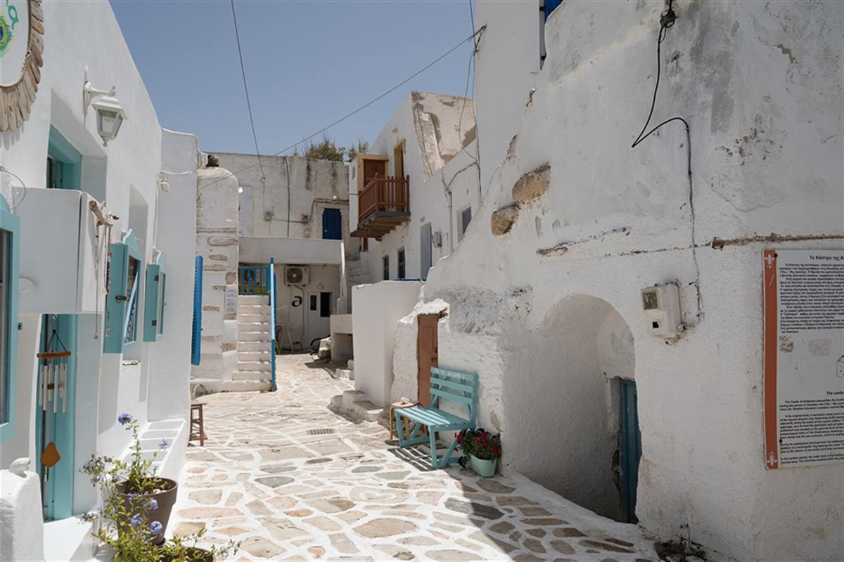
An Antiparos boat trip lands at the main settlement, called simply Antiparos, on the northeastern tip of the island. White houses, cobbled streets and bougainvillea fill a village that faces Pounda on Paros across the narrow water of the strait.
The historical centre lies inside the Venetian castle. Shopping streets connect that centre with the coastal street, so an Antiparos boat trip passes from the quay to the old walls along lanes lined with shops.
Cycladic rules on architecture apply here as on the neighbouring islands. They keep the houses white, with blue doors and windows, and they protect the stone alleys and the fences of the churchyards.
The town hall stands on a commercial road just in front of the castle, together with a clinic. Nearby lies Plaza Roussos, named after the writer of the film Madalena.
Flowers thrive in the yards of the houses, and the island is known for them. The bougainvillea spills over walls, doors and shop fronts, so an Antiparos boat trip arrives among colour and white stone.
The stone square of Agia Marina is the focus of artistic and political events. An Antiparos boat trip that stays for an evening sees the square as the social heart.
- Position: The northeastern tip of the island, opposite Pounda on Paros.
- Streets: Shopping streets run from the castle to the coastal road.
- Square: The stone square of Agia Marina hosts events.
- Plaza Roussos: The square is named after the writer of Madalena.
Chora is the base of every Antiparos boat trip. The village holds the quay, the castle and the streets that lead on to the cave and the beaches.
What is the Loredan kastro on an Antiparos boat trip?
The Antiparos boat trip passes the Loredan kastro, a Venetian castle that stands in the heart of the main settlement. Giovanni Loredan built it as a fortified village, and its houses form a continuous ring around a central mound.
The castle is an example of the fortified settlements built in the Cyclades during the period of the Latins, between the 13th and 16th centuries. Tradition links it to Loredan’s marriage to Mary Sommaripa.
The outer zone holds 24 two-storey houses. Their outer walls doubled as the defensive wall, so an Antiparos boat trip sees a village that was its own fortress, with the only entrance in the south wing.
At the centre stood a mound, a motte, which until recently carried a water reservoir. Among the houses stand three churches and the old aqueduct, and a church of Christ was later added.
The settlement later spread outside the south wing and formed a rectangular ring called Xopyrga. Any work on the old houses needs permission from the archaeological department, which protects their original features.
- Builder: Giovanni Loredan, a Venetian nobleman.
- Houses: 24 two-storey houses form the outer zone.
- Centre: A mound, later used as a water tank.
- Entrance: The only gate lies in the south wing.
Today the houses face outwards and work as shops on the main street. At dusk, small bats fly around the tower to the east, and an Antiparos boat trip that stays until evening can watch them.
What is the Antiparos cave on an Antiparos boat trip?
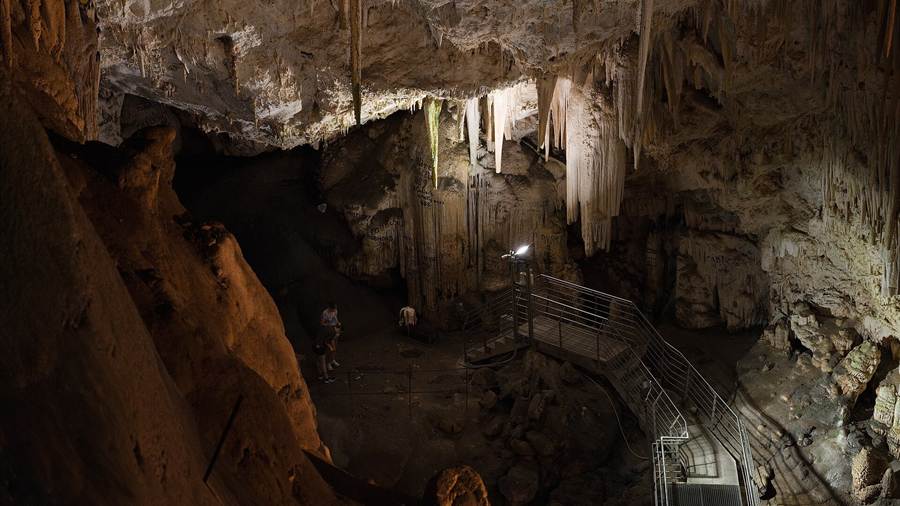
The Antiparos boat trip includes the cave in the centre of the island. The cave is very extensive and runs over a series of levels, and people have used it as a natural shelter since the Neolithic period onwards.
The area around the cave was used for pottery and also for worship of the goddess Artemis. At the entrance stands the church of Agios Ioannis Spiliotis, a church that marks the approach to the site.
The poet Archilochus of Paros left an inscription inside, according to the story. Marks on the stalactites and stalagmites include an inscription on the altar by the generals of Alexander the Great.
During the Orlov Revolt, the Russians ruled the island from 1770 to 1774. They took out the large stalactites of the cave and sent them on to the Hermitage Museum in Russia.
Signs and scratches on the stalactites and stalagmites attest to the passers who came before. An Antiparos boat trip follows a route that visitors have walked since antiquity.
The German occupation destroyed part of the cave. Loudspeakers that inform visitors, security cameras, lighting, steps and barriers came from EU funds in the late 20th century.
- Position: The centre of the island.
- Entrance church: Agios Ioannis Spiliotis stands at the site.
- Poet: According to the story, Archilochus of Paros left an inscription.
- Repairs: Barriers, steps and lighting date to the late 20th century.
Visits to the cave account for a very large share of the municipal budget. An Antiparos boat trip that includes the cave therefore supports the local economy.
What is Despotiko on an Antiparos boat trip?
An Antiparos boat trip can reach Despotiko, an uninhabited island 700 metres southwest of the shores of Antiparos. The island, anciently called Prepesinthos, holds a late Archaic sanctuary that excavators are still studying today, with finds of great importance for the Cyclades.
Boats reach the island only from Antiparos, either from the main village or from the southwest of the island. Their usual landing lies on the south of Despotiko, where a large sandy beach spreads.
The strait between the two islands has a maximum depth of about 1 metre. Seabed remains and a Classical inscription to Hestia suggest that an isthmus once joined Despotiko and Antiparos.
Excavations in 2015 revealed the facade of the Archaic sanctuary, 35 metres by 15 metres. A four-room building held a stone altar and pottery bearing Apollo’s name, and a long wall ran from the ancient port.
The English explorer Theodore Bent surveyed the islet in early 1884, and Christos Tsountas dug Cycladic cemeteries there in 1889. Artefacts from the digs stand in the archaeological museum in Parikia.
- Distance: 700 metres southwest of the shores of Antiparos.
- Views: Syros, Serifos, Sifnos, Kimolos, Folegandros, Sikinos and Ios show on clear days.
- Wildlife: The monk seal is a permanent resident of the shallow water.
- Museum: Finds stand in Parikia on Paros.
Despotiko sits close to the exact centre of the Cyclades. An Antiparos boat trip that reaches it adds a sanctuary, a quiet beach and a wide view of the archipelago.
What is Saliagos on an Antiparos boat trip?
An Antiparos boat trip passes Saliagos, a tiny islet between Antiparos and Paros that holds one of the oldest settlements of the Cycladic culture. Radiocarbon dating places the settlement in the middle to late Neolithic period, between 5000 and 4500 BC.
Saliagos is the first early farming site of the Cyclades. The settlers lived there for about 300 years, and the site has one of the earliest fortification systems known in Greece.
The islets in the strait are what remains of a land link between Antiparos and Paros. That link survived as late as the Byzantine period before rising seas submerged it.
The ceramic styles show kinship with the mainland rather than with other Neolithic sites on the islands. Small amounts of similar pottery have also been found on Naxos, so the culture stands out from its surroundings.
The pottery was made of local clay, and the vessels carry geometric patterns in matt white. Three marble figurines were found, and two abstract idols recall the shape of a violin.
The obsidian used for tools came almost exclusively from Milos, 60 km away. Ftelia on Mykonos, excavated in 1995, is now recognised as a second settlement of the same culture.
- Dating: Between 5000 and 4500 BC.
- Duration: The settlement lasted about 300 years.
- Defences: One of the earliest fortification systems in Greece.
- Burials: The burial sites sank under the sea.
Surface finds at Vouni on Antiparos are close to those of Saliagos. An Antiparos boat trip therefore links a prehistoric islet with the larger island beside it.
How does the Paros strait crossing work on an Antiparos boat trip?
The Antiparos boat trip crosses the strait that links Paros and Antiparos, a short sea route used since prehistory. A car-carrying shuttle ferry runs all day to and from Pounda, while the passenger ferry sails from Parikia.
Pounda lies 5 kilometres south of Parikia on Paros. A shuttle ferry that takes cars as well as passengers links it with the harbour of Antiparos, so an Antiparos boat trip can start there.
The passenger ferry leaves from Parikia, the port of Paros, which stands 8 kilometres from Antiparos. The two crossings differ in their starting points, but both end at the harbour of the main village.
The strait is not new as a route. Despotiko Bay offered safe anchorage in prehistoric and ancient times, and the central position among the Cyclades made the area a link in sea routes.
A dozen smaller islets surround Paros, so the water near the strait holds a scatter of small landmarks. An Antiparos boat trip passes among them before the island of Antiparos comes into view.
Boats to Despotiko leave from Antiparos and never from Paros. An Antiparos boat trip that includes the island therefore crosses the main strait first and then a second, much shallower one.
- Car ferry: The shuttle runs all day to and from Pounda.
- Passenger ferry: The route starts at the port of Parikia.
- Distance from Parikia: 8 kilometres.
- Second strait: A shallow channel separates Despotiko from Antiparos.
The crossing is part of the experience. An Antiparos boat trip begins with a sail over water that once held a land bridge between the two islands.
What does an Antiparos boat trip show at Agios Georgios?
An Antiparos boat trip can start from Agios Georgios, the resort settlement at the south-western edge of the island, just opposite Despotiko. The same cove carries a wartime story, because a secret submarine base once worked near its tip.
The main village of Antiparos lies at the north-eastern tip of the island, opposite Pounda on Paros, where the ferry arrives. Agios Georgios stands at the far end, so the whole length of the island separates the two settlements.
The island measures 11 kilometres from north to south and reaches 4.5 kilometres across at its widest point. Besides Agios Georgios, the other named settlements are Soros and Kampos, while the main town carries the plain name Antiparos.
Boats for Despotiko on an Antiparos boat trip leave either from the main village or from Agios Georgios. The second harbour sits just opposite the uninhabited island, so an Antiparos boat trip from the south-west has the shortest line across the water.
In the Second World War, a secret submarine base operated at the south-western tip, close to Agios Georgios. After the war the area became a tranquil place again, and tourism later grew around the settlement.
- Position: Agios Georgios lies at the south-western edge of the island.
- Type: the settlement is described as a resort, set apart from the harbour village in the north-east.
- Neighbours: Soros and Kampos are the two other named settlements on the island.
- Wartime: a secret submarine base used the nearby tip during the Second World War.
The south-western end therefore joins a resort settlement to a chapter of twentieth-century history, and both are visible from the water on an Antiparos boat trip.
Which beaches does an Antiparos boat trip pass?
An Antiparos boat trip passes the beaches near the main town, among them Psaralyki, the Sifneiko and Agios Spyridon, and then the bays of Soros, Glyfa, Apantima and Monastiria. The coast is a chain of small sandy shores around a low island.
Near the centre of the island, the named beaches are Psaralyki, the Sifneiko, Agios Spyridon and the camping beach. They sit in the wider area of the centre, close to the main settlement.
Further beaches include Soros, Glyfa, Apantima and Monastiria. Soros also gives its name to a settlement, so the word appears on both the shoreline and the list of villages.
The best-known stretch is the Camping beach, also called Theologians beach, at the north of the island, opposite the islet of Diplo. A boat can approach it from the water in the same way as the others.
Since the 1970s and 1980s, remote sandy beaches have drawn holidaymakers to the island. Perigiali and the far end of the town beach are nudist, while the other beaches on the island are mainly textile.
The Paros snorkeling post covers the water, the seabed and the bird life around Paros and Antiparos, for readers who plan to swim from the boat.
- Town side: Psaralyki, the Sifneiko, Agios Spyridon and the camping beach.
- Other bays: Soros, Glyfa, Apantima and Monastiria.
- North coast: the Camping or Theologians beach faces the islet of Diplo.
- Nudist stretches: Perigiali and the far end of the town beach.
An Antiparos boat trip sees these shores from a single angle, and the list of names above lets a traveller match each bay to the coastline as the boat passes.
Why do pirates appear in the story of an Antiparos boat trip?
An Antiparos boat trip crosses waters that raiders once used against the island. Pirates from Kefalonia and the Mani landed, plundered the settlement and kidnapped a daughter of the Venetian vice-consul, an event the sources call the island’s major catastrophe.
The raid ranks as the worst blow in the history of Antiparos. The attackers came from Kefalonia and from the Mani, and the raid ended in plunder and a kidnapping.
Among their captives was the daughter of the Venetian vice-consul, so a Venetian official was part of island life even after the Venetian lords had gone. That kidnapping gave the raid its lasting place in local memory.
Piracy in the Cyclades was not new. Pirates from Samos invaded Sifnos, the western island between Serifos and Milos, in the sixth century BCE, and the event entered the island’s recorded history.
The Sifnos boat trip post covers the coast of that neighbouring island from the water, and it suits readers who wish to compare the two islands.
- Raiders: pirates from Kefalonia and the Mani attacked Antiparos.
- Captive: the daughter of the Venetian vice-consul was kidnapped.
- Earlier case: pirates from Samos invaded Sifnos in the sixth century BCE.
- Result: the sources name the raid a major catastrophe for the island and its community.
An Antiparos boat trip carries none of that danger today, yet the open water around the island explains why raiders found it an easy target in earlier centuries. Raids struck more than one island of the Cyclades.
How do marble and geology shape an Antiparos boat trip?
An Antiparos boat trip passes an island built of the same crystalline rock as Paros and Despotiko, a stack of gneiss, schist, marble and amphibolite. Marble layers, a low profile and volcanic pipes in the south set the shape of the coast.
Tectonically, Antiparos, Despotiko and Paros belong to the Attic-Cycladic Crystalline, a stack of metamorphic nappes. These sheets of rock mainly hold gneiss, schist, marble and amphibolite, with unmetamorphosed sediments on top.
On Despotiko, white calcite marble lies above grey gneiss, and thick white to yellowish dolomite marble forms the highest parts in the south and south-west. Paros itself is composed of marble, with gneiss and mica-schist in places.
The south of Antiparos tells a different story. Six early Pliocene rhyolitic volcanic pipes cut the rock, with rare small pieces of obsidian, and rhyolitic pyroclastic rocks cover the whole southern part of the island.
The relief on an Antiparos boat trip stays gentle. The highest peak, Saint Elias, rises to 308 metres in the middle, and the island is flat with small hilly peaks and low vegetation. The strait to Despotiko is only about 1 metre deep.
- Rock stack: gneiss, schist, marble and amphibolite form the Attic-Cycladic Crystalline.
- Marble: white calcite and dolomite marble appear on Despotiko.
- Volcanic pipes: six early Pliocene rhyolitic pipes cut the metamorphic rocks.
- Relief: Saint Elias, at 308 metres, is the highest peak.
Geologists mapped Despotiko only in 1963, so an Antiparos boat trip follows a coast that science described late, though its marble and volcanic rock are plain to see.
What did Venetian and Ottoman rule leave on an Antiparos boat trip island?
An Antiparos boat trip visits an island that Venetian nobles ruled from 1207 until 1537 and the Ottomans held until 1821, with a Russian interval between 1770 and 1774. In 1832 Antiparos officially joined the Greek state, after a long run of foreign lords.
On an Antiparos boat trip, the Venetian chapter starts in 1207, when the Venetian nobleman Marco I Sanudo seized the island. It stayed under the house of Sanudo until the second half of the 14th century, when it passed to the house of Sommaripa.
The island then went to the house of Loredan, and in 1480 it passed to the Venetian house of Pisani. The Venetian episode ended in 1537, when Antiparos and the rest of the Cyclades fell to the Ottomans.
Ottoman rule lasted until the Greek War of Independence in 1821, apart from the Orlov Revolt of 1770 to 1774. In that period the Russians ruled and removed a large number of stalactites from the cave to the Hermitage Museum.
The people of Antiparos were among the first in the Cyclades to join the War of Independence. In 1832 the island officially became part of the Greek state, after the long sequence of foreign lords.
- Venetian start: Marco I Sanudo seized the island in 1207.
- Ottoman start: the Cyclades fell to the Ottomans in 1537.
- Russian interval: the Orlov Revolt put the island under Russian rule from 1770 to 1774.
- Greek state: Antiparos officially joined it in 1832.
Each change of lord left its mark on the island, and an Antiparos boat trip gives the sea-level view of a place that three powers governed in turn.
Which months suit an Antiparos boat trip?
An Antiparos boat trip suits the tourist season, which runs from Easter to October. The island fills as a summer resort for Greeks and Europeans, and shops, restaurants and rooms open for that season of the year, which sets the rhythm of local life.
The workforce of the island works in shops, restaurants and accommodation during the season from Easter to October. The Employment Service funds the remaining workers, and technical or manual jobs fill the gaps outside the season.
The cave draws a large share of the visitors. Income from visits to the Cave of Antiparos supplies a very large share of the municipal budget, so the season shapes local finances.
Antiparos is a summer resort for Greek and European visitors, as well as land investors from the United States. The island became a popular holiday destination in the 1970s and 1980s.
The landscape adds one more factor. Its form favours the development of strong winds, and the vegetation stays low, so conditions at sea change with the weather and not only with the calendar.
- Season: Easter to October.
- Visitors: Greeks, Europeans and land investors from the United States.
- Cave income: visits supply a very large share of the municipal budget.
- Wind: the form of the island favours strong winds.
An Antiparos boat trip therefore fits the months when the island runs at full pace, and the weather on the day still decides how the crossing goes. Fishing, farming and animal husbandry also support the economy beside tourism.
Which formats of Antiparos boat trip are on sale?
An Antiparos boat trip is on sale in twelve formats, from private half-day cruises with swim stops to full-day boat tours with lunch and drinks, plus a ferry-based village tour and a day of island highlights with a tour leader.
Two swim-focused listings leave from Paros. One is a full-day swim cruise to Antiparos and Despotiko, and the other is a private boat trip to Antiparos and Despotiko.
Private formats form the largest group. They include a private half-day cruise with swim stops, a private boat tour with Blue Lagoon swimming, a private day tour at the traveller’s own pace and an upscale private boat tour.
One private cruise to Antiparos and the Blue Lagoon adds drinks. A full-day boat tour of Paros and Antiparos adds lunch and drinks, and a cruise from Pounda combines swimming with lunch.
A Paros and Antiparos tour covers a ferry ride, villages and beaches. A private half-day tour visits the cave, a beach and the old town, and a day tour with a tour leader covers island highlights.
- Swim cruises: Antiparos and Despotiko from Paros.
- Private boats: half-day, full-day and upscale versions.
- Food and drink: lunch and drinks on selected cruises.
- Land and ferry: villages, beaches, the cave and the old town.
The tour cards and availability boxes on the page list live dates, so a traveller can compare each Antiparos boat trip format and check what is open. Each listing keeps its own route, so the exact stops differ between formats.
What do travellers ask about Antiparos boat trip?
An Antiparos boat trip raises practical questions about the crossing, the water, Despotiko and the status of the island. The answers below come from the island’s geography, history and administration, not from a tour operator, and they stay within the saved sources.
How do travellers reach the island on an Antiparos boat trip?
A car-carrying shuttle ferry runs all day between Pounda on Paros and the harbour of Antiparos. Pounda lies 5 kilometres south of Parikia, and the channel between the two islands is less than 2 kilometres wide at its narrowest.
Is the sea deep on an Antiparos boat trip to Despotiko?
The strait that an Antiparos boat trip crosses to Despotiko has a maximum depth of only about 1 metre, with the islet of Tsimintiri in between. Early Bronze Age cist graves lie on the sea floor down to 3 metres, which points to older sea levels.
Which islands appear from Despotiko on an Antiparos boat trip?
Despotiko lies almost at the middle point of the Cyclades. On clear days the view takes in Antiparos, Syros, Serifos, Sifnos, Kimolos, Folegandros, Sikinos and Ios, and the island can be reached only by boats from Antiparos.
Is Antiparos a municipality in its own right on an Antiparos boat trip?
Yes. Antiparos began as a community in 1914 and turned into a municipality in 2010, following the principle of each island a municipality. It covers 45.182 square kilometres, including Despotiko, so the boat trip stays inside one municipality.
Featured photo: Zde, CC BY-SA 4.0, via Wikimedia Commons.