
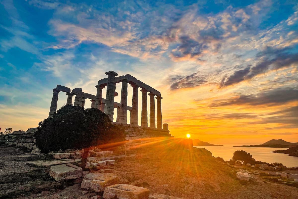
A Cape Sounion tour is a trip from Athens to the southern tip of Attica, where the Temple of Poseidon stands above the sea. The headland looks out over the Aegean. It is one of the Greece Tours on Greece Ville, listed with the other Athens tours and Greece shore excursions.
This post covers what a Cape Sounion tour is, how the temple rose and what its architecture shows. It also covers the names carved on the stones, the Temple of Athena Sounias and the ancient writers. The Laurion mines, the national park, the coast road, the sea, the best time of year and common questions come last.
The sections include Cape Sounion tours and related Athens day trips that can be booked online.
What is a Cape Sounion tour?
A Cape Sounion tour visits a rocky headland that rises almost straight up out of the sea. The Temple of Poseidon stands on an artificial terrace at its top. The cape also holds a sanctuary, a fortress wall, a settlement and a port.
A Cape Sounion tour crosses old ground. Early Bronze Age graves, from the 3rd millennium BC, have been reported on the cape. The ancient district of Sounion stretched between Lavrion, Megala Pefka, Kamariza and the cape.
In 1797 architects of the Dilettanti Society tried to draw and study the ruins. In 1829 the architect Blouet drew the ruins and partly dug out the gateway of the sanctuary. Work to restore the temple has gone on since 1875.
Walls about 400 m long on the north and east sides cut the cape off from the land. On a Cape Sounion tour, the wall is 3 to 3.5 m wide.
The ancient entrance gate stood in the northwest part of the wall and was reached from the port. Visitors on a Cape Sounion tour enter instead by crossing over the east part of the wall.
The sacred precinct that a Cape Sounion tour reaches sits on the highest ground of the fortress. It covers about 5000 square metres. A wall closes the precinct on every side except the steep south edge.
On a Cape Sounion tour, one street climbs the settlement from west to east. The exposed part is 100 m long and 3 to 3.60 m wide. Narrower streets cut the settlement into blocks of 30 by 30 m.
- Garrison: The settlement housed the soldiers on duty, and its layout suggests it was also the district centre.
- Port: The port lay in a sandy cove north of the fortress, sheltered from north winds.
- Beach: Trading ships were hauled onto the sandy beach.
The walls enclose about 4 hectares, with the sanctuary of Poseidon and a settlement inside. A cemetery of the Classical period lies near the church of Saint Peter. The cape belongs to Lavreotiki, a municipality with 25,199 residents in the 2021 census.


How did the Temple of Poseidon rise on a Cape Sounion tour?
A Cape Sounion tour reaches a temple that rose on an old sanctuary. In the 7th and 6th centuries BC, that sanctuary was busy but had no grand buildings. The new temple follows the size and plan of the older temple closely.
The marble for the new temple came from Agrileza, 4 km north of the cape. The quarries and the ancient road that carried the stone still survive in good condition. A Cape Sounion tour meets a temple of local stone.
The sanctuary on a Cape Sounion tour held more buildings. A two-aisle portico, or roofed porch, of the 5th century BC reused columns from the old Archaic temple. A banquet room for ritual feasts stood west of the gateway to the sanctuary.
Who designed the temple on a Cape Sounion tour? The scholar William Dinsmoor proposed that one architect designed four temples. They were the temples of Poseidon at Sounion, Hephaestus in Athens, Ares and Nemesis at Rhamnous. He nicknamed this builder the “Theseum architect”.
In Dinsmoor’s view, the builder worked between 449 and 432 BC. The Temple of Hephaestus, called the Hephaisteion, is one of the four. Scholars call its architect “the Hephaisteion Master”. No firm proof of his name exists.
On a Cape Sounion tour, the porch columns line up with the third column of the outer row. The Hephaisteion and the temple at Rhamnous share this trait. Historians link all three temples to one architect.
Large kouroi, statues of young men, stood on the cliffs from the end of the 7th century BC. The Sounion Kouros is one of the earliest examples of the kouros type. A kouros on the island of Samos stood more than 5 m high.
- Museum number: The Sounion Kouros carries inventory number 2720 in the National Archaeological Museum.
- Base: The base is 0.98 m long, 0.80 m wide and 0.248 m high.
- Pose: The young man stands with his left leg forward and his fists on his thighs.
When found, the statue lacked the lower right leg and the better part of the left leg. Pieces of other statues given to Poseidon, and a torso, lay with it. They were buried after the Persians destroyed the temple in 480 BC.
What does the architecture show on a Cape Sounion tour?
A Cape Sounion tour shows a Doric temple whose columns have 16 flutes, or upright grooves. The usual number is 20. The slim columns look almost like Ionic ones, another Greek style. The marble holds almost no iron, so it stays white.
One reading is that the architect chose 16 flutes to cut weathering on such an exposed site. On a Cape Sounion tour, the flutes meet in sharp ridges. Each ridge is called an arris.
A Greek Doric column has no base. Each column on a Cape Sounion tour stands straight on the platform called the stylobate. At Sounion, the stylobate measures 31.1 m by 13.4 m. The shafts are straight-edged, without the slight outward curve called entasis.
A Doric frieze, the band above the columns, alternates blocks called triglyphs and metopes. The triglyphs have two upright grooves and recall the ends of old wooden beams. On a Cape Sounion tour, the metopes were left smooth, with no carving.
Antefixes, decorative tiles at the roof edge, with a palmette (palm-leaf) design crowned the gable roof. The sloping edge of the gable has a pitch of 12.5 degrees instead of the usual 15 degrees.
A shallow Ionic frieze, a continuous band of carved scenes, decorated the beam over the porch. The slabs were cut from white marble from Paros. On a Cape Sounion tour, the surviving pieces are badly eroded.
Scholars believe the scenes included a battle between gods and giants. Fourteen carved panels from the temple have been found. Experts place the sanctuary’s treasures in the opisthodomos, the inner room at the back of the temple.
- Gateway: The sanctuary gateway had two Doric columns and three entrances, the middle one 2.2 m wide.
- Approach: Two flights of steps and a ramp led through the gateway.
- Four columns: In the late 1950s, four columns on the north side were raised again.
- Restorer: The Greek Archaeological Service, led by Anastasios Orlandos, gave the temple its present look in the 1950s.
On a Cape Sounion tour, the details add up. Sixteen flutes, smooth metopes and a worn Ionic frieze make the temple a Doric building with Ionic touches. The marble stays white.
Who carved names on the temple seen on a Cape Sounion tour?
A Cape Sounion tour reaches a temple whose stones are covered with etched marks. Known and unknown visitors have left them since ancient times. Poets, painters and a navy officer also recorded the place over the centuries, each in a different way.
A Cape Sounion tour visits a temple with fallen columns. Two wooden dowels from one fallen column carried the Greek letters ΕΥΘΥ and Ε. Navy captain Augustus Clifford gave stone column drums to his half brother, the Duke of Devonshire.
In the third canto of Byron’s Don Juan, a poet sings a song called “The Isles of Greece”. The last verse begins, “Place me on Sunium’s marbled steep”. There the singer asks to sing “swan-like” and die, with only the waves to hear him.
The last verse ends with the singer saying that a land of slaves will never be his. A Cape Sounion tour reaches the headland that this verse names. In a later canto, Byron writes that he ate olives and bread on Sunium or Hymettus.
William Pars painted a watercolour called “Temple of Poseidon at Sunium” in August 1765. He joined a trip paid for by the Society of Dilettanti. Richard Chandler and Nicholas Revett went with him.
Edward Dodwell drew a south-east view of the temple for his book Views in Greece. J. M. W. Turner painted it as “The Temple of Minerva Sunias, Cape Colonna”. A Cape Sounion tour reaches the temple that these artists drew.
J. T. Willmore engraved Turner’s picture in 1854 for members of an art society in Scotland. On 3 October 1852, George Pechell Mends, a warship’s first lieutenant, sketched the cape from the sea.
- Gulfs: The fort commanded the entrance to the Saronic and South Euboean gulfs and guarded southern Attica.
- Towers: A Cape Sounion tour passes its wall, which had small towers built 66 feet apart.
- Dating: Experts date the ship sheds to the 3rd century BC, when Macedonians held the fort.
A wooden structure in each shed protected a ship’s bottom. Wet hulls made a trireme (an old warship) heavy and slow, so dry hulls were vital. A Cape Sounion tour reaches the fort with these sheds.
What does the Temple of Athena Sounias show on a Cape Sounion tour?
A Cape Sounion tour shows only traces of the Temple of Athena Sounias. Foundations, column bases and a statue base remain. In ancient times the temple was taken apart down to its lowest foundation course. That course still lies in place.
Experts rebuilt the outer row of columns on paper. It had 10 columns without grooves on the east side and 12 on the south side. The Ionic style, known for scroll-topped columns, was uncommon in Attica then. A Cape Sounion tour reaches one of its earliest examples there.
The altar stood on the south side of the temple. That hints at a second doorway in the south wall. The Roman writer Vitruvius likened it to temples with a door in the middle of a long side.
Two Ionic capitals (carved column tops) of the temple are on show in the Agora Museum in Athens. They rank among the best-kept early Ionic capitals on the mainland. Paint still shows on them: palm-leaf patterns, a double meander (a winding line) and a scale pattern.
Builders reused pieces of the temple in the first half of the 2nd century AD. They made the Southeast Temple in the Athens Agora. A Cape Sounion tour sees where those pieces began.
The Southeast Temple stood in the south-east corner of the Agora. It had eight columns across its front and was 20.60 metres long. Its columns were 0.65 metres wide at the base and 5.974 metres tall in all.
Diggers in Athens found fifteen column drums (round stone blocks), one whole capital and twelve capital pieces. They came from the temple that a Cape Sounion tour reaches. The drums carry mason’s marks, letters such as Γ, Θ and Λ.
- Statue: On a Cape Sounion tour, the base of the cult statue still stands inside the main room.
- Roof: Four columns inside the main room held up the roof, and their bases survive.
- Tiles: Experts link the marble roof tiles to the island of Paros.
- Bases: The columns stood on plain disc-shaped bases with no decoration.
The Herulian sack of Athens in AD 267 damaged the Southeast Temple. Its stones went into a new city wall. A Cape Sounion tour shows what stayed behind at Sounion.
Which ancient writers tell of the cape on a Cape Sounion tour?
A Cape Sounion tour follows a coast that Homer, Herodotus, Thucydides, Pausanias and Strabo all wrote about. Their lines tell of storms, a feud with Aegina, a fort for corn ships and a mythical king. Each of them names the cape.
In the Odyssey, young Telemachus asks the old king Nestor where Menelaus was when Agamemnon was killed. Nestor answers that Apollo struck down Menelaus’s helmsman, Phrontis, with gentle arrows. A Cape Sounion tour reaches the cape of that tale.
At the steep height of Malea, Zeus sent shrill winds, and the waves swelled like mountains. The storm split Menelaus’s fleet. Part of it reached Crete, and five ships were carried to Egypt.
In Herodotus, an Aeginetan named Nicodromus, banished from his island, offers to betray Aegina to Athens. Corinth lent Athens twenty ships, because its law banned free gifts. Athens sailed with seventy ships in all.
When the Athenians failed to show up on the agreed day, Nicodromus took ship and fled Aegina. Athens gave him and the other Aeginetan exiles Sunium to live in. From there they raided Aegina. The cape that a Cape Sounion tour reaches thus joined this feud.
Thucydides says the Athenians fortified Sunium in one winter. The aim was to let their corn ships round it in safety. He adds that, with food arriving by sea round Sunium, Athens became a fortress, not a city.
Pausanias wrote Description of Greece in ten books, and his tour begins in Attica. He opens with the Sunium promontory. A Cape Sounion tour reaches it. It faces the Cyclades islands and the Aegean Sea.
- Strabo: He lists the coastal towns of Attica as far as the cape of Sunium.
- Leap: Legend says King Aegeus leapt from the cliffs of Sounion, thinking his son Theseus had died.
- Tribute: Athens had to send seven young men and seven young women to Minos every nine years.
Aegeus hid a sword, a shield and a sandal under a huge rock for his future son. Sophocles wrote a play called Aegeus, which is lost, and Aegeus appears in Euripides’ play Medea. A Cape Sounion tour reaches the cliffs of that legend.
What did the Laurion mines mean for a Cape Sounion tour?
A Cape Sounion tour passes old mining land. Lead from the Laurion mines went into Mycenaean objects. Thorikos shows lead mining from the 3rd millennium BC and silver mining from 1500 BC. Companies, a museum and a park came later.
A Cape Sounion tour can add Thorikos, a town of smiths. Its packed streets held smiths’ workshops from the 7th to the 4th century BC. Its oval theatre is about 55 m wide and held 2,000 to 3,200 people at its last stage.
Thorikos lies in the north of the Laurion mining region, near Francolimani Bay. Soureza lies in the south, near Mt Michaeli. A Ghent University study found Thorikos less productive than Soureza, as its cisterns got too little rain runoff.
A Cape Sounion tour can follow the ore from the ground to the furnace. Smelters heated the washed ore to very high heat to separate the lead from the silver. Lead, mercury, cinnabar, red chalk and ochre were by-products of silver.
The mines on a Cape Sounion tour shut and reopened more than once. The Peloponnesian War of 431-404 BC cost Athens free men and slaves, and the mines shut down. Around 370 BC, businessmen rented abandoned mines and did better than they expected.
The owl coins of Athens add to the mining story of a Cape Sounion tour. Athenians called their silver coins glaukes, or little owls. These coins turned up in Egypt, the Levant and the eastern Persian Empire.
In 1864 Giovanni Serpieri and partners won a government permit to run the mines. In the Lavreotika dispute, France and Italy demanded 20 million francs for the company. They threatened to send troops, and Greece changed its government five times in three years.
- Workers: By 1867 the company employed 1,200 workers, a record for Greece.
- Hours: Miners worked seven days a week, for 12 to 14 hours a day.
- Firsts: The Hellenic Company is tied to the first use of electricity and the telephone in Greece.
A Cape Sounion tour can end this story at the old smelting complex. It stopped work in 1989. The National Technical University of Athens then set out to turn it into a park. The Mineralogical Museum of Lavrion shows a small wagon from the Adami gallery.
What does the Sounion National Park show on a Cape Sounion tour?
A Cape Sounion tour passes close to the Sounion National Park. Its nature area carries the code GR3000005 in the European Natura network of protected places. Pine forests and low scrub cover the ground, and ancient mines lie inside the park.
The park covers the inland part of Lavreotiki, from Plaka to Sounio and Legrena. Its entrance lies 1 to 2 km from the Temple of Poseidon. A Cape Sounion tour therefore sits close to this woodland.
The Natura site of Sounio also takes in an islet and a coastal sea zone. Official European records put its size at about 5,386 hectares. Pine forests cover 1,137 hectares of it.
On a Cape Sounion tour, low scrub called phrygana covers more than 317 hectares of the Natura site. It grows on limestone soil near the sea, where the summers are dry. Typical plants are kermes oak, lavender, thyme and white cistus.
The Aleppo pine forest of the park was the biggest and best-kept pine forest in eastern Attica. Olive and carob forests cover 1,416 hectares of the Natura site. Two plants found only around here are Centaurea laureotica and Centaurea attica.
A Cape Sounion tour passes land where tortoises live. The Natura list for Sounio names Hermann’s tortoise and the marginated tortoise. The marginated tortoise is the largest tortoise in Europe. The list also names the nose-horned viper and the Balkan green lizard.
The Natura list for Sounio names three bats: the European free-tailed bat, Savi’s pipistrelle and Kuhl’s pipistrelle. Common birds such as owls live in the park, and migrating birds cross the whole area.
- Minerals: More than 260 minerals have been collected in the park area.
- Caves: Caves and rock forms trapped plants and animals, which left fossils.
- Fossils: The fossils include red deer and Spalax, a blind mole-rat, which no longer live in Attica.
- Mines: The park of a Cape Sounion tour holds large remains of ancient mines and workshops.
Kermes oak was once the food plant of kermes insects, which gave a red dye called crimson. A Cape Sounion tour can add this woodland to the temple visit. Pines, tortoises, bats, fossils and old mines share one area.
What lies along the coast road of a Cape Sounion tour?
A Cape Sounion tour follows the EO91, a coast road 68.1 km long from Athens to Sounion. Along it lie Saronida, Anavyssos, Palaia Fokaia and Legrena. These places hold ancient sites and a lake with its own wildlife.
In Athens, the EO91 meets the EO1, the EO54 and Vouliagmenis Avenue. A Cape Sounion tour then runs south through the municipality of Saronikos. It formed in 2011 from five former municipalities, among them Anavyssos and Saronida.
Public buses also serve this coast. City bus 122 runs from Argyroupoli metro station to Saronida. Bus 123 runs from Saronida through Anavyssos to Palaia Fokaia. At Lagonisi, the shipping billionaire Aristotle Onassis once had a villa.
Saronida had 3,424 residents in 2021, up from 733 in 1981. A Cape Sounion tour then reaches Anavyssos, which had 6,180 residents in 2021. Anavyssos lies 4 km east of Saronida and 10 km west of Lavrio.
The writer Elias Venezis set his 1939 novel Tranquility in Anavyssos, a stop on a Cape Sounion tour. Small settlements such as Agios Nikolaos, Mavro Lithari and Lakka belong to it. The ancient coastal district of Anaphlystus, part of ancient Athens, stood at Agios Georgios, close to Anavyssos.
The Kroisos Kouros from Anavyssos sits at the centre of a debate. Do kouroi show real young men or ideal warriors? The Getty kouros looks suspiciously like it, so experts debate whether the Getty kouros is genuine.
Lake Vouliagmeni, which a Cape Sounion tour can pass, reaches 29 degrees Celsius in summer. A 2004 study recorded 12 plants and 24 animals there for the first time. Only three kinds of fish were found, and one is a South American aquarium fish.
- Palaia Fokaia: It had 3,025 residents in 2021, and its unit covers 22.944 square kilometres.
- Thymari: This village of Palaia Fokaia had 515 residents.
- Distance: Palaia Fokaia lies 9 km west of Lavrio.
- Legrena: This village had 345 residents in 2021.
Scientists described the sea anemone of Lake Vouliagmeni as a new species in 1987. A Cape Sounion tour along this coast passes towns, an ancient district and a lake with wildlife.
What does the sea around a Cape Sounion tour show?
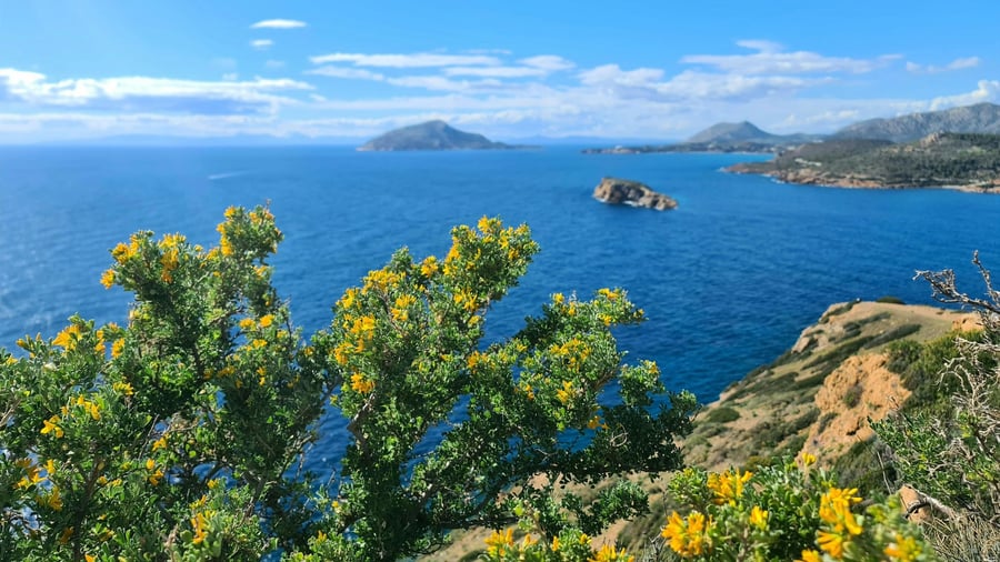
A Cape Sounion tour looks out over islands, a channel and wrecks on the sea floor. The Kea Channel lies between Kea and Makronisos, just off Cape Sounion. A small rocky islet called Archi lies directly below the Temple of Poseidon, west of the cape.
The sea off a Cape Sounion tour holds the island of Patroklos. It covers 2.787 km², and its largest sides measure 2.5 km and 1.5 km. The island rises 253 m above the sea. It lies 850 m from the mainland coast.
A Ptolemaic commander named Patroclus once worked across the waters of a Cape Sounion tour. He set up bases on Crete, Ceos, Thera, Attica and the Argolid. Ceos is the old name of Kea. On Kea, Patroclus made the town of Ioulis his headquarters.
The steamer Oria left Rhodes for Piraeus on 11 February 1944. It carried 4,116 Italian prisoners and sank off Cape Sounion. The Greek diver Aristotelis Zervoudis found the wreck in 1999. A Cape Sounion tour looks over that same water.
On a Cape Sounion tour, the name Makronisos means “Long Island” in Greek. It covers 20 km² and rises to 281 m. After 1922, it served as a quarantine station for Greek refugees, to stop smallpox and typhus from spreading. In 1922 and 1923, 12,295 refugees passed through.
On 21 November 1916, the hospital ship Britannic hit a German mine in the Kea Channel. It sank in 55 minutes, and 30 of the 1,066 people on board died. Jacques Cousteau found the wreck on 13 November 1975 with side-scan sonar. It lies about 122 m deep.
- Patris wreck: A steamship hit a reef off Kea on 24 February 1868 and lies 28 m deep.
- Kea size: Kea is 19 km long and 9 km wide, with an area of 128.9 km².
- Lion of Kea: The stone lion dates to at least 600 BC.
- Myrtoan Sea: This part of the Aegean lies south of Euboea, Attica and Argolis.
Makronisos was a prison island from 1947, and it has been protected since 1989. Ioulis, the capital of Kea, stands inland on high ground. Ancient Cycladic towns made that choice for fear of pirates. The sea of a Cape Sounion tour has a long record of exile and wreck.
When is the best time of year for a Cape Sounion tour?
A Cape Sounion tour meets hot, dry summers and mild winters. At Lavrio, the average high is 14.2 °C in January and 31.3 °C in July. At Sounio, December is the wettest month of the year, with 110.3 mm of rain.
July is the hottest month at Sounio, with an average high of 33.4 °C. August follows at 33.1 °C. Nights stay warm too, with an average low of 24.5 °C in both July and August. A Cape Sounion tour in midsummer meets heat by day and by night.
Summer is also dry. July is the driest month at Sounio, with 1.6 mm of rain, and August brings only 2.5 mm. Lavrio gets just 0.3 mm of rain in August, against 80.5 mm in December.
Spring warms fast at Sounio. The average high climbs from 20.1 °C in April to 25.4 °C a month later. Autumn cools slowly. Average highs are 29.1 °C in September, 24.9 °C in October and 20.4 °C in November. A Cape Sounion tour in these months meets warm days.
Winter highs at Sounio are mild, with 14.8 °C in January and 15.5 °C in February. The coolest nights come in February, with an average low of 8.2 °C. Rain rises from 40.0 mm in September to 62.8 mm in November.
Records on a Cape Sounion tour show the extremes. Lavrio has reached 42.4 °C, in July. At the coastal Elliniko station in Athens, the record high is 43.0 °C, set in August. The record low there is minus 4.2 °C, set in February.
- February sun: Elliniko gets 134.4 hours of sunshine.
- February rain: Elliniko has 11.4 rain days.
- Kea winter: The average January high on Kea is 11.7 °C.
The same pattern shows on Kea. A station at 192 m records 142.3 mm of rain in December and none in August. Rain falls in winter, and summer stays dry. A Cape Sounion tour follows that rhythm.
What do travelers want to know about a Cape Sounion tour?
A Cape Sounion tour raises six questions. They cover the temple, the god, the statues, the port, the poet and the name. The Romans knew Poseidon as Neptune. Kato Sounio, a village beside the cape, had 164 residents in the 2021 census.
How old is the temple on a Cape Sounion tour?
Scholars date the first cult centres of Athena and Poseidon on the cape to about 700 BC. Athens built the first big Poseidon temple there around 490 BC, as a large state project. It was never finished, because the Persians destroyed it. A small temple for worship was built soon after.
Who was Poseidon on a Cape Sounion tour?
Poseidon is one of the twelve Olympian gods, and the Greeks called him the tamer of horses. In Homer, the three sons of Cronus drew lots, and Poseidon won the sea. His name appears on Linear B clay tablets more times than the name of Zeus.
Where are the Sounion kouroi of a Cape Sounion tour kept?
Three colossal kouroi, or statues of young men, were found at Sounion. They are now kept in the National Archaeological Museum in Athens. The Sounion Kouros is carved from Naxos marble and dates to about 600 BC. After restoration, it stands 3.05 m tall. Red colour still shows in its braided hair.
Where does the port of Lavrio lie for a Cape Sounion tour?
Lavrio had 7,525 residents in the 2021 census. The town was built from scratch from 1865 on a planned grid, with palm trees lining its avenues. Kythnos lies 25 nautical miles, or 49 km, from its port. The municipality of Lavreotiki, formed in 2011, covers 175.798 km².
Why does Lord Byron matter to a Cape Sounion tour?
Lord Byron (1788 to 1824) was a British poet and a major figure of the Romantic movement. He studied at Trinity College, Cambridge, and lived for seven years in Italy. He joined the Greek War of Independence and died of a fever at Missolonghi in 1824, aged 36. Greeks honour him as a folk hero.
What was the ancient deme of Sounion on a Cape Sounion tour?
A deme was a local district of ancient Attica. In the 2nd century BC, the deme of Sounion belonged to the Attalid tribe, named for Attalus. A citizen of the deme was called a Sounieus. The ancient Greek name of the cape was Akron Sounion. The Romans wrote it as Sunium.