
Day trips from Nafplio start in the port town of the Argolid and reach Mycenae, Epidaurus, Tiryns, Argos, Lerna, ancient Corinth, Nemea, Mystras, Monemvasia and the Kynouria coast. The page is part of the Greece Tours on Greece Ville.
This page covers what day trips from Nafplio are, the town, Palamidi and Bourtzi, Mycenae, Epidaurus, Tiryns, Argos and Lerna, ancient Corinth, then Nemea, Mystras, Monemvasia and the east coast. Common questions come last. Each section links to the Greece Ville posts on single tours.
What are day trips from Nafplio and where do they lead?
Day trips from Nafplio are single-day journeys from the port town on the Argolic Gulf to nearby sites of the Argolid, such as Mycenae, Epidaurus, Tiryns, Argos and Corinth, all reached from one base in the north-east Peloponnese of Greece.
Nafplio is the capital of the regional unit of Argolis and an important tourist destination. It lies on the Argolic Gulf in the north-east Peloponnese, which puts the Argolid sites close by.
The Argolid Peninsula holds Mycenae, one of the first major Greek settlements. In the Classical age its main settlements were Troezen, Hermione and Epidaurus, so day trips from Nafplio cover old ground.
Mycenae lies 11 kilometres north of Argos and 48 kilometres south of Corinth. The sanctuary of Asclepius at Epidaurus stands about eight kilometres from the modern town of that name.
The name Epidaurus honours the hero Epidauros, son of Apollo. Strabo adds that the city was first called Epikaros under the Carians and Epitauros under the Ionians, before the Dorians gave the final form.
Nafplio itself served as the capital of the First Hellenic Republic and of the Kingdom of Greece until 1834. Day trips from Nafplio therefore pass from Bronze Age citadels to the early Greek state.
- Base: Nafplio is the capital of Argolis and the starting point of each route.
- Mycenae: The citadel lies 19 kilometres inland from the Saronic Gulf.
- Epidaurus: The city stood on the Argolid Peninsula by the Saronic Gulf.
- Corinth: The ancient city sat on the isthmus that joins the Peloponnese to mainland Greece.
Day trips from Nafplio follow one order below. The route starts in the town, runs through the Bronze Age sites of the plain and ends at Corinth on the isthmus.
Which sights in Nafplio town belong on day trips from Nafplio?
Day trips from Nafplio begin in the town itself, where the Acronauplia, the Venetian walls, the harbour and an archaeological museum record a port that Crusaders, Venetians, Ottomans and Greeks each fought to hold in a long run of sieges.
The Nafplio day trip post covers the town, its history, squares and food, while the Nafplio walking tour post covers the old town lanes, Akronafplia and the waterfront.
Crusaders besieged the port from 1205 to 1212, Venetians in 1686, Ottomans in 1715 and Greeks in 1821 and 1822. Russian and Ottoman fleets fought a Battle of Nauplia in 1770.
The Archaeological Museum of Nafplio holds finds from Franchthi Cave, excavated between 1967 and 1976. Its deposits begin about 20,000 BCE and end about 3000 BCE, the longest continuous sequence recorded at one site in Greece.
The cave records a move from hunting and gathering to farming. Neolithic layers yielded domesticated sheep, goats, wheat, barley and lentils, while Mesolithic obsidian came from Melos, about 150 kilometres away.
- Wine cooler: The museum shows a well preserved wine cooler from Tiryns, dated 2700 to 2200 BCE.
- Prime minister: Sotirios Sotiropoulos, a lawyer, became Prime Minister of Greece and is listed among the notable people of Nafplio.
- Writer: Angelos Terzakis, who lived from 1907 to 1979, is another notable person of the town.
- Museum: The collection covers southern Argolis, so it suits day trips from Nafplio.
Day trips from Nafplio can end where they began. The harbour town holds the museum, the walls and the record of each siege, which makes it the first stop before day trips from Nafplio head inland.
What do Palamidi and Bourtzi add to day trips from Nafplio?
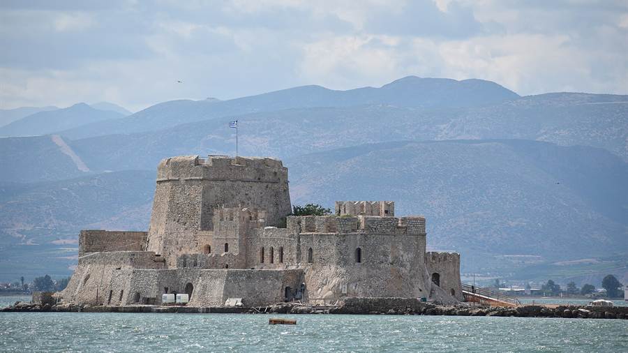
Day trips from Nafplio take in two Venetian strongholds: Palamidi, a baroque fortress on a hill above the town, and Bourtzi, a water castle in the harbour that was formerly called Kastelli and also Passaz, and both shaped the sieges.
During the Greek War of Independence, Nafplio was a major Ottoman stronghold and was besieged for more than a year. Starvation forced the surrender, and its strong fortifications made it the seat of the provisional government.
Palamidi has eight bastions. Six carry the names of ancient Greek leaders and heroes, and the other two honour Saint Andrew and Robert, a French philhellene who died in battle on the Acropolis of Athens.
In 1821 Greek soldiers seized Bourtzi and used it to bombard Nafplio. From the islet they also stopped an English ship from resupplying the besieged Turks, which shows its value in the siege.
Bourtzi stands in the middle of the harbour, and Palamidi rises to the east of the Acronauplia. The Acronauplia, the oldest part of the city, completes the trio of fortified sites on day trips from Nafplio.
- Palamidi: The fortress is a typical baroque design built by the Venetians in their second occupation.
- Bourtzi: The castle takes its name from an Ottoman Turkish word meaning tower.
- Acronauplia: Part of it served as a prison before a hotel complex was built there.
- Seat: The fortifications led the provisional government of Greece to settle in Nafplio.
Day trips from Nafplio therefore meet three layers of defence within the town: a hill fortress, a harbour castle and an old citadel. Each one links to the sieges of 1822 and the years before.
Why do day trips from Nafplio include Mycenae, the Lion Gate and the shaft graves?
Day trips from Nafplio reach Mycenae, the Bronze Age citadel behind the name of the Mycenaean age, where the Lion Gate marks the main entrance and Grave Circle A holds six shaft graves under stelae that once stood over royal burials.
The Mycenae Epidaurus day trip post covers the citadel, the royal tombs, the site museum and the theatre of Epidaurus together on one route, with the Lion Gate and shaft graves as the main sights.
The Lion Gate is the sole surviving monumental piece of Mycenaean sculpture. Its relief shows two lionesses whose separately made heads are missing, and day trips from Nafplio pass beneath it.
Christos Tsountas cleared much of the citadel from 1884 to 1902. The British School then dug there from 1920 to 1955 under Alan Wace, assisted by Winifred Lamb, and day trips from Nafplio follow that work.
In Greek myth Perseus founded Mycenae, and the Atreid kings followed. Tradition holds that Agamemnon sacrificed his daughter Iphigenia for a fair wind to Troy and that Clytemnestra slew him on his return.
- Heads: Scholars have suggested that the missing heads belonged to composite beasts such as sphinxes.
- Stelae: Three of the stelae over the shaft graves show chariot scenes.
- Tombs: After the last burial about 1500 BC, rulers turned from shaft graves to tholos tombs.
- Defeat: Troops from Argos captured Mycenae in 468 BC and razed its fortifications.
Mycenae commanded the easy routes to the Isthmus of Corinth, and day trips from Nafplio to the citadel pair well with Tiryns, Argos and Epidaurus.
What makes Epidaurus a core stop on day trips from Nafplio?
Day trips from Nafplio reach Epidaurus, where the sanctuary of Asclepius and its ancient theatre were inscribed on the UNESCO World Heritage List in 1988 because of their exceptional architecture, and where ancient drama is still staged in the summer.
The monument keeps the three-part layout of a Hellenistic theatre: theatron, orchestra and skene. Restoration has recovered it, apart from the stage building, almost entirely in its original form, which day trips from Nafplio show.
A corridor 1.82 metres wide separates the lower auditorium from the upper epitheatre. The stage building rose in two phases, in the late fourth century BC and the mid-second century BC.
The Archaeological Society began the first systematic excavation of the theatre in 1881. Restorations followed in 1907, from 1954 to 1963 and from 1988 to 2016 under the Preservation Committee for Epidaurus Monuments.
During the Achaean War in 146 BC the Achaians converted the sanctuary into a stronghold. After the Roman general Lucius Mummius destroyed Corinth that year, he visited the sanctuary and left two dedications there.
- Serpents: Pausanias wrote that yellowish serpents were sacred to Asclepius and tame with men.
- Grove: Pausanias recorded that no death or birth took place within the enclosure of the sacred grove.
- Town theatre: A second theatre in the town of Epidaurus belongs to a scheme that has mapped 140 ancient arenas across Greece.
- Setting: The theatre stands on the west side of Cynortion Mountain, near modern Lygourio.
The Epidaurus Festival continues today and runs through the summer months, which makes the theatre a fixed point among day trips from Nafplio.
How do the Cyclopean walls of Tiryns fit into day trips from Nafplio?
Day trips from Nafplio include Tiryns, the Mycenaean hill fort whose Cyclopean walls still stand 7 metres high in places, built from huge limestone boulders that classical Greeks thought only the one-eyed Cyclopes had the strength to move.
At Tiryns the walls cover the whole top of the hill. Their original height is estimated at 9 to 10 metres, and they are about 6 metres thick, reaching 17 metres where tunnels pass through.
In the second phase the gate copied the Lion Gate of Mycenae. A tower and a wall arm forced attackers through a narrow corridor, a layout met on day trips from Nafplio.
Heinrich Schliemann tested the site in August 1876 and took the palace for a medieval building, so he came close to destroying the remains. He came back in 1884, and the ruins were read correctly later by Wilhelm Dörpfeld.
Tiryns lost importance in the Classical period. Slaves held it for years after Cleomenes I of Sparta defeated the Argives, according to Herodotus, and Tiryns sent 400 hoplites to the Battle of Plataea.
- Phases: The acropolis was built in three phases, the last at the end of Late Helladic IIIB.
- Entrance: The citadel entrance was always on the east side, though its form changed in each phase.
- Temple: A Doric temple rose in the ruins of the burned palace during the Geometric period.
- Early ring: An imposing circular structure, 28 metres across, stood on the hill in the third millennium BC.
Tiryns lies south of Mycenae, so day trips from Nafplio can pair the two citadels and compare their Cyclopean walls.
What do Argos and Lerna add to day trips from Nafplio?
Day trips from Nafplio reach Argos, the largest city in Argolis, and Lerna, the marshy spring site to the south that Greek myth names as the lair of the Lernaean Hydra, joining a long civic story with a prehistoric mound.
Argos was a democracy through the classical period, apart from a brief break between 418 and 416 BC. Its Assembly was the aliaia, its Council the bola, and magistrates served six-month terms.
King Pyrrhus of Epirus was killed in the streets of Argos in 272 BC. According to Plutarch, a tile thrown from a rooftop by an old woman knocked him off his horse.
In 1821 the Consulate of Argos was proclaimed on 28 March under Stamatellos Antonopoulos. Later, supporters named Argos a candidate to replace Nafplio as capital, but Ludwig insisted on Athens.
Lerna was a region of springs and a former lake near the east coast of the Peloponnese. Its site at Mili lies on a narrow point between mountains and sea, on an ancient route south.
- Rite: Plutarch records that Dionysus was summoned at Lerna as Bugenes, with a trumpet called the salpinx.
- Lake: The last remnants of the marsh that replaced the lake were drained in the nineteenth century.
- Mound: Lerna’s mound, about 180 by 160 metres, is one of the largest prehistoric tumuli in Greece.
- Abandonment: In the Mycenaean age Lerna became a cemetery, and the site was abandoned about 1250 BCE.
Argos and Lerna sit between Nafplio and the Bronze Age citadels, so day trips from Nafplio pass both on the way to the plain and back.
Why do ancient Corinth and Acrocorinth belong on day trips from Nafplio?
Day trips from Nafplio end at the Isthmus of Corinth, where the city of ancient Corinth lay below Acrocorinth, a monolithic rock that served as a last line of defence in southern Greece and commanded the land entry to the Peloponnese.
The Ancient Corinth tour post covers the temple of Apollo, the work of the apostle Paul, Acrocorinth, the trade of the city and the dig of the lower town.
George Forrest ranked Acrocorinth first among the acropoleis of mainland Greece. It was occupied from archaic times to the early nineteenth century, and a secure water supply helped it hold out.
The American School’s Corinth Excavations began work on Acrocorinth in 1929. The site now ranks as a leading medieval castle site of Greece, which suits day trips from Nafplio.
In 395 BC the Corinthian War set Corinth, Thebes, Athens and Argos against Sparta. In 392 BC Argives faced Spartans at the Long Walls of Corinth, an example Aristotle used for facing danger with knowledge.
- Horace: The poet Horace is quoted as saying that not everyone is able to go to Corinth.
- Distance: The modern city lies about 5 kilometres north-east of the ancient ruins.
- Alexander: A governor’s son, Alexander of Corinth, sought independence as a tyrant in 253 or 252 BC.
- Retaken: Antigonus II Gonatas retook the city in the winter of 245 or 244 BC.
Corinth closes the loop of day trips from Nafplio: the route begins at a Venetian harbour and ends at a rock fortress that held the road into the Peloponnese.
Which Corinth Canal stop belongs on day trips from Nafplio?
Day trips from Nafplio reach the Corinth Canal by heading north across the Argolid to the isthmus. The sea-level cutting joins the Gulf of Corinth to the Saronic Gulf, has no locks, and separates the Peloponnese peninsula from the Greek mainland.
The Corinth Canal tour post covers the cutting, its bridges and the ships that pass. This section adds the history of the unstable walls, which shaped how the canal worked after its opening.
The canal opened formally in July 1893. It did not open to navigation until November 1894, because landslides blocked the cutting. Repairs to the walls between 1893 and 1940 closed it for four years in total.
In 1923 alone, 41,000 cubic metres of material fell into the canal, and clearing it took two years. High walls also funnel wind along the channel, which complicates navigation.
On 26 April 1941, German parachutists and glider troops attacked the main bridge during the Battle of Greece. They captured it, but British demolition charges destroyed the structure.
After the war, the United States Army Corps of Engineers began clearing the canal in November 1947. It reopened to shallow-draft traffic by 7 July 1948 and to all traffic that September.
- Traffic: Around 15,000 ships a year use the waterway, an average of about 40 a day.
- Craft: Large vessels struggle in the narrow channel, so smaller recreational boats are the main users.
- Closure: A landslide closed the canal at the beginning of 2021.
- Reopening: The canal reopened to ships on 1 June 2023 after further safety measures.
Day trips from Nafplio that pause at the isthmus therefore see a waterway shaped by landslides, war damage and repair, as much as by the ships that use it today.
What do day trips from Nafplio show at Nemea?
Day trips from Nafplio reach Nemea, home to an ancient sanctuary of Zeus, lies in the north-east Peloponnese and hosted one of the four Panhellenic Games. The nearby Nemea valley now holds the leading red wine appellation of southern Greece.
The Nemea wine tour post covers the vineyards, the Agiorgitiko grape and the ruins of the sanctuary. This section adds the races and contests of the ancient games.
The Nemean Games were one of the four Panhellenic Games of Ancient Greece. They were held every two years in July, and the programme mixed foot races, combat sports and horse events.
The stadion was a foot race of about 178 metres at Nemea. The diaulos doubled that distance, and the hippios doubled it again to about 710 metres. The dolichos was a long race.
In the pyx, a boxing-like contest, fighters bound their hands with long leather strips, and a knockout or surrender ended the bout. In the pale, wrestlers tried to throw an opponent to the ground three times.
The pentathlon combined the stadion, wrestling, javelin throwing, discus throwing and the long jump. Day trips from Nafplio that stop at the site see the stadium where such events ran.
- Basin: The Nemea basin lies at about 300 metres, and the mountains around it reach about 750 metres.
- Climate: The soil, altitude and climate of the basin suit viticulture.
- Ripening: Agiorgitiko ripens late, after mid-September.
- Planting: Growers plant the vines densely in poor soils to limit yields.
Day trips from Nafplio to Nemea therefore join two strands: a festival of races and contests held in July, and a red grape that grows on the valley floor.
Why do day trips from Nafplio continue to Mystras and Sparta?
Day trips from Nafplio continue south-west to Mystras, a fortified town in the Taygetus range above ancient Sparta. The town clings to a steep slope, and modern Sparta stands in the Evrotas valley on the ancient site.
The Mystras tour post covers the castle, the palace and the churches of the hillside. This section adds the town plan and the story of Sparta in the valley.
The slope made wheeled vehicles impractical at Mystras, so its streets were largely footpaths. Markets seem to have stood outside the city walls, on the flatter ground beyond the gates.
The end came in 1825, during the Greek War of Independence, when Egyptians under Ibrahim massacred the local population and destroyed the area. In 1831 the town was rebuilt under the name Sparta, 9 km away.
The ancient state was known as Lacedaemon, while Sparta referred to its capital, a group of villages in the Evrotas valley. Helots, the state-owned enslaved locals, formed the vast majority of the population.
The Visigothic king Alaric sacked Sparta in 396 AD, and much of its population later moved to nearby Mystras. Day trips from Nafplio therefore meet two settlements that took turns as the centre of Laconia.
- Municipality: The municipality of Sparta was formed on 21 March 1835 and officially declared in 1845.
- Streets: Modern Sparta has large squares and wide streets lined with trees.
- East: The Parnonas range rises east of the city, forested with Greek fir and other conifers.
- West: Mount Taygetos stands to the south-west of the city.
Day trips from Nafplio that include Mystras and Sparta therefore link a medieval hill town with the plain city that replaced it in the nineteenth century. The Sparta day trip post covers the Menelaion, Vapheio and the sanctuary of Artemis Orthia.
Why do day trips from Nafplio include Monemvasia?
Day trips from Nafplio include Monemvasia, a walled town on an island off the eastern coast of the Peloponnese. A sandy isthmus joins the rock to the mainland, and the old town keeps the Byzantine churches and walls of a former trading centre.
The Monemvasia tour post covers the rock, the lower town and the fortress above it. This section adds the later history of the town under Venetian and Ottoman rule.
Francesco Morosini occupied the whole Peloponnese in the Sixth Ottoman-Venetian War except Monemvasia, which resisted. He bombarded it in 1687, but the Turkish defenders refused to surrender and he withdrew.
In 1715 the Ottoman fleet arrived on 3 August and demanded surrender. The council asked for an extension to learn the Venetian fleet’s intentions. That fleet did not approach, and the city surrendered on 7 September 1715.
The 1828 census found just 659 inhabitants, because the war had destroyed the larger share of the houses. Monemvasia stayed the seat of the province until 1864, when the seat moved to Molaoi.
In 1951 the community counted 522 residents: 261 in Gefyra, 178 in the old town and 83 in Agia Kyriaki. Day trips from Nafplio now find an old town that fell to 32 residents by 1971.
- Name: The Italian form of the name, Malvasia, gave its name to the wine of that name.
- Sea route: The town grew into a commercial centre on sea routes such as the one to Sicily.
- Raids: The Arabs settled in Crete, and raids that had begun in the 9th century multiplied after that.
- Strabo: Strabo mentions the site as a Minoan fortress.
Day trips from Nafplio to Monemvasia therefore cover a long arc, from a medieval trading port to a village that nearly emptied in the twentieth century.
What do day trips from Nafplio find around Ermioni and Porto Heli?
Day trips from Nafplio follow the coast south-east to Ermioni and Porto Cheli, towns of the Ermionida municipality on the Argolid Peninsula. The municipality covers 421 square kilometres, and ancient ports and legends of Troezen lie along the same shore.
The Ermioni boat trip post covers the boat formats from the harbour and the islands off this coast. This section adds the history of the ports and towns on the shore.
Halieis was a port town at the mouth of the Argolic Gulf, and its people took their name from their fisheries. Its site lies near the modern Porto Cheli. Xenophon calls it autonomous after the Peloponnesian War.
The people of Tiryns and Hermione took refuge at Halieis when the Argives expelled them. Day trips from Nafplio therefore pass a coast that sheltered exiles from the cities of the plain.
Kranidi, in the same municipality, was one of the centres of the Greek uprising of 1777. After the revolt failed, locals abandoned the area to avoid persecution by the Ottomans.
Troezen stands on the Argolid Peninsula, facing Athens across the Saronic Gulf. A cult formed there around Hippolytus, and local girls traditionally dedicated a lock of hair to him before marriage.
- Formation: The Ermionida municipality was formed in 2011 from the units of Ermioni and Kranidi.
- Province: The province of Ermionida was abolished in 2006.
- Salamis: Before the Battle of Salamis in 480 BC, Athenian women and children were sent to Troezen for safety.
- Stele: A stele found at Troezen in 1959 carries the decree to evacuate Athens, in a later copy.
Day trips from Nafplio along this shore therefore join fishing ports, exile, revolt and the legends of Troezen in one short stretch of coast.
Why do day trips from Nafplio turn to Leonidio and the Kynouria coast?
Day trips from Nafplio head up the eastern coast of the Peloponnese to Leonidio, a town on a fertile plain under the Parnon range. Leonidio is the seat of South Kynouria, a municipality in Arcadia of 592 square kilometres.
Leonidio has 3,826 residents and sits between two steep mountainsides that enclose it from the north and south. The River Dafnon crosses the town, and three bridges link its banks.
Plaka is the port of Leonidio, 4 km from the town. It works mainly through tourism, with a small fishing fleet and taverns and bars next to the sea.
Leonidio stands near the ancient city of Prasiae, a harbour that mattered to Sparta until the Athenians ruined it in the Peloponnesian War. Day trips from Nafplio thus reach a coast that Sparta once used.
Agriculture remains a main source of income, and the plain grows citrus fruit, pears, tomatoes and olives. Three old windmills overlook the town. The writer Dimitrios Psathas advised spending Easter in Leonidio.
- Status: The Tsakonian region is not a formally defined political entity of the modern Greek state.
- Costakis: In 1951 Thanasis Costakis defined Tsakonia as the area from Agios Andreas south to Leonidio and Tyros.
- Municipality: South Kynouria was formed in 2011 from the units of Kosmas, Leonidio and Tyros.
- Sport: The Leonidio football club, founded in 1969, runs football and basketball departments.
Day trips from Nafplio to Leonidio therefore add a quieter east-coast stop, where plain, port and mountain sit close together and the Tsakonian region has its centre.
What do travellers ask about day trips from Nafplio?
Day trips from Nafplio travel in four directions: north to the Corinth Canal and Nemea, south-west to Mystras and Sparta, south to Monemvasia, and south-east along the Argolid coast. Each direction rests on documented history, from the canal to Leonidio.
What do day trips from Nafplio show at the Corinth Canal?
Day trips from Nafplio show a sea-level cutting without locks that joins the Gulf of Corinth to the Saronic Gulf. Landslides delayed its opening to navigation until November 1894, and a landslide closed it again at the beginning of 2021 before it reopened on 1 June 2023.
Which grape do day trips from Nafplio meet at Nemea?
Day trips from Nafplio meet Agiorgitiko at Nemea, a red grape that ripens late, after mid-September. Growers plant it densely in poor soils to limit yields, and the basin sits at about 300 metres with mountains around it reaching about 750 metres.
Why do day trips from Nafplio pair Mystras with Sparta?
Day trips from Nafplio pair Mystras with Sparta because the two share a valley and a history. The Visigothic king Alaric sacked Sparta in 396 AD, much of its population moved to Mystras, and after the town fell in 1825 Sparta was rebuilt 9 km away in 1831.
What does Monemvasia add to day trips from Nafplio?
Monemvasia adds a walled town on a tied island to day trips from Nafplio. The Italian form of its name, Malvasia, gave its name to a wine, and the old town fell from 178 residents in 1951 to just 32 residents by 1971.