
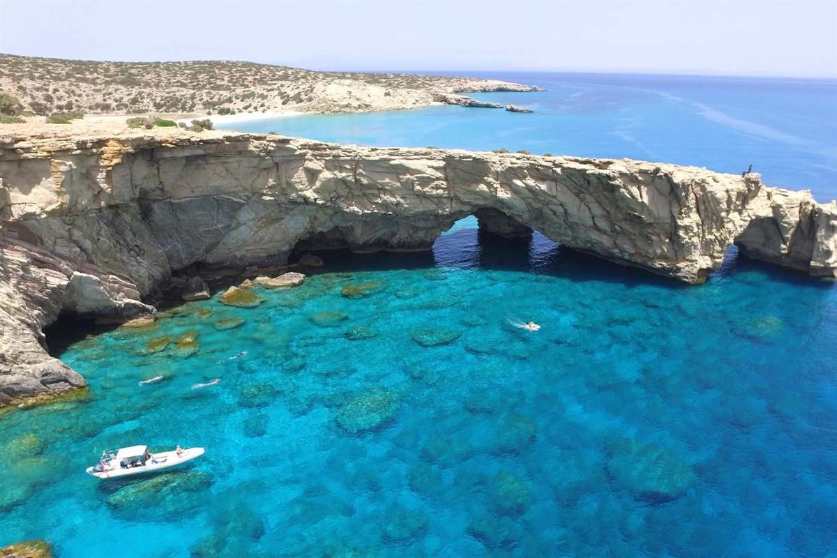
A Gavdos boat trip crosses the Libyan Sea from Chora Sfakion on the south coast of Crete to Gavdos, the island at the southern edge of Europe, with stops at its beaches and its rock arches. The trip is one of the Greece Tours on Greece Ville, listed with the other Crete tours and day trips from Chania.
This post covers the formats on sale, where Gavdos lies, the harbour of Chora Sfakion, Tripiti, Gavdopoula, the open sea, the beaches, the Calypso tradition, the history of the island, its nature, its villages and the questions that come up before booking.
What is a Gavdos boat trip?
A Gavdos boat trip is a sea crossing from Chora Sfakion, a small town on the south coast of Crete, to Gavdos, the southernmost Greek island. The route runs 26 nautical miles south across the Libyan Sea to the island.
The crossing starts in Sfakia, a mountainous area in the south-western part of Crete, within the regional unit of Chania. Boats head south from Chora Sfakion, with the White Mountains standing to the north.
On Gavdos, the largest man-made harbour is at Karave, where ferries from Crete dock. Ferry links join Karave with Paleochora, Sougia and Agia Roumeli on the south coast of Crete.
Gavdos has only a small number of year-round residents, and services for tourists remain basic. A Gavdos boat trip therefore lands visitors on a lightly settled island rather than at a large resort.
Buses connect the main locations on the island, and a heliport stands in its northern part. The road network is a mixture of paved, unsurfaced and dirt roads across the triangular island.
The format on sale from Chora Sfakion pairs the crossing with four beach stops. That format is the only one that sails to Gavdos itself; the others keep to the south coast of Crete.
- Start: Chora Sfakion, a small town on the south coast of Crete.
- Distance: Gavdos lies 26 nautical miles, or 48 km, south of Chora Sfakion.
- Sea: The route crosses the Libyan Sea, the stretch of the Mediterranean south of Crete.
- Arrival: Karave holds the largest man-made harbour on Gavdos.
The sections below trace a Gavdos boat trip from the harbour at Chora Sfakion to the cape at the southern tip of Gavdos and the open sea around it.


Which Gavdos boat trip formats are on sale?
A Gavdos boat trip is on sale in one format that sails from Chora Sfakion to Gavdos with four beach stops. The other listed formats are south-coast boat trips from the same harbour area, aimed at Loutro and nearby beaches.
The Gavdos boat trip format starts at the harbour of Chora Sfakion and crosses the Libyan Sea to the island. Its listing builds four beach stops into the outing before the boat returns to Crete.
A second format from the same town is a private boat hire for one group. Its listing names remote beaches as the target, reached by sea from the harbour that also serves the Gavdos crossing.
Two formats start in Chania, on the far side of the White Mountains. One reaches the car-free village of Loutro by boat and adds the south coast. The other markets Loutro as the Cretan Santorini.
A further format collects passengers in Scaleta, Rethymno and Kavros. It heads for Loutro and Sweet Water beach, two names that recur across the south-coast listings tied to Chora Sfakion.
A second catalogue adds two more listings. One links Chora Sfakion, Sweet Water and Loutro village in an outing across the south of Crete. The other is a Loutro trip that starts from Chania.
- Island crossing: One format sails from Chora Sfakion to Gavdos with four beach stops.
- Private hire: A boat from Chora Sfakion takes one group to remote beaches.
- Loutro runs: Formats from Chania, Rethymno, Scaleta and Kavros head for Loutro.
- Sweet Water: Two listings pair Loutro with Sweet Water beach.
The tour cards and availability boxes on this page list live dates for each Gavdos boat trip format, from the island crossing to the Loutro runs.
Where is Gavdos on a Gavdos boat trip?
A Gavdos boat trip ends at the southernmost island of Greece and of all Europe. Gavdos lies in the Libyan Sea, 48 km south of Chora Sfakion, covers 32.424 square kilometres with Gavdopoula and had 142 residents in 2021.
The island at the end of a Gavdos boat trip is part of Crete in administrative terms and sits in the regional unit of Chania. With the islets around it, Gavdos forms a single community.
Gavdos was part of Selino, a former province in the remote south-western corner of Crete. The province matched the present municipalities of Kantanos-Selino and Gavdos, and it was abolished in 2006.
The island has a roughly triangular shape. Its highest point is Mount Vardia, at 345 metres, or 1,132 feet, and the Mediterranean surrounds the island in every direction.
Year-round life on Gavdos is small in scale. The 2021 figure of 142 residents contrasts with summer totals that can pass 3,500 people, and campers and tourists make up the bulk of that seasonal crowd.
The southern position shows in the weather. Winters on Gavdos stay extremely mild by European standards, and January, the coldest month, averages around 14 °C. The island falls in plant hardiness zone 11a.
- Rank: Gavdos is the southernmost island in Greece and in Europe.
- Area: The municipality covers 32.424 square kilometres, Gavdopoula included.
- Height: Mount Vardia reaches 345 metres above sea level.
- Summer: The total on the island can pass 3,500 people in the summer season.
These figures frame a Gavdos boat trip: a crossing to a small, thinly settled island at the southern edge of Greece, administered from Crete.
How does a Gavdos boat trip leave Chora Sfakion?
A Gavdos boat trip leaves from Chora Sfakion, a small town and the capital of the remote and mountainous Sfakia region on the south coast of Crete. The town has two small harbours and lies 74 km south of Chania.
Chora Sfakion had just 322 inhabitants at the 2021 census. Its main harbourfront holds tavernas, two minimarkets, a butcher shop and a bakery, and a quiet local beach lies beside the west side of the village.
Tourism, fishing, olive oil production and the herding of sheep and goats drive the local economy. Rooms, studios and apartments give visitors a base in town before a Gavdos boat trip sets out.
The road from Chania crosses Crete from north to south through the village of Vryses. It then crosses the White Mountains, or Lefka Ori, passing the fertile Askifou plateau halfway between Vryses and the coast.
The town prospered under Venetian and Ottoman rule and traded with its own small fleet up to the 18th century. It reportedly had a hundred churches, but suffered from bombardment in the Battle of Crete.
The Sfakia municipality covers 467.589 square kilometres and had 2,002 inhabitants in 2021. Its coastal villages lack a linking coastal road, so ferry boats reach them along the shore.
- Harbours: Two small harbours serve the town on the Libyan Sea.
- Position: Chora Sfakion sits at 35°12′N 24°08′E, below the White Mountains.
- Name: The prevailing theory ties Sfakia to the ancient Greek word for a land chasm or gorge.
- 1941: After the Battle of Crete, locals helped Australian and New Zealand soldiers escape from Sfakia and suffered heavy reprisals.
Visitors planning more time in Sfakia can read about the Imbros gorge hike alongside a Gavdos boat trip from the same harbour town.
What is Tripiti on a Gavdos boat trip?
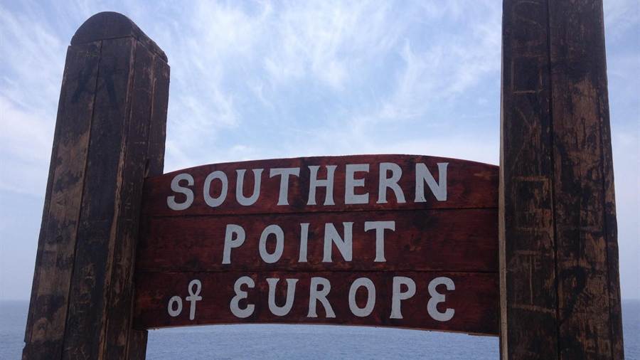
A Gavdos boat trip leads to an island whose south-eastern corner is Tripiti, a rocky peninsula with a natural arch carved by the elements. Cape Trypiti, at 34°48′N, marks the southernmost point of Greece and of Europe.
The name also appears as Trypiti, and the same place name turns up elsewhere in Greece. Tripiti is an archaeological site on Crete, and Trypiti is a village on Milos.
Visitors on a Gavdos boat trip who reach Trypiti find a concrete sculpture of an oversized chair on top. A group of Russians who came to the island in the 1990s built it.
A natural arch is a landform with an opening underneath. On coasts, arches form where cliffs or stacks face erosion from the sea or weathering, and erosion continues until the arch collapses.
Cape Trypiti sits at 34°48′03″N 24°07′20″E, south of every other point in Greece. The southern tip of the Greek mainland, Cape Tenaro, lies at 37°23′08″N.
When Greece won its liberation in 1830, the southern extreme of the state lay further north, at Eschati, or Mermengas, islet in the Cyclades, around 10 miles south-west of Santorini.
- Landform: A rocky peninsula with a natural arch at the south-eastern corner of Gavdos.
- Position: 34°48′03″N 24°07′20″E, the southernmost point of Greece.
- Landmark: A concrete chair sculpture stands on top of the cape.
- Mainland Europe: Punta de Tarifa in Spain marks the southern tip of the continental mainland, at 36°00′N.
Tripiti marks the southern limit of the island that a Gavdos boat trip reaches, the final cape of Greece facing the open Libyan Sea.
What is Gavdopoula on a Gavdos boat trip?
A Gavdos boat trip crosses the same stretch of the Libyan Sea that holds Gavdopoula, a Greek islet northwest of Gavdos and south of Crete. The islet belongs to the municipality of Gavdos and is a protected nature reserve.
The Gavdos municipality that a Gavdos boat trip reaches also includes Gavdopoula, within the regional unit of Chania. The municipal total of 32.424 square kilometres includes the islet, and both belonged to Selino Province.
Low-lying shrubs called phrygana cover the islet. The Greek term names a type of low scrubland, also known as garrigue, found on limestone soils around the Mediterranean Basin and near the coast.
As a plant community, phrygana is open scrub with wide gaps between bushes. Aromatic, lime-tolerant shrubs such as lavender, sage, rosemary and wild thyme are common across such scrub.
Gavdopoula is an important stop for migrating birds. BirdLife International has designated it, together with Gavdos, as an Important Bird Area, a site judged globally important for the conservation of bird populations.
In 1998 the islet was the proposed site of a large container shipping storage facility. Environmentalists campaigned against the plan and blocked it, and the islet gained protection as a nature reserve.
- Position: North-west of Gavdos and south of Crete, in the Libyan Sea.
- Cover: Low-lying phrygana shrubs spread across the islet.
- Status: BirdLife International lists the islet within an Important Bird Area.
- 1998 plan: A container shipping storage site was proposed and then blocked.
Gavdopoula adds a protected islet to the map of a Gavdos boat trip, and it shows that the Gavdos municipality spans more than one island.
What does the Libyan Sea show on a Gavdos boat trip?
A Gavdos boat trip crosses the Libyan Sea, the part of the Mediterranean south of Crete that geographers in antiquity named after the region of Libya. The south coast of Sfakia borders this sea, where dolphins and even whales are sometimes seen.
The name predates the modern state of Libya. In antiquity, Libya covered much of North Africa west of the Nile, and the Latin name Mare Libycum applied to the sea between Cyrene and Alexandria.
The stretch crossed on a Gavdos boat trip has recently gained a second name, the South Cretan Sea. The southern coastline of Crete that borders it includes the Asterousia Mountains and the Mesara Plain.
The Levantine Sea reaches its greatest depth of 4,384 metres in the Pliny Trench, about 80 km south of Crete. It covers 320,000 square kilometres, with Cyprus as its largest island.
Around Gavdos, the Mediterranean acts as a thermal regulator on every side. In summer the sea holds a high temperature, passing 26 °C, and hot winds from the Sahara Desert add to the mild climate.
Along the Sfakia coast the fish population is shrinking. On the Sfakia shore, rocky beaches face the sea and the White Mountains rise to the north, a combination that helped locals fight off invaders.
- Name: Ancient geographers used the Latin form Mare Libycum.
- Neighbours: The Levantine Sea lies to the east and the Ionian Sea to the north.
- Sea warmth: Summer sea temperatures around Gavdos pass 26 °C.
- Coast: Frangokastello, a Venetian castle built in 1371 to 1374, stands about 12 km east of Chora Sfakion.
Visitors pairing the sea crossing with a walk on land can set a Gavdos boat trip beside the Samaria gorge tour in western Crete.
Which beaches does a Gavdos boat trip reach?
A Gavdos boat trip reaches a coast with two beaches named in the island’s records, Sarakiniko and Korfos. Sarakiniko takes its name from the Saracens, while Korfos lies within the Fokia area, one of the main populated places on Gavdos.
Sarakiniko means “of the Saracens”. The name is the one surviving reference to Saracens on Gavdos, and the area around the beach also counts among the island’s main populated places today.
Korfos beach belongs to the Fokia area. Fokia is a populated district, so a Gavdos boat trip that stops at Korfos lands beside a settled part of the island rather than an empty shore.
The water around these beaches is the Libyan Sea. Ancient geographers called it Mare Libycum, and the name predates the modern state of Libya. The same waters now also carry the name South Cretan Sea.
Summer fills the beach areas. The total number of people on Gavdos can pass 3,500 in that season, and campers and tourists make up the bulk of the crowd on the sand.
Getting between beaches also happens on land. The road network on Gavdos mixes paved, unsurfaced and dirt roads, and bus services connect the main locations of the island.
- Sea daffodil: This bulb grows on Mediterranean beaches and coastal dunes, with much of its leaves buried in the sand.
- Flowering: The sea daffodil blooms from August to October, with white flowers carried in an umbel.
- Turtles: Greece is the top loggerhead nesting site along the Mediterranean, with more than 3,000 nests each year.
- Hatchlings: Coastal lighting and housing can disorient loggerhead hatchlings as they emerge from the nest.
On a Gavdos boat trip, each beach stop connects to a piece of the island’s story, from the Saracen name of Sarakiniko to the settled Fokia district around Korfos.
Why is a Gavdos boat trip linked to Calypso?
A Gavdos boat trip is linked to Calypso because Gavdos has been identified as a possible site of Ogygia. In Greek myth, Ogygia is the island where the nymph Calypso held Odysseus, as told in Homer’s Odyssey.
Homer mentions Ogygia in Book V of the Odyssey. In the poem, Calypso, the daughter of the Titan Atlas, detains Odysseus there for seven years and keeps him from his home on Ithaca.
Her name comes from the Greek verb kalypto, meaning to cover, to conceal or to hide. It translates as “she who conceals”, and the medieval Etymologicum Magnum reads it as “concealing the knowledge”.
The poem ends the stay through the gods. Athena complains to Zeus, who sends the messenger Hermes to order the release. Calypso then gives Odysseus an axe, a drill and an adze to build a boat.
Homer describes the island in detail. A fire burns in the hearth, and the scent of cleft cedar and juniper spreads over the isle. Alder, poplar and cypress grow in a wood around her cave.
Gavdos is not the only candidate. A tradition begun by Euhemerus in the late 4th century BC places Ogygia on Gozo in Malta, while modern Greek tradition points to Othonoi in the Ionian Islands.
- Birds in the poem: Owls, falcons and sea-crows nest in the wood that surrounds the cave.
- Springs: Four fountains flow with bright water in a row beside one another.
- Meadows: Soft meadows of violets and parsley bloom around the cave.
- Other theories: Victor Bérard named Perejil as Ogygia, and Strabo placed it in the Atlantic Ocean.
Tradition holds the Calypso link as one possibility among others, and a Gavdos boat trip presents it that way, beside Gozo, Othonoi and the other places named as Ogygia.
What history does a Gavdos boat trip touch?
A Gavdos boat trip touches a past that runs from Neolithic settlement to the Cauda episode in the Acts of the Apostles, then through Byzantine, Venetian and Ottoman rule, and on to the island’s use as a place of exile.
Gavdos has held a permanent population since Neolithic times and the Bronze Age. Archaeological evidence shows Roman activity, and the ancient principal town, Caudus or Kaudos, is tentatively placed near modern Agios Ioannis.
In Acts 27, the island appears as Cauda or Clauda. Paul, sailing to Rome as a prisoner, was caught in a storm, and the crew struggled to secure the lifeboat in the lee of the island.
The wind, named Euraquilo, threatened to drive the ship onto the Syrtis sandbanks off Africa. The vessel later wrecked on Malta with 276 people on board. The Roman geographer Pomponius Mela also used the name Cauda.
Crete, which includes Gavdos in its administration, passed from Roman to Byzantine rule and then to an Arab emirate in the 820s. The Byzantine return in 961 reduced the threat of Saracen pirates.
Venice ruled Crete from 1212 for more than four centuries. Gavdos belonged to the former Selino Province, named after the Venetian castle at Palaiochora, and the Ottoman reign on the island lasted from 1665 until 1895.
- Exile: In the 1930s, more than 250 communists were exiled to Gavdos, including Markos Vafiadis and Aris Velouchiotis.
- Meeting: Andreas Tzimas served a year in internal exile on Gavdos until February 1934 and met Thanasis Klaras there.
- War: Allied forces evacuated to Gavdos after the Battle of Crete, and Axis forces held it from June 1941 to October 1944.
- Novel: James Aldridge’s 1944 novel The Sea Eagle features Gavdos in a story set after the Battle of Crete.
A Gavdos boat trip closes this timeline in the 1950s, when islanders swapped land on Gavdos for former Turkish holdings on Crete and formed the Gavdiotika community in Paleochora.
What nature does a Gavdos boat trip show?
A Gavdos boat trip shows an island of pine and juniper forest, maquis and low phrygana shrubs. BirdLife International lists Gavdos as an Important Bird Area, and rare plants and land snails have been recorded on its ground.
Phrygana is the Greek name for garrigue, a low scrubland of limestone soils near Mediterranean coasts. On Gavdos it forms a cover of low-lying shrubs, with maquis and forests of pines and junipers beside it.
The vegetation carries an old scar. Under the Roman Empire, the island’s flora was overexploited, and the erosion that began then has continued to this day across the slopes of Gavdos.
Juniper is also a dune plant in the region, and Homer pairs it with cedar in the scent over Ogygia. Large-fruited juniper grows on northern Mediterranean coastal dunes up to 75 metres above sea level.
Birds use the island as a stopover. Gavdos is an important stop for migrating birds, and common cranes are recorded there. BirdLife International identifies such areas by agreed criteria for global bird conservation.
Rare plants grow on the island too. The freshwater plant Callitriche pulchra was described in 1967 from specimens gathered on Gavdos, and the 2012 IUCN Red List rated it critically endangered.
- Endemic snail: The land snail Xerocrassa claudia lives only on Gavdos.
- Tulip: Tulipa saxatilis grows in limestone areas of Crete, including Gavdos.
- Minoan name: Reseda minoica, named after the Minoan civilisation, also grows on Gavdos.
- Fossil tree: Ailanthus pythii, a Miocene fossil tree, is known from Gavdos, Iceland and Austria.
The Chrissi island boat trip shows the same dune plant at scale, since Chrysi holds the largest natural Juniperus macrocarpa forest in Europe, a useful contrast for a Gavdos boat trip.
What are the villages on a Gavdos boat trip?
A Gavdos boat trip lands at Karave, the largest man-made harbour on the island. The settlements beyond it include Kastri, the capital, Vatsiana in the south, Fokia with the Korfos beach area, Ampelos and the area around Sarakiniko.
Karave holds the largest man-made harbour on Gavdos, so arrivals by sea start there. The island also has a heliport in its northern part, and Karave remains the port that the ferries from Crete use.
Kastri is the capital of Gavdos. Only a small number of people live on the island year-round. As of 2021, the resident population was 142, and services for tourists are basic.
Vatsiana is the southernmost populated village on Gavdos, with a permanent population of 31 people. Fokia, Ampelos and the area around Sarakiniko beach complete the list of main populated places.
A modern reproduction lighthouse tower no longer works as a light. It serves as a cafe in summer, and the complex holds a museum with rooms of photos and antique equipment from the original lighthouse.
The island also has its own FM station, Gavdos FM 88.8, which is available online. Farming continues on a small scale, though abandoned terraces show where farmers once grew crops on the hillsides.
- Fokia: The Fokia settlement takes in the Korfos beach area.
- Telemedicine: In 2001, President Costis Stephanopoulos inaugurated a telemedicine centre on Gavdos.
- Outpost: The Greek defence ministry set up the first military outpost on Gavdos on 30 November 2020.
- Development: Prime Minister Costas Simitis visited Gavdos in 1996 and announced a five-year development plan for the island.
Formats from Chania also sail to Loutro, so a Chania boat trip and a Gavdos boat trip share part of the same south-coast harbour network.
What do travellers ask about a Gavdos boat trip?
A Gavdos boat trip raises four common questions, about the departure harbour, sea conditions, overnight stays and what to pack. The answers below draw on the ferry links, sea and wind records, and the basic services listed for the island.
Where does a Gavdos boat trip leave from?
A Gavdos boat trip lands at Karave, and ferries connect that port with Paleochora, Sougia, Agia Roumeli and Loutro on the south coast of Crete. Paleochora is a small town 70 km south of Chania, and Sougia lies the same distance south of the city.
What are sea conditions like on a Gavdos boat trip?
A Gavdos boat trip crosses open water where wind shapes the sea. In Acts 27, the north-east wind Euraquilo drove Paul’s ship past the island toward the Syrtis sandbanks. In summer, hot winds blow from the Sahara Desert and the sea passes 26 °C.
Can a Gavdos boat trip include staying overnight?
A Gavdos boat trip can extend into an overnight stay, since the island has a resident community and a summer crowd, but services for tourists remain basic. Campers form a large share of summer visitors, and power has a patchy record: in June 2008, visitors found the power station out of action.
What do travellers bring on a Gavdos boat trip?
Packing for a Gavdos boat trip follows the island’s basic services. Swimwear suits the warm summer sea, and firm footwear suits roads that mix paved, unsurfaced and dirt surfaces. A personal first-aid kit makes sense, since Gavdos has gone without a full-time doctor in recent memory.