
Peloponnese tours are trips across the large peninsula south of the Gulf of Corinth, from Mycenae, Nafplio and Epidaurus to Mystras, Monemvasia, the Mani and Olympia. The page is part of the Greece Tours on Greece Ville.
This page covers what Peloponnese tours are, Corinthia and the Argolid, Arcadia and Laconia, then Messenia, Elis and Achaea. The routes from Athens and common questions come last. Each section links to the Greece Ville posts on single tours.
What are Peloponnese tours?
Peloponnese tours cover the southern peninsula of mainland Greece, a mountainous land of 21,549.6 square kilometres that the Corinth Canal separates from the rest of the mainland and that holds seven historic regions with archaeological sites, castles, coasts and mountain villages.
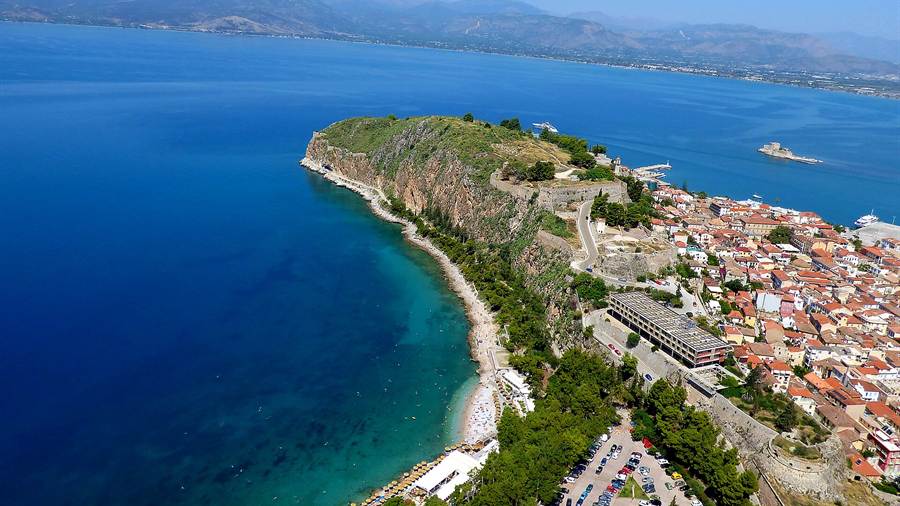
The peninsula behind Peloponnese tours joins the mainland at the Isthmus of Corinth, a land bridge between two gulfs. From the late Middle Ages until the 19th century it was known as the Morea.
The name Peloponnesos means the island of Pelops, a hero said in Greek myth to have conquered the whole region. Heracles and Perseus are also linked with the Bronze Age palaces of the peninsula.
Four south-pointing peninsulas reach into the sea: the Messenian, the Mani, Cape Malea and the Argolid. The Argolid lies in the north-east and holds Mycenae, Epidaurus and Nafplio.
Since antiquity the land has been split into seven regions: Achaea, Corinthia, Argolis, Arcadia, Laconia, Messenia and Elis. The sections below start in Corinthia and the Argolid, the north-east corner.
- Rivers: The Alfeios in the west is the longest river of the peninsula, at 110 kilometres.
- Climate: Rainfall is higher on the west coast, while the east of the peninsula is significantly drier.
- Islands: The Argo-Saronic Islands lie to the east and the Ionian Islands to the west.
- Earthquakes: The entire peninsula is earthquake-prone and has suffered earthquakes in the past.
Peloponnese tours in this part of the hub follow the north-east corner from the isthmus to the Saronic coast, and the sections that follow take each site in turn.


What do Peloponnese tours show at the Corinth Canal?
Peloponnese tours reach the Corinth Canal, a sea-level cutting 6.4 kilometres long that was completed in 1893 and slices through the Isthmus of Corinth, linking the Gulf of Corinth with the Saronic Gulf and sparing ships a long voyage round the peninsula.
On Peloponnese tours the canal has no locks and is 24.6 metres wide at sea level. Its near-vertical rock walls rise 90 metres above sea level, at an angle of 80 degrees.
The Roman emperor Nero broke the ground with a pickaxe in 67 AD, and a workforce of 6,000 Judean prisoners of war dug trenches from both sides. The work stopped when he died shortly afterwards.
Julius Caesar and Caligula also weighed the idea but were assassinated first. Caligula’s Egyptian experts wrongly claimed the Corinthian Gulf sat higher than the Saronic Gulf, which put Aegina at risk.
Work on the modern canal began in earnest after a concession of 1881, stalled when the first company went bankrupt, and ended on 25 July 1893 after eleven years.
- Traffic: Ships pass through one convoy at a time on a one-way system, and larger ships have to be towed by tugs.
- Record: In October 2019 the cruise ship Braemar became the longest ship to pass through the canal.
- Relief: A relief of Hercules left by the workers of Nero can be seen on the north side of the cutting.
- Wartime: In October 1944 retreating German forces blocked the canal with explosives, bridge wreckage and dumped locomotives.
Peloponnese tours treat the canal as a first stop because it marks the gateway to the peninsula. The Corinth Canal tour post covers sailing and walking along the cutting.
What does ancient Corinth add to Peloponnese tours?
Peloponnese tours use ancient Corinth to explain the trading city of the isthmus, a site settled since at least 6500 BC, ruled by the Bacchiadae clan from 747 BC and by the tyrant Cypselus after he seized power in 657 BC.
In 733 BC the city founded colonies at Corcyra and Syracuse, and Periander later founded Potidaea in Chalcidice. The era of the Cypselids is described as Corinth’s golden age.
Peloponnese tours recall that Periander was counted among the Seven Wise Men of Greece, and that the first Corinthian coins were struck during his long reign, which began in 627 BC.
Thucydides credits the Corinthians with developing the trireme, the standard warship of the Mediterranean. Corinth also fought the first naval battle on record, against the Hellenic city of Corcyra.
In the Persian Wars Corinth sent 400 soldiers to Thermopylae, forty warships to Salamis and 5,000 hoplites to Plataea. Corinthian helmets were the characteristic gear of those hoplites.
The Conference at the Isthmus of Corinth in 481 and 480 BC set up the Hellenic League, which allied under the Spartans to fight the war against Persia.
- Modern city: The modern city of Corinth stands about 5 kilometres north-east of the ancient ruins.
- Stone: Local oolitic limestone was quarried at Corinth and traded widely across the Aegean.
- Clay: Deposits of calcareous marl supplied a workable clay for lightweight ceramic vessels.
- Games: Leading families established the Isthmian Games in 581 BC.
Peloponnese tours reach the ruins from the modern city and then climb to the rock above them. The Ancient Corinth tour post covers the excavated ruins of the city.
Where do Peloponnese tours go on Acrocorinth and in the Corinthian highlands?
Peloponnese tours climb Acrocorinth, a fortress rock occupied from archaic times to the early 19th century, and then turn inland to the highlands of Corinthia, where lakes, villages and mountain slopes lie well beyond the coastal plain and the canal.
On Peloponnese tours, Acrocorinth appears as one of the Fetters of Greece with Demetrias and Chalcis, three fortresses garrisoned by the Macedonians in the Hellenistic period to hold the Greek city-states.
Three circuit walls formed the man-made defence of the hill. On the highest peak stood a temple of Aphrodite, later converted into a church and then into a mosque.
The American School began excavating Acrocorinth in 1929, and a forest fire struck the area around the castle on 17 July 2007. Today the rock ranks among the important medieval castle sites of Greece.
Feneos had a population of 1,327 in 2021, and its municipal unit covers 226.201 square kilometres. The Lake Doxa post covers the reservoir near the village of Archaia Feneos.
- Frogs: In certain weather thousands of small green frogs hide in the damp grass around Lake Stymphalia.
- Towns: Loutraki had 12,212 residents and Kiato 9,907 in the 2021 census.
- Roads: The EO8a road, now largely replaced by the A8 motorway, opened east of Corinth in 1962 and west of it in 1969.
- Villages: Large concentrations of Arvanite descendants live in mountain settlements such as Xylokeriza and Sophiko.
Peloponnese tours join the fortress rock to the uplands of Corinthia, and the next stop in the same regional unit is the wine country of Nemea.
What do Peloponnese tours show at Nemea?
Peloponnese tours stop at Nemea, an ancient sanctuary of Zeus in the north-east Peloponnese where the Nemean Games were held, with a fourth-century BC Temple of Zeus, a Hellenistic stadium and an on-site museum that displays the finds from the excavations.
The temple was built on top of an earlier version of the sixth century BC that burned down, and only a foundation wall of that first temple is visible.
Peloponnese tours explain that the finished temple had 32 limestone columns in a layout of six by twelve, three of which have stood since their construction. Two more were reconstructed in 2002.
The Hellenistic stadium sits in a natural hollow between two ridges, and its track was originally 600 feet long. Spectators sat on the earth embankments, since only a handful of stone seats were found.
The sides of the track still have a stone water channel with water basins fed originally from a spring for the athletes, and stone starting blocks with grooves for the runners’ toes remain in place.
- Oikoi: Nine poorly preserved buildings south of the temple are called oikoi, from the Greek word for houses.
- Dining: The eighth and ninth oikoi formed a dining establishment with room for up to eleven couches.
- Kilns: Four kilns produced roof tiles for the renovation funded by the Macedonian kings.
- Changing room: Roof-tile stamps on the apodyterion, where athletes prepared, reveal the name of the architect Sosikles.
Peloponnese tours pair the sanctuary with the vineyards of the Nemea region. The Nemea wine tour post covers the town of Nemea and its wine.
Why do Peloponnese tours include Mycenae?
Peloponnese tours include Mycenae because the hill citadel gave its name to the Mycenaean period, dated from about 1600 BC to about 1100 BC, and because it won a place on the UNESCO World Heritage List in 1999 alongside Tiryns.
On Peloponnese tours Mycenae is dated to its peak in 1350 BC, when 30,000 people lived in the citadel and lower town. The Cyclopean walls took their name from the one-eyed giants of Greek myth.
The Lion Gate, built around 1250 BC, is 3.10 metres wide at the threshold and was closed by a double door. Its lintel measures 4.5 by 2.0 by 0.8 metres.
The largest stones, including the lintels and gate jambs, weighed well over 20 tonnes. A secret passage under the wall leads down 99 steps to a cistern cut from the rock 15 metres below the surface.
The gold Mask of Agamemnon came from Grave V in Grave Circle A, where eight men were found with weapons but only five had masks, all in Graves IV and V.
- Houses: The excavated houses outside the walls include the House of Shields, the House of the Oil Merchant, the House of the Sphinxes and the West House.
- Rediscovery: In 1700 the Venetian engineer Francesco Vandeyk identified the ruins from the description of the Lion Gate by Pausanias.
- Collapse: Mycenae was among the sites destroyed in the Bronze Age Collapse around 1200 BC.
- Later temple: A temple of Hera was built on the summit of the citadel in the Archaic Period.
Peloponnese tours pair the citadel with the theatre at Epidaurus on one route through the Argolid. The Mycenae Epidaurus day trip post covers the two sites together.
What do Peloponnese tours show at Tiryns?
Peloponnese tours show Tiryns as the Bronze Age hill fort 20 kilometres south of Mycenae, where walls up to 17 metres thick and a palace with a central hearth explain how Mycenaean kings guarded their citadels and secured a water supply.
Tiryns was a hill fort occupied for seven thousand years, and it reached its height between 1400 and 1200 BC. Homer called it mighty walled Tiryns, and tradition held that the Cyclopes built the walls.
The surviving walls reach seven metres in height in places, against an original height estimated at nine to ten metres. Pausanias wrote that two mules pulling together were unable to move even the smaller stones.
Peloponnese tours note that tunnels with triangular roofs run inside the thick walls of the northern section and served as refuges for the lower city in times of danger. Three springs fed the compound.
Around 1300 BC the citadel and lower town held 10,000 people over 20 to 25 hectares, and by 1150 BC the population reached 15,000. Excavations began in 1831 under Rangavis and Thiersch.
- Palace: The palace measured 11.8 by 9.8 metres and had a portico, an anteroom and a main room with a circular hearth.
- Plataea: Herodotus records 400 hoplites from Tiryns at the Battle of Plataea.
- Halieis: Strabo says that Tirynthians moved to found Halieis, the modern Porto Heli.
- Desertion: The site was completely deserted when Pausanias visited in the second century AD.
Peloponnese tours place Tiryns beside Mycenae, and Greek legend links the hill with Heracles, who was said to have performed his Twelve Labours from here.
How do Peloponnese tours treat Argos and its Heraion?
Peloponnese tours treat Argos as one of the three major cities of the ancient peninsula, with Corinth and Sparta, and visit the nearby Heraion, a sanctuary of Hera that served the communities of the Argive Plain from the eighth century BCE.
Peloponnese tours recall that Argos conquered the nearby states of Mycenae, Tiryns and Midea in 460 BCE, and the Heraion was renovated and expanded to reflect its dominant position on the plain.
Thucydides records that the Old Temple burned down in 423 BC, when the priestess Chrysis left a torch too close to the garlands. A new temple followed between 420 and 410 BCE.
The Old Temple Terrace, measuring 55.80 by 34.40 metres, was the first structure built at the Heraion, in the late eighth or early seventh century BCE. The North Stoa measures 62.10 by 9.20 metres.
Festivals included a procession from Argos in which, according to Herodotus, the brothers Kleobis and Biton pulled the cart of their mother, a priestess of Hera, up to the sanctuary by hand.
- City: Argos had 24,700 inhabitants in the 2011 census.
- Homer: Hera says in the Iliad that Argos, Sparta and Mycenae are the three towns she loves best.
- Venice: The Venetians lost Argos in the first Ottoman-Venetian war, which lasted from 1463 to 1479.
- Votives: Figurines of women, children and warriors show Hera as a protector of both the family and the state.
Peloponnese tours then move on from the Argive Plain to the port of Nafplio, which a branch railway line of ten kilometres links to Argos.
Why is Nafplio a base for Peloponnese tours?
Peloponnese tours use Nafplio, the capital of Argolis on the Argolic Gulf, as a base because the old town on its peninsula keeps Venetian streets and fortresses and lies in the same regional unit as Mycenae, Epidaurus and Argos.
Peloponnese tours trace Nafplio back to the Aegean List from the mortuary temple of Amenhotep III, which dates the oldest reference to the 14th century BCE. In antiquity it served as the port of Argos.
Frankish crusaders took the town in 1212, and in 1388 the lordship of Argos and Nauplia was sold to Venice, which expanded and fortified the lower city over the following 150 years.
Venice twice repelled Ottoman sieges at Nafplio, first by Mehmed the Conqueror and then by Suleiman the Magnificent. In 1685 the Venetians retook the town and made it capital of their Kingdom of the Morea.
During the Greek War of Independence the Ottoman garrison was besieged for more than a year and surrendered through starvation. Afterwards the town became the seat of the provisional government of Greece.
- Bay: The peninsula of the old town forms a naturally protected bay that human-made moles enhance.
- Farming: The surrounding irrigated plain produces oranges, lemons, peaches, apricots, olives and almonds.
- Architecture: The city holds the only example of Mycenaean Revival architecture, a branch of the National Bank of Greece.
- Port: The port of Nafplio handles only bulk cargo because its depth is insufficient, and it also hosts leisure ships during the tourist season.
Peloponnese tours reach Nafplio by the road from Athens through Corinth and Argos. The Nafplio day trip post covers the town and the sites around it.
What do Peloponnese tours include at Palamidi and Bourtzi?
Peloponnese tours include Palamidi, a Venetian baroque fortress with eight bastions on a hill above Nafplio, and Bourtzi, the fortress that stands in the middle of the harbour, two defences that together tell the story of the sieges of Nafplio.
On Peloponnese tours Palamidi appears as a very large and ambitious project, a typical baroque fortress planned by the Venetian engineer Antonio Giancix and built by the French military engineer Pierre de la Salle.
The eight bastions were named first after Venetian provveditori, then given Turkish names, and finally renamed after ancient Greek leaders and heroes such as Epaminondas, Miltiades and Leonidas.
The Miltiades bastion served as a prison, and Theodoros Kolokotronis, hero of the Greek Revolution, was held within its walls. Two further bastions honour Saint Andrew and the French philhellene Robert.
Palamidi was the last major construction of the Venetian empire overseas, yet only 80 soldiers were assigned to defend the city when the Ottomans retook it in 1715.
The hill fortress was built during the second Venetian occupation of the area, which lasted from 1686 to 1715, on the crest of a hill east of the Acronauplia.
- Name: The word Bourtzi comes from an Ottoman Turkish and Arabic word meaning tower.
- Fame: The Bourtzi of Nafplio is the best known of the fortresses that carry the name.
- Namesakes: Other fortresses called Bourtzi stand at Aegina, Poros, Methoni and Karystos.
- Ruins: The Bourtzi at Aulis is a ruined castle, and the Venetian Bourtzi at Chalkis has been demolished.
Peloponnese tours therefore read Nafplio through its two fortresses, one built on the hill in the last years of Venetian rule and the other set in the harbour.
What do Peloponnese tours show at Epidaurus?
Peloponnese tours show Epidaurus, the healing sanctuary of Asclepius, whose ancient theatre joined the UNESCO World Heritage List in 1988 and holds between 13,000 and 14,000 spectators, with a lower theatre of 12 sections and an upper epitheatre of 22.
The two parts of the auditorium are separated by a horizontal corridor 1.82 metres wide for the movement of spectators, and the lower rows are reserved for important people.
The circular orchestra has a diameter of 20 metres, and an underground drainage channel called the euripos, 1.99 metres wide, surrounds it. A circular stone slab at its centre marks the altar base.
Peloponnese tours explain the acoustics of the theatre: the limestone seats filter out low-frequency sounds such as the murmur of the crowd and amplify the high-frequency sounds of the stage.
The first modern performance was Sophocles’s tragedy Electra in 1938, directed by Dimitris Rontiris and starring Katina Paxinou. After the war the festival resumed in 1954 and became annual in 1955.
The cult of Asclepius is attested at Epidaurus in the sixth century BC, when the older hill-top sanctuary of Apollo Maleatas was no longer spacious enough. A visit by Hadrian in AD 124 revived the site.
- Town theatre: The town of Epidaurus had its own theatre of about 2000 seats, excavated since 1990.
- Raid: In AD 395 the Goths raided the sanctuary.
- Territory: Epidaurus was independent of Argos until Roman times and formed the small territory of Epidauria.
- Restoration: The Preservation Committee for Epidaurus Monuments restored the theatre from 1988 to 2016.
Peloponnese tours reach the theatre on the western side of Cynortion Mountain, near the modern village of Lygourio. The Epidaurus tour post covers the sanctuary and the theatre.
Which coastal places do Peloponnese tours reach in the Argolid?
Peloponnese tours reach the coast of the southern Argolid at Ermioni, Kranidi and Porto Cheli, where a resort sits on the Argolic Gulf and a prehistoric cave above Kiladha Bay was used as a shelter by early humans for around 35,000 years.
On Peloponnese tours Ermioni appears as a small port town on the Argolid Peninsula. Its municipal unit covers 168.180 square kilometres, and the town lies about 17 kilometres south-west of Porto Cheli.
In the classical period Hermione was known for the production of porphyra, a red dye used to colour the uniforms of armies including that of Alexander the Great.
Pausanias described a stoa of Echo at Hermione that repeated a voice three times, and a temple sacred to Poseidon on the long promontory of the old city.
Kranidi lies in low hills covered with olive groves and small forests, about 4 kilometres from the coast. Its villages on the Aegean shore include Koilada, Portocheli and Doroufi.
The island of Spetses lies 6 kilometres south of Porto Heli, and a small private airport south of the town closed in 2004, although the land was later sold.
- Poet: Lasus of Hermione was a Greek poet of the sixth century BC.
- Research: Greek and Swedish archaeologists have worked at ancient Hermione since 2015.
- Language: Arvanitika was spoken in Kranidi and the surrounding villages, and today only elders speak it.
- Alliance: Hermione is mentioned first among the cities of the Amphictyony, which met on the island of Calaureia.
Peloponnese tours reach the same coast by water as well as by road. The Ermioni boat trip post covers the waters around Ermioni.
What do Peloponnese tours show in Arcadia?
Peloponnese tours enter Arcadia, the mountainous centre of the peninsula, which counted 77,592 inhabitants in the 2021 census and holds three high mountain ranges, with limestone basins that drain underground, and a long pastoral reputation in European art.
Mount Lykaion rises in the southwest, Parnon in the south and Mainalo in the north. Winters bring snow to Mainalo and Taygetus, while Peloponnese tours cross the ranges by road.
After the Fourth Crusade the area became part of the Principality of Achaea. Byzantine Greeks of the Despotate of the Morea then recovered it step by step from the 1260s onward.
The Latin phrase Et in Arcadia ego, a reminder that death reaches even paradise, is linked with a painting of 1647 by Nicolas Poussin. Peloponnese tours reach the real hills behind that pastoral image.
An earthquake of magnitude 5.9 shook Megalopoli in 1965 and revealed a source of lignite underground. Work on the Megalopoli Power Plant began in 1967, and the plant started work in 1970.
- Capital: Tripoli, the main town, has about 30,400 residents in the city proper.
- Historian: Polybius, a Greek historian of the Hellenistic period, came from Megalopolis.
- General: Philopoemen of Arcadia, known as the last of the Greeks, lived from 253 to 183 BC.
- Dialect: The older Arcadocypriot Greek language survived in Arcadia after Doric Greek reached the peninsula.
The Arcadia mountain villages post covers the stone settlements of the highlands village by village. Peloponnese tours use Arcadia as the link between the northern coast and the Laconian south.
Why do Peloponnese tours visit the Lousios Gorge?
Peloponnese tours visit the Lousios Gorge in western Arcadia because it joins a forested river valley with steep walls, village libraries, monasteries on the cliffs and a medieval castle town, all within reach of Dimitsana, Stemnitsa and Karytaina.
According to tradition, Zeus washed at the sources of the Lousios after his birth, and the river took its name from that act. Pausanias considered it the coldest river in the known world.
Peloponnese tours reach Dimitsana, which stands on a slope at 950 metres on the ruins of ancient Teuthis. Philosophou Monastery was founded near it in 963, and a water-power museum of 1997 restores a flour mill.
The library of Dimitsana holds about 35,000 books, manuscripts and documents. A monk named Agapios built it in 1764 by moving the books of the monastery, and the seminary beside it taught Patriarch Gregory V.
Stemnitsa lies at 1,050 metres above the left bank and was known for gold and silver work. A public school for smiths has run there since the 1970s, and the church of Bafero dates from 1185.
- Monastery: The Prodromos monastery, built around 1167 on a rock face, stands near the ruins of an ancient hospital of Asclepius.
- Castle: The castle of Karytaina was built in the mid-13th century by Baron Geoffrey of Briel, with a triangular wall circuit.
- Bridge: A bridge of five arches, 50 metres long, crosses the Alpheios at Karytaina.
- Nickname: Karytaina is called the Greek Toledo, and it appeared on the reverse of the 5000 drachma banknote.
The Lousios Gorge hike post covers the river path and the villages at either end. Peloponnese tours place the gorge between the central uplands and the plain of Megalopoli.
What do Peloponnese tours find in Tripoli and Mantineia?
Peloponnese tours use Tripoli, whose municipality had 44,165 inhabitants in 2021, as the central hub of the Peloponnese interior, and then turn to ancient Mantineia, where the largest land battle of the Peloponnesian War took place in 418 BC.
Tripoli sits at the western edge of a basin, a polje about 650 metres high and 30 kilometres long. Closed basins drain through 45 ponors, and winter floods form the temporary Lake Taka in the southwest.
In spring 1770, during the Orlov revolt, Albanian mercenaries of the Ottomans killed 3,000 Greeks within hours of entering the city. Greek insurgents stormed it on 17 October 1821 during the war of independence.
Ibrahim Pasha retook the city on 22 June 1825, and before he left the Peloponnese in early 1828 he destroyed it and tore down its walls. The Greek state later rebuilt it.
Peloponnese tours reach Mantineia, formed around 500 BC from neighbouring villages, with Poseidon as patron god. In the First Battle of Mantineia, Sparta and its allies routed Athens and its allies after Athenian commander Laches fell.
- Priestess: Diotima, who influenced Socrates, was said to be a priestess at the temple of Artemis Hymnia.
- Marble: The Mantineia Marble of the 4th century BC shows the contest of Apollo and Marsyas and is held in Athens.
- Democracy: A democracy ran at Mantineia by 420 BC, and Aristotle noted that a special committee elected its officials.
- Emperor: Hadrian restored the name of Mantineia and in 130 AD built a temple dedicated to Antinous.
Peloponnese tours treat the two as a pair, the modern crossroads of the interior and the ancient field where Spartan and Athenian armies met, before the road turns south towards Sparta.
How do Peloponnese tours cover Sparta?
Peloponnese tours cover Sparta, the capital of Laconia, a city created when King Otto decreed in 1834 the expansion of the small town among the ruins, and a place with an acropolis, a sanctuary of Apollo nearby and an ultramarathon finish.
Peloponnese tours reach the ruins of ancient Sparta north of the modern city, entering by the South Gate of the Acropolis, past the Rotunda and the Theatre, with the Temple of Athena Chalkioikos to the west.
Peloponnese tours reach Amyclae, a city of the Heroic Age on the right bank of the Eurotas, 20 stadia south of Sparta. It was known for its temple and a colossal statue of Apollo.
The Tomb of Leonidas, a limestone building of the late 5th century BC, is thought to be a temple. It gained the name in the 19th century as the only ancient monument in the planned town.
The Spartathlon ultramarathon covers 246 kilometres from Athens to Sparta and has run since 1983. It finishes at the statue of Leonidas, passes 75 checkpoints and limits the field to 400 runners.
- Heat: Sparta recorded 45.7 degrees Celsius in August 2021, the highest temperature on its record.
- Menelaion: The Menelaion, a hero shrine of Menelaus and Helen from about the 8th century BC, stands on a ridge near Therapne.
- Sellasia: In 222 BC Macedon and the Achaean League beat King Cleomenes III of Sparta at Sellasia on the northern border of Laconia.
- Title: The Greek crown prince bore the title Duke of Sparta until a referendum abolished the monarchy in 1973.
Peloponnese tours use the modern city as a base for the Evrotas Valley, the hill town of Mystras to the west and the coast around Gytheio to the south.
What do Peloponnese tours see at Mystras?
Peloponnese tours climb to Mystras, the late Byzantine hill town above Sparta, with its steep footpaths, a palace of three storeys, painted churches and houses built over cisterns, all set on a steep slope of the Taygetus range.
The steep slope made wheeled vehicles impractical, so Peloponnese tours climb Mystras on footpaths. The town has distinct upper and lower zones, and its markets stood outside the city walls.
The Palace of the Despots grew over the fourteenth and fifteenth centuries from adjoining units. Its final main building follows the Tekfur Saray of Constantinople, with three storeys and a large audience hall on top.
Peloponnese tours pass the Monemvasia Gate and the Nauplia Gate, named for other towns. The plan of the site also lists the Mavroporta, the Church of the Taxiarchs, the Church of Saint Nicholas and Krevatas House.
Gemistos Plethon tutored the young despot Theodore II at Mystras. In 1439 he accompanied Emperor John VIII Palaiologos to Florence, and the scholars of Mystras influenced the Italian Renaissance.
- Residents: Only a group of nuns at the Pantanassa Monastery live on the site today.
- Palace: The Palace of the Despots is the only Byzantine palace that survives.
- Relocation: Families moved to Sparta or to a small village called New Mystras, and the process ended in 1953.
- Frescoes: The churches carried elaborate frescoes in the Palaeologan Renaissance and were known for their libraries.
The Mystras tour post covers the castle, the Despotate and the churches in more detail. Peloponnese tours add the town to the road between Sparta and the foothills of Taygetus.
Why do Peloponnese tours stop at Monemvasia?
Peloponnese tours stop at Monemvasia, the walled medieval town on a rock off the east coast of Laconia, whose Greek name means the city of the single approach and which earned the nickname the Gibraltar of the East.
Peloponnese tours also meet the name Akra Minoa, the Minoan promontory, which Pausanias used for the rock. In 1292 Roger of Lauria sacked the lower town, and in 1302 the town welcomed the Catalan Company.
In 1147 ships of King Roger II of Sicily tried to take the town and withdrew with heavy losses. Venetian attacks in 1653 and 1655 failed, and the Ottomans granted a domed church.
The census of 1828 counted only 659 inhabitants, and in 1971 just 32 people lived in the old town. Cisterns supplied its water until 1964, and electricity arrived in 1972.
The Venetian commander Girolamo Corner entered the town on 12 August 1690 after it surrendered. Its population reached 1,622 inhabitants by 1700, almost double the count ten years earlier.
- Name: Ottoman Greek names for the town, such as Menexe, mean violet.
- Pirates: Arab raids began in the 9th century and multiplied after the Arabs settled in Crete.
- Festival: On 23 July a ship filled with fireworks is burned in the port, and the story of Tzannetakis Grigorakis is told.
- Report: The 15th-century Report to the Patriarch was written by Isidoros, the metropolitan of Monemvasia.
The Monemvasia tour post covers the lower town, the gate and the upper fortress. Peloponnese tours reach the rock by the coast road from the Evrotas Valley.
What do Peloponnese tours cover in the Mani?
Peloponnese tours cover the Mani, the central of three southern peninsulas between the Laconian and Messenian gulfs, a rugged limestone country of tower houses once called Maina Polypyrgos, whose southern part is a protected area for migrating birds of prey.
From 1978 the Greek state decreed settlements with tower houses traditional, which set limits on new building. In 2003 the whole peninsula was designated a cultural complex of international importance.
The southern part of the peninsula, about 317 square kilometres, is a Natura 2000 Special Protection Area. It was designated in 2010, holds 72 bird species and shelters Bonelli’s eagle.
Peloponnese tours reach Cape Matapan, where a temple of Apollo stood and was later rededicated to Poseidon. In myth, a sea-hollowed cavern near the cape served as a portal to Hades, the underworld.
Outer Mani, on the Messenian side, receives more rainfall than the Laconian side, which lies in a rain shadow. Locals call the Messenian side shady and the Laconian side sunny.
- Tortoises: The marginated tortoise is densely distributed through the Mani.
- Boar: Wild boar, extinct in the Peloponnese by about 1830, were reintroduced between 1988 and 2004.
- Melingoi: The Slavic Melingoi lived in fortified settlements in the north-west and moved livestock up and down Taygetus with the seasons.
- Groves: Olive groves on terraced lower slopes are mainly farmed without herbicides.
The Diros caves tour post covers the show caves near Areopolis in the south-west of Laconia. Peloponnese tours reach them by the road through the Mani.
Why do Peloponnese tours reach Gytheio?
Peloponnese tours reach Gytheio, the largest town of the Mani and the ancient seaport of Sparta, whose island of Cranae is linked in myth with the first night that Paris and Helen spent together before they sailed for Troy.
In 455 BC the Athenian admiral Tolmides burned Gytheio, besieging it with 50 ships and 4,000 hoplites. The Spartans rebuilt it, and in 407 BC Alcibiades landed there and saw thirty triremes under construction.
Peloponnese tours hear that in 370 BC Thebans under Epaminondas besieged the city for three days, but the Spartans recaptured it three days later. Philip V of Macedon failed to take it in 219 BC.
Under Roman rule Gythium belonged to the Union of Free Laconians, a league of twenty-four, later eighteen communities declared free by Augustus. It exported purple dye, porphyry and rose antique marble.
A Roman theatre, found by the archaeologist Dimitris Skias in 1891, survives well and remains in use. A massive earthquake in 375 AD is one proposed explanation for the end of the ancient city.
- Causeway: Cranae, home of a tower and a lighthouse, was linked to the mainland by a causeway in 1898.
- Port: The modern port opened in the 1960s.
- Turtles: Loggerhead turtles nest on beaches near Gytheio at Mavrovouni, Valtaki and Selinitsa.
- Dye: Murex sea snails, still plentiful off Gytheio, supplied Tyrian purple in the early Greek Dark Ages.
Peloponnese tours treat the port as the maritime door of Sparta, and the road south-west leads on towards Areopolis and the deeper Mani.
What do Peloponnese tours find on Mount Taygetus?
Peloponnese tours find on Mount Taygetus a limestone range that overlooks Sparta and Kalamata, shelters ancient beehive tombs, sends snowmelt down the Vyros Gorge to the Messenian Gulf, and forms the backdrop of the village of Kardamyli on that coast.
The western side of the massif holds the headwaters of the Vyros Gorge, which carries winter snowmelt down the mountain and empties into the Messenian Gulf in the town of Kardamyli.
Peloponnese tours reach Kardamyli, a trailhead for mountain paths up to the summit. The nearby Viros Gorge is 20 kilometres long, dry in summer, and floods regularly in winter with snowmelt and heavy rain.
Patrick Leigh Fermor, an English writer, lived in Kalamitsi just outside Kardamyli in his later years. The village made him an honorary citizen for his participation in the Greek Resistance.
The slopes have been inhabited since at least Mycenaean times, and the site of Arkina near Arna has three beehive tombs. Homer names Kardamyli in the Iliad among seven cities that Agamemnon offered to Achilles.
- Tombs: The tombs of Castor and Pollux are believed to lie near a hiking trail above old Kardamyli.
- Plant: In antiquity women tied a mountain plant called Charisia around their necks to be more loved by men.
- Shelter: During the era of barbarian invasions the mountain sheltered the native population, and its slope villages date from that period.
- Peak: In antiquity the peak Taleton was dedicated to Helios, with horse sacrifices, and to Zeus.
Peloponnese tours see Taygetus from Sparta, from Mystras and from the Messenian coast, and each view shows a different face of the same limestone massif.
Why do Peloponnese tours include Elafonisos?
Peloponnese tours include Elafonisos, a small island of 19 square kilometres between the Peloponnese and Kythira, where light sandy beaches with blue-green water draw thousands of day visitors in summer and a sunken Bronze Age town lies offshore.
The population stands between 300 and 350 in winter. In July and August Peloponnese tours share the island with over 3,000 visitors a day, who bring about 1,600 cars.
Sarakiniko, Fragos, also called Simos, and Panagias Nissia are the best-known beaches. The island is the largest inhabited island of the Peloponnese archipelago and the only one that forms a separate municipality.
In antiquity Elafonisos was a peninsula called Onou Gnathos, meaning the donkey’s jawbone, according to Pausanias. The main church, Agios Spyridon, stands on a tiny piece of land linked by a bridge.
Offshore lies Pavlopetri, a sunken city dating from the early third millennium BC and thought to have been claimed by the sea around 1000 BC. A Cambridge survey began in 1968.
- Mainland: Neapoli on the mainland lies 6.5 km from the island.
- Kythira: Cape Frangos on Kythira lies 8.5 km to the south.
- Punta: The community also includes 3 square kilometres of the mainland, mainly Punta Beach.
- Tombs: The drowned town ran from 60 rock-cut tombs on the Pounta shore to wall remains off Elafonisos.
Peloponnese tours reach the island from the Vatika coast of the mainland. Elafonisos became part of the Laconia prefecture in 1864, after the incorporation of the Ionian Islands into Greece.
What do Peloponnese tours reveal about Mount Parnon?
Peloponnese tours reveal Mount Parnon as a limestone massif east of the Laconian plain and the Evrotas Valley, with forest below a tree line at 1,750 metres, grassland above it and caves that include the fifth deepest in Greece.
The massif has three parts. The northernmost and highest runs 30 kilometres from north of Ano Doliana to the Platanaki Pass, and its peaks include Psaris at 1,836 metres.
Black pine and fir grow below the tree line at 1,750 metres, and grassland lies above it. Altitudes in the north rise from 1,100 metres to 1,600 to 1,800 metres near the peak.
The range is mainly limestone. It holds the Peleta Sinkhole, which reached a depth of 543 metres in 2006 and ranks as the fifth deepest cave in Greece, and the vertical cave Propantes at 360 metres.
Peloponnese tours learn that UNESCO has designated the mountain a biosphere reserve, and its summit offers views of southeastern Arcadia, much of Laconia and the Myrtoan and Laconian Gulfs.
- Tsakonian: Derived from Doric Greek, the language declined from an estimated 200,000 fluent speakers to between 200 and 1,000 by 2007.
- Eggplant: The Tsakonian eggplant of the Leonidio area has a sweet taste and is protected by the European Union.
- Climbing: Leonidio has developed into an important climbing destination in Greece.
- Pass: Platanaki, ancient Glyppia, lies on the ancient route from Therapnes to South Kynouria.
Peloponnese tours meet Parnon from the Laconian plain on the west side and from Kynouria on the east side, so the range frames two different landscapes.
What do Peloponnese tours taste among the olive groves of Laconia?
Peloponnese tours taste Laconia through the Kalamata olive and its oil, Tsakonian eggplant, Maniot pork and lamb soup, lamb or goat meat and pumpkin pie, the specialities that mark the table of the southern Peloponnese, from the Evrotas Valley to the Mani.
Peloponnese tours learn that Kalamata olives, which cannot be harvested green, must be hand-picked to avoid bruising. The short method of debittering uses water or weak brine, and the long method uses strong brine.
The Evrotas Valley contains about 7000 wells. Water drawn for irrigation leaves large sections of the river dry on the surface, though Peloponnese tours still see the groves it feeds.
The Evrotas rises at springs near Skortsinos and is fed by underwater springs at Pellana. Its drainage basin covers 2,239 square kilometres, which Peloponnese tours cross between Taygetus and Parnon.
In 1992 a large fire ruined the finest olive crops in the north of Laconia, around Sellasia and Oinountas, and flooding along the Eurotas in 2006 ruined olive and citrus crops.
- Preservation: Kalamata olives are preserved in wine vinegar or olive oil.
- Syglino: Syglino is a pork dish of the Mani, and regali is a lamb soup of the same peninsula.
- Giosa: Giosa is a Peloponnese speciality of lamb or goat meat.
- Pie: Kolokythopita is a pumpkin pie, and galatopita is a dessert, among the specialities of the region.
Peloponnese tours close the Laconian chapter at the table, with olives, oil and local dishes, before the road turns west across Taygetus towards Kalamata and Messenia.
What do Peloponnese tours show in Kalamata?
Peloponnese tours reach Kalamata, the largest city of Messenia, which lies along the Nedon River. The wider municipality covers 440 square kilometres and counted 72,906 inhabitants in the 2021 census, while the municipal unit alone covers 253 square kilometres.
The name has two proposed origins. One is a church dedicated to the Virgin Mary. The other is the older name Kalamai, which means reeds. Peloponnese tours can open with either story.
Kalamata occupies the site of ancient Pharae, a city that Homer mentions. Remains of a Temple of Poseidon, unearthed in the Akovitika district, show that the area was land and not sea in ancient times.
The town prospered as the capital of the fertile Messenian plain in the eleventh and twelfth centuries, and five churches of that age survive, among them the Church of the Holy Apostles.
After the Fourth Crusade, William of Champlitte and Geoffrey of Villehardouin conquered Kalamata in 1205. Prince William II of Villehardouin was born and died there. The Ottomans occupied the town in 1481.
- Hainaut: Matilda of Hainaut held Kalamata as her fief from 1298 until 1322.
- Morosini: The Venetian commander Francesco Morosini took the town in 1659, because the Ottomans abandoned it.
- Province: The former province of Kalamata matched today’s municipalities of Kalamata and West Mani.
- Industry: The Karelia tobacco company is based in Kalamata.
The Kalamata food tour post covers the city’s tastings of olives and sweets. Peloponnese tours use the city as a base for western Messenia, and the next sections follow the road to its ruins and castles.
Why do Peloponnese tours visit Ancient Messene?
Peloponnese tours visit Ancient Messene, a local community in the Messenia regional unit, known for its extensive ruins. The large restored structures date from the Hellenistic and Roman periods, and a museum of the excavation finds stands inside the old city walls.
In Middle Byzantine times, after the tenth century, the township of Voulcano grew on the site with rich material remains. The settlement continued through the late medieval Frankish and Ottoman periods.
The returning exiles came primarily from Sicily and North Africa. Peloponnese tours reach a city that they rebuilt, where the long struggle with Sparta ended only with the Macedonian conquest of Greece.
The exiles who returned had kept a Doric dialect through about 300 years abroad. Pausanias reports that they preserved it in its purity better than anywhere else in the Peloponnese.
The walls took in Mount Ithome and enough farmland and spring captures to withstand a siege indefinitely. The policy proved right when the Spartans tried to retake Messenia after the Theban army left.
- Founding: Engineers, artisans and armies finished the walled city in 85 days.
- Bishop: From the fifth century AD the site was rebuilt as a Christian city and the seat of a local bishop.
- Crisis: New populations settled in the region during the seventh and eighth centuries.
- Dig: Since 2020 the Open University of Cyprus has excavated an early Christian church east of the precinct of Asclepius.
The Ancient Messene tour post covers the formats on sale and the monuments that still stand on the site. Peloponnese tours can pair the site with Bassae or Kalamata.
How do Peloponnese tours cover Pylos and Navarino?
Peloponnese tours cover Pylos, a town of 2,568 inhabitants on the Bay of Navarino. Excavations show a continuous human presence in the Pylia district from 5300 BC, and the Mycenaean kingdom of Nestor later made Pylos a centre of the Bronze Age.
The name Navarino comes from the Greek Avarinos, a word of uncertain origin. Modern scholarship derives it from a Slavic name meaning place of maples, not from the Navarrese Company.
Venice held Pylos from 1417 until 1500, when the Ottoman Empire conquered it. The Ottomans used Pylos and its bay as a naval base and built the New Navarino fortress there.
Peloponnese tours reach the land of a Mycenaean state that covered 2,000 square kilometres. According to the Linear B tablets, its population was at least 50,000, and estimates reach 120,000.
The palace had two storeys, with stores, workshops, baths, reception rooms, light wells and a sewage system. Fire destroyed the complex around 1250 BC, and a modern roof with raised walkways now covers it.
- Tablets: About 1,000 Linear B tablets turned up in 1939 and went to the National Archaeological Museum in Athens.
- Decipherment: Michael Ventris showed in 1952 that the script was an archaic form of Greek.
- Murals: The prehistoric frescoes proved to be egg tempera, among the oldest examples in the world.
- Tomb: In 2015 the University of Cincinnati found the undisturbed burial of a warrior with gold rings and bronze weapons.
The Pylos tour post covers the town, its castles and the bay. Peloponnese tours add the palace north of the town, where the tablets came to light.
Which castles do Peloponnese tours reach at Methoni and Koroni?
Peloponnese tours reach Methoni and Koroni, two Messenian ports that Venice took in 1206 or 1207 and held for three centuries. A Venetian document called the pair the chief eyes of the Republic because they controlled the Levant trade.
Methoni is identified with Pedasus, which Homer calls ampeloessa, meaning of vine leaves. It stands last among the seven well-peopled cities that Agamemnon offers Achilles to calm his rage.
The Treaty of Sapienza of June 1209 confirmed the Venetian possessions. Under Venice, Methoni became a trade centre with Egypt and the Levant and a staging point for pilgrims to the Holy Land.
Koroni was famous for its cochineal, from which makers produced crimson dyes. Its Venetian engineers also became known for siege engines. One Latin bishop of Koroni, Angelo Correr, later became Pope Gregory XII.
Peloponnese tours record that Sultan Bayezid II supervised the siege of Methoni in person and that the town fell on 9 August 1500. Koroni and Navarino surrendered on 15 or 17 August 1500.
- Koroni: The town had 1,193 inhabitants in 2021 and lies 56 kilometres by road southwest of Kalamata.
- Rockets: A sounding rocket site near Koroni worked from 1966 to 1989, and early launches reached 114 kilometres.
- Traveller: François-René de Chateaubriand landed at Methoni on 10 August 1806 to begin a Grand Tour.
- Return: The fortress of Methoni surrendered to the French Morea Expedition on 8 October 1828.
The departing French handed Methoni to the new Kingdom of Greece in 1833. Peloponnese tours therefore meet in these two castles the work of Venice, the Ottoman Empire and France.
What do Peloponnese tours find at Bassae?
Peloponnese tours find at Bassae the Temple of Apollo Epicurius, built between 450 and 400 BC in a remote sanctuary of Apollo. The temple stands almost complete, and only the Theseum at Athens is better preserved among Greek temples.
Peloponnese tours learn that the title Epikourios means assistant in evils of war. The people of Phigaleia, helped by their neighbour Oresthasium, retrieved their land from the Spartans and raised a sanctuary to Apollo under it.
Pausanias names Iktinos, the architect of the Parthenon, as designer. Modern scholars doubt this, since the Doric order resembles the Parthenon yet looks old-fashioned where the two differ.
The Doric peristyle has six columns by fifteen, and the temple lacks refinements found in the Parthenon, such as a subtly curved floor. Its walls are grey Arcadian limestone.
Inside, a continuous Ionic frieze ran around the naos and showed Athenians in battle with Amazons and Lapiths in battle with Centaurs. The British Museum bought the frieze at auction in 1815.
- Discovery: The French architect J. Bocher noticed the temple in November 1765 and was murdered by bandits when he returned.
- Drawings: The careful drawings of the site made by Carl Haller von Hallerstein in 1811 were lost at sea.
- Excavation: Russian archaeologists carried out the first fully published excavation, begun in 1836.
- Greek dig: Konstantinos Kourouniotis led a systematic excavation for the Greek Archaeological Society in 1902.
Pagan temples closed across the late Roman Empire, and the remote site left the building unusually well preserved. Peloponnese tours reach it in northeastern Messenia, south of Andritsaina.
Why do Peloponnese tours include Olympia?
Peloponnese tours include Olympia, a small town in Elis beside a sanctuary whose Temple of Zeus rose between 472 and 456 BC. The temple sheltered a colossal ivory and gold statue of Zeus, made by the sculptor Phidias for the Eleans.
On Peloponnese tours the temple appears as a Doric building of poros stone, coated with a thin layer of stucco to look like marble. Its roof tiles were Pentelic marble cut thin enough to be translucent.
The roof edge carried 102 lion-head waterspouts, and 39 survive. Pausanias gave the temple a height of 68 feet, a breadth of 95 feet and a length of 230 feet.
The statue of Zeus stood about 12.4 metres tall, with ivory plates and gold panels on a wooden frame. Strabo wrote that the seated figure seemed ready to lift off the roof.
Archaeologists have long held that earthquakes in AD 522 and 551 destroyed the temple. Alluvial deposits up to 8 metres deep later covered the site. The English antiquarian Richard Chandler identified it in 1766.
- Shields: After sacking Corinth in 146 BC, the Roman general Mummius dedicated twenty-one gilded shields on the temple.
- Sculptors: Pausanias credits Paeonius with the east pediment and Alcamenes with the west.
- Robe: Pausanias describes a gilded robe on the statue, carved with animals and lilies.
- Dig: The German Archaeological Institute began systematic excavation in 1875.
The Ancient Olympia tour post covers the stadium, the Temple of Zeus and the museum. Peloponnese tours reach the sanctuary through Elis, whose capital is Pyrgos.
How do Peloponnese tours use the cruise port of Katakolo?
Peloponnese tours use Katakolo, a seaside village in the municipality of Pyrgos on a headland overlooking the Ionian Sea. The port lies 11 kilometres west of Pyrgos and is a popular stop for cruise ships whose passengers visit Olympia.
The headland separates the Gulf of Kyparissia from the rest of the Ionian. The small village of Agios Andreas, northwest of Katakolo, was in ancient times the natural harbour of Olympia.
Ancient Pheia, a sunken city, lay on the other side of the mountain of Ichthys, now Agios Andreas, within walking distance of the port. Peloponnese tours can pair the harbour with the sanctuary.
In the Middle Ages the fortress of Pontikon stood here. The Byzantines built it, and the Franks of the Principality of Achaea took it over around 1205 and called it Beauvoir or Belveder.
The lighthouse of Katakolo dates from 1865. A railway station connects the village with Pyrgos and Olympia, and the Museum of Ancient Greek Technology ranks among the key sites of Katakolo.
- Market: The market of Katakolo has more than sixty shops.
- Pyrgos: The city lies on a plain 4 kilometres from the Ionian Sea and has 26,052 inhabitants.
- Raisins: In the late nineteenth century Pyrgos grew through raisin exports sent out through Katakolo.
- Climate: Katakolo has hot, dry summers and mild winters with significant rainfall.
Katakolo is the main port of the Elis region, in the far west of the Peloponnese. Peloponnese tours can reach Olympia by the railway line through Pyrgos.
What do Peloponnese tours show in Patras and at the Rio-Antirrio Bridge?
Peloponnese tours reach Patras, the capital and largest city of Western Greece, built at the foot of Mount Panachaikon, overlooking the Gulf of Patras, 215 kilometres west of Athens. The municipality counted 215,922 inhabitants in the 2021 census.
On Peloponnese tours the city divides into the older upper section, Ano Poli, and the lower section, Kato Poli, which follows a city plan of 1858. The Apollon Theatre stands in Georgiou I Square.
Venice held Patras from 1408 until the Despotate of Morea recaptured it. The Ottomans took it in 1458 under Mehmet II and called it Baliabadra, meaning Old Patras.
Patras was one of the first cities of the Greek Revolution in 1821. The Ottoman garrison, confined to the citadel, held out until 1828, and the war destroyed the greater part of the city.
The Rio-Antirrio Bridge, officially the Charilaos Trikoupis Bridge, crosses the Rion Strait between the Gulf of Corinth and the Gulf of Patras. Its cable-stayed section has five spans and four pylons.
- Foundations: Builders drove 200 hollow steel pipes into the seabed beneath each pier.
- Depth: The water reaches 65 metres, and the seabed is mostly loose sediment.
- Winds: The hills on either side create a wind tunnel where winds of 110 kilometres an hour are common.
- Origin: Charilaos Trikoupis, a nineteenth-century prime minister, suggested a bridge here, but Greek finances did not allow it.
Patras was European Capital of Culture in 2006, and its carnival in February draws hundreds of thousands of visitors. Peloponnese tours use the city as a western gateway to the peninsula.
What do Peloponnese tours show in Kalavryta?
Peloponnese tours reach Kalavryta, the seat of a municipality of 1,058 square kilometres in the mountains of Achaea. The municipal unit of Kalavryta covers about 532 square kilometres, with Mount Erymanthos in the west of the municipality and Chelmos in the southeast.
Ottoman rule followed the fall of the Despotate of the Morea in 1460. Apart from a 30-year interlude of Venetian control, the town stayed under Turkish rule for more than three centuries.
Peloponnese tours can ride a railway that opened on 10 March 1896, after work that began in 1885. The terrain was so inaccessible that the line counts among the hardest projects of its time.
On 13 December 1943 Wehrmacht troops carried out the Kalavryta massacre, which killed nearly all the town’s men and destroyed the town. Across Operation Kalavryta, 693 civilians died and 28 communities were destroyed.
The site of the massacre is now a memorial, and a commemoration takes place each December. On 18 April 2000 the German President Johannes Rau came to the town and spoke of his shame and sorrow.
- Requiem: Mikis Theodorakis dedicated his Requiem of 1984 to the dead of the massacre.
- Houses: About 1,000 houses in the town were looted and burned.
- Livestock: The troops also seized more than 2,000 head of livestock.
- Rails: The rails and rack sections of the railway were replaced between 2007 and 2009.
The Kalavryta tour post covers the town, the railway and the monasteries nearby. Peloponnese tours pair that mountain setting with the memory of 1943.
How do Peloponnese tours leave Athens for the peninsula?
Peloponnese tours leave Athens on the A8, the Olympia Odos toll motorway, which replaced Greek National Road 8A and received its final upgrade between Corinth and Patras in April 2017. The A7 branches west of the Isthmus of Corinth towards Tripoli and Kalamata.
The A8 was built in 1962 to 1973 as National Road 8a. Westbound tunnels include Geraneia, 930 metres long, and Panagopoula, 3,160 metres long. Five toll stations stand at Eleusis, the Isthmus, Zevgolateio, Elaionas and Rio.
Before the A7, National Road 7 was the only road between Corinth and Tripoli, passing Nemea, Dervenakia, Argos and Achladokampos. Its Kolosourtis section, west of Myli, had dangerous curves and still serves local traffic.
Moreas S.A. operates the A7 and A71 under a 30-year agreement from 3 March 2008 to 3 March 2038. The southern end of the A7 forms the ring road of Kalamata.
The first completed segment of the upgrade, 20 kilometres between Ancient Corinth and Kiato, opened on 2 September 2016. Another 9 kilometres from Kiato to Xylokastro opened on 19 December 2016.
- Lanes: The section between Eleusis and Corinth has three lanes per direction.
- Services: Service areas stand at Nea Peramos, Megara, the Isthmus, Kiato, Akrata and Aigio.
- Derveni: The eastbound Derveni tunnel is 480 metres long and opened on 2 September 2016.
- Branch: The A7 branch from Lefktro to Sparta is 45.5 kilometres long.
The day trips from Athens post covers excursions that leave the capital for the Peloponnese and other regions. Peloponnese tours that start in Athens therefore join the same motorways.
What do travellers ask about Peloponnese tours?
Peloponnese tours in the west and south-west cover the regional units of Messenia, Elis and Achaea. The answers below describe how those units border one another, which rivers and mountains shape them and which medieval states ruled them.
How does Messenia sit within Peloponnese tours?
Messenia lies in the south-west of the peninsula. It borders Elis to the north, Arcadia to the north-east and Laconia to the south-east, while the Ionian Sea lies to the west and the Gulf of Messinia to the south. The Neda runs in the north and the Pamisos in the centre.
What does Elis add to Peloponnese tours?
Elis is a historic region in the west of the peninsula, with Pyrgos as its capital. It measures about 100 kilometres from north to south and 55 kilometres from east to west, and the Alfeios is its longest river. Ancient Elis, Epitalion and Olympia lie within it.
What does Achaea add to Peloponnese tours?
Achaea lies in the north-west of the peninsula, with Patras as its capital. Elis borders it on the west, Arcadia on the south and Corinthia on the east. Mount Panachaiko, at 1926 metres, dominates the coast near Patras, and Erymanthos reaches 2224 metres in the south.
Which states ruled the land of Peloponnese tours after 1205?
The Principality of Achaea, founded in 1205 after the Fourth Crusade, had four baronies in the Achaea region: Patras, Vostitsa, Chalandritsa and Kalavryta. Patras, under its Latin archbishop, became a semi-autonomous domain under the protection of Venice and the Holy See.