
Ionian Islands tours are trips through the island chain off the west coast of Greece, from Corfu and Paxos to Lefkada, Ithaca, Kefalonia, Zakynthos and Kythira. The page is part of the Greece Tours on Greece Ville.
This page covers what Ionian Islands tours are, Corfu, the central islands and Zakynthos, then the history of the group. The sea, the climate, food, wine, the airports, the ferries and common questions follow. Each section links to the Greece Ville posts on single tours.
What are Ionian Islands tours?
Ionian Islands tours are visits to the island chain in the Ionian Sea, west of mainland Greece. The group is traditionally called the Heptanese, meaning Seven Islands, and it also holds a large number of smaller islands beside the seven principal ones.
The seven principal islands run from north to south as Corfu, Paxos, Lefkada, Ithaca, Kefalonia, Zakynthos and Kythira. Ionian Islands tours treat each island as a separate stop with its own coast, history and harbour.
In Ancient Greek the adjective Ionios described the sea between Epirus and Italy because, according to myth, Io swam across it. The islands lie within that sea and have no link to Ionia, the Anatolian region.
Venice ruled the group for centuries, and the islands became the only part of the Greek-speaking world that did not come under Ottoman rule. Ionian Islands tours meet that Venetian legacy across the group.
Venetian rule left its own names. Lefkada was Santa Maura, Ithaca was Val di Compare and Kythira was Cerigo, and the older forms survive in English and Italian usage today.
- Settlement: Greeks settled the islands early, and certainly by the ninth century BC.
- Population: The official count for 2011, excluding Kythira, was 207,855 people.
- Density: The region ranks third nationwide by population density, at 90.1 people per square kilometre.
- Economy: Tourism is the major industry of the islands today.
The sections below begin with Corfu in the north and move south through the group. This hub page sorts the Ionian Islands tours posts by island and links to each one once.


Why does Corfu anchor Ionian Islands tours?
Ionian Islands tours reach Corfu first because the island is the northernmost on Greece’s west coast, apart from its satellite Diapontian Islands. It covers 592.9 square kilometres, runs 64 kilometres long and reaches 32 kilometres at its greatest breadth.
Ancient writers compared the island’s outline to a sickle, and the Greek word drepani became an old name for Corfu. Two ranges divide the land into a mountainous north, an undulating centre and a low-lying south.
Mount Pantokrator is the highest point at 906 metres, and Stravoskiadi is second at 849 metres. On Ionian Islands tours the coastline of Corfu spans 217 kilometres once the capes are counted.
The Corfu tour post covers the island on land, including Mount Pantokrator, the hill villages, the olive groves and the museums of the main town. The post is the place to start. The day trips from Corfu page sorts the trips that start on Corfu, from Albania to Paxos.
On 24 July 2007 the island recorded 42.8 degrees Celsius, its highest temperature, and on 17 January 2012 it recorded minus 6.0 degrees, its lowest. Winters are mild to cool and very rainy.
- Plants: More than 1800 plant species have been recorded on the island.
- Landscape: Olive trees dominate, and together with cypress trees they form the typical Corfiot landscape.
- Birds: Around 300 bird species have been recorded since the nineteenth century.
- Dragonflies: Thirty-nine of the 143 European dragonfly species breed on the island.
Ionian Islands tours take Corfu in turn below: the old town, the fortresses, the palace, the west coast, the north and the sea.
What does Corfu Old Town add to Ionian Islands tours?
Ionian Islands tours walk the Old Town of Corfu, inscribed on the UNESCO World Heritage List in 2007. Venice ruled the city from 1386 to 1797, and that era shaped its multi-storey buildings, narrow lanes and arched passages.
On Ionian Islands tours the cobbled lanes of the Old Town are called kantounia. The older ones follow the gentle irregularities of the ground, and a number of them are too narrow for vehicles.
On Ionian Islands tours the name Liston is linked to a Venetian word for an evening promenade, though it can also point to the closed list of nobles in the Libro d’Oro.
The Palace of St. Michael and St. George was built in 1815 by Sir Thomas Maitland from white Maltese stone. The Order of St. Michael and St. George was founded there in 1818.
ICOMOS noted that about 70% of the buildings from before the twentieth century date from the British period. German bombing destroyed whole blocks, which new construction replaced in the 1960s and 1970s.
- Spianada: The great esplanade is the biggest square in south-eastern Europe.
- Monument: A Roman-style rotunda on the square commemorates Sir Thomas Maitland.
- Banknote: The citadel appeared on the reverse of the Greek 500 drachmas banknote.
- Cathedral: The cathedral is dedicated to Our Lady of the Cave.
The Old Town stands on the broad part of a peninsula that ends in the Venetian citadel. Ionian Islands tours move on to that citadel and to the second fortress above the town.
How do the fortresses shape Ionian Islands tours?
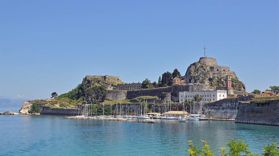
Ionian Islands tours pass two Venetian fortresses in Corfu, the Old Fortress and the New Fortress. The Venetians cut a moat called the Contrafossa through the promontory of the Old Fortress and turned the citadel into an artificial island.
The Old Fortress covers the promontory that held the old town of Corfu in Byzantine times. Its twin peaks gave the city its Western name, because Corfu comes from a Byzantine Greek word for peaks.
The Venetian military engineers Savorgnan and Martinengo designed its bastions between 1545 and 1555. They are considered masterpieces of military engineering. The governor ordered the work after the first Ottoman siege.
In 1718 lightning struck the powder magazine at Castel da Mare. The blast set off three secondary ammunition facilities and destroyed much of the castle, including the palace of the Captain General.
The New Fortress rose on the hill of St. Mark after the Venetians razed 2,000 homes in the suburb of San Rocco. The original architect was the military engineer Ferrante Vitelli.
- Height: The bastion of the New Fortress stands 55 metres above sea level.
- Bastions: Twin bastions are named Skarponas and Epta Anemoi, meaning Seven Winds.
- Artillery: The works held 700 pieces of artillery, with a range estimated to reach the Albanian coast.
- Library: The Old Fortress houses the public library of Corfu in the old British barracks.
The British destroyed the sea defences of the New Fortress in 1864, when Corfu united with Greece. Ionian Islands tours therefore see the Venetian walls without their former sea defences.
What does the Achilleion add to Ionian Islands tours?
Ionian Islands tours include the Achilleion, a palace built on Corfu for Empress Elisabeth of Austria after the loss of her only son, Crown Prince Rudolf. Its design was meant to suggest an ancient palace of mythical Phaeacia.
The site was first a villa owned by the Corfiot philosopher and diplomat Petros Vrailas-Armenis. The Italian architect Raffaele Caritto designed the palace on an area of 200,000 square metres.
The building is in Pompeian style and carries paintings and statues of Achilles. Elisabeth used it only as a private palace, and her husband, Emperor Franz Joseph, disliked sea voyages and never saw it.
German Kaiser Wilhelm II bought the palace in 1907 and used it as a summer residence. He commissioned a bronze statue of Achilles in full hoplite uniform that faces north toward the city.
The base of that bronze statue, a stop on Ionian Islands tours, once carried the line To the Greatest Greek from the Greatest German. The inscription was removed from the base after the Second World War.
- First World War: French and Serbian troops used the palace as a military hospital.
- Orphans: From about 1921 to 1924 the palace housed Armenian orphans from Constantinople.
- Film: The casino scene of the James Bond film For Your Eyes Only was shot at the Achilleion.
- Summit: The palace served as a venue for the European summit of 1994.
The property now operates as a museum within the Greek National Tourism Organization. Ionian Islands tours treat the Achilleion as the island’s link to the courts of Vienna and Berlin.
Why is Paleokastritsa on Ionian Islands tours?
Ionian Islands tours reach Paleokastritsa, a village in northwestern Corfu whose Greek name means Old Little Castle. The name refers to the nearby castle of Angelokastro, and the village is especially known for its great cliffs and nearby beaches.
Angelokastro is a Byzantine castle on the northwest coast. It stands 305 metres on a cliff above the sea and surveys the city of Corfu and the mountains of mainland Greece.
The castle never fell, despite frequent sieges over the centuries, and it sheltered the local peasant population during invasions. It formed a defensive triangle with the castles of Gardiki and Kassiopi.
Tradition places the landing of Odysseus in the bay of Paleokastritsa. In the Odyssey, Kerkyra is the island of the Phaeacians, where Odysseus meets Nausicaa, the daughter of King Alkinoos.
The monastery in Paleokastritsa, a stop on Ionian Islands tours, dates from 1225 and houses a museum. The wider municipal unit of Palaiokastrites covers 48.379 square kilometres and held 3,389 residents at the 2021 census.
- Road: The national road EO24 runs west from the city of Corfu towards Paleokastritsa.
- Villages: The municipal unit includes Liapades, Doukades, Krini and Skripero.
- Gardiki: A thirteenth-century Byzantine castle guards the southwest as the only surviving medieval fortress in the south.
- Reform: Since the 2019 local government reform the area belongs to Central Corfu and the Diapontian Islands.
Paleokastritsa shows the west coast in one view, with a cliff castle above and a bay below. Ionian Islands tours link that bay to the landing of Odysseus.
What do Ionian Islands tours show on the north coast of Corfu?
Ionian Islands tours on the north coast of Corfu stop at Kassiopi, a fishing village of Ancient Greek origin on the northeast shore. The village overlooks the Corfu Channel, and the ruins of its castle stand above the harbour.
One theory derives the name Kassiopi from the Temple of Cassius Zeus, for which the town was celebrated in antiquity. The Roman writer Cicero described a brief stay in its harbour while seeking shelter.
According to Suetonius, Emperor Nero sang at the altar of the temple. In the fifth century the temple became a Christian church honouring the Holy Mother, under the name Panayia Kassopitra.
The church was restored between 1590 and 1591 and received two altars, one for Catholic and one for Orthodox worship. Inscriptions on the church bear the dates 1590, 1670 and 1832.
On Ionian Islands tours Kassiopi Castle is mainly Byzantine, with signs that the walls are older. The Venetians strengthened the walls, and the castle survived Ottoman sieges in the sixteenth century.
- Boats: Motor boats are available for hire in the harbour by the day or week.
- Confusion: The Kassiopi of Corfu is easily mistaken for Cassope in Epirus.
- Etymology: Another theory links the name to Cassiopeia, the queen punished by Poseidon for her vanity.
- Sidari: Sidari is a resort village in the north and the site of an ancient monastery.
The north coast joins an ancient temple, a Byzantine castle and Venetian walls in one village. Ionian Islands tours treat Kassiopi as the main stop on that shore. The Corfu jeep safari post covers the off-road tracks over Mount Pantokrator and the hill villages.
What do Ionian Islands tours show of Corfu by boat?
Ionian Islands tours by boat off Corfu town pass Vido, an island less than a kilometre across at the mouth of the port. It lies about one kilometre north of the Old Fortress and was known to the ancients as Ptychia.
The Corfu boat trip post covers the coastal routes around the island and the islets off the main port. Ionian Islands tours by sea start from that harbour.
Fort Schulenburg rose on Vido between 1716 and 1727, and the French and British later added forts of their own. The fortresses were blown up in 1864 as part of the union agreement.
In the First World War, sick Serbian soldiers were treated on Vido, and over 5,000 people were buried at sea near the island. Serbs call the surrounding waters the Blue Sea Tomb.
Lazaretto lies 1.1 kilometres off the coast northeast of Corfu town and covers 7.1 hectares. A monastery stood there under Venetian rule, and a leprosarium followed later in the sixteenth century.
- Monument: Serbs raised a monument of gratitude to the Greek nation on Vido in the 1930s.
- Mouse Island: Pontikonisi takes its name from the white monastery staircase, which resembles a mouse tail from afar.
- Wildlife: Peacocks, pheasants and rabbits live on Vido.
- Second World War: The Axis occupation held prisoners of the Greek resistance in a camp on Lazaretto.
In 1798 a Russo-Turkish fleet ran Lazaretto as a military hospital. Ionian Islands tours by boat therefore pass islets that served as forts, hospitals and camps in turn.
What do Ionian Islands tours reveal about sailing around Corfu?
Ionian Islands tours that sail around Corfu pass a boundary on the map. Corfu and the Diapontian Islands mark the International Hydrographic Organization border between the Ionian Sea to the south and the Adriatic Sea to the north.
The Corfu sailing tour post covers the sailing side of the island, from the open west coast to the channel that faces the mainland. Ionian Islands tours of that kind begin there.
Under Venice, Corfu was called the Door of Venice, because the whole Adriatic was then the Gulf of Venice. The Venetians held the island from 1401 until 1797.
According to Thucydides, the fleets of Corcyra and Corinth fought the first naval battle recorded in Greek history in 665 BC. In 480 BC the island manned the second-largest Greek fleet, with 60 ships.
After the siege of 1716 the Venetians built an arsenal at Gouvia to service and repair their fleet. The Temple of Hera on Analipsis Hill was visible to ships passing ancient Korkyra.
- Beach: Agios Georgios South has the largest sandy beach on the island.
- Naval power: Korkyra ranked among the three great naval powers of fifth-century BC Greece, with Athens and Corinth.
- Summer: Daytime temperatures in the city of Corfu reach 33 degrees Celsius in summer.
- Humidity: Summers are hot and dry, but relative humidity is high.
Sailors on this coast pass Greek, Byzantine and Venetian landmarks. Ionian Islands tours of that kind read the coast through the sea routes that shaped it.
What do Ionian Islands tours offer in the evenings at sea off Corfu?
Ionian Islands tours that end the day at sea off Corfu look back at the old city from the water. The Old Fortress, restored inside, hosts concerts and Sound and Light productions that recreate historical events with sound and light special effects.
The Corfu sunset cruise post covers the evening hours on the water. Ionian Islands tours of that kind show the same shoreline from the sea, including the walls that Venice built along it.
The gardens of the Old Palaces overlook the bay through old Venetian fortifications and turrets. The Greek royal family once used a wrought-iron staircase to reach the sea baths at the foot of the walls.
Corfu gave modern Greece its first theatre and opera house, built during the Venetian period. The Municipal Theatre replaced it in 1901 and was destroyed in the German bombing of 1943.
The Old Palaces formerly housed the Kings of Greece and, before them, the British governors of the island. Locals now call the old Royal Gardens the Garden of the People.
- Sea baths: Local sea baths sit at the foot of the fortifications around the palace gardens.
- Observation post: The central high point of the citadel carries a military observation post and a giant cross.
- Church: The church of St. George at the foot of the observatory has six Doric columns.
- Art cafe: A cafe on the palace grounds includes its own art gallery.
Evening trips look back at a city that Venice walled and Britain garrisoned. Ionian Islands tours of that kind pair the water with the stone of the old citadel.
How does the cruise port fit Ionian Islands tours?
Ionian Islands tours that arrive by cruise ship use the harbour of Corfu, a favourite stopping place for cruise liners because of its harbour, scenery and wealth of ruins and castles. The New Port lies beside the city.
The Corfu shore excursion post covers the sights that cruise visitors reach from the port, among them the old town and the island’s palaces. Ionian Islands tours by ship start from the same quay.
The huge walls of the New Fortress loom over the road that runs from the New Port to the city. The road passes the fishmarket on its way into town.
The Ioannis Kapodistrias International Airport lies about two kilometres south of Corfu Town and half a kilometre north of Pontikonisi. The airport was founded in 1937 and became international in 1965.
City buses run to the airport, the Achilleion, Gouvia, Afra and Pelekas. The national road EO25 runs south from the city towards the Achilleion and ends in a loop.
- Mon Repos: The former royal summer residence lies south of the city and houses the Museum of Palaiopolis.
- Birth: Prince Philip, Duke of Edinburgh, was born at Mon Repos on 10 June 1921.
- Name: King George I renamed the villa Mon Repos, French for My Rest.
- Builders: The villa was built between 1828 and 1831 for the British Lord High Commissioner Frederick Adam.
Cruise visitors find fortress walls, a royal villa and an airport close to the port. Ionian Islands tours by ship plan around that harbour.
What do Ionian Islands tours add on a day trip from Corfu to Albania?
Ionian Islands tours reach Albania across the Straits of Corfu, which run along the Albanian coast. On the far shore lies Sarande, a city named after a Byzantine monastery of the Forty Saints and set on an open gulf of the Ionian Sea.
The Corfu to Albania day trip post covers the crossing and the sights on the far side. Ionian Islands tours of that kind add a second country to the island visit.
Sarande has a Mediterranean climate with over 300 sunny days a year. In antiquity it was also called the Port of Anchises, after the father of Aeneas, according to Dionysius of Halicarnassus.
Butrint was declared a UNESCO World Heritage Site in 1992 and became a national park in 2000. Excavation has yielded Proto-Corinthian pottery of the seventh century BC, then Corinthian and Attic pottery.
In 31 BC Augustus, fresh from victory at Actium, renewed the plan to make Butrint a veterans’ colony. The new residents built an aqueduct, a Roman bath, houses and a forum complex.
- Earthquake: An earthquake in the third century AD destroyed a large part of the town.
- Triconch Palace: The grand house of a local notable was built around 425.
- Theatre: Inscriptions on the theatre stones mostly record the freeing of enslaved people.
- Castle: Butrint also features the Ali Pasha Castle.
Ionian Islands tours that cross the strait treat the Albanian coast as an extension of Corfu, with Greek, Roman and Byzantine layers visible at Butrint.
What do Ionian Islands tours show on Paxos?
Ionian Islands tours show Paxos as a compact, hilly island south of Corfu, with three harbour settlements on its east coast, a long record of settlement, an annual music festival and a water cave near the northern village of Lakka.
Paxos measures about 10 kilometres from north-west to south-east and reaches up to 3 kilometres in width. Agios Isavros, the highest point, rises to 231 metres. Ionian Islands tours treat it as a compact stop.
Gaios, Lakka and Longos are the three main settlements, and all of them lie on the east coast. Hamlets lie scattered through the hilly interior, away from the harbours.
Tourism replaced olive oil, soap manufacture and fishing as the main industry in the mid-1960s. The resulting construction boom changed the coastline around Gaios. Ionian Islands tours now sail past that altered shoreline.
People have lived on Paxos since prehistoric times. Semi-permanent British residents included Audrey Good, a former commander of UN refugee bases in Epirus, the actor Peter Bull and the actress Susannah York.
The annual Paxos Festival was founded by John Gough and is now organised by the Guildhall School of Music and Drama in London. Events take place in the disused school of Longos.
- Caves: The Water cave of Ypapanti lies near Lakka on the Paxos coast.
- Province: The province of Paxoi, once part of the Corfu Prefecture, was abolished in 2006.
- Season: Festival events run between June and September.
- Winter: Winter visitors face occasional periods of isolation on the island.
The Paxos Antipaxos cruise post covers the sea route around both islands. Ionian Islands tours link that small group to the wider chain of the Ionian Sea.
Where do Ionian Islands tours go around Antipaxos?
Ionian Islands tours go to Antipaxos for its three named beaches and its single harbour at Agrapidia, and they treat the island as the small southern neighbour of Paxos within the same municipality and the same regional unit.
Antipaxos has one harbour, at Agrapidia, and three main beaches. The island belongs to the municipality of Paxoi in the Corfu regional unit, so Ionian Islands tours count both islands as one unit.
The whole municipality covers 30.121 square kilometres. The islets Agios Nikolaos and Panagia protect the harbour of Gaios, while Mongonisi and Kaltsonisi lie off the south-eastern tip of Paxos.
Members of the Agnelli family built a holiday home with a faux medieval tower on a small island near the heel of Paxos. Ionian Islands tours point it out from the water.
Studies of the reptiles of Paxos and Antipaxos, the latest published in 2014 and 2017, confirmed species such as Hemidactylus turcicus and Zamenis longissimus. No amphibians have been reported on the two islands.
Earlier reports of other reptile species, among them Lacerta viridis and Laudakia stellio, were never confirmed. The record therefore stays short and cautious for a pair of islands of this size.
- Vrika: White sand covers this beach.
- Mesovrika: Pebbles cover this beach.
- Voutoumi: Pebbles also cover this beach.
- Screen: The series What We Do in the Shadows places the birthplace of its character Nadja on Antipaxos.
Ionian Islands tours that continue south from Paxos pass from a populated island to one with a very small resident community. The next stop on the chain is Lefkada, joined to the mainland.
Which places define Ionian Islands tours on Lefkada?
Ionian Islands tours on Lefkada follow an island joined to the mainland by a causeway, with a high mountain core, resorts on the east coast, a windsurfing bay in the south and a Corinthian past recorded by ancient writers.
Lefkada is joined to the mainland by a causeway. The island measures 35 kilometres from north to south and 15 kilometres from east to west, and it covers about 302 square kilometres.
Stavrota, at 1,158 metres, is the highest peak. Nidri is the largest resort on the island, and Vasiliki is a windsurfing centre. Ionian Islands tours reach both places.
Ancient sources call Leucas a Corinthian colony, and the Corinthians dug a trench across its isthmus in the 7th century BC. In antiquity a bridge linked the island to the mainland.
That bridge was the longest stone bridge of ancient Greece. Agathocles of Syracuse conquered the town in the 3rd century BC, and Rome annexed it in the next century.
The name Santa Maura is first attested in 1292. An Ottoman admiral captured Lefkada, with Cephalonia and Zakynthos, in 1479. The Venetians later took the island after a sixteen-day siege.
- Municipality: The present municipality was formed in 2011 by merging seven former municipalities.
- Education: The Regional Development Department of the Ionian University is based in Lefkada.
- Natives: The opera singer Agnes Baltsa and Frederick Temple, Archbishop of Canterbury, appear among the notable people of the island.
- Road: Greek National Road 42 passes through Nydri on the east coast.
The Lefkada island tour post covers the island on land, from its mountains to its main town. Ionian Islands tours use the causeway as the way in.
How do Ionian Islands tours follow the Lefkada coast?
Ionian Islands tours follow the Lefkada coast past white cliffs, a cape tied to Sappho, remote beaches reached by stairs or sealed roads, and a southern bay where a thermal wind draws windsurfers to the water each afternoon.
South of Vasiliki lies Cape Lefkada, where Cephalus and the poet Sappho allegedly leapt to their death from the 30 m high cliffs. Cape Dukato, the southernmost tip, sometimes names the whole island.
Porto Katsiki means goat port, and the name is said to come from a time when only goats managed to reach the area. The beach lies 35 km from Lefkada town, near Athani village.
A stairway leads down from the cliff-top parking. The beach has no lodging, and camping is prohibited. Ionian Islands tours by boat therefore reach the sand from the sea.
Egremni is a remote beach on the south-western coast. A sealed road built in the mid-1990s opened it up. An earthquake in November 2015 killed two elderly women and left rubble across the area.
At Vasiliki a local thermal wind known to windsurfers as Eric rises in the afternoon as the land warms. Over a hundred windsurfers can fill the bay at once.
- Nydri: Madouri, Skorpios, Skorpidi and Sparti lie in the sea in front of the town.
- Porto Katsiki: The beach was badly damaged by the earthquake of 2015.
- Egremni: A travel magazine listed it among 13 places with the bluest water in the world.
- Vasiliki: Bike riders and sailing crews also use the area.
The Lefkada boat tour post covers the coast from the water. Ionian Islands tours then turn east to the small islands off Nydri. The Lefkada kayak tour post covers Porto Katsiki, Egremni, Kathisma and the Lefkada lagoon.
Which small islands do Ionian Islands tours reach near Meganisi?
Ionian Islands tours reach Meganisi, whose name means big island, together with the private island of Skorpios, the islet of Sparti and the outlying islands of Kastos and Kalamos, all within sight of the Lefkada coast and the mainland shore.
Meganisi lies just east-south-east of Lefkada and has a municipal area of 22.356 square kilometres. It has three villages: Katomeri in the centre, and the ports of Vathy and Spartochori.
A car ferry links Vathy and Spartochori with Lefkada. Pupils attend school in Nydri on Lefkada, because Meganisi has no secondary school. Researchers believe the island was Homeric Krocylea.
Skorpios is a private island east of Lefkada. The shipping owner Aristotle Onassis bought it in 1963, and his wedding to Jacqueline Kennedy took place there on October 20, 1968.
The island spans 83.2 hectares and holds over 200 varieties of imported trees. Onassis brought sand from Salamis for East Beach. The island is a Natura 2000 area with no more than 5% open to development.
Kastos, east of Lefkada, is 7 km long and 800 m wide, with one village on its east coast. Its church of Agios Ioannis carries wall paintings by Spyridon Gazis. Kalamos is the nearest island.
- Sparti: This islet belongs to the municipality of Meganisi alongside Skorpios.
- Windmills: Kastos has two windmills and three olive presses, none still in use.
- Harbours: Kastos has two harbours for mooring, one at the front of the island and one at the back.
- Burials: Onassis, his son Alexander and his daughter Christina are buried on Skorpios.
Ionian Islands tours then cross the channel towards Ithaca, which lies off the coast of Kefalonia and has its own Homeric claim. The Nydri boat cruise post covers Skorpios, Meganisi, Madouri and the Papanikolis cave.
What do Ionian Islands tours find on Ithaca?
Ionian Islands tours find on Ithaca a mountainous island in two halves, joined by a narrow isthmus, with a deep harbour at Vathy, a long record of occupation and a close link to the Venetians and later rulers of the Ionian Sea.
Ithaca is the second-smallest of the seven main Ionian Islands, after Paxi, and covers 96 square kilometres. It runs 23 km from north to south and 6 km at its widest.
Two halves of about equal size are joined by the isthmus of Aetos, just 600 metres wide. Cape Exogi marks the westernmost point, and the second largest village, Stavros, lies in the north.
Nirito, at 806 metres, is the tallest mountain, followed by Merovigli at 669 metres. The regional unit has about 100 km of coastline. Ionian Islands tours therefore follow its bays rather than its summits.
People have lived on Ithaca since the 4th millennium BCE. The Byzantine period knew the island as Thiaki, and the Venetians wrote Teaki. Under the Ottomans it was Fiaki.
Vathy took shape in the 16th century, when families moved down from Palaiochora. The French built a fortress on Loutsa hill in 1807, and a law of 1978 protects the architecture of the town.
- Dockyard: Over 200 ships were built at the port of Vathy during the 19th century.
- Lazareto: The islet at the harbour mouth carries a chapel built in 1668.
- Revolution: Prominent citizens of Ithaca joined the secret Philiki Etairia, which helped organise the Greek Revolution of 1821.
- French rule: Ithaca was the honorary capital of the French department of Ithaque.
The Ithaca day trip post covers a visit to the island. Ionian Islands tours link it to Homer, which the next section explains.
Why do Ionian Islands tours link Ithaca to Homer?
Ionian Islands tours link Ithaca to Homer because ancient readers placed the home of Odysseus there, although the Odyssey describes the island in terms that scholars have argued over since antiquity, and rival islands have their own supporters.
The Odyssey places Ithaca near a forested mountain called Neriton. Critics note three problems: Homer calls it low-lying, the island is mountainous, and the poem seems to place it furthest west.
Strabo, writing in the 1st century AD, read the phrases as close to the mainland and farthest towards the north. He took Same to be Kefalonia and Doulichion to be an Echinades island.
The Paliki idea has drawn a blunt verdict from scholars, who find that all the geological and geomorphological evidence refutes it. Modern scholars accept modern Ithaca as Homeric Ithaca and treat the gaps as poetic licence.
Coins from Ithaca frequently show Odysseus, and an inscription from the 3rd century BC names a hero-shrine of Odysseus and games called the Odysseia. Ionian Islands tours refer to these finds.
In 2010 archaeologists found the remains of an 8th-century BC palace at Agios Athanasios. The School of Homer site is the only place in the area with possible Linear B inscriptions.
- Polis Cave: Heinrich Schliemann identified this cave near Stavros as one that Odysseus visited.
- Benton: Sylvia Benton researched the cave in the 1930s.
- Worship: Votive offerings show rituals for the nymphs from the Early Helladic to the Roman period.
- Alalcomenae: This town was founded in the southern part of the island, near Aetos.
Homeric site claims call for caution, since the ancient tourist trade shaped other identifications too. Ionian Islands tours present Ithaca as the traditional answer.
What makes Kefalonia central to Ionian Islands tours?
Ionian Islands tours treat Kefalonia as the largest island of the group, with a high fir-covered mountain, four ancient city-states, a long Venetian and British past and a population that fell sharply after the great earthquake of 1953.
Kefalonia covers 773 square kilometres, and Mount Ainos rises to 1,628 metres. Greek fir and black pine cover the upper slopes, and the range forms a national park.
From at least the 6th century BC four city-states shared the island: Pale, Cranii, Same and Pronnoi. They minted their own coins and formed a federation known as the tetrapolis.
A man from Kefalonia, Melampous, won the lyre and song contest at the Pythian Games in 582 BC. Pale sent 200 hoplites to fight the Persians at Plataea.
Rome conquered Same after a long siege in 189 BC. The emperor Hadrian later gave the island to Athens. In the 8th century it became the centre of the Byzantine theme of Cephallenia.
The population reached 70,000 in 1896 and stood at 35,801 in the census of 2011. Ionian Islands tours cross villages whose names end in -ata, such as Metaxata and Chavriata.
- Plains: Level farmland covers less than 15% of the island.
- Arable land: Less than a quarter of the land can be ploughed.
- Surnames: Surnames ending in -atos mark the indigenous families.
- Fortress: The Castle of Saint George became the capital when the Byzantines moved it inland.
The Kefalonia island tour post covers the island on land. Ionian Islands tours then turn to its underground lake, which the next section describes. The day trips from Kefalonia page covers Melissani, Drogarati, Ithaca and Lefkada from Kefalonia.
Why is Melissani central to Ionian Islands tours on Kefalonia?
Ionian Islands tours include Melissani because the lake sits in a sinkhole, formed when limestone collapsed in 1953, and its brackish water is a mix of fresh water from inland and sea water, with a mythical past as the Cave of the Nymphs.
Melissani lies north-west of Sami and about 5 km south-east of Agia Effimia. A collapse of limestone bedrock exposed the groundwater in 1953 and created the sinkhole that holds the lake.
In Greek myth Melissani was the Cave of the Nymphs. Stone near the opening is a honey-like brown. Ionian Islands tours stress the clear water, which lets visitors see rock below the surface.
The groundwater is brackish, a mix of fresh water from inland and sea water pushed in at depth. Ionian Islands tours note that it comes out at the Fridi beach.
Plants grow at the opening of the cave, and the lake bottom is covered with stones. Speleo-divers have explored the huge karst conduits that lie beneath the lake itself.
The entrance has parking beside the main road between Sami and Agia Efimia, which serves the northern part of the island. Visitors report water so clear that boats look as if they float on air.
- Type: The lake forms a kind of cenote.
- Setting: Forest surrounds the cave, and a mountain slope rises to the west.
- Bay: The bay of Sami holds a group of cenotes with deep shafts.
- Karavomylos: The fishing village lies 2 km west of Sami near two caves.
The Melissani cave tour post covers the lake and its boat ride. Ionian Islands tours then visit other caves in the same area.
Where do Ionian Islands tours find Drogarati and the other caves?
Ionian Islands tours find Drogarati and the other caves in a belt of limestone around Sami, Poros and the north, where named caves lie close to villages, and where the Poros gorge holds a cave used since prehistoric times.
Drogarati lies near Chaliotata. It is one of the important natural features of Kefalonia, listed beside Melissani Lake and the Koutavos Lagoon in Argostoli, and Ionian Islands tours treat it as a standard stop.
Other listed caves on Kefalonia include Spileovouno near Fiskardo, Drakospilia near Lixouri and the cave of Agios Gerasimos near Argostoli. Karavomylos, the fishing village west of Sami, sits close to two caves.
The Drakaina cave in the Poros gorge shows human habitation since 5,700 BC. In the Classical period it was linked to the cult of the Nymphs, and a local legend tells of a dragon.
The gorge is 80 metres deep. Local legend says Heracles cut it. Ionian Islands tours that reach Poros can also see the Mycenaean tomb of Tzanata, found in 1991.
The tomb dates to about 1300 BC and is the largest tholos tomb found in north-western Greece. Gold bull horns, a gold double axe and engraved seals are in the Argostoli museum.
- Skala: The Sakkos Cave lies near the 6th-century BC temple of Apollo.
- Ithaca: The Cave of Loizos lies near Stavros, and the Cave of Nymphs lies near Vathy.
- Lefkada: The Cave of the Demon lies near Spartochori.
- Ainos: Caves lie in the north of Mount Ainos.
Ionian Islands tours therefore treat the caves as a group rather than a single stop. The next section moves from the underground to the coast of Kefalonia.
How do Ionian Islands tours reach the Kefalonia coast?
Ionian Islands tours reach the Kefalonia coast by boat and by road at Myrtos, Fiskardo and Assos, where a white pebble beach, a preserved harbour village and a Venetian fortress show different sides of the island and its history.
Myrtos lies between the feet of Agia Dynati and Kalon Oros, which is 901 m high. Its round white cobblestones come from marble, and fine marble in the water gives it a turquoise shade.
The beach has been voted the best Greek beach 12 times. The film Captain Corelli’s Mandolin used it for a mine explosion scene. A steep road with hairpin turns leads down from Divarata.
Fiskardo is the northernmost port of Kefalonia and has been identified with ancient Panormos. It escaped the earthquake of 1953 and kept its original architecture. Ionian Islands tours also stop there by sea.
A Roman grave complex found in 2006 held five burial sites, gold jewellery and bronze artefacts. A well-preserved Roman theatre lies close by, and the village takes its name from Robert Guiscard.
The Assos Castle stands on a rocky hill 170 m high, with walls 2000 metres long. Marino Gentillini built it between 1593 and 1596. Charles Napier called it stronger than Gibraltar.
- Last residents: The 1961 census found 6 people living in the Assos fortress.
- Ports: Poros has a year-round ferry to Kyllini, and Fiskardo links to Lefkada and Ithaca.
- Lixouri: The beaches of Xi, Fteri and Petani lie on the Paliki peninsula.
- Antisamos: The film Captain Corelli’s Mandolin was also shot on this beach.
The Kefalonia boat tour post covers the coast from the water. Ionian Islands tours end on the island with its capital, Argostoli.
What does Argostoli show on Ionian Islands tours?
Ionian Islands tours reach Argostoli, the capital of Kefalonia since 1757, where a British bridge, a rebuilt lighthouse and the memory of the earthquake of 12 August 1953 record how the town was destroyed and was then rebuilt.
Argostoli replaced the old capital, Agios Georgios, as the seat of the island in 1757. It took advantage of a sheltered bay and grew into one of the busiest ports in Greece.
Colonel Charles Philip de Bosset built a wooden bridge across the Koutavos Lagoon in 1813. Stone arches followed four years later. The bridge carried traffic until 2005 and is now closed.
Along the road to the west, sea water vanishes into sinkholes called katavothres. The flow turned a water mill in 1835. The Fanari lighthouse of 1829 was destroyed in 1953 and rebuilt with Doric columns.
German bombing in 1943 shattered buildings in the town. The earthquake of 12 August 1953 measured 6.8, raised the whole island by 60 cm and flattened every building except those of Fiskardo.
Between 445 and 800 people died. The USS Salem was the first ship to bring help, and four Israeli warships followed. Ionian Islands tours recall that the majority of residents emigrated afterwards.
- Bell Tower: It was rebuilt in 1985 to house the original clock mechanism.
- Stamps: The Greek state issued two earthquake stamps on 15 November 1953.
- Presses: Before the earthquake, 200 oil presses worked on the island; 13 do now.
- Zakynthos: Only two buildings survived in the capital of that island.
The earthquake still shapes the island’s towns, which were rebuilt after it. Ionian Islands tours that finish in Argostoli therefore close with the story of recovery.
What do Ionian Islands tours see on Zakynthos?
Ionian Islands tours reach Zakynthos, the third largest of the Ionian Islands, with an area of 405.55 square kilometres and a coastline of 123 kilometres. The island lies in the eastern Ionian Sea, about 20 kilometres west of the Peloponnese mainland.
In the Odyssey, Homer lists 20 nobles from Zakynthos among the 108 suitors of Penelope. Greek myth names the island after Zacynthus, son of the chief Dardanus. Ionian Islands tours meet that name first.
The western half of the island is a mountainous plateau, and steep cliffs line the south-west coast. The eastern half is a fertile plain with long sandy beaches and a dense population.
The Venetians gave Zakynthos the nickname Fiore di Levante, which means Flower of the East. The census of 2021 counted 40,508 residents, and the capital lies on the northern coast.
Ionian Islands tours still pass the small Venetian castle on Bochali hill, above the capital. The hill rises from the fertile eastern plain, which isolated hills interrupt along its length.
- Arrowhead: The tip of the island points to the north-west, towards the open sea.
- Summit: The highest point of the island stands at 758 metres above the sea.
- Size: The island is about 40 kilometres long and 20 kilometres wide.
- Neighbour: Kefalonia lies 15 kilometres to the north of Zakynthos.
The Zakynthos island tour post covers the island by road. Ionian Islands tours treat Zakynthos as the southernmost of the main Ionian group, not counting Kythira. The day trips from Zakynthos page covers Navagio, the Blue Caves and the turtles of Laganas.
How do Ionian Islands tours reach Navagio Beach?
Ionian Islands tours reach Navagio Beach by sea, because high cliffs isolate the cove on the north-west shore of Zakynthos. The beach is also called Shipwreck Beach and Smugglers Cove, and its older name was Agios Georgios.
Ionian Islands tours date the wreck to 5 October 1980, when the coaster MV Panagiotis ran aground at the cove in stormy weather and bad visibility. The hull still rests buried in limestone gravel.
Ionian Islands tours hear a rumour that the ship carried contraband. Court papers suggest that it sailed from Turkey with cigarettes bound for Italy, and that the crew abandoned it to escape the pursuing navy.
A cliff above the beach collapsed in 2018, and the cove closed for a time. It reopened, and anchoring is allowed again, but with limits set because of fears of further landslides.
In September 2022 a magnitude 5.4 earthquake between Kefalonia and Zakynthos set off another landslide. After a site visit in March 2023, experts from the national earthquake protection body recommended a ban on access.
- Ship: MV Panagiotis was a coaster, not a passenger vessel, when it came ashore.
- Old name: The cove first carried the name of Saint George, Agios Georgios.
- Screen: The Korean drama Descendants of the Sun used the cove, and interest rose among Chinese and Korean visitors.
- Safety: Boats can anchor again, but under restrictions that follow the landslides.
The Navagio shipwreck tour post covers the wreck and the cove. Ionian Islands tours treat Navagio as a place to see from the water, within the rules on landing.
What are the blue caves on Ionian Islands tours?
Ionian Islands tours include the blue caves of Zakynthos, sea caves on a cliff coast where the sea does the cutting. Wave action is the main force behind sea caves, and it works fastest along weak zones in the rock.
A sea cave starts at a weak zone in the rock. The surf and the rock particles that it carries widen the crack, and compressed air inside adds to the force.
The west coast of Zakynthos suits that process well, because a mountainous plateau fills the western half of the island and steep cliffs line the south-west coast above the water.
Arches form beside caves. When caves break through a headland, the opening becomes an arch, and a collapsed arch leaves a stack or stump. Arches line the shore from Keri to Skinari.
Sea caves vary in size. Fingal’s Cave on Staffa in Scotland is about 70 metres long, while Matainaka Cave in New Zealand reaches 1.5 kilometres. Ionian Islands tours see the Greek caves from the water.
- Weak zone: A fault or a layer of softer rock gives the sea a place to start cutting.
- Blowholes: Partly submerged caves throw spray into the air as the waves retreat.
- Rock: Caves in igneous rock tend to be larger, because the host rock is stronger.
- Collapse: The cap of an arch keeps eroding after the arch has formed, and the arch falls in the end.
The Zakynthos Blue Caves post covers the caves along the coast and the small boats that enter them. Ionian Islands tours read the cliffs as a slow work of the sea.
Why do Ionian Islands tours watch turtles at Zakynthos?
Ionian Islands tours watch loggerhead turtles in the Bay of Laganas, where the National Marine Park of Zakynthos protects them. Founded in 1999, the park covers 135 square kilometres and is the first national park for sea turtles in the Mediterranean.
The bay holds six nesting beaches: Gerakas, Daphni, Sekania, Kalamaki, East Laganas and the islet of Marathonissi. Together they measure about 5 kilometres, and Sekania ranks among the highest loggerhead nesting concentrations in the world.
The park records 900 to 2,000 nests each year, an average of 80 percent of all nests of the Mediterranean loggerhead population. Females lay their eggs at night between the fifth month and August.
Rules protect the nests. Fishing is strictly prohibited in each of the three marine zones, labelled A, B and C. A code of conduct covers sightseeing, general awareness and marine excursions.
Tourism growth counts as a threat to the park. Speedboats that break the boating ban off the nesting beaches endanger the turtles. Ionian Islands tours therefore depend on the park rules.
- Nesting beaches: Six beaches form the nesting habitat of the bay.
- Wetland: The park also takes in the wetland of Keri Lake.
- Management: The park works with local stakeholders on monitoring, surveillance and certification.
- Status: The loggerhead sea turtle is listed as endangered.
The Zakynthos turtle boat tour post covers the turtles of the bay in detail. Ionian Islands tours at Laganas Bay watch an animal that lives at sea and comes ashore only to nest.
Which sea routes do Ionian Islands tours follow around Zakynthos?
Ionian Islands tours by sea around Zakynthos follow three kinds of route: along the east coast from the capital, across the wide Bay of Laganas in the south, and past the cliffs and rock formations of the west coast.
The main port lies in the capital, on the eastern part of the northern coast. A ferry links it to Kyllini on the mainland, the usual place of arrival by sea from the Peloponnese.
A second port serves the village of Agios Nikolaos on the northern tip. Its ferry runs to Argostoli on Kefalonia, which joins the two islands for travellers who sail between them.
Five minor uninhabited islands belong to the municipality: Marathonisi, Pelouzo, Agios Sostis, Agios Nikolaos and Agios Ioannis. The first three lie in Laganas Bay, and Agios Ioannis lies near Porto Vromi on the west coast.
The peninsulas of Vasilikos in the north and Marathia in the south enclose Laganas Bay, which is wide and shallow. Ionian Islands tours cross it on the way to the nesting beaches.
- Keri: This mountain village in the south of the island has a lighthouse.
- Marathonissi: The islet, also called Turtle Island, has beaches and sea caves.
- Laganas: The largest resort of the island lies on the bay of the same name.
- East shore: The northern and eastern shores hold wide sandy beaches.
The Zakynthos boat trip post covers the routes from the harbour and the stops along each one. Ionian Islands tours choose a route by the coast that they want to see.
What do Ionian Islands tours show at sunset on Zakynthos?
Ionian Islands tours at sunset face west from Zakynthos, where the open Ionian Sea lies beyond the cliffs of the western shore. The Sun sets due west at the spring and autumn equinoxes, and towards the north-west in summer.
Sunset is the moment when the upper edge of the Sun disappears below the horizon. Ionian Islands tours then pass through three stages of twilight, known as civil, nautical and astronomical twilight.
Civil twilight lasts until the Sun is 6 degrees below the horizon. Nautical twilight runs from 6 to 12 degrees, and astronomical twilight from 12 to 18 degrees. Night begins at 18 degrees.
Zakynthos has a hot-summer Mediterranean climate, with hot, dry summers and mild to cool, rainy winters. The average annual temperature stands at about 18.5 degrees Celsius, and plentiful winter rain feeds dense vegetation.
Humidity stays fairly high through the year, even in the summer months. Atmospheric refraction bends the last rays, so the solar disk already sits about one diameter below the horizon when the sunset is seen.
- Direction: The western shore of Zakynthos looks out over the open sea.
- Season: Summers on the island are hot, dry and sunny, with little rain.
- Lighthouse: Keri, a mountain village in the south, has a lighthouse on its shore.
- Twilight: Dusk marks the darkest moment of twilight, just before night.
The Zakynthos sunset cruise post covers evening trips on the water. Ionian Islands tours that end at sunset trade the day for a view of the sky.
Which poets do Ionian Islands tours meet in Zakynthos town?
Ionian Islands tours meet the poets of Zakynthos in the capital, Zakynthos town, also called Chora. Dionysios Solomos, the national poet of Greece, wrote the Hymn to Liberty on the island in 1823, and a statue of him stands in the main square.
The municipal unit of Zakynthos town has a land area of 45.79 square kilometres and 16,996 residents at the 2021 census. It includes the communities of Ampelokipoi, Argasi, Vasilikos, Gaitani and Bochali.
The Hymn to Liberty has 158 stanzas in total. It was printed in Messolonghi a year after Solomos wrote it, and Nikolaos Mantzaros set it to music in 1828.
The first two stanzas became the national anthem of Greece in 1864 and the anthem of Cyprus in 1966. Ionian Islands tours therefore pass the home town of the words of both anthems.
The Museum of Solomos and Eminent Zakynthians stands on St Mark’s plaza. It shows art of the 18th and 19th centuries, sculptures, musical instruments and ceramics, with a focus on Solomos.
Elizabeth Moutzan-Martinegou, the first prominent modern Greek female writer, was born on the island. The Renaissance anatomist Andreas Vesalius died there after a shipwreck on a pilgrimage to the Holy Land.
- Early work: The Rimada is a 16th-century verse romance about Alexander the Great.
- Heptanese School: Its lyrical and satirical poetry followed the Romanticism of Europe.
- Composer: Pavlos Carrer, born in 1829, belonged to a noble family of Zante.
- Solomos: The poet died on 9 February 1857, after the Hymn became known.
Ionian Islands tours find in Zakynthos town a literary centre. Venetian rule gave the island closer contact with western writing than other Greek lands had.
Where do Ionian Islands tours go on Kythira?
Ionian Islands tours reach Kythira, which tradition lists among the seven main Ionian Islands although it lies off the south-eastern tip of the Peloponnese. The island sits between the mainland and Crete, a crossroads of merchants and sailors.
The island covers 279.593 square kilometres. The 2021 census counted about 3,650 people, down from about 14,500 in 1864, as islanders emigrated to Australia, the United States and Germany.
Greek myth makes Kythira the island of Aphrodite, said to have risen from sea foam near its shore. The sea snail that yields Tyrian purple is native to the island, and a Phoenician colony settled there.
After the Byzantine reconquest of Crete in 962, Saint Theodore of Cythera led a resettlement and founded a great monastery at Paliochora. A town grew around it, populated from Laconia.
Venice took the island and called it Cerigo. Kythirans still tell how Barbarossa looted and destroyed Paliochora, and monasteries cling to the rocky hillsides. Ionian Islands tours trace that pirate history.
Only five villages stand on the coast: Platia Amos, Agia Pelagia, Diakofti, Avlemonas and Kapsali. The port of Diakofti serves scheduled routes to Gythion, Kalamata and Piraeus.
- Village names: Over 60 village names end in -anika, after the families that settled each place.
- Honey: Thyme honey is known within Greece for its rich flavour.
- Festivals: Potamos holds the festival of Panagia on 15 August, and Mitata holds a wine festival.
- Archives: The Historical Archives of Kythira are the second largest in the Ionian Islands, after Corfu.
Ionian Islands tours to Kythira cover an island of long trade routes and sparse population. A magnitude 6.9 earthquake in the sea east of the island in 2006 damaged old buildings without loss of life.
How do Ionian Islands tours reach the Diapontia Islands and the Strofades?
Ionian Islands tours name two remote island groups: the Diapontia Islands north-west of Corfu and the Strofades south of Zakynthos. The Diapontia group has 12 islands and islets, and Othoni, its largest island, is the westernmost point of Greece.
Ionian Islands tours to Othoni find an island of 10.8 square kilometres with 457 inhabitants at the 2021 census. Ereikoussa has 366 residents, and Mathraki is the third inhabited island.
In 1537 the fleet of Hayreddin Barbarossa massacred the people of Othoni after a long battle. A white stone cross at Stavros, 217 metres above the sea, still marks that event.
On 29 December 1940 the submarine Proteus sank off Othoni after it sank the steamer Sardegna and an Italian torpedo boat rammed it. It was the first loss of the Greek navy in the war.
The Strofades are two small rocky islands about 44 kilometres south-south-east of Zakynthos. Stamfani holds a fortress monastery built in 1241 for Princess Irene Laskarina, who survived a shipwreck there.
Greek myth placed the Harpies on the Strofades. The islands count as an Important Bird Area, with 2,000 to 3,000 breeding pairs of Scopoli’s shearwaters, and hunting is prohibited there.
- Dialect: Speech on the islands resembles that of Corfu but shows strong Italian and Epirote influence.
- Ereikoussa: Its beaches, Porto and Braghini, carry Italian names from Venetian rule.
- Last monk: Father Grigorios settled at the Strofades monastery in 1976 and left in 2014.
- Earthquake: A magnitude 6.6 quake on 18 November 1997 damaged the monastery.
Ionian Islands tours to these outer islands show the edge of the group. Distance, history and birdlife mark them apart from the main islands.
How did Venetian rule shape what Ionian Islands tours see?
Ionian Islands tours cross lands that Venice held from the mid-14th century until 1797. The islands became the only part of the Greek-speaking world that never came under Ottoman rule, and Venetian names and buildings remain in the harbours and towns.
Kythira came first, indirectly in 1238 and directly after 1363. Corfu became a Venetian vassal in 1386, and Zakynthos returned to Venice in 1485. Kefalonia followed on 24 December 1500 and Ithaca in 1503.
Lefkada completed the set in 1718, under the Treaty of Passarowitz. The governor, the Provveditore generale da Mar, lived on Corfu, and each island had Venetian officials and local councils.
Ionian Islands tours trace a society that split into nobles, citizens and common people, as in Venice. Exports paid for the system: raisins, olive oil and wine. The Venetian lira served as the currency.
Olive oil was the leading product of Corfu, and Venice allowed it to be exported only to Venice. Statistics for 1766 to 1770 count 1,905,917 olive trees on Corfu and 31,884 on Kythira.
Venetian became the official language, while Greek stayed in the countryside. The first literary academy, the Accademia degli Assicurati, opened in Corfu in 1656. The population reached 155,770 by 1794.
- Fortresses: Ten fortresses stood across the islands, three of them on Corfu.
- Religion: Catholics gathered mainly in Corfu and Kefalonia.
- Currency: A special issue of the lira carried the names Corfu, Cefalonia and Zante.
- End: The Treaty of Campo Formio of 17 October 1797 ceded the islands to France.
Ionian Islands tours read Venice in the harbours, the fortresses and the speech of the islands. The republic fell in 1797, but its mark stayed.
What do Ionian Islands tours recall of the Septinsular Republic and British rule?
Ionian Islands tours recall a short republic and a long protectorate. The Septinsular Republic, created in 1800, was the first autonomous Greek state since the fall of the Byzantine Empire in 1453, and British protection began in 1815.
A Russo-Ottoman fleet drove the French out, and the Treaty of Constantinople of 6 April 1800 set up the Republic of the Seven United Islands. The Sultan received an annual tribute of 75,000 piastres.
A Senate in Corfu governed the republic. Its flag showed the Lion of Saint Mark holding seven arrows, one for each island. The Byzantine Constitution had 37 articles and favoured the old noble families.
France regained the islands in 1807 under the Treaty of Tilsit, and Britain seized all but Corfu and Paxos in 1809. In 1815 they became a British protectorate, the United States of the Ionian Islands.
William Ewart Gladstone served as commissioner for three weeks in the winter of 1859. Palmerston decided in 1862 to cede the islands, and Charilaos Trikoupis signed the Treaty of London on 29 March 1864.
Ionian Islands tours pass the sites of that change. The Ionian Parliament acted the union with Greece on 5 October 1864, and the Ionian Academy then closed in support of the University of Athens.
- Fortifications: The treaty required the demolition of the fortifications of Corfu.
- Port: Britain kept the right to use the port of Corfu.
- Academy: The Ionian Academy, a university from 1824, was the first Greek academic institution of modern times.
- Decolonisation: Historians see the cession as the first voluntary decolonisation by Britain.
Ionian Islands tours therefore cross a region that gained self-government in 1800 and joined Greece in 1864. Its institutions came from the Venetians, Russians, Ottomans and British.
What do Ionian Islands tours reveal about Ionian music and culture?
Ionian Islands tours reveal a musical tradition called the Ionian, or Heptanese, school, whose heyday ran from the early 19th century to about the 1950s. Its composers took Italian opera as a model and then built a national music.
The school has two generations: the first from 1815 to the end of the 1860s, and the second from 1871 onward. Mantzaros, Xyndas and Carrer are among its prominent names.
Nikolaos Mantzaros was born in Corfu on 26 October 1795. He composed the first concert aria in Greek in 1827, the Aria Greca, and directed the Philharmonic Society of Corfu from 1841 until his death.
Spyridon Xyndas, a guitar virtuoso born in Corfu in 1812, studied with Mantzaros from 1823. His opera The Parliamentary Candidate of 1867 was the first full-scale opera with a Greek libretto.
Pavlos Carrer, born on Zante in 1829, wrote the three-act opera Isabella d’Aspeno, staged at the San Giacomo theatre of Corfu. He settled in Zante in 1857 to build a national music.
Italian shaped daily life too. Italian was co-official under the Septinsular Republic and the protectorate. In 1907, 2,541 Ionians gave Italian as their mother tongue. Ionian Islands tours still meet that language.
- Opera: Xyndas wrote Anna Winter in 1855 on Dumas’ The Three Musketeers.
- Loss: A German bombing raid on the Municipal Theatre of Corfu in 1943 is believed to have destroyed works of his.
- Schools: In the first year of secondary school, a week held four Greek lessons, three Italian and two English.
- Scores: The Music Museum of the Philharmonic Society of Corfu keeps scores by these composers.
Ionian Islands tours end with a culture that mixed Italian and Greek elements. The music, the language and the lessons of the nineteenth century all show it.
What do Ionian Islands tours cross in the Ionian Sea?
Ionian Islands tours cross the Ionian Sea, an elongated bay of the Mediterranean bounded by the west coast of Greece. Every major island in the sea belongs to Greece, and the deepest point in the Mediterranean, Calypso Deep, lies in its waters.
The sea is bounded by southern Italy, including Calabria, Sicily and the Salento peninsula, to the west. Southern Albania closes it to the north, and the Peloponnese forms part of the Greek shore.
Calypso Deep reaches a depth of 5,109 m and is the deepest spot in the Mediterranean. The sea also counts as one of the seismically active areas of the world.
Ancient Greek writers, especially Aeschylus, linked the name to the myth of Io. In Greek myth, Io swam across the water, so the adjective Ionios became an epithet for the sea.
The name is not related to Ionia, a region of Anatolia. Greek spells the sea with an omicron and Ionia with an omega, and the two words also differ in stress.
Colonizers from the Greek world crossed the sea regularly from at least the eighth century BC to found colonies in Italy, and Ionian Islands tours meet that long history island by island.
- East shore: The major islands lie in the east of the sea and are named collectively the Ionian Islands.
- Main islands: The main islands are Corfu, Kefalonia, Zakynthos, Lefkada and Ithaca.
- Western control: Italy has controlled the western section of the Ionian Sea since 1861.
- Naming legend: One version names Ionius, son of Adrias, as the figure behind the name.
Ionian Islands tours therefore begin with this sea, which sets the distances, the weather and the sailing routes that later sections follow.
How does the climate shape Ionian Islands tours through the year?
Ionian Islands tours run in a Mediterranean climate, a dry summer climate caused by the subtropical ridge. Summers stay hot and dry with little cloud, while winters bring the rain, so the seasons differ sharply along the Ionian coast.
Climate scientists describe the type as Cs and place it in the lower mid-latitudes, between 30 and 45 degrees of latitude. The subtropical ridge moves towards the pole in summer and towards the equator in winter.
Parga on the Epirus coast has a hot-summer Mediterranean climate, marked Csa. Its average annual temperature is 16.5 degrees Celsius, and about 1219 mm of precipitation falls there each year.
Precipitation in Parga falls mainly in the winter months, with little in the summer. Igoumenitsa, up the coast, repeats the pattern with rainy winters that run mild to cool.
In summer the dry air keeps cloud to a minimum. Strong sun heats the land by day and it cools quickly after dark, so the daily temperature range stays wide.
Higher ground differs. In Thesprotia the coastal climate is Mediterranean, but cold winters of a semi-alpine climate dominate the east and the higher elevations, so inland Ionian Islands tours meet another season.
- Vegetation: The natural cover in the European Mediterranean Basin is garrigue or maquis scrub.
- Crops: Wheat, grapes and olives form the Mediterranean trinity of traditional crops.
- Latitude: The climate sits on western coasts, between roughly 30 and 45 degrees from the equator.
- Name: The type is named after the coastal regions of the Mediterranean Sea.
Ionian Islands tours therefore meet dry summers and rainy winters, and the next sections on winds, sea life and food follow the same seasonal split.
How do the winds affect Ionian Islands tours at sea?
Ionian Islands tours at sea depend on the wind. The etesians are strong, dry north winds that blow periodically from mid-spring to mid-September, and they can reach force 7 to 8 on the Beaufort scale in the Aegean Basin.
Etesian winds peak in the afternoon and tend to ease at night, although a spell can last for days. In the northern Aegean they blow as winds of northeasterly to northerly direction.
Yachts and ferries between the islands cannot always sail in such conditions, so crossings depend on the forecast. Leisure sailors, however, value the same winds as a steady sailing breeze.
In the central Aegean the etesians blow from the north, and in the southern Aegean they blow as northwesterlies, so their direction shifts across the basin. Writers have described them since ancient times.
The weather that goes with the etesians is ordinarily fine and clear, and the northerly breeze tempers the fierce summer heat of the region. Their name points to a yearly fluctuation in frequency.
Wind draws sports to the coast. Vasiliki on Lefkada is a windsurfing centre, and Kastro Point at Parga attracts surfers, although the level of skill required is high for Ionian Islands tours that include it.
- Direction: Etesians blow from between north-east and north-west, depending on local topography.
- Cause: A trough of low pressure over the eastern Mediterranean enforces the winds in summer.
- Dry air: The etesians are dry winds with no opposite wind in winter.
- Sailing club: The Municipal Sailing Club is located in Igoumenitsa on the mainland coast.
Ionian Islands tours at sea therefore follow the forecast, since a summer wind can change the plan for a boat or ferry crossing.
Which sea life do Ionian Islands tours meet?
Ionian Islands tours share the water with loggerhead sea turtles, Mediterranean monk seals and dolphins. Greece is the leading nesting country for loggerheads in the Mediterranean, and the Ionian Sea is one of the remaining home ranges of the monk seal.
Greece records more than 3,000 loggerhead nests per year, the highest count along the Mediterranean. Greek authorities do not allow planes to take off or land at night at Zakynthos because of the nesting turtles.
The Mediterranean works as a nursery for juvenile loggerheads and as a gathering place for adults in spring and summer. Almost 45% of the juvenile population has migrated from the Atlantic Ocean.
Between 800 and 1000 Mediterranean monk seals survive in isolated subpopulations, according to the latest estimate. Other remaining populations live in southwestern Turkey and in the Ionian Sea, the water of Ionian Islands tours.
A pregnant monk seal uses an inaccessible undersea cave to give birth. Historical descriptions show that the species used open beaches until the 18th century, and it feeds on fish, octopus and squid.
Dolphins appear in Greek myth as helpers of humankind. Ancient Greeks regarded dolphins riding in a ship wake as a good omen, and Greek coins show riders on the back of a dolphin.
- Seal diet: A monk seal eats up to 3 kg of food per day.
- Seal fur: The historical range of the species ran from the Atlantic coast of West Africa east to the Black Sea.
- Conservation: The Greek group ARCHELON works for the conservation of loggerheads.
- Fisheries: Bottlenose dolphins conflict with small-scale coastal fisheries in parts of the Mediterranean.
Ionian Islands tours therefore sit in water shared with protected animals, and the nesting season shapes the rules for boats and aircraft.
Why do olive groves line the routes of Ionian Islands tours?
Ionian Islands tours pass olive groves because the olive tree thrives in a Mediterranean climate and has grown around the region for millennia. The record says the tree reached Greece sometime in the 28th century BC, having been spread westward by the Phoenicians.
Olea europaea is an evergreen tree that grows in a Mediterranean climate. Fossil evidence places its origins 20 to 40 million years ago, in what is now Italy and the eastern Mediterranean Basin.
People first cultivated the olive in the Mediterranean between 8,000 and 6,000 years ago. Cultivation spread around the basin through trade and migration, and Greek colonies carried olive farming to Spain.
Spain, Italy and Greece lead the world in commercial olive production. Italy, Greece and Turkey collectively account for 59% of the global olive oil market, so Ionian Islands tours cross a crop of weight.
The Spartans and other Greeks used olive oil to rub themselves while exercising in the gymnasia. Olive oil has long been a common ingredient in ancient Greek and Roman cooking.
On Kastos, an island east of Lefkada, two windmills and three olive presses remain, and none of them functions anymore. The island has a population of about 40, who work mainly in tourism services and fishing.
- Word origin: The word olive derives from Latin, which took it from an early Greek form.
- Linear B: The oldest attested forms of the Greek words for olive are Mycenaean.
- Cuisine: Wine and olive oil have always been central to Greek cuisine.
- Parga: Sarakiniko beach at Parga lies near a small river and olive trees.
Ionian Islands tours therefore cross a landscape where the olive tree is both a farm crop and a record of long Mediterranean history.
What food do Ionian Islands tours put on the table?
Ionian Islands tours meet a cuisine with more Italian influences than any other part of Greece, a result of the long Venetian rule. The food of Corfu, Kefalonia, Lefkada and Zakynthos shares that base but keeps its own local dishes.
The list of Corfu dishes includes bourdeto and bianco, both fish dishes, together with savoro. Poulenta, a form of polenta, and niokos, a type of orzo pasta, show the Italian side of the table.
Corfu also has salado, a local salami, noumboulo, a pork tenderloin, and polpettes, which are meatballs. Fogatsa is a bread similar to tsoureki, and colombina is a type of tsoureki.
Kefalonia lists kreatopita, a meat pie, and sofigado, lamb or veal cooked with vegetables. Its menu also includes prentza, a creamy cheese, and the salads andrakla and pissara.
Lefkada has frygadeli, a lamb dish, salami Lefkadas and galatopita, a dessert. Zakynthos has sgatzeto, goat meat, and cooks bourdeto with meat instead of fish, a detail that sets the islands apart.
Corfu desserts include bianceta, bolsevikos and mandola, while rafiolia, fritoura and frigania are sweets of Zakynthos. Pasteli and mandolato are common sweets across the Ionian islands, from Corfu to Zakynthos on Ionian Islands tours.
- Drinks: Corfu serves ginger beer, called tzitzibira.
- Othonoi: The small island of Othonoi offers patatopita, a potato pie.
- Lefkada drink: Soumada is a drink of Lefkada.
- Name: The cuisine is also called Heptanesean cuisine.
Ionian Islands tours therefore read like a menu of Venetian history, with each island adding its own dish to a shared Italian base. The Corfu food tour post covers the dishes, kumquat and olive oil of Corfu.
Which wines appear on Ionian Islands tours?
Ionian Islands tours reach four of the wine appellations of Greece: Kefalonia, Corfu, Zakynthos and Lefkada. Robola is a white grape variety grown primarily on Cephalonia, and its wines tend to be dry and medium bodied, with a distinct lemon note.
Robola is early ripening and can produce high-acid wines with significant phenolic levels. Wine expert Oz Clarke adds that robola wines can show a flinty character as well as the lemon note.
Historians once thought robola was the Friuli grape ribolla, brought to north-east Italy by Venetian merchants trading with Cephalonia in the 13th century. DNA profiling in the 21st century has cast doubt on that theory.
The Vitis International Variety Catalogue now classifies robola as a separate variety. The grape has also gone by synonyms over the years, such as Asporombola, Robbola and Rompola.
Greek winemaking goes back 6,500 years, and Greece has about 200 vine varieties. The ancient Greeks made wine in their colonies in Italy, Sicily, southern France and Spain.
Across the water, Epirus on the mainland adds the Zitsa appellation to the Greek list, so a coastal route from Parga can pair mainland wine with island wine on Ionian Islands tours.
- Soil: Robola vines grow in the limestone soils of Cephalonia.
- Land of vines: The Greeks called southern Italy Oenotria, the land of vines.
- Myth: Greeks embedded the arrival of winemaking in the myths of Dionysus and Aristaeus.
- Retsina: Retsina is a traditional Greek wine flavoured with pine resin.
Ionian Islands tours therefore trace a wine story that runs from ancient colonies to a single white grape on Cephalonia. The Kefalonia wine tour post covers the Robola vineyards of the Omala valley and the tastings.
Which airports serve Ionian Islands tours?
Ionian Islands tours are served by airports on Corfu, Kefalonia and Zakynthos, and by Aktion National Airport on the mainland, which serves Preveza and Lefkada. The airports of Corfu, Zante and Kefalonia ranked in the top ten in Greece for international arrivals in 2012.
Corfu airport was founded in 1937. During the Second World War, German and Italian forces used it as a base for transport and fighter aircraft, and its runway measured 600 m.
The first commercial flight took place on 19 April 1949 from Athens. By the end of April 1949 the runway had reached 800 m, and it grew to 1,260 m by the end of 1951.
The last extension began in 1957 and finished in 1959, giving a runway of 2,373 m. The airport became international in April 1965, and the new terminal was completed in 1972.
Zakynthos airport opened in 1972 and lies 4.3 km from Zakynthos city, close to Laganas, Tsilivi and Kalamaki. A new 22,150 m2 terminal was completed in 2008 for Ionian Islands tours.
Aktion National Airport began operations in 1968 and is also used by NATO. In December 2015 a joint venture signed to run 14 regional airports, including all four, for 40 years.
- Arrivals: The three island airports recorded 1,386,289 international arrivals in 2012.
- Corfu rank: Corfu was the sixth airport nationwide by number of arrivals.
- Kefalonia growth: Kefalonia airport had the biggest nationwide increase in 2012, at 13.11%.
- Marine park: Kalamaki beach lies on the Zakynthos approach path and is part of the National Marine Park of Zakynthos.
Ionian Islands tours therefore begin at a short list of airports, each with its own history of runway growth and privatisation.
How do ferries link the mainland to Ionian Islands tours?
Ionian Islands tours reach the sea by the mainland ports of Igoumenitsa and Patras. Igoumenitsa is the chief port of Thesprotia and Epirus and one of the largest passenger ports of Greece, connecting the north-western mainland with the Ionian Islands and Italy.
Ferry routes cross the east and north of the Ionian Sea between Patras and Igoumenitsa in Greece and Brindisi and Ancona in Italy. Further routes run westward from Piraeus.
Igoumenitsa has two ports, the Old Port and the New Port. The New Port is the second busiest passenger port in Greece after Piraeus, ahead of the ports of Heraklion and Patras.
The first phase of the New Port was completed in 2012. The second phase, finished by 2016, enabled the port to serve large cruise ships on Ionian Islands tours.
The A2 motorway, called Egnatia Odos, is 670 km long and ends at Igoumenitsa. It opened in 2009 and links the Ionian coast with Thessaloniki and the Turkish border.
Patras lies 215 km west of Athens and is the third-largest city in Greece. Its port is a nodal point for trade and communication with Italy and Western Europe.
- Rebuilt town: A new settlement grew around the Igoumenitsa ferry terminal in the 1950s and 1960s, after the town was destroyed in 1944.
- Beach: Drepanos beach near Igoumenitsa is one of the longest sand beaches in the region, at over 7 kilometres.
- Population: The 2021 census recorded 10,315 inhabitants in Igoumenitsa proper.
- Name: The name Igoumenitsa derives from the Greek word Igoumeni, which means commander or abbot.
Ionian Islands tours therefore depend on mainland ports, and Igoumenitsa and Patras handle the long routes towards Italy and the islands.
Why do Ionian Islands tours stop at Parga and the mainland coast?
Ionian Islands tours stop at Parga because the town lies on the Ionian coast between Preveza and Igoumenitsa, and it is a resort town known for its natural environment. Built in the shape of an amphitheatre, Parga is known as the Bride of Epirus.
The residents of Parga first built the castle on the hill above the town in the 11th century to protect it from pirates. The Venetians rebuilt it in the 13th century.
In 1537 the Ottoman admiral Hayreddin Barbarossa burned the fortress. The Venetians rebuilt it for the third and last time in 1572, and the winged lion of Saint Mark still shows on the gate.
Parga passed under Venetian control in 1401 and was run as a mainland exclave of Corfu. The name first appears in 1318, and the ancient town of Toryne stood nearby.
Valtos beach lies near the castle. Sarakiniko lies 12 km from the town centre, and small boats connect it with the port. The Parga boat trip post covers sea outings from this coast.
Preveza is the capital of its regional unit, and the ruins of ancient Nicopolis lie 7 km north of it. The Preveza dolphin watching post covers wildlife outings from the town.
- Buses: KTEL runs suburban buses between Parga and the towns of Igoumenitsa and Preveza.
- Airport: Parga lies 65 km from Aktio, which has seasonal flights to Athens and Thessaloniki.
- Toryne: The ancient town of Toryne took its name from the ladle shape of its beach.
- Founding: King Pyrrhus founded the town of Berenike near Preveza in 290 BC.
Ionian Islands tours therefore link island ports to a mainland coast with its own castle, beaches and history, with Epirus rising behind it.
How do Ionian Islands tours move between the islands?
Ionian Islands tours move between the islands by sea. The seven principal islands, from north to south, are Corfu, Paxos, Lefkada, Ithaca, Kefalonia, Zakynthos and Kythira, and six of them lie off the west coast of Greece in the Ionian Sea.
The seventh, Kythira, lies off the southern tip of the Peloponnese. The Ionian Islands Region comprises all the islands except Kythira, which was integrated into the Attica Region.
The region is the smallest by area of the thirteen administrative regions of Greece. It is based at Corfu, the island with the largest population among the major islands.
A decentralised administration based at Patras supervises the region along with two others. Ionian Islands tours therefore cross an island group that is managed from both Corfu and the mainland.
Small islands extend the map of Ionian Islands tours. Kastos, east of Lefkada, is 7 km long and 800 m wide, and its nearest island is Kalamos, with a deep channel between them.
- Parga boats: In summer, tourists arrive at Parga by boat from Paxos, Antipaxos and Corfu.
- Kastos harbours: Kastos has one village, on its east coast, and two harbours for boat mooring.
- Kastos size: Kastos covers 5.901 square kilometres, and its highest point is 142 metres.
- Shipyards: Double-ended ferries are built in Greece, in the shipyards of Perama and Salamis.
Ionian Islands tours therefore treat the sea as the main road, with harbours of every size serving as stops between the principal islands.
What does Epirus add to Ionian Islands tours beyond the coast?
Ionian Islands tours reach Epirus, the region of north-western Greece that borders the Ionian Sea and the Ionian Islands to the west and Albania to the north. It covers about 9,200 km2, and its terrain is rugged and mountainous.
Epirus is made up largely of mountainous ridges. Its highest spot is Mount Smolikas at 2,637 metres, and the Pindus Mountains separate the region from Macedonia and Thessaly.
The Vikos-Aoos and Pindus National Parks lie in the Ioannina part of the region. The animal life includes bears, wolves, foxes, deer and lynxes, and the vegetation is made up mainly of coniferous species.
The four regional units of Epirus are Thesprotia, Ioannina, Arta and Preveza. Around 320,000 people live in the region, and Ioannina, the capital, holds nearly a third of them.
Sheep and goat herding is important, and Epirus provides more than 45% of the meat for the Greek market. Famous dairy brands there make feta cheese, and tobacco is grown around Ioannina.
Dodona, Passaron, Nicopolis, Ioannina Castle and Parga Castle are listed among its archaeological sites. The Epirus tours post covers the whole region beyond the coast for Ionian Islands tours that continue inland.
- Gitanae: Gitanae, a town of the 4th century BC near Igoumenitsa, had a theatre seating 2,500.
- Thesprotia: Thesprotia is named after the Thesprotians, an ancient tribe of the region.
- Climate: The climate of Epirus is mainly alpine.
- Tourism: Tourism, especially eco-tourism, is an important part of the local economy.
Ionian Islands tours therefore reach a mountain region just behind the coast, with parks, castles and ancient sites near the sea.
What do travellers ask about Ionian Islands tours?
Ionian Islands tours cover a region based at Corfu, the smallest in Greece by area, and a group of seven principal islands. Questions concern names, size, money and travel, and the answers below draw on published records of the island group.
Which islands do Ionian Islands tours include?
The group counts seven principal islands from north to south: Corfu, Paxos, Lefkada, Ithaca, Kefalonia, Zakynthos and Kythira. Six lie off the west coast of Greece, while Kythira sits off the southern tip of the Peloponnese and belongs to the Attica Region.
What older names do Ionian Islands tours meet on maps?
Under Venice the islands acquired Venetian names. Kerkyra was Corfu, Ithaki was Val di Compare, Kythera was Cerigo, Lefkada was Santa Maura and Zakynthos was Zante. These names still appear in English and Italian, so older maps and books use them for Ionian Islands tours.
How large is the region behind Ionian Islands tours?
The Ionian Islands Region is the smallest of the thirteen regions of Greece by area. Its population was 207,855 in 2011, and it ranks third in population density, with 90.1 people per km2 against 81.96 nationally. The foreign-born population in 2001 was 19,360.
What economic role do Ionian Islands tours play?
Tourism is the major industry today, after emigration and the decline of fishing and marginal agriculture reduced the population. In 2012 unemployment in the region was 14.7, the lowest among Greek regions, against 24.2 nationally, while the regional GDP for 2010 was 4,029 million euros.